Walk #114: Tranent to Edinburgh
 |
 |
|
General Data
| Date Walked | 19/09/2000 |
| County | Lothian |
| Start Location | Tranent |
| End Location | Edinburgh |
| Start time | 08.50 |
| End time | 12.40 |
| Distance | 10.6 miles |
| Description | This was a fairly boring walk into Edinburgh, something that is shown by the fact that the highlight of the day was the walk along the "Innocent Railway", a disused railway line that is followed for a while, along with it's tunnel. |
| Pack | Today I carried full Pennine Way kit. |
| Condition | I feel okay after this walk. There was a lot of road and tarmac walking today, but it was a relatively short day so I did not suffer too much. I have bought some Ralgex spray to use on my knee and thigh, so hopefully that will help relieve the slight pain that I am getting from them. Apart from these slight pains everything is fine. |
| Weather | Today's weather was quite nice. It was a mixture of sunny and cloudy periods, with no sign of any wind. It was cooler today than it has been for the last couple of days, and the wind meant that I was sometimes cold. |
| OS map | Landranger number 66 (Edinburgh, Penicuik & North Berwick) |
 |
Map of the walk
Maps courtesy of Google Maps. Route for indicative purposes only, and may have been plotted after the walk. Please let me have comments on what you think of this new format. For a detailed table of timings for this walk, please see the table file.
Notes
I have nothing much to say about today as it was a rather unspectacular (by the standard of the last few days) positioning walk into the centre of Edinburgh.
When I got into the centre of Edinburgh I dropped my pack off at the Backpacker's Hostel and then went into the city to post some of the maps and guidebooks that I have finished with on this trip. I also called into the Tourist Information office to get some information on accommodation and transport for the next few day's walking, and to get some photos I have taken of the trip so far developed.
After I had done all this I decided not to walk any further today as I feel that having an afternoon's rest will do me some good, particularly as Edinburgh is such a fascinating city to explore. So I spent some time walking around and enjoying what is a surprisingly nice city.
For this reason I am going to leave my pack here tomorrow and walk on towards Dunfermline, and when I get there catch a train back into the centre of Edinburgh. This means that I get a day without having to carry my pack, and I can also stay in this cheap hostel for one more night. The day after I can catch a train back to Dunfermline and continue my walk northwest from there.
I am very impressed by Edinburgh, especially as some people had warned me that it was a very dark and forbidding granite city. Instead I found a lovely and lively city, and staying at the backpackers Hostel means that I get to meet people from many other countries (indeed, tonight I think that I am the only Englishman in the Hostel, as it is full of (mainly) Australians and South Africans).
Within a few hours of getting to Edinburgh I decided that this was really a city in which I could live, if only the job opportunities in my area of work were available. This is highly unusual, as I am usually a great cynic when it comes to cities, being at heart a country lad. The reason for this great fondness for Edinburgh probably lies in the combination of narrow streets, nooks and crannies and great big hills rising up out of the centre of the city.
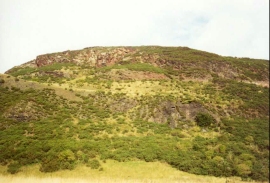
On the walk into the centre of the city this morning I passed the southern flank of Arthur's Seat, and what an amazing sight it was. I was taken aback that the centre of a modern British city could have such an amazing hill - the highly weathered remains of an old Volcano - within it's boundaries. I could just imagine climbing up it every day if I lived in the city.
The buildings are also very nice in Edinburgh - the area around Waverley station and the Royal Mile is full of old and historic buildings. I could never get bored of the architecture of the city - it is very rich, and the darkness of the granite lends itself well to the buildings that it is used upon.
The first part of the walk as far as Fisherrow was fairly unspectacular, but the section from Fisherrow to the centre of Edinburgh was very pleasant as it got off the roads and followed a footpath and cycleway. The course of the latter mostly consisted of the course of the old "Innocent Railway" (the Edinburgh and Dalkeith railway), and included a walk though a fairly long (518 metre) tunnel. Before the tunnel views of the southern side of Arthur's Seat were available, including the rock faces of Lion's Haunch and Samson's Ribs.
This railway was the first one in Scotland to carry passengers, and the gradient thought the tunnel is a steep 1 in 30, with the highest end being to the west. It was constructed between 1826 and 1831 by James Jardine at a total cost of £80,000. It was initially horse powered, with cable haulage up the incline through the tunnel. It was given the designation of "Innocent Railway" because it was completely accident free.
Directions
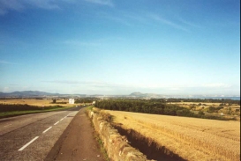
From the town of Tranent head westwards down the A199. Although the day consists almost totally of road and paved path and cycleway walking, there are pavements the whole way lining the road route. The road passes under a series of power lines and then crosses over the A1(T).
The road then continues to a roundabout, under which passes the East Coast Main Line railway. Cross over the roundabout and continue along the A199 to another roundabout. At this roundabout turn left and head westwards along the B6454 towards Inverask.
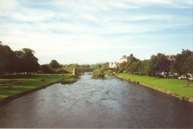
This road meets the A6124. Continue along this road as it turns to the right (north) to a church and another junction in Musselburgh. Continue straight across this junction and cross over the River Esk by a bridge. The road then continues through Fisherrow and meets the sea by the harbour and the attractive beach at Fisherrow.
Shortly after the harbour, and shortly before the junction with the B6415 Musselburgh Road is reached in Joppa, a footpath leads off to the left through a nature reserve. This path follows a stream all the way into the outskirts of Edinburgh. It shortly passes above and to the left of Brunstane golf course before coming out beside Daiches Braes road. The path still follows the stream and crosses a railway line by a bridge.
On the other side of the railway the path passes through a car park and crosses a dual carriageway by an underpass. On the other side of the road it continues through a slightly run-down area of greenery and comes to Duddingston Park South road.
Across the road the stream and the path start to curve to the left and heads soth for a period past blocks of flats near Bingham Drive. The stream eventually passes under the railway line that was crossed earlier. At this point the path becomes a cycleway and leaves the stream to follow the railway line westwards.
After a short while the cycleway squeezes between the railway line to the south and Bingham Medway road to the north. It continues on and as the line starts to curve to the left (south) it continues on, crossing Duddingston Road West. Here the cycleway joins the route of the old "Innocent Railway", which shall be followed all the way into the centre of Edinburgh.
The Innocent railway passes to the south of Duddingston Loch and Arthur's Seat, and enters a long tunnel. The tunnel emerges on a road called East Parkside beside some nice flats. A short path then connects with Leonard's Bank Road. Follow thus as it bends to the left and meets St Leonard's Street at a T-junction.
Turn right down St Leonard's Street and follow it until it ends in a T-junction with Drummond Street. Turn left down Drummond Street and then turn right along the busy South Bridge Street. This then crosses Cowgate and High Street (part of the Royal Mile). Turn left down High Street and then almost immediately right down Cockburn Street. The Backpacker's hostel is to the right down this road, just after the Scotsman Pub. Past the Hostel some steps leads off to the right, leading down to Waverley railway station.
Distances
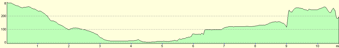
| From | To | Distance (m) | Ascent (ft) | Descent (ft) |
|---|---|---|---|---|
| Tranent | Fisherrow harbour | 5.1 | 52 | 344 |
| Fisherrow harbour | Edinburgh | 5.5 | 302 | 120 |
This makes a total distance of 10.6 miles, with 354 feet of ascent and 464 feet of descent.
For more information on profiles, ascents and descents, see this page
Accommodation
I spent the night in the Backpacker's Hostel, in Cockburn street in Edinburgh, which is between the station and the Royal Mile. This is a very nice hostel (if you like that sort of thing, which I do), and cost £11.50 a night.
Disclaimer
Please note that I take no responsibility for anything that may happen when following these directions. If you intend to follow this route, then please use the relevant maps and check the route out before you go out. As always when walking, use common sense and you should be fine.
If you find any information on any of these routes that is inaccurate, or you wish to add anything, then please email me.
All images on this site are © of the author. Any reproduction, retransmissions, or republication of all or part of any document found on this site is expressly prohibited, unless the author has explicitly granted its prior written consent to so reproduce, retransmit, or republish the material. All other rights reserved.
Although this site includes links providing convenient direct access to other Internet sites, I do not endorse, approve, certify or make warranties or representations as to the accuracy of the information on these sites.
And finally, enjoy your walking!
This walk was mentioned in the following routes:
| My sectional Land's End to John O'Groats walk |
Nearby walks
| # | Title | Walk length (miles) |
|---|---|---|
| 113 | Carfraemill to Tranent | 20.8 |
| 115 | Edinburgh to Dunfermline | 17.4 |
| 222 | Edinburgh Castle to Seton Sands | 14.0 |
|
|

|