Walk #113: Carfraemill to Tranent
 |
 |
|
General Data
| Date Walked | 18/09/2000 |
| County | Borders, Lothian |
| Start Location | Carfraemill |
| End Location | Tranent |
| Start time | 08.50 |
| End time | 17.50 |
| Distance | 20.8 miles |
| Description | This was a lovely day's walk, including the traverse of the Lammermuir Hills and the highest point in the range, Lammer Law, with superb views in all directions. The second half of the day was road walking towards Edinburgh. |
| Pack | Today I carried full Pennine Way kit. |
| Condition | Considering this was such a long day I am relatively fine. My shoulders ache slightly more than they have done for the last few days, but my feet were okay until near the end of the walk. The biggest problem of the day is that whilst I was walking towards Pencaitland my left knee started hurting when the leg is fully extended. The underside of the knee is slightly sore, but it is nothing major and I am hopeful that it will be okay in the morning. |
| Weather | This morning was very nice, with cloud and sunny spells helping me on the climb up to Crib Law and Lammer Law. On the top of Lammer Law the weather allowed some lovely and expansive views around all points of the compass, but there was a bitter wind which I did not want to stay in for too long. In the afternoon there were two short but sharp showers that caused me to put my coat on, but I son dried out afterwards in some hot sunshine. |
| OS map | Landranger number 66 (Edinburgh, Penicuik & North Berwick) |
 |
Map of the walk
Maps courtesy of Google Maps. Route for indicative purposes only, and may have been plotted after the walk. Please let me have comments on what you think of this new format. For a detailed table of timings for this walk, please see the table file.
Notes
This was a stupendous day for so many reasons. Not only did I complete the highest point of the walk so far, the traverse of the Lammermuir Hills in beautiful weather, but I also walked much farther that I had been planning to, to such a degree that I may now be three-quarters of a day ahead of schedule.
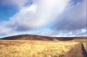
The day started with the slow but steady ascent up to Lammer Law, the highest point in the immediate area. This walk proves to be far less strenuous that I had been expecting it to be, and at Tollishill I met up with four older people who had parked their car there and were getting ready to start a little walk. I walked with them up to the summit of Lammer Law, chatting about various things on the way.
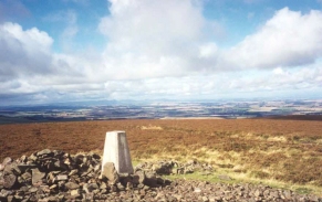
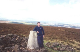
The view from the top of Lammer Law was fantastic, with views over the Firth of Forth and Edinburgh to the north, the Eildon and Cheviot Hills to the south and the Pentland hills to the west. The only problem on the summit was the wind, which was quite chilling on the exposed top and caused my fingers to go numb despite the warm sun.
I felt good at the summit, and I made good time on the descent to Longyester. This was where I had been scheduled to finish for the day, and as I felt fine I decided to walk on a bit further.
I therefore made my target for the day either East Saltoun or Pencaitland, which were on the route for my walk into Edinburgh. I took my time on the road walk between the villages on the route to ensure that I did not strain anything.
When I got to East Saltoun I phoned up the nearest Tourist Information office, and discovered that East Saltoun, Pencaitland or the nearby Ormiston did not have any accommodation, a fact that I found surprising as they were villages of some size. The nearest place with any accommodation was Tranent, which was three of four miles away from Pencaitland in a northerly direction. I still had the option of camping out somewhere on my original route, but as Tranent is quite near to Musselborough (which is on my route) then I decided to alter my route accordingly.
The last three or four miles were quite hard going, and it would have been better if I had not have had to do them. However having done them I am very well set up for the next couple of day's walking. If I manage to get as far as Queensferry tomorrow then I shall be a day ahead of schedule without having to have dropped too many miles off my original route, which means that I am well set up for the rest of the trip.
Sick thing of the day: The pub that I visited in Tranent was playing "Suicide Blonde" by the band INXS, this being the day after Paula Yates died.
Directions
From Carfraemill Hotel head up the road which follows the valley of Kelphope Burn. After a kilometre a junction is reached, at which the route follows the main route which goes to the right and does not take the road going uphill to the left. The road soon crosses the Burn via an attractive bridge, and then heads north for three kilometres, crossing the Burn twice via recently rebuilt bridges (rebuilt to allow Salmon to reach the upper reaches of the Burn).
Just after a little road heads uphill to the right to Dodcleugh Farm, the road bends slightly to the west. When a section of woodland starts on the left a road leads sharply uphill to the right to Tollishill Farm.
From the farm the road becomes an unpaved track, leading across the saddle between Windy Law to the southeast and Hog Hill to the northwest under some high-tension power cables. The track then leads around to the northeast as it passes just to the east of Crib Law, before heading northwards again and over the border between the Scottish Borders and East Lothian.
The track then continues on alongside a fence to a summit. From here another track leads off through a gate to the left a short distance to Lammer Law, which at 527 metres is the highest point of the Lammermuir Hills, and which is well worth a visit for the wonderful views which are available over the Lammermuir Hills, the Firth of Forth, the Pentland Hills and even Edinburgh itself. After you have finished at Lammer Law, return to the original track.
Descend northwards and then north-northeastwards along the track, past a disused quarry and over a small hill to Blinkbonny wood, passing through a gate where the track becomes a paved minor road. Pass through the wood and head onto the very small settlement of Longyester.
In Longyester turn left a road and then almost immediately left again, to head westwards past Pishwanton Wood To Latch, Long Newton and then Kidlaw. Just past Kidlaw there is a road junction to the right which heads past Aikeyside, Leehouses and a 218-metre trig point (hidden between a gate and a hedge in a field beside the road). This road ends at the B6368 road.
Turn right along the B6368 road for a very short distance, and then left along another road that passes a sawmill and through Petersmuir wood. The road then turns slightly to the right to pass roughly northwards past the Skimmer Hills to the village of East Saltoun.
In East Saltoun join the B6355 and follow it through the village past the church. The road angles around to the northwest past Saltoun Home Farm before angling westwards across a stream and into Redmains, at the northeasterly side of Birns Water from Pencaitland.
Cross the A6093 and head north up the B6355. The road curves around to the west and then near Wintinhill it turns northwesterly to pass through New Winton and on into the outskirts of Tranent.
The B6355 meets the B6371 and they continue north-northwestwards downhill into Tranent. They end at the A199, and my B&B was a couple of hundred yards to the right up the A199.
Distances
| From | To | Distance (m) | Ascent (ft) | Descent (ft) |
|---|---|---|---|---|
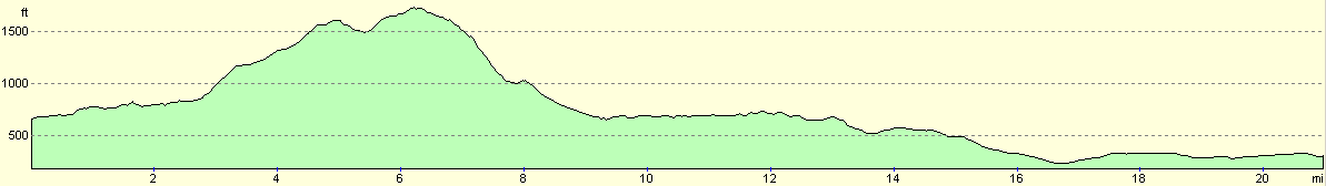
| Carfraemill | Lammer Law | 6.2 | 1322 | 279 |
| Lammer Law | Longyester | 2.9 | 56 | 1109 |
| Longyester | East Saltoun | 6.1 | 318 | 561 |
| East Saltoun | Tranent | 5.6 | 203 | 338 |
This makes a total distance of 20.8 miles, with 1899 feet of ascent and 2287 feet of descent.
For more information on profiles, ascents and descents, see this page
Accommodation
I stayed in a B&B in Tranent. I cannot remember the name of it, but there were several to choose from along with a couple of hotels.
Disclaimer
Please note that I take no responsibility for anything that may happen when following these directions. If you intend to follow this route, then please use the relevant maps and check the route out before you go out. As always when walking, use common sense and you should be fine.
If you find any information on any of these routes that is inaccurate, or you wish to add anything, then please email me.
All images on this site are © of the author. Any reproduction, retransmissions, or republication of all or part of any document found on this site is expressly prohibited, unless the author has explicitly granted its prior written consent to so reproduce, retransmit, or republish the material. All other rights reserved.
Although this site includes links providing convenient direct access to other Internet sites, I do not endorse, approve, certify or make warranties or representations as to the accuracy of the information on these sites.
And finally, enjoy your walking!
This walk was mentioned in the following routes:
| My sectional Land's End to John O'Groats walk |
Nearby walks
| # | Title | Walk length (miles) |
|---|---|---|
| 112 | Melrose to Carfraemill | 14.7 |
| 114 | Tranent to Edinburgh | 10.6 |
| 222 | Edinburgh Castle to Seton Sands | 14.0 |
|
|

|