Walk #294: Hythe to Dungeness
 |
 |
|
General Data
| Date Walked | 12/12/2002 |
| County | Kent |
| Start Location | Hythe (Kent) |
| End Location | Dungeness |
| Start time | 09.15 |
| End time | 14.25 |
| Distance | 14.7 miles |
| Description | This was a fairly boring walk following the coast and roads south from Hythe. |
| Pack | Today I carried my 30-litre Karrimor HotRock rucksack, which was filled with my packed lunch, waterproof leggings, water bottle and a couple of spare shirts, together with the usual assortment of odds and ends. |
| Condition | After the first couple of miles of today's walk my legs felt very leaden, and the walk was harder than I would otherwise have expected for this reason. Near the end of the walk I sat down on a bench for twenty minutes, and this seemed to help. I had no problems with my left ankle at all, for which I was very grateful. |
| Weather | There was a little drizzle at the start of the walk for ten minutes, but this was not enough to force me to out my hood up. Fortunately this was the only rain that I saw all day, although it remained overcast and slightly misty throughout the day. It was a great deal warmer than it had been over the last couple of days, and although it was not warm at least I was not very cold. The wind had also died down from yesterday, which I was glad about. |
| OS map | Landranger number 189 (Ashford & Romney Marsh, Rye & Folkestone) |
 |
 |
|
 |
 |
|
Map of the walk
Maps courtesy of Google Maps. Route for indicative purposes only, and may have been plotted after the walk. Please let me have comments on what you think of this new format. For a detailed table of timings for this walk, please see the table file.
 |
Notes
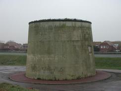
When I got to Hythe the red flag was flying over the ranges, so I realised that I would have to divert inland to avoid the ranges. Unfortunately this involved walking along the A259(T) which skirts the northern side of the range. There was a pavement that meant that I did not have to risk my life on the busy road, and as I walked I could hear gunfire coming from the range. Near the end of the diversion I came across the fairly impressive Dymchurch Redoubt, an old fort that marks the southern end of the range. Some soldiers were running along the top of the redoubt and jumping down into it - goodness knows what they were doing.
As I walked towards Littlestone-on-Sea I could see a large concrete structure out to sea, barely visible through the haze. This is the remains of a section of Mulberry harbour, which were a vital part of the invasion of Europe in 1944. The Mulberry Harbours were large concrete sectional harbours that were towed over to the beachheads in France to avoid having to attempt taking one of the large French ports before the allies had lots of equipment over. The system worked exceptionally well, although the part I saw today had sunk on the way over to France. This whole are had a massive part to play in the second world war, and Dungeness was one of the two places where PLUTO - PipeLine Under The Ocean - started. This was a series of long pipelines that were unrolled across the channel to France shortly after D-Day that allowed fuel to be pumped across, which was a much safer and quicker method of getting fuel across than using tankers. The system could pump one million gallons of fuel a day across the channel from Dungesness and the sister pipeline that started from Sandown on the Isle of Wight. I have always been amazed by the ingenuity of people during the second world war who thought up such incredible and large schemes to get around problems - although I daresay that for every scheme that worked there were many more that were tried and did not work. This whole stretch of coast is just full of old defences - from the basic Second World War pillboxes to Redoubts and the seemingly ubiquitous Martello Towers.
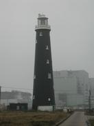
Dungesness is famous (or perhaps infamous) for its two nuclear power stations. It also has two lighthouses; a tall one near the station that is now disused, and a modern concrete one built in 1961 as the beam from the old one was blocked by the power station. I could not really decide if I liked the new lighthouse; it is very different from a traditional lighthouse but it is nice enough in its own way - I have certainly seen worse modern structures. The old lighthouse was built in 1901 to 1904, and was in use until 1960. It was the fourth lighthouse on the site, the first having been built during the reign of James I in 1615.
All day I have been following the route of the 15-inch gauge Romney, Hythe and Dymnchurch Railway, which runs from Hythe down to Dungeness. Count Louis Zborowski and Captain Jack Howey opened this in 1927 as 'The world's smallest public railway'. In season it should be possible to catch the train back to the start of the walk in Hythe, but the trains were not running today.
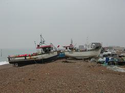
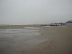
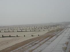
I saw the first significantly large stretch of beach since Southend-on-Sea today, and it was a bit of a culture shock to see large expanses of sand after many days of seawalls and shingle beaches. I knelt down on one knee and scooped up the sand into my hands and let it run through my fingers, which had a very cathartic effect. Before I reached Dungeness the beach became shingle once again, so I walked along the road once again as I hate walking along shingle.
Sam drove up to Margate today so that she could get the window replaced. This has now been done, but they did not have a couple of the clips available so these have not been replaced; at least the window is secured, however. It was very nice of the people at the Margate Motorcaravan Centre to fit us in as they were fully booked, but fortunately Sam managed to persuade them to fit us in. By the time we met in Dungeness she was very tired after all the driving, and she was very glad that it was over for the day. As usual, she is being wonderful.
I am finding it quite stressful chasing the daylight - I am not a fast walker and therefore it takes me a fair while to walk a good distance every day. I also dislike walking at night - you do not get any of the views and I am very paranoid about twisting my ankle as it is harder to see where I am putting my feet. Basically I hate these short days. Today I really wanted to take an hour off so that I could rest, but I really could not afford the time (and it is worse on days when I do a longer distance). Roll on the days when I have only seven hours of darkness!
I met Sam at the Romney, Hythe and Dymchurch Railway station at Dungeness, where she had parked the van. We were both thirsty so we decided to go into the station café for a cup of coffee. Whilst in there I asked about the status of the Lydd army ranges and whether I could follow the footpath along the beach. A man said that it probably was not wise to walk along the beach even if the reed flags were not flying, so I am going to have to make a diversion into Lydd, which will involve yet more road walking.
Directions
This walk starts off on the road beside the sea in Hythe. Walk along the road until it bends sharply to the right. If there is a red flag flying a little further along the beach then it is unsafe to continue along the beach and you will have to take the route that I describe here. Follow the road around the bend and head northwards for a little under a kilometre until it ends at a T-junction. At the junction turn left along a road for a short distance until it ends at a T-junction with the A259(T) road.
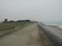
Turn left down the A259(T) and follow it as it heads southwestwards around the northwestern edge of the Hythe Ranges. The road continues for a couple of miles until it reaches the Dymchurch Redoubt on the left, shortly after which it meets the seafront. Here leave the road and climb up onto the seawall. Follow the seawall as it heads southwestwards past Dymchurch and then St Mary's Bay before eventually reaching Littlestone-on-Sea. This is a long walk of many miles along the sea wall, but it was enjoyable nonetheless.
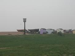
At Littlestone-on-Sea the seawall ends, so either continue on along the shingle beach or join the road that runs alongside the beach. I did the latter, and follow it as it head southwards through Greatstone-on-Sea and Lydd-on-Sea until it turns sharply to the right at The Pilot pub. Follow the road around the bend and as it crosses the railway line and then take the first road off to the left. This road is the access road into the Dungeness Estate. Follow this road as it heads southwards past some lovely little huts until the modern new lighthouse is reached. At the lighthouse turn right and follow a narrow road westwards to the Romney, Hythe and Dymchurch Railway Station at Dungeness, where this walk ends.
Distances
| From | To | Distance (m) | Ascent (ft) | Descent (ft) |
|---|---|---|---|---|
| Hythe | St Mary's Bay | 7.6 | 20 | 20 |
| St Mary's Bay | Dungeness | 7.1 | 72 | 56 |
This makes a total distance of 14.7 miles, with 92 feet of ascent and 76 feet of descent.
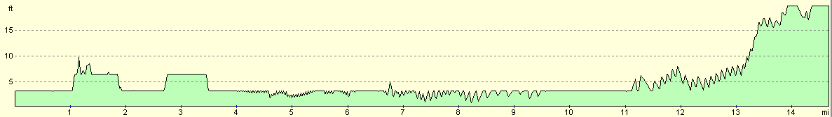
For more information on profiles, ascents and descents, see this page
Accommodation
As there was no campsite in Dungeness we decided to park on the roadside. The foghorn of Dungeness lighthouse was sounding every so often, so we decided that it would be better if we drove the van a few miles into Lydd so that was could get a better nights sleep.
Disclaimer
Please note that I take no responsibility for anything that may happen when following these directions. If you intend to follow this route, then please use the relevant maps and check the route out before you go out. As always when walking, use common sense and you should be fine.
If you find any information on any of these routes that is inaccurate, or you wish to add anything, then please email me.
All images on this site are © of the author. Any reproduction, retransmissions, or republication of all or part of any document found on this site is expressly prohibited, unless the author has explicitly granted its prior written consent to so reproduce, retransmit, or republish the material. All other rights reserved.
Although this site includes links providing convenient direct access to other Internet sites, I do not endorse, approve, certify or make warranties or representations as to the accuracy of the information on these sites.
And finally, enjoy your walking!
This walk was mentioned in the following routes:
| My walk around the coastline of Britain |
Nearby walks
| # | Title | Walk length (miles) |
|---|---|---|
| 293 | St Margaret's at Cliffe to Hythe | 17.1 |
| 295 | Dungeness to Winchelsea Beach | 17.1 |
| 683 | Shepherdswell to Folkestone | 18.5 |
|
|

|