Walk #293: St Margaret's at Cliffe to Hythe
 |
 |
|
General Data
| Date Walked | 11/12/2002 |
| County | Kent |
| Start Location | St Margarets at Cliffe |
| End Location | Hythe (Kent) |
| Start time | 08.13 |
| End time | 15.24 |
| Distance | 17.1 miles |
| Description | This was a lovely walk along the cliffs from St Margaret's at Cliffe to Folkestone, taking in the white cliffs of Dover, which was followed by a flat walk to Hythe. |
| Pack | Today I carried my 30-litre Karrimor HotRock rucksack, which was filled with my packed lunch, waterproof leggings, water bottle and a couple of spare shirts, together with the usual assortment of odds and ends. |
| Condition | I feel absolutely fine after this walk, and could easily have walked further. My ankle only gave a couple of twinges, which is surprising considering that this was the most strenuous day I have had in a long while. My left knee gave me trouble on the first ascent, but this soon disappeared once I had reached the top. |
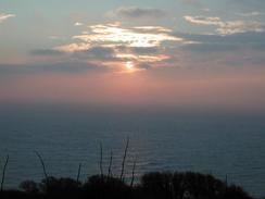
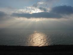
| Weather | Wind was again the main factor with today's weather. I was extremely blustery on the cliff tops, but fortunately it was more of a tail wind than a head wind, which helped me more than it hindered me. There were some sunny periods today, but it was mostly cloudy overhead. It was bitterly cold at times, particularly when the wind was blowing, and it was fortunate that there was not any rain as I would have been very cold if it had rained. |
| OS map | Landranger number 179 (Canterbury & East Kent, Dover & Margate) |
 |
 |
|
 |
 |
|
Map of the walk
Maps courtesy of Google Maps. Route for indicative purposes only, and may have been plotted after the walk. Please let me have comments on what you think of this new format. For a detailed table of timings for this walk, please see the table file.
 |
 |
|
 |
 |
|
Notes
The cove at St Margeret's Bay which I came to first thing on this walk is the nearest cove to France, and the pub is the nearest one to France. It is also the bay from where the majority of cross-channel swimmers set off. After looking at the water for a while I realised that I would much rather spend a year walking around the coastline of Britain rather than a day swimming across to France - the people who do it must really be superbly fit athletes. It is a very nice little bay, although Sam had difficulty getting the van down the road from the top yesterday.
I had forgotten to charge my mobile phone last night, and so I walked for the first couple of hours with it switched off to conserve charge. As I was approaching Dover I received a text message from Sam asking me to phone her urgently. I found this slightly worrying, and when I did phone her up it turned out that she had had a little incident with Mervan. Apparently she had been trying to get into a car park at a superstore that had a very narrow entrance, and although the front of the van had got through the rear driver-side window had been smashed beyond repair. Sam was in a real state but she already had the process of getting a replacement in hand, so I continued on the walk. I was really concerned at first, but as the day went on the views calmed me down and by the time I met Sam in Folkestone to see the damage I was much more philosophical. It could have been much worse; the window (which is double-glazed plastic) and the window fittings have been totally smashed, but the body of the van is totally undamaged. The window is going to cost three hundred pounds to replace, and it looks as though it my be possible to do it tomorrow or Friday in Margate, which is not too far to go. The real problem is that the window is easy to open now an therefore the van is unsecured if we were to leave it; and also that Sam is now more nervous about driving the van.
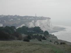
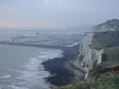
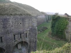
As I walked towards and through Dover, Dover Castle became visible. This is a very impressive castle to look at, and I really would like to take a look around it sometimes. As I climbed up the Western Cliffs of Dover I cam across something I was not expecting - the Drop Redoubt Fort. This is a very impressive structure that was completed by 1808. It had a fairly unusual purpose; it was designed not to stop invasion but to provide an impenetrable base from which soldiers could attack the rear flanks of the enemy once they had passed through Dover. The ditches around the fort are fifty feet deep, and the firing slits allow every inch of the trench between the walls to be covered in fire. By 1867 the fortifications on the heights could house 4,000 men and the castle 3,000, making them very important fortification nationally. The importance of the fort fell over the years, and in the Second World War it was down to housing a company of Commandos whose job was to sabotage the fort in case of German invasion. The fort is a magnificent structure and is a scheduled ancient monument; it would be lovely to see it restored and opened to the public.
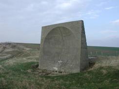
For many years I had always wanted to see something called a sound mirror. These are large concrete structures in coastal regions that were a very low-tech method of airborne early warning in the twenties. The mirror is a large parabolic concrete dish facing out to sea, and the detector was a man sitting at the focal point of the parabola. The idea was for these to be situated towards expected routes planes would take from the continent, and that the dish would concentrate any sounds of the planes coming in, giving a few minutes extra warning. I had heard and seen pictures of these devices, but I had never actually seen one myself. There was one near Spurn Head earlier in this walk but I could not find it as I passed it, today, however, I was in more luck. As I was walking along the cycle path along he top of Abbot's Cliff I could see a large triangular structure ahead of me. I assumed that it was some form of memorial, but it turned out that I was seeing a sound mirror end-on. I spent a few minutes looking around it, and tried to find the focal point of the dish, but this was impossible given the wind, which details one of the many problems that this system had. The dishes feel into disuse after the onset of radar technology, and the dishes now seem like some arcane memorial to what was once modern technology.
It was most disappointing that the day was so hazy, as I am sure that I would have got some excellent photographs if it head been clear. Instead everything beyond the middle distance is blurred and hazy, which rather spoils them. The haze also meant that I had no chance of seeing France form the cliffs at Dover, which I had not really expect to be possible on the exact day that I visited but I had hoped may be the case.
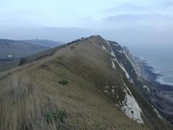
I am very surprised at how good I am feeling after this walk. It was the first time in weeks - well over a month, in fact - that I have had significant cliffs to walk over for most of the day, and yet at the end of the day I could easily have walked further. My pace was slower than normal today, which I think is probably to be expected considering the terrain, but nonetheless I managed to get a good distance done before it got dark. I now have only another couple of weeks of days getting shorter before the shortest day of the year and they starts getting longer once more, which is something that I will very much look forward to. The main problem today was that I was exceptionally tired this evening, and when we got to the campsite I just fell into a sort of vegetative state and really did not feel like doing any work. My mind was totally shot and I really could not concentrate on anything. The worst thing was that I could not sleep either, so I stayed up relatively late for me and watched television.
Directions
This walk starts off at the Dover Patrol Memorial, on the cliffs to the northeast of St Mararet's at Cliffe. It follows the Saxon Shore Way with a few little variations all the way, and so route finding is quite easy - just follow the way markers. From the war memorial walk down the path near the cliff edge southwestwards, descending down to steps that lead down into St Margaret's Bay. In the bay climb up the road past the pub and then turn to the left along a footpath that emerges onto a road. This road leads past the Pines Garden before turning to the left up a track that leads to the cliff edge.
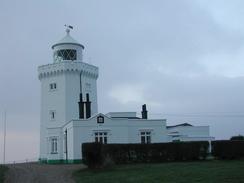
The path heads southwestwards along the cliff edge before it joins a track to skirt inland around South Foreland Lighthouse. It then goes back to the cliff edge and continues on, contouring around the little valleys at Fan Bay and Langdon Bay before climbing up towards the large aerial at a coastguard station. The path then reaches a car park before descending down towards Dover. It passes under a concrete bridge that carries a road over to the harbour before reaching a dual-carriageway road at a roundabout.
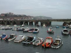
Follow the dual carriageway westward beside the harbour until another roundabout is reached. At this roundabout turn right and continue on too a pedestrian crossing. Cross the road and then turn left and then right to head uphill along another road. A short distance up this road a footpath leads uphill along some steps up onto the Western Heights. At the top of the steps turn right and follow a path that skirts two sides of the Drop Redoubt Fort before it drops down to meet a road. Turn left along this road and follow it as it descends down to meet the A20(T) at a roundabout. At the roundabout turn right and walk along a pavement that starts to rise up until a subway is met on the right.
At the subway a path leads off to the left. Take this footpath as it heads steeply uphill, going over the mouth of a railway tunnel before reaching the top of Shakespeare Cliff. It then continues on, passing above Samphire Hoe and heading on to Abbot's Cliff where it joins a cycle path. After a while the footpath leaves the cycle path and continues on, joining a track for a short distance before diverting off to the left onto the cliff edge once more, where it proceeds westwards towards and past the Battle of Britain memorial at Capel-le-Ferne.
The footpath then steeply downhill until it becomes a narrow track that lead down to a Martello Tower. Continue on southwards across a grassy area to a bright white Martello Tower, and then descend a short distance to the right towards a road beside a pub. Follow this road as it skirts the seafront towards the harbour. At a junction turn left and descend past a school and pass under some railway arches, immediately after which there is a main road. Turn left down this road and follow it past the harbour and then turn right down another road. Follow this road as it parallels the sea front, and then join he seawall once the road ends.
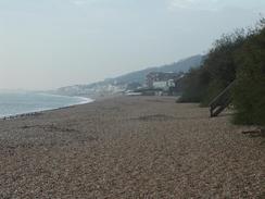
Continue westwards along the seawall and one it ends either walk along the beach or along roads slightly inland. Pass Sandgate Castle and continue westwards either on or paralleling the A259(T) until a road leads off to the left before the A259(T) turns away inland. Go down this road, which runs beside the seawall, along which there is a footpath and cycle path. Head westwards for three kilometres along the seawall into Hythe, until the seawall ends just before a Martello Tower when the road turns away sharply to the right. This is where this walk ends.
Distances
| From | To | Distance (m) | Ascent (ft) | Descent (ft) |
|---|---|---|---|---|
| St Margaret's at Cliffe | Dover | 4.8 | 889 | 1165 |
| Dover | Folkestone | 7.4 | 1581 | 1578 |
| Folkestone | Hythe | 4.9 | 236 | 256 |
This makes a total distance of 17.1 miles, with 2706 feet of ascent and 2999 feet of descent.
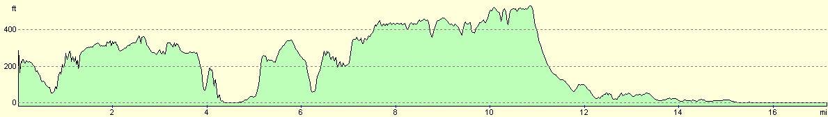
For more information on profiles, ascents and descents, see this page
Accommodation
We stayed at Black Horse Farm Caravan Club Site, 385 Canterbury Road, Densole, Folkestone, CT18 7BG. This site cost us ten pounds and twenty-five pence for the night, and was a very good and well-kept site that we have no complaints about. It was further away from the end of the walk then we normally go, but the site was well worth it.
Disclaimer
Please note that I take no responsibility for anything that may happen when following these directions. If you intend to follow this route, then please use the relevant maps and check the route out before you go out. As always when walking, use common sense and you should be fine.
If you find any information on any of these routes that is inaccurate, or you wish to add anything, then please email me.
All images on this site are © of the author. Any reproduction, retransmissions, or republication of all or part of any document found on this site is expressly prohibited, unless the author has explicitly granted its prior written consent to so reproduce, retransmit, or republish the material. All other rights reserved.
Although this site includes links providing convenient direct access to other Internet sites, I do not endorse, approve, certify or make warranties or representations as to the accuracy of the information on these sites.
And finally, enjoy your walking!
This walk was mentioned in the following routes:
| My walk around the coastline of Britain |
Nearby walks
| # | Title | Walk length (miles) |
|---|---|---|
| 292 | Ramsgate to St Margaret's at Cliffe | 17.7 |
| 294 | Hythe to Dungeness | 14.7 |
| 682 | Chilham to Shepherdswell | 19.7 |
|
|

|