Walk #769: Bodfari to Prestatyn
 |
 |
|
General Data
| Date Walked | 10/04/2007 |
| County | Clwyd |
| Start Location | Bodfari |
| End Location | Prestatyn Station |
| Start time | 06.32 |
| End time | 12.21 |
| Distance | 12.7 miles |
| Description | This was a very pleasant walk following Offa's Dyke path as it headed down from the hills towards the sea at Prestatyn. |
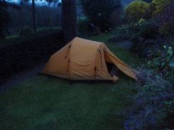
| Pack | Today I carried my 80-litre Macpac Glissade rucksack, containing a North Face Blue Kazoo sleeping bag, my North Face Westwind tent, clothes, waterproofs and other camping items, including cooking gear. |
| Condition | My legs are fairly tired after this walk, but aside from this I am fine. |
| Weather | The morning was fairly cloudy, and although this did not life into the afternoon the skies became generally brighter. There was still a stiff breeze, but it was a nearly perfect temperature for backpacking after a mild night. |
| OS map | Landranger number 116 (Denbigh & Colwyn Bay) |
 |
 |
|
 |
 |
|
Map of the walk
Maps courtesy of Google Maps. Route for indicative purposes only, and may have been plotted after the walk. Please let me have comments on what you think of this new format. For a detailed table of timings for this walk, please see the table file.
 |
 |
|
 |
 |
|
Notes
When I awoke the next morning I unzipped my tent and was greeted with a sky that was cloudier than it had been when I had gone to sleep. It had been a pleasantly warm night, and there had been a breeze that had prevented any condensation from building up inside the tent. Almost immediately I started packing my rucksack up, as I am keen to be able to catch a train back from Prestatyn a little after one this afternoon - there are other trains that will get me back today, but they all go via London rather than Nuneaton, and consequently cost much more.
Despite this I took my time packing up, and at about half past six I shouldered my rucksack and set off into what was still a slightly dark sky as the sun had not yet fully risen. My first task was to get back the couple of hundred yards along the road back to the trail, and on the way I passed a dead badger that had almost fully been turned inside out after being run over by a car - it had not been on the road when I had arrived yesterday afternoon, so it had obviously only just happened.
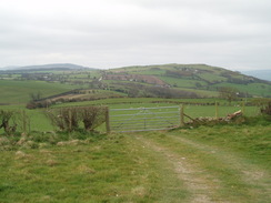
The trail took me northwards along a road, initially climbing fairly steeply before leveling out as it passed some woodland on the right at Sodom. There were some good views to be had to the left, and despite the early hour I was plenty warm enough. Outside a farm there were two snowploughs that can be fitted onto the front of lorries, and shortly after this the trail left the road and a path climbed up to the top of the first hill of the day, Cefn Du, which is apparently an outlier of the Clywdian hill range that I crossed yesterday.
The path then descended from the hill northwards down to a road, crossing a field that was full of bleating sheep and lambs, making quite a cacophony until I met the road. This headed uphill once more slightly and an early-morning jogger passed me before it started descending to meet a larger road. Another climb along a road followed and this was basically the pattern for the rest of the day - a series of relatively small ascents and descents, few particularly steep but with scarce level sections until the very end.
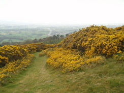
A short distance up the road the trail left the road and started skirting around the flanks of Moel Maenefa before descending across a field that was covered in gorse in flower to reach a minor road. Ahead I could see and hear the busy A55 road, and although it was close by it seemed to take an age to reach it as the path took an indirect route, going down to meet the road before paralleling it to reach a bridge across the road. On the other side of this footbridge there were some steps down but also a ramp, the steps cutting down through the ramp in a curious but most efficient manner, and a short road section led me down into Rhuallt.
This seemed like quite a nice little village and there was a welcoming village sign, but I did not stay long and instead followed the road northwards towards Brynllithrig Hall. After this there was a very steep climb, the steepest of the day so far, as it headed northeastwards up the wooded hillside. I was forced to take this slope slowly, and I rested a couple of time and used the opportunity yet again to look back over the plain below. It was therefore a relief when the gradient slackened and a good path led me onwards, passing a cottage before reaching a road.
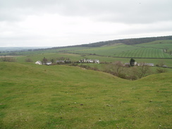
Squirrels bounded across this road from the trees on either side as I walked along it for about a kilometre, before a footpath took me across a field towards the little village of Marian Cwm. I was forced to stop on a step and tie my boot laces, which for the first time on this trip had come undone. The looseness of the boot had caused my left heel to start aching as the sock had fallen down around my ankle, and so I ensured that the boots were extra tightly tied before setting off once again.
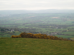
A climb took me up onto some moorland over the top of a hill called Marian Ffrith, and there were some reasonable views to be had from here, including some of the sea, which for the first time on the trip I could clearly see. The path headed down to a farm, where another crossed fields to reach a track that took me down towards Marian Mill. There were several water sluices and streams in this area, and by one building there were the few remnants of an old water mill, the central metal axle and hub clearly visible, but only a few rotted wooden struts still attached to it.
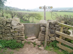
Yet another road walk took me uphill slightly towards the A5151 road, and after carefully crossing this more footpaths took me onwards to another road before climbing up a slight hill across fields. Here I came across what was by far the worst stile of the trip, consisting simply of two wooden uprights with three metal rungs between them, the bottommost of them being a fair height up. This resembled a wide, truncated ladder, and with an overgrown hedge to the right it proved quite strenuous to get over with my heavy pack on.
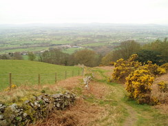
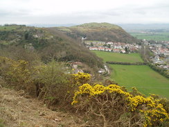
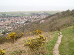
Another climb took me past another road and onto the southern end of the sharp ridge called Prestatyn Cliffs. The views from here were very good, and I could even see the waves breaking against the beach in the distance ahead. This last day of the trail is rightly regarded as being far from the best, but there were some highlights, and the cliffs were definitely one of them. I enjoyed the walk along them, and had a quick rest at an old, ruined cottage that was nestled into the hillside. There was an information board in this, and I took my boots off and massaged my heels before going over to have a look at it. The sun was shining and I was feeling quite warm and euphoric at the end of the walk being so near.
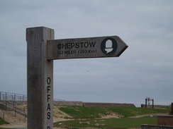
From the ruins a short but stiff climb took me to the top of the cliffs where I studied the views once again, and then the trail dropped along a footpath, a firm fence on the left guarding the path from the sheer drop into an old quarry below. On the descent I met a couple walking up, and we ended up chatting for five minutes before I continued on downwards. The nearness of the end of the walk made me feel really happy, and I passed a sign stating the distance back to the start of the walk near Chepstow.
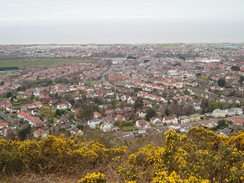
Unfortunately the trail soon joined roads, initially continuing to fall before leveling off and entering the outskirts of Prestatyn. There followed a long and fairly boring road walk, heading arrow-straight northwestwards through the suburbs and finally the high street, with shops on either side. The way that Prestatyn has developed is shown by the railway, which literally slices the town in two as it had been built before the town was particularly large. I therefore had to cross the railway via the footbridge over the line at the station, and after this came rather a dingy walk towards the sea front.
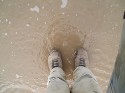
To the right there was a fairground that was not yet open, and a woman pushing a pram passed me, smoking a cigarette and with tracksuit trousers halfway down her bottom. The cigarette ash appeared to be falling over the small child in the pram, and I looked the other way disgusted as I headed on towards the beach. I climbed up onto the seawall before joining the beach; there were a few people about but not as many as I would have expected on such a good day, and I walked across the sand, feeling satisfied at only having a few yards still to go. Eventually I reached the sea and I walked into it until my boots got wet. And that was it. Another National Trail was completed.
After a couple of minutes I walked back up the beach and went into the visitor's centre on the seawall, where I signed the completer's book for the trail, noting with satisfaction Gary's name from yesterday. It was then a quick sprint back to the station, and I got my tickets, but still have a little under an hour to wait for my train. Instead of waiting around at the station I went back into the town to find a book to read on the long journey back to Cambridge; there was no W.H.Smiths, so I ended up buying a novel in a charity shop before going into a pub for the last twenty minutes before the train.
So what do I think of Offa's Dyke Path? It is certainly a hard National Trail, but one that is certainly worth doing with some superb views to be had. It is probably not quite as strenuous on the whole as Glyndwr's Way, but the terrain is more varied and there are far more towns and villages on the route. I have left it with many happy memories, and a great desire to come back and explore some of the areas in more detail in the future. I can thoroughly recommend it.
 |
 |
|
Directions
| The walk is covered in detail in the Offa's Dyke National Trail Guide North (Knighton to Prestatyn), by Ernie and Kathy Kay, and Mark Richards, ISBN 1-84510-976-6 published by Aurum Press Ltd. Click on the image to the right to go to the Amazon page for the book. | 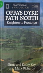 |
Distances
| From | To | Distance (m) | Ascent (ft) | Descent (ft) |
|---|---|---|---|---|
| Sodom | Rhuallt | 4.0 | 738 | 1001 |
| Rhuallt | Sea at Prestatyn | 8.1 | 1388 | 1667 |
| Sea at Prestatyn | Prestatyn station | 0.6 | 16 | 0 |
This makes a total distance of 12.7 miles, with 2142 feet of ascent and 2668 feet of descent.
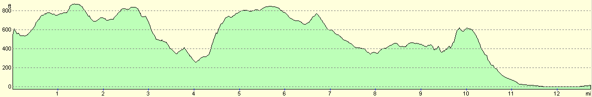
For more information on profiles, ascents and descents, see this page
Disclaimer
Please note that I take no responsibility for anything that may happen when following these directions. If you intend to follow this route, then please use the relevant maps and check the route out before you go out. As always when walking, use common sense and you should be fine.
If you find any information on any of these routes that is inaccurate, or you wish to add anything, then please email me.
All images on this site are © of the author. Any reproduction, retransmissions, or republication of all or part of any document found on this site is expressly prohibited, unless the author has explicitly granted its prior written consent to so reproduce, retransmit, or republish the material. All other rights reserved.
Although this site includes links providing convenient direct access to other Internet sites, I do not endorse, approve, certify or make warranties or representations as to the accuracy of the information on these sites.
And finally, enjoy your walking!
This walk was mentioned in the following routes:
| Offa's Dyke |
Nearby walks
| # | Title | Walk length (miles) |
|---|---|---|
| 415 | Rhos-on-Sea to Point of Ayr | 19.9 |
| 416 | Point of Ayr to Shotton | 17.9 |
|
|

|