Walk #768: Clwyd Gate to Bodfari
 |
 |
|
General Data
| Date Walked | 09/04/2007 |
| County | Clwyd |
| Start Location | Clwyd Gate |
| End Location | Bodfari |
| Start time | 09.06 |
| End time | 17.10 |
| Distance | 13.0 miles |
| Description | This was a verypleasant walk following Offa's Dyke over the Clwydian Hills. |
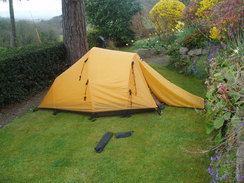
| Pack | Today I carried my 80-litre Macpac Glissade rucksack, containing a North Face Blue Kazoo sleeping bag, my North Face Westwind tent, clothes, waterproofs and other camping items, including cooking gear. |
| Condition | I am fairly fatigued after this walk and my calves continue to be tight, but aside from this I have had no problems. |
| Weather | The day started off sunny but with a very cold wind that caused me to put my coat on before I set off. As I started the descent down off the hills the clouds started to gather, and after walking through drizel on the tops it started to rain propery. The heavy shower lasted for about an hour, but it was soon repaled by warm sunshine. |
| OS map | Landranger number 116 (Denbigh & Colwyn Bay) |
 |
 |
|
 |
 |
|
Map of the walk
Maps courtesy of Google Maps. Route for indicative purposes only, and may have been plotted after the walk. Please let me have comments on what you think of this new format. For a detailed table of timings for this walk, please see the table file.
 |
 |
|
 |
 |
|
Notes
I awoke this morning very relaxed, and felt in absolutely no hurry to get up and do anything. Eventually I had a long shower and went out for breakfast to be greeted with some superb views over the plains to the west. Breakfast was a buffet-style affair, and I chatted to two other walkers as I ate and let the views sink in. It was tempting to go for another quick swim before I set off, but instead I slunk back to my room and watched some television, I was not in too much of a hurry as I am planning to camp about a mile away from Bodfari, and as there will be little to do at the campsite I do not want to arrive too early.
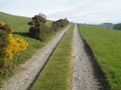
Eventually I started to pack up, and the other two walkers (who were heading off in the other direction to me) set off a few minutes before me. I thanked the lady who ran the motel - it had been a great place to stay and I had enjoyed myself in the pool and sauna immensely - and started off along the trail. Initially this followed the road, but it soon headed off along a track through a landscape filled with gorse. Due to the sunshine I had decided to start off without a fleece or coat on, but the chilly wind that had lapsed for the last couple of days was back with a vengeance and after a few minutes I was forced to stop to put my fleece on.
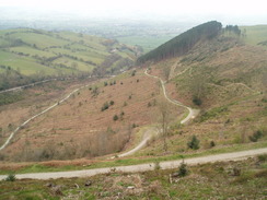
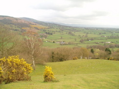
The track was level for the first mile or so and it was a very enjoyable walk, but the first climb of the day from Bwlch Crug-glas up towards Foel Fenlli was soon upon me. This was very steep and soon had me puffing; I was forced to take my time and stop occasionally, a fact that did not bother me unduly as it allowed me to take in the good views. The path did not go over the summit of the hill but instead followed the ramparts of the fort around the western flank, which again afforded me some good views. As soon as the path leveled out I soon recovered from the climb and enjoyed the walk, with the bank and ditch of the ramparts more than visible in places.
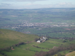
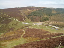
A steep descent took me down off the hill towards an obtrusive car park in Bwlch Penbarra, and passed several people walking up past me to visit the fort, which is apparently the highest of a chain of them in the Clywdian Hills. At the car park I stopped and took my rucksack off for a few minutes as I walked over to look at the nearby viewpoint. There was an information board here that pointed out various hills, and I believe that I could just make out the summit of Snowdon in the far distance. It was a really pleasant day for walking, and after basking in the sun for a few minutes a nearby refreshment van got my attention. A bacon sandwich was tempting but eventually I decided against it, and instead put my rucksack on and started off once more along the trail.
From the car park a wide track took me onwards, climbing so gently that I could spend most of my time looking at the views over to my left. After a short while the path was on the top of a wide ridge, rising and falling slightly as it headed northwards. There were many people out and about and the path seemed more like a motorway than a trail, and it is obviously a very popular place. A stiff climb took me up to the summit of Moel Fammau, and on the climb branches from conifers had been laid down to keep people from straying off the path and to allow the ground to recover.
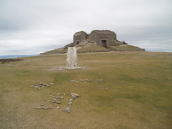
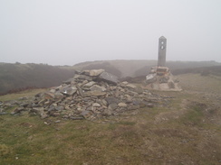
The summit of Moel Fammau was notable for several reasons. Firstly were the remains of the Jubilee Tower, built in 1810 to commemorate the Jubilee of George III and which fell down shortly afterwars. The resultant pile of stones looked fairly ugly, but I can see why it is popular - the views from around it were absolutely superb. A second reason the summit is notable is that there is a trig pillar at the summit from which there were more good views, and the final reason is that it is the old county top of Flintshire, and is therefore one that I could tick off my list. I walked around for a while but did not bother to climb the steps up to the top of the tower; the views were good enough from the base and the wind was starting to make me feel chilly; indeed, I had planned to stop here for lunch, but the wind forced me to continue on.
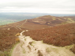
A fairly long descent followed, and on the way an elderly gentleman joined me and we chatted away for about a mile. He has done much walking in this area, and knew it like the back of his hand. It was nice to have the company, but before the path started to climb up towards the summit of Moel Dywyll he peeled off to the right. There were less people around hare than there had been nearer the previous summit, and I took this as a sign that many people could not be bothered walking very far from their cars. This was their loss as what followed was a pleasant stroll along a ridge, slowly falling and rising onto Moel Llys-y-coed, a walk that was not too difficult and very enjoyable.
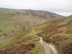
After a while the conical form of Moel Arthur became visible ahead of me, and this marked the part of the day's walk that I had not been looking forward to. Although the path on the flanks of Moel Arthur was lower than my current height, there was a very steep descent and ascent required to reach it. The descent itself was quite hard and I took my time, and by the road at the bottom I stopped and sheltered in a little hollow to have a break. I scoffed a chocolate bar in the sunshine, and after a while I decided to set off once again. From here the climb up the flanks of the hill did not seem too bad, and indeed ti was not; the ascent going the other way from the road would be much more strenuous, and before I knew it the gradient was slackening once again.
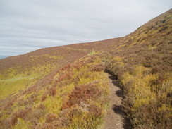
Another descent followed down to a road and yet another car park, after which the path climbed up westwards as it skirted the edge of some woodland up onto the large fort of Penycloddiau. This fort is much larger than any of the other Clywdian forts, and as I clambered across the moorland towards the ramparts it started to spit with rain. This was a surprise as no rain had been forecast, but as there were grey clouds all around I quickly stopped to put my coat on. This was a good thing as the cloud lowered as I climbed across the fort, and before I knew it I was in the cloud layer. As the wind was blowing from left to right my left-hand side was getting wet and my right-hand side was remaining dry, and it was only when I started the long descent down from the fort and I left the cloud layer that it started to rain properly.
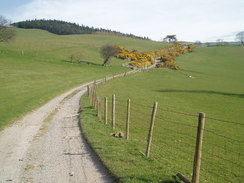
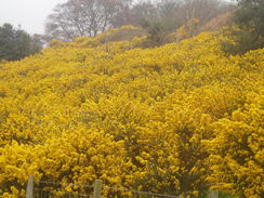
On the way down I passed a nice lady who was walking the trail from north to south, and it looked as though she was finding the weather and terrain hard. We chatted for a few minutes and I felt slightly sorry for her - I was in a very different situation, having done many trails before and being very near the end of this one. There were a few more people about on the descent, but it continued to rain as a long descent started down from the hill range, passing a little farmstead at Ty Newydd and skirting along a track around the flanks of a hill. Next came a descent across a field that was covered in gorse that was in flower, and a lovely buttery smell wafted over me as I walked past, and finally the rain stopped.
Eventually I reached the road in Bodfari, and I immediately nipped into the post office to get myself a little food for the evening and a paper to read. A little further along the road was the Downing Arms, and as it was still early I nipped in for a while and was delighted when I saw that they had Abbot. I ordered a pint and a packet of crisps, and as my wallet was buried inside my coat I had to take my rucksack off in order to get it. Someone started humming the striptease theme tune, and I twirled my mapcase around in time, accidentally spraying one of the locals with water off it before pulling my coat open in two flashy moves.
The locals seemed to like this entrance and I sat down to sup my drink and have a look through the paper. Before long a group of walkers came in, and we started chatting for a while. When I said that I was camping at Fron Haul, a mile away up the hill, they started waxing lyrically about the food served there, and I started to feel upset that I was camping out rather than inside the house. By the time that the first pint was finished it was still early, so I nursed another pint for a while before putting my rucksack on and saying goodbye to the people in the pub. Outside I passed a group of people who were walking the half of the trail north from Knighton (they had down the first half from Chepstow the previous easter), and discovered they were staying at the same place as me.
A long haul ensued uphill, initially along a lane before heading off along footpaths. This skirted the flanks of the hill fort at Moel y Gaer before continuing on to meet a road. It was steep in places and I took my time, but the sun was out once again and I was continuing to dry out after the rain of the early afternoon. On a stile near the road I came across a hat that I recognised as bing Gary's, and I picked it up and carried it with me - one of the walkers in the other direction told me that he had lost it yesterday.
At the road I asked a homeowner where Fron Haul was, and he pointed me in the right direction. The lady who ran the place was very nice, and we chatted for a while before I slowly started putting my tent up in the sunshine, in a garden that was only just big enough for me to erect my tent (I could have orientated it differently, but I wanted to have my head uppermost),.
After a while the other walkers arrived from the pub, and the owner invited me in for a cup of tea with them. It was an enjoyable albeit brief chat, after which I had a shower and retired back to my tent and read the paper from cover to cover. It was tempting to go down to the pub for a meal as the food is meant to be particularly good, but I want to have a very early start in the morning and therefore I went to bed early, managing to drop off to sleep as soon as it got dark.
 |
 |
|
 |
 |
|
Directions
| The walk is covered in detail in the Offa's Dyke National Trail Guide North (Knighton to Prestatyn), by Ernie and Kathy Kay, and Mark Richards, ISBN 1-84510-976-6 published by Aurum Press Ltd. Click on the image to the right to go to the Amazon page for the book. | 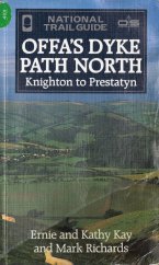 |
Distances
| From | To | Distance (m) | Ascent (ft) | Descent (ft) |
|---|---|---|---|---|
| Clwyd Gate | Moel Famau | 4.3 | 1483 | 653 |
| Moel Famau | Moel Arthur | 2.8 | 397 | 1096 |
| Moel Arthur | Bodfari | 4.9 | 856 | 1811 |
| Bodfari | Sodom | 1.0 | 525 | 138 |
This makes a total distance of 13.0 miles, with 3261 feet of ascent and 3698 feet of descent.
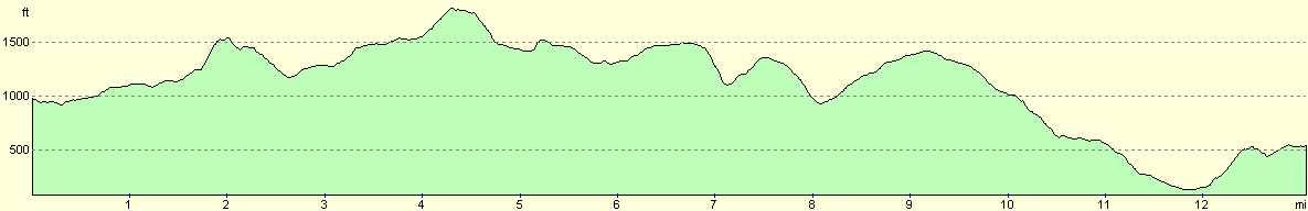
For more information on profiles, ascents and descents, see this page
Accommodation
I spent the night at Fron Haul,Sodom, Bodfari, Denbighshire LL16 4DY. Telephone (01745) 710301. This was a small campsite attached to what is apparently a superb B&B; the owner was very friendly and made me a cup of tea after I arrived, even though I was camping.
 |
Disclaimer
Please note that I take no responsibility for anything that may happen when following these directions. If you intend to follow this route, then please use the relevant maps and check the route out before you go out. As always when walking, use common sense and you should be fine.
If you find any information on any of these routes that is inaccurate, or you wish to add anything, then please email me.
All images on this site are © of the author. Any reproduction, retransmissions, or republication of all or part of any document found on this site is expressly prohibited, unless the author has explicitly granted its prior written consent to so reproduce, retransmit, or republish the material. All other rights reserved.
Although this site includes links providing convenient direct access to other Internet sites, I do not endorse, approve, certify or make warranties or representations as to the accuracy of the information on these sites.
And finally, enjoy your walking!
This walk was mentioned in the following routes:
| Offa's Dyke |
Nearby walks
| # | Title | Walk length (miles) |
|---|---|---|
| 767 | Llangollen to Clwyd Gate | 15.5 |
|
|

|