Walk #767: Llangollen to Clwyd Gate
 |
 |
|
General Data
| Date Walked | 08/04/2007 |
| County | Powys, Clwyd |
| Start Location | Llangollen |
| End Location | Clwyd Gate |
| Start time | 09.23 |
| End time | 16.33 |
| Distance | 15.5 miles |
| Description | This was a very pleasant day's walk following Offa's Dyke path as it headed over moorland and into the Clywdian hills. |
| Pack | Today I carried my 80-litre Macpac Glissade rucksack, containing a North Face Blue Kazoo sleeping bag, my North Face Westwind tent, clothes, waterproofs and other camping items, including cooking gear. |
| Condition | I am fairly tired after this walk, but have no significant problems to report. |
| Weather | Today was a mixture of sunshine and cloud, with some fairly gusty winds at periods. |
| OS map | Landranger number 117 (Chester & Wrexham, Ellesmere Port) and Landranger number 116 (Denbigh & Colwyn Bay) |
 |
 |
|
 |
 |
|
Map of the walk
Maps courtesy of Google Maps. Route for indicative purposes only, and may have been plotted after the walk. Please let me have comments on what you think of this new format. For a detailed table of timings for this walk, please see the table file.
 |
 |
|
 |
 |
|
Notes
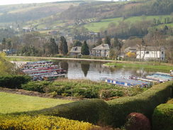
I managed to get a good night's sleep last night, and woke up in time to watch the start of the grand prix at 08.00 before going for a delicious breakfast at 08.30. I absent-mindedly continued watching it as In got changed into my walking gear and packed, but before the end I headed out of the B&B and started on the long ascent along roads to the point where I had left Offa's Dyke path yesterday. Although the gradient was slight my cold legs noticed the ascent, and I let the splendid views of the crags ahead distract me as I climbed.
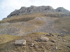
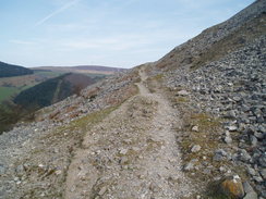
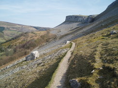
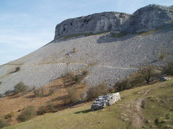
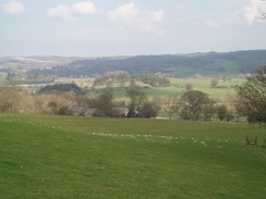
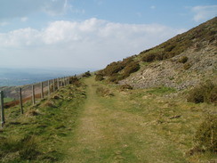
The road junction was soon reached, and I continued along it in the sunshine below some magnificent crags, to the sound of sheep and lambs bleating away in the fields below as the road started to descend. Before long, however, the path headed off, and was soon skirting along on what must be one of the most spectacular sections of the trail. The path was narrow and rocky as it headed around the hillside with the crags overhead, and I dawdled along and just enjoyed the views with an accompaniment of yet more bleating from sheep in the valley below. I really cannot describe well enough the magnificence of this stretch, and the views alone made it a highlight of the entire trip for me. In places there were patches of scree that needed to be crossed, but the thousands of people who had walked the path before me had made this task remarkably easy and problem free.
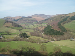
Unfortunately this section had to come to an end, and it did so as the path left the crags behind and turned to make a more northeasterly course towards the road at World's End. After the spectacular scenery of a few minutes before this stretch of path was a a bit of a let-down, but that is hardly being fair; the views down into the valley on my left were still good, and the path was even easier to follow. At World's End a road was met, and a stream crosses the road in a long ford; it is a noteworthy spot, and I can see why many people come up here to drive this stretch of road.
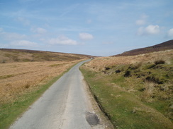
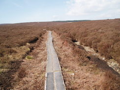
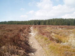
There then followed a long, and at first steep, climb through woodland northwards. The steep section of the ascent ended by a car park at the edge of the trees and after this the gradient slackened as some pretty moorland was entered. It was still climbing, however, and the views soon started to open out as a couple of cars and cyclists came roaring past me. After about a mile the trail left the road and headed northwestwards across some moorland, and this was a stretch of path that I had been looking forward to. However it had been spoilt slightly as for almost the entire way there was a boardwalk consisting of old railway sleepers, a surface that was undoubtedly easier to walk on but also meant that, in this dry sunny weather, the walk was more boring than it need have been.
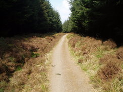
Eventually the path reached a summit and entered some trees, and I followed it as the path started to descend steeply, losing almost all of the height that I had gained so far during the day in much less distance. On the way I occasionally saw brief flashed as cyclists went past, and I could hear them going along some of the various tracks that ran through the forest. I had not put my water bottle into the pocket at the back of my rucksack very well, and as I descended it suddenly dropped it in a particularly dark stretch of forest. There was no way that I could put it back in without taking my rucksack off, so I took it off and sat down for a few minutes.
It was not the most salubrious place to rest, and therefore I soon shouldered my rucksack and continued on down the steep path. As it descended it became narrower and darker, and in one place there were some segments of boardwalk and wooden steps next to the path that had not been walked on for some time - the path was now a few feet away from them. The path emerged from the trees and passes an old farm; it was nice to be out of the dark woodland, and I felt good as the path continued to descend down to cross a stream and finally reach the A525 road.
Once across the road a path took me up to another road, and I followed this through to Pen-y-stryt before diverting off southwards for a couple of hundred yards to reach the Crown Inn. On the way I passed a restaurant, but this did not seem as tempting as the pub and so I walked he extra few yards and ordered my usual two pints. It seemed like a good opportunity to take my boots off and rest my feet, and as there was no-one else in the bar area that I was sitting in I felt that I could do this with no problems. There was a pool table nearby, and I walked around, stretching my legs and bouncing the cue ball off the cushions to while away some time.
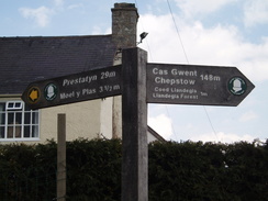
After leaving the pub it only took me a few minutes to get back to the trail at a road junction, and I followed the road down towards the little village of Llandegla. This was where Gary had spent last night, and suddenly I felt glad that I had cut yesterday short - the spectacular walk this morning would have been nowhere near as good if I had pushed myself to walk further. The post office was only open until midday on a Sunday so I could not purchase any snacks, and at a junction there was an Offa's Dyke waypost that showed that Prestatyn was only 29 miles away - seeing this made me feel very happy, as I have two days in which to walk the distance.
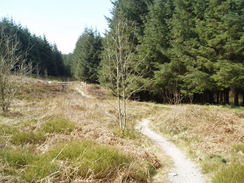
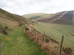
From Llandegla the path initially crossed the valley floor with a little stream on the left, before crossing this stream on a footbridge and heading up towards a road. On the way it passes some caves - I saw the entrance to one on my right, and it is a sign that we are back in limestone country; the last time (as far as I am aware) being the start of the walk in Chepstow. From the road a farm track took me westwards, slowly climbing as it headed towards the farm buildings. Before they are reached, however, the trail has been diverted to bypass them, and the path climbed as it crossed a series of stiles. Several of these were hardly of a suitable quality for a National Trail and were difficult to cross with a heavily-laden rucksack, and before the last one was reached I was more than fed up with them.
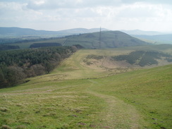
Once across the last stile a short stretch of path took me on towards a road, passing a little farm on the left that had some very ruined barns in it. This road then headed north, and a little car park a track continued up, heading towards a large mast from where there were some fairly spectacular views in the cloudless skies. A path continued on from the mast and there was a little drop, but this was followed by a steep climb up onto the flank of Meol y Plas, and again there were some very good views to be had, although, as was the case for the rest of the day, the path spurned the hill tops and instead skirted some way below them, and I was in no mood to divert off to climb them.
When I had been planning this trip I had more or less ignored this northern stretch of the trail, believing (rightly) that I should concentrate on the southern stretch that I would be doing first. Therefore the scenery and severity of the Clwydian range of hills came as a surprise, and I started looking more closely at the route for tomorrow. Having said this the views more than compensated for the climbs, and as the path descended to a little pass that held a track that led to Llanarmon-yb-Ial, where I had considered camping for the night I decided that I was really enjoying this walk.
A little track led on, climbing slightly as it headed around the flank of Moel Llanfair, and this was a very pleasant stretch of walk until it started to climb steeply up towards Moel Gyw. This ascent was along a good track but I found that I had little energy left in my legs; ahead of me I could see two figures climbing up towards the summit of the hill, and I envied them their light packs and the views that they must be getting.
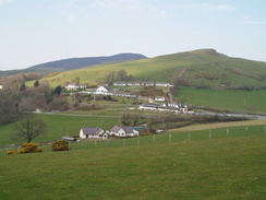
Much to my relief the trail did not visit the top of Moel Gyw but instead descended very slowly along the western flank of the hill; as soon as the gradient slackened I managed to speed up, and although the views were not as good as they had been I felt really good, although my legs were still tired. Once past Moel Gyw the path headed off westwards, climbing a little hill before I got my first view of the white motel where I would be spending the night. It was a quick descent, and before I knew it I was booking myself in.
I was offered an evening meal, and as the complex had a swimming pool and sauna I asked if they had any swimming trunks that I could buy (I never take swimming gear with me when I am walking for the obvious reasons). Amazingly the woman said that they kept swimming costumes for visitors, and that I could borrow a pair! I therefore went into my room, had a good shower and rested for a while before heading off to the pool. In the pool there was another walker, one of two men from the southwest who were doing a third of the trail from Prestatyn to Welshpool in a short trip. I chatted to him for a while in the sauna, and then him and his friend over a pleasant dinner. It was nice talking to other walkers, and we each swapped stories of the stretches of trail to come. As days go, this had been a superb day.
 |
 |
|
 |
 |
|
Directions
| The walk is covered in detail in the Offa's Dyke National Trail Guide North (Knighton to Prestatyn), by Ernie and Kathy Kay, and Mark Richards, ISBN 1-84510-976-6 published by Aurum Press Ltd. Click on the image to the right to go to the Amazon page for the book. The exception to this is the beginning of the walk; from the bridge over the river in the centre of Llangollen turn right along the A539 road for a few yards to the Bridge End pub, and then turn left up a road that crosses the canal. After the canal turn left up Dinbren Road, and follow this as it heads roughly northwards with the hill of Dinas Bran occasioanlly visible to the east. The road climbs up past Dinbren Hall, and at the next road junction turn right to continue climbing uphill. After a little uder a mile there is another road junction near Dinbren-uchaf, where Offa's dyke path is met. | 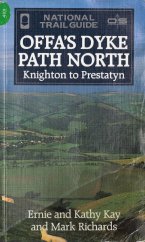 |
Distances
| From | To | Distance (m) | Ascent (ft) | Descent (ft) |
|---|---|---|---|---|
| Llangollen | Road junction | 1.9 | 604 | 43 |
| Road junction | Llandegla | 7.6 | 1686 | 1699 |
| Llandegla | Clwyd Gate | 6.0 | 1266 | 1112 |
This makes a total distance of 15.5 miles, with 3556 feet of ascent and 2854 feet of descent.
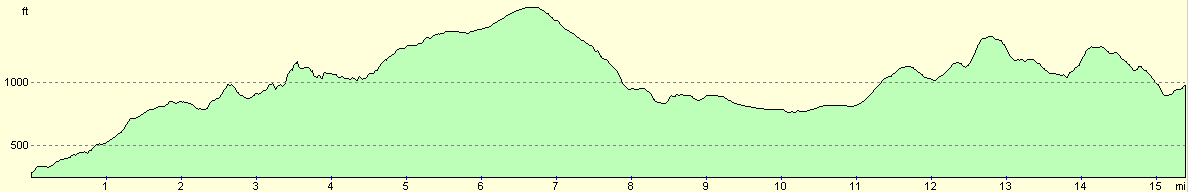
For more information on profiles, ascents and descents, see this page
Accommodation
I spent the night at the Clwyd Gate Motel, Mold Road, Llanbedr D.C., Ruthin, Denbighshire, LL15 1YF. They can be contacted by telephone on (01824) 704444 or on the web at http://www.clwydgatemotel.co.uk. A double room (there were no singles available) cost me �45, and were good enough for the price. The real bonus, however, was the swimming pool and sauna that they kindly leant me some swimming shorts so that I could use.
 |
 |
|
 |
 |
|
Disclaimer
Please note that I take no responsibility for anything that may happen when following these directions. If you intend to follow this route, then please use the relevant maps and check the route out before you go out. As always when walking, use common sense and you should be fine.
If you find any information on any of these routes that is inaccurate, or you wish to add anything, then please email me.
All images on this site are © of the author. Any reproduction, retransmissions, or republication of all or part of any document found on this site is expressly prohibited, unless the author has explicitly granted its prior written consent to so reproduce, retransmit, or republish the material. All other rights reserved.
Although this site includes links providing convenient direct access to other Internet sites, I do not endorse, approve, certify or make warranties or representations as to the accuracy of the information on these sites.
And finally, enjoy your walking!
This walk was mentioned in the following routes:
| Offa's Dyke |
Nearby walks
| # | Title | Walk length (miles) |
|---|---|---|
| 766 | Carreg-y-Big to Llangothlen | 15.3 |
|
|

|