Walk #237: Runswick Bay to Robin Hoods Bay
 |
 |
|
General Data
| Date Walked | 16/10/2002 |
| County | North Yorkshire |
| Start Location | Runswick Bay |
| End Location | Robin Hood's Bay |
| Start time | 08.10 |
| End time | 15.58 |
| Distance | 14.9 miles |
| Description | This was a lovely clifftop walk following the Cleveland Way southeastwards, passing through the town of Whitby on the way. |
| Pack | Today I carried my 30-litre Karrimor HotRock rucksack, which was filled with my packed lunch, waterproof coat, water bottle and a couple of spare shirts, together with the usual assortment of odds and ends. |
| Condition | I feel absolutely fine after this walk - I have no problems to report aside from a slight fatigue. |
| Weather | The weather today was blustery, with a strong wind being the main factor throughout the day. There were periods of occasional rain, although these were infrequent and fairly light. There were also some sunny periods, but the wind made these not as enjoyable as they should have been. |
| OS map | Landranger number 94 (Whitby & Esk Dale, Robin Hood's Bay) |
 |
 |
|
 |
 |
|
Map of the walk
Maps courtesy of Google Maps. Route for indicative purposes only, and may have been plotted after the walk. Please let me have comments on what you think of this new format. For a detailed table of timings for this walk, please see the table file.
Notes
I woke up this morning to a feeling that it was going to be a good day's walk, and I was very much looking forward to getting started on the walk along the cliffs. After the industry of the northeast it was nice to be firmly embedded in the North Yorkshire Moors, a far more scenically interesting area.
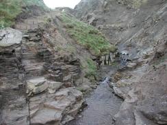
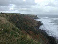
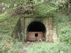
I started the day by descending down the steep road that leads down from the campsite to the beach by Runswick Bay. This is a fairly spectacular little village that nestles closely by the sea, and it was a fairly picturesque village. Instead of following the Cleveland Way, which runs immediately behind the beach, I decided to follow the beach as it was low tide. When I got near to Hob Holes, however, it became obvious that I would have to leave the beach and so I joined the Cleveland Way where some steps lead up onto the top of the cliffs. What followed was a superb few miles along the clifftop, with some lovely views to be had back along the cliffs. In places the path passes very close to an old railway line, and the portals of a tunnel were clearly visible to the east of Kettleness. Kettlness village itself slipped into the sea one night in 1829 - a strange fate for an entire village! Eventually the path descended down Deepgrove Wyke to meet the old railway line, which then carries on through the old Sandsend Alum Quarries, a spectacular place with spoil heaps everywhere, right on the edge of the cliff. Eventually I descended down to Sandsend, where I found a shop for some refreshments, and started the short walk into Whitby.
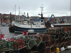
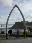
I met Sam on the descent down into the harbour of Whitby, and she was quite excited - she had been looking around the town for a couple of hours and had fallen in love with it. As soon as I descended past a curious arch made out of whale jawbones and got down to the main part of the town I found it hard too disagree - the town has a certain charm and is very picturesque. The harbour is also exceedingly nice, and there were many fishing boats tied up, with piles of lobster pots scattered around the quayside. After looking around for a while and nipping into a nearby walking shop we decided to nip into a pub in the centre for a quick drink. Even the views over the quay from inside the pub were nice, and the atmosphere added to my happy memories of the town. The town's most famous inhabitant was Captain Cook, who lived and sailed from the port from 1746, aged 18. At the time Whitby was England's seventh largest port, which is difficult to believe when you see it nowadays.
It would have been easy for me to spend the entire day in Whitby and it was indeed tempting to do so, but it would have been a shame to end the walk so early and so I started the short but steep ascent up the 199 steps of Church Street to the ruins of Whitby Abbey. This costs money to enter and I was loath to do so for the short period that I could go in for, and a tall wall obstructed views of the ruins. Fortunately in a couple of places I could just about look over this, and I managed to sneak a couple of photographs of the ruins, which are very impressive from a distance. Between the ruins and the clifftop was an archaeological dig that was trying to record what was under the ground before the next cliff fall; the cliffs here are eroding quickly and apparently there is a danger that some important archaeological information will be lost forever.
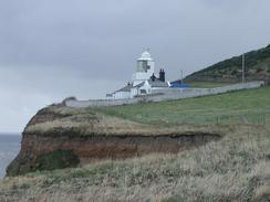
From the abbey the path kept to the top of the cliffs, which are rapidly eroding, through a caravan park and then headed onto the compact lighthouse at Beacon Hill. The going was easy and there were not too many gradients to slow me down, so I made good time as I headed along the path to Maw Wyke Hole, where the Coast-to-Coast Path meets the sea before finally ending at Robin Hood's Bay. The coast to coast starts off at St Bees Head in Cumbria, and I wondered how many miles and months it would take me to reach there - certainly more than the 187-miles the official path takes!
Towards the end of the walk I met a couple who told me that they had seen Sam at a different campsite to the one that we had agreed to meet at; this confused me, and about a mile and a half later another man told me that he had seen Mervan at the campsite, which was a certain distance away from where we had booked in to stay. I tried phoning Sam up to ask her where she was, but she was out of range and I could not make contact. I continued walking along the cliffs towards the little village of Robin Hood's Bay, where we had agreed to meet, but my mind was concentrating more on where she was rather than the beautiful scenery in the area. Eventually I managed to get through to her on my mobile, and it turns out that she had changed campsites due to not liking the one that we were going to stay at. This settled my mind, and I could concentrate more on the scenery, which was beautiful. In a couple of places streams ran over the edge of the cliffs, and as the strong wind was coming in off the sea the water was being blown back up off the cliffs and covering me with a fine spray. As the sun was shining at the time this led to seeing rainbows in the spray, a beautiful sight that I had only ever seen before n Kinder Downfall in Derbyshire.
Sam met me near Ness point, and we walked down into Robin Hood's Bay together. It was a nice walk, and I enjoyed chatting to her as we descended down the path - sometimes it is easy to forget how much I miss having people around me as I walk. Fortunately so far on this trip I have never felt lonely, even when in the most wild of places, and I have always known that Sam will be there for me at the end of the day.
Directions
This walk follows the Cleveland Way, a National Trail. The directions for this stretch of the walk can be found in the Ordnance Survey National Trail Guide 3, Cleveland Way (ISBN 1-85410-606-6). This guidebook has many notes and 1:25,000 strip maps of the route, so there is little point in my replicating them.
Distances
| From | To | Distance (m) | Ascent (ft) | Descent (ft) |
|---|---|---|---|---|
| Runswick Bay | Whitby | 8.4 | 1453 | 1713 |
| Whitby | Robin Hood's Bay | 6.5 | 2077 | 1877 |
This makes a total distance of 14.9 miles, with 3530 feet of ascent and 3590 feet of descent.
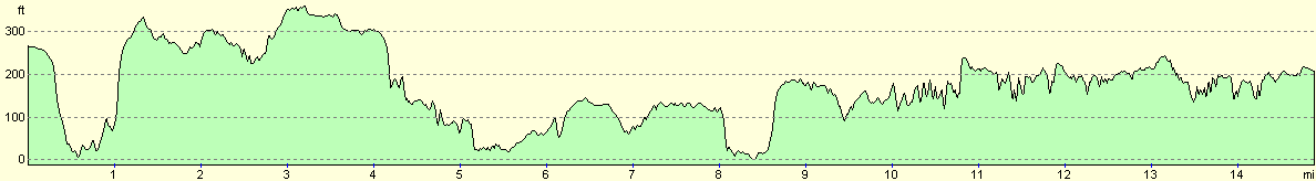
For more information on profiles, ascents and descents, see this page
Accommodation
We stayed at the Northcliffe Caravan Park, Bottoms Lane, High Hawsker, YO22 4LL, Tel. (01947) 880477, web at www.nothcliffe-seaview.com and email enquiries@northcliffe-seaview.com. This site cost us ten pounds for the night, and they allowed us to park on a superpitch for no extra cost, which saved us a few pounds. The site itself was quite nice and was clean and tidy, although the shop shut at 14.00, which was annoying as we wanted to buy a bottle of wine.
Disclaimer
Please note that I take no responsibility for anything that may happen when following these directions. If you intend to follow this route, then please use the relevant maps and check the route out before you go out. As always when walking, use common sense and you should be fine.
If you find any information on any of these routes that is inaccurate, or you wish to add anything, then please email me.
All images on this site are © of the author. Any reproduction, retransmissions, or republication of all or part of any document found on this site is expressly prohibited, unless the author has explicitly granted its prior written consent to so reproduce, retransmit, or republish the material. All other rights reserved.
Although this site includes links providing convenient direct access to other Internet sites, I do not endorse, approve, certify or make warranties or representations as to the accuracy of the information on these sites.
And finally, enjoy your walking!
This walk was mentioned in the following routes:
| My walk around the coastline of Britain |
Nearby walks
| # | Title | Walk length (miles) |
|---|---|---|
| 236 | Redcar to Runswick Bay | 17.2 |
| 238 | Robin Hood's Bay to Cayton Bay via Scarborough | 18.7 |
| 961 | Cleveland Way: Kildale to Boulby Cliffs | 22.9 |
|
|

|