Walk #236: Redcar to Runswick Bay
 |
 |
|
General Data
| Date Walked | 15/10/2002 |
| County | Cleveland, North Yorkshire |
| Start Location | Redcar |
| End Location | Runswick Bay |
| Start time | 08.05 |
| End time | 15.50 |
| Distance | 17.2 miles |
| Description | This walk was a drastic difference to those of the last few days; a four mile beach walk was followed by a walk along cliffs following the Cleveland Way. This was a superb walk in less than superb weather. |
| Pack | Today I carried my 30-litre Karrimor HotRock rucksack, which was filled with my packed lunch, waterproof coat, water bottle and a couple of spare shirts, together with the usual assortment of odds and ends. |
| Condition | I feel absolutely fine after this walk, with no problems or blisters to report. |
| Weather | The major feature of today's walk was the weather, which was very windy, especially on the exposed cliff tops. For most of the time this was a head wind, which in places made progress frustratingly slow as I had to make sure my footing was good before battling on against the wind. For the first hour or so there was a torrential downpour whilst I walked through Redcar; fortunately the wind helped my waterproofs to dry off in what must be record time. Although the wind remained later on the rain stopped, and at times the sun even tried to break through, although mostly there was thick cloud overhead. |
| OS map | Landranger number 93 (Middlesbrough, Darlington & Hartlepool) and Landranger number 94 (Whitby & Esk Dale, Robin Hood's Bay) |
 |
 |
|
 |
 |
|
Map of the walk
Maps courtesy of Google Maps. Route for indicative purposes only, and may have been plotted after the walk. Please let me have comments on what you think of this new format. For a detailed table of timings for this walk, please see the table file.
 |
 |
|
 |
Notes
Today feels as if I have entered a different world. The last few days had consisted of walking around some quite industrial areas, but today I landed slap-bank in some lovely coastal walking, mainly following the Cleveland Way. The difference made for a slight culture shock, but it was a nice change nonetheless. It was very nice to be leaving the industrial northeast behind me, and to be entering an area of beauty, the North Yorkshire Moors.
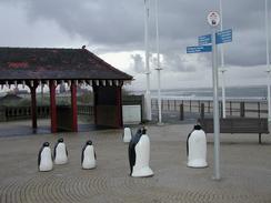
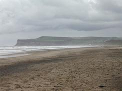
I found Redcar to be quite a neat little town, and it seemed to be quite well cared for. I was amused to see a group of sculpture penguins gathered around a signpost as if they were trying to work out where to go. It is strange how little touches such as this can improve how you feel about the place, but after I saw them I got the feeling that Redcar is a jovial little place. The town is home to the oldest surviving lifeboat in the country, the Zetland, which was built in 1800. The lifeboat is believed to have saved at least 502 lives, and was built only ten years after the first ever lifeboat, aptly called the Original. From Redcar to Saltburn-by-the-Sea I walked along the beach as it was low tide, although there are paths along the tops of the cliffs that can be used instead. As a result of walking along the beach I did not really get to see Marske-by-the-Sea, most of which was perched on top of the cliffs above me.
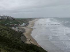
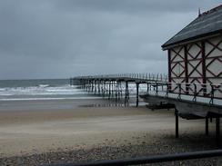
The beach ended at Saltburn-by-the-Sea, and I walked along the beach until I reached the pier, which is half its original length after it was decapitated by a ship early in the twentieth century. I quite liked Saltburn; the pier was attractive, it had a cliff railway near the pier and there were some nice buildings by the seafront. It is also the place that the Cleveland Way (a National Trail) meets the coast, and I will be following that path for the next few days until it ends near Filey. As I climbed up the steep hill that leads east out of the village I could not help but look back down over the village; it was nice to have a beautiful view after all the industry that I have seen over the last few days.
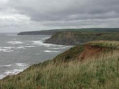
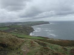
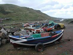
I really enjoyed the high cliffs that followed, and the path was exceptionally easy to follow as it wound its way up to Hunt Cliff (which is believed to have been the site of a Roman signal station) and eventually down into the village of Skinningrove. This village was vastly different to Saltburn - it obviously had an industrial path, where Saltburn was built solely for tourists, and the difference showed. Whereas parts of Saltburn were elegant, Skinningrove was rugged and had a slight frontier feel to it.
When I got to Skinningrove I really felt like I needed a drink, and so I asked a lady who was out walking her dog whether there was a pub nearby. She directed me about a hundred yards into the village, where I found a pub. I had a look around, and the main door was locked but a side door was open, with a fruit machine blocking the way in. I could hear voices coming from inside, and so I leant through and asked if they were open. I got a reply stating that they were not open until 16.00, but since they were in at the moment (taking delivery of the fruit machine), they kindly let me in and I had a pint of Worthington's. They asked me what I was doing, and when I told them they seemed to think that I was insane, which is a common response people give me and one that I cannot really argue with! I chatted to the landlord about the local area and how badly it had been effected by the closure of the local mining industry (the Loftus ironstone mine in the village is now a museum), and I must admit I felt like it was a terrible shame - he spoke of a community that used to have pride, but which had suffered a nearly mortal blow after the closure of the mine.
Once I left the pub I felt warmed up by the kindness and good conversation in the pub, and so I found the climb up the cliffs to Rock Cliff (the highest cliffs in Eastern England at 666 feet), and on down into Boulby. Here the view is dominated by the Boulby Potash mine, the main shaft of which is 4,000 feet deep and which was completed in 1973. Although the mine was unsightly I was quite happy to see it, as it must provide work for some of the people in Skinningrove.
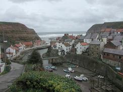
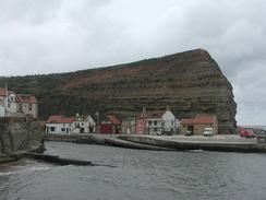
By the time it got to 14.00 I realised that I still had not had any lunch, so I decided that I would stop when I got to Staithes and have lunch there. This was a very fortunate decision, as the village was extremely picturesque, nestling in a gorge cut through the cliffs by a little beck. On the way down into the village I had a quick chat with a gent who was out in his garden, and we talked about that typical English topic, the weather. I stood outside his house to take a photo down into the village, which is built up on many different levels up the hillside, when I noticed that the cliff outside his house had a few gnomes climbing their way up it! The village itself was very nice, with narrow streets and beautiful little cottages - it was the most perfect little fishing village that I have passed on the journey so far. The rest of the stroll from Staithes to Runswick Bay took me past the pretty little hamlet of Port Mulgrave, which is perched high up on the cliffs and which gave me some expansive views out to sea and back along the cliffs.
I have two things to celebrate tonight; firstly I have walked further in this trip than I have in any other trip (261 miles), and secondly I have now walked further this year than I have in any other year (980 miles against 973 miles in 2000). This all feels very good, and it is a nice sign that I am not really suffering from the travails of the walk so far. I am currently feeling really quite positive about the walk so far, and I am certainly looking forward to the next few days, when I should reach the 1,000 mile mark for the year.
Directions
This walk starts off at the Redcar Beach Holiday Park, which is next to the beach in Coatham, just to the west of Redcar. Leave the caravan park and turn right to walk eastwards along the road until a roundabout is reached, and then turn left to head northwards up to the beach in Coatham. Once on the beach turn to the right and follow it eastwards past Coatham Rocks and onwards into Redcar; her I joined the promenade and walked along that rather than the beach, passing the Tourist Information Office and eventually reaching a roundabout with the A1085 road. If the tide is out walk southeastwards along the sands; otherwise you will have to walk along the A1085 on top of the low cliffs to Marske-by-the-Sea, and then take footpaths into Saltburn-by-the-Sea. The beach route follows the beach under Marske-by-the-Sea and on to Saltburn-by-the-Sea, and here I climbed up to join the promenade past the pier.
In Saltburn-by-the-Sea the route that I took for the rest of the day follows the Cleveland Way, a National Trail. The directions for this stretch of the walk can be found in the Ordnance Survey National Trail Guide 3, Cleveland Way (ISBN 1-85410-606-6). This guidebook has many notes and 1:25,000 strip maps of the route, so there is little point in my replicating them.
Distances
| From | To | Distance (m) | Ascent (ft) | Descent (ft) |
|---|---|---|---|---|
| Redcar | Saltburn-by-the-Sea | 5.8 | 39 | 43 |
| Saltburn-by-the-Sea | Skinningrove | 3.5 | 1220 | 1227 |
| Skinningrove | Staithes | 4.7 | 1093 | 1119 |
| Staithes | Runswick Bay | 3.2 | 640 | 410 |
This makes a total distance of 17.2 miles, with 2992 feet of ascent and 2799 feet of descent.
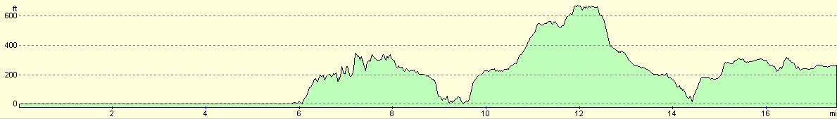
For more information on profiles, ascents and descents, see this page
Accommodation
We stayed at the Runswick Bay caravan and camping park, on Hinderwell Lane, Runswick Bay, telephone 01947 840997. This was a lovely little caravan park that was well appointed. The lady who ran it let us stay for free because I was raising money for charity, which was an act of kindness that I shall not forget.
Disclaimer
Please note that I take no responsibility for anything that may happen when following these directions. If you intend to follow this route, then please use the relevant maps and check the route out before you go out. As always when walking, use common sense and you should be fine.
If you find any information on any of these routes that is inaccurate, or you wish to add anything, then please email me.
All images on this site are © of the author. Any reproduction, retransmissions, or republication of all or part of any document found on this site is expressly prohibited, unless the author has explicitly granted its prior written consent to so reproduce, retransmit, or republish the material. All other rights reserved.
Although this site includes links providing convenient direct access to other Internet sites, I do not endorse, approve, certify or make warranties or representations as to the accuracy of the information on these sites.
And finally, enjoy your walking!
This walk was mentioned in the following routes:
| My walk around the coastline of Britain |
Nearby walks
| # | Title | Walk length (miles) |
|---|---|---|
| 234 | Blackhall to Billingham via Hartlepool | 20.5 |
| 235 | Billingham to Redcar | 12.3 |
| 237 | Runswick Bay to Robin Hoods Bay | 14.9 |
|
|

|