Walk #234: Blackhall to Billingham via Hartlepool
 |
 |
|
General Data
| Date Walked | 13/10/2002 |
| County | Durham, Cleveland |
| Start Location | Blackhall |
| End Location | Billingham |
| Start time | 09.15 |
| End time | 16.56 |
| Distance | 20.5 miles |
| Description | This was a walk of two halves; a nice walk along cliffs and beaches to Hartlepool was followed by a long and boring walk in the rain down towards a bridge over the Tees near Middlesbrough. |
| Pack | Today I carried my 30-litre Karrimor HotRock rucksack, which was filled with my packed lunch, waterproof coat, water bottle and a couple of spare shirts, together with the usual assortment of odds and ends. |
| Condition | I am absolutely fine after this walk, and have no problems at all to report. I am not even very fatigued, and could easily have walked further if the need had arisen. |
| Weather | Today started off bright and sunny with scarcely a cloud in the sky; a drastic difference to the way yesterday ended. There was not much wind, and the first part of the walk along the beach was highly enjoyable in the sun. As th4e day went on the cloud started to form overhead, and the last part of the walk was in persistent light rain that got me fairly wet. It is a shame that a day that started off so promising still ended up in my getting wet. |
| OS map | Landranger number 93 (Middlesbrough, Darlington & Hartlepool) |
 |
 |
|
 |
Map of the walk
Maps courtesy of Google Maps. Route for indicative purposes only, and may have been plotted after the walk. Please let me have comments on what you think of this new format. For a detailed table of timings for this walk, please see the table file.
Notes
This was one of the days walking on the entire trip that I had been dreading, as I was entering yet another heavily industrialised area. Fortunately it did not prove to be as bad as I was expecting, and the first part of the walk to Seaton Carew was pleasant enough. The second half towards Middlesbrough, however, would not go on the list of my favourite places to walk.
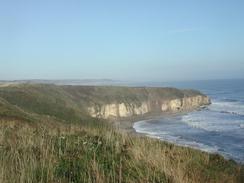
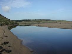
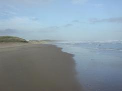
The first leg of the walk took me back to the clifftop path that wends its way southeastwards, cutting inland around a ravine before entering the caravan park at Crimdon Park. The cliffs slowly become lower, and eventually they descend to meet Crimdon Beck. This was a lovely little spot, and the beck looked beautiful in the morning sunlight. There then followed a nice stroll along the North Sands, the cliffs behind which helped hide Hartlepool from view. I could not help but see the large pier that juts a long way out to sea and serves a large factory on top of the cliffs, although this was not a bad sight and was actually quite pleasing to the eye in a strange way.
I was surprised by how nice Hartlepool was. I had always imagined it as being a typically dark area of the northeast, but it turned out to be surprisingly neat and tidy. Initially I walked from the beach past Parton Rocks and then took roads and paths that headed around the little headland called, well, the Headland. The city centre itself was quite nice, and the area around the Historic Quay was very well done (although I did not go inside to see the ships as it appeared to cost money to enter). I even found the road walk through the town to be interesting, which is more than I could say for the road walking I had to do later in the day. Near the Historic Quay I tried to go into a pub, but for the first time on the trip I was refused entry as I was too scruffy - I believe that there was a football match going on in the area, which may have had something to do with it.
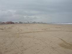
From Hartlepool I walked south along the promenade to Seaton Carew, and then joined the beach beside Hartlepool Bay. This was a surprisingly rewarding walk, with some reasonable views out to sea and few signs of exactly how close I was to the large industrial complexes of the Tees. Eventually I reached the North Gare Breakwater, and this meant the end of the scenic section. I had no choice but to walk inland along a track, and then join a footpath that led inexorably to the A178 road.
There were big problems with route planning today as the entire eastern side of the Tees estuary from Teesmouth southwards is heavily industrialised, which meant that I could not walk close to the river. This forced me to walk along main roads, mainly the A178, which did not have a pavement. Fortunately traffic on this Sunday afternoon was light, which meant that I did not feel like my life was being too endangered. It may not have been endangered but that did not mean he walk was pleasant; I have no real wish ever to repeat this walk, and I do not often say that about a walk.
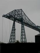
As I headed south down the A178 the Middlesbrough transporter bridge started to loom larger ahead of me. This fascinating structure is one of only two in Britain, the other being in South Wales (I shall pass it later on in the walk). Cars are takes across the Tees on a platform that is winched from side to side over a high crane-like structure. I did not get to see this in operation today, but tomorrow I shall be passing quite near it on the southern side of the river so I shall take a closer look.
When I reached the A178 / A1046 junction Sam phoned and we arranged to meet up. I was nearing the transporter bridge at the time and I was feeling fit, so I said that I would continue on along the A1046 until we met up. About twenty minutes later Sam phoned up and told me that she was at the bridge, but after a few minutes conversation I realised that she was on the south side, and not the north side! Another twenty minutes elapsed whilst I walked on for another mile or so before we eventually met up in a dark industrialised area between Billingham and Middlesbrough, complete with a pub that had signs outside advertising strippers. The KLF song 'It's grim up north' came into my head, and I had visions of dark Lowry paintings as I trudged along, and I could not wait to get into Mervan.
The weather today was a massive let down. The day started off sunny and bright, and the walk along the beach was beautiful. It seems that the weather was matching the scenery, however, because when I approached the long road walk through industrial areas it started to rain, sometimes just a light drizzle but at others much harder. It is a shame that a day that started off so promising became a letdown, but that is they way such things work.
Directions
This walk starts off at the A1086 road in Blackhall Rocks. Leave the A1086 and head east along a minor road that leads eastwards, soon heading under the railway line. When the road turns to the left on the other side of the line turn to the right and follow a track for a short distance, and then take a footpath that leads eastwards for a short distance to the top of the cliffs. When the cliffs are reached follow the footpath as it turns to the right and heads southeastwards; the path skirts around the top of a little valley before rejoining the clifftop and entering a large caravan park. Keep to the clifftop through the park, and the footpath eventually joins a track that leads down to Crimdon Beck.
Cross the Beck using the footbridge, and on the other side turn to the left to walk to the beach. Once on the beach to run to the right and walk southeastwards along it, passing under the supports of a large pier before reaching the southeastern end of the beach at Parton Rocks. Once the rocks are reached climb up onto the little promenade that runs along the top of the low cliffs. The promenade slowly curves around past the lighthouse in Headland and past Headland Pier to reach another lighthouse, which guards the entrance to Hartlepool Docks. When the promenade ends join the road and follow it around past the docks until it reaches the end of the A1048 road.
Join the A1048 road and follow it as it heads northwestwards past the docks. The road passes the junction with the A1049 road and curves to the left to reach a roundabout with the A179 dual carriageway. Head south down the A179, immediately passing under a railway bridge and continuing on for about half a mile to another roundabout. Continue straight on down the A889 road as it skirts past the marina; just before another roundabout is reached turn to the left and walk eastwards past the Historic Quay complex. On the eastern side of the complex join a cycle path that heads southeastwards to meet the sea by the beach, and then walk south along the promenade for two miles into Seaton Carew.
In Seaton Carew leave the promenade and drop down onto the beach, and follow this southeastwards until you reach the North Gare Breakwater, which guards the mouth of the River Tees. Once the breakwater is reached join a track that heads southwestwards to a car park, where you can turn to the left to head south for a kilometre down another track towards the power station. When another track leads off to the right take this track and follow it northwestwards for a little over a kilometre until it ends at the A178 road.
Turn left and follow the A178 road southwestwards for a few hundred metres to a roundabout with the B1277 road; continue straight on at this roundabout down the A178 road as it heads in a rough southerly direction for the next few miles, passing over the Greatham Creek and a roundabout with the A1185 road on the way. Eventually the A178 road ends at a T-junction with the A1046 road near the transporter bridge on the north bank of the Tees. At this junction turn to the right and follow the A1046 road northwestwards for about a mile until it curves to the left at the B1275 road; continue on along the A1046 road as it passes under a railway bridge and swings around to head southwestwards. This walk ends about a kilometre further on, just before the road climbs up to cross a railway bridge.
Distances
| From | To | Distance (m) | Ascent (ft) | Descent (ft) |
|---|---|---|---|---|
| Blackhall | Headland | 6.3 | 456 | 636 |
| Headland | North Gare Breakwater | 6.0 | 115 | 115 |
| North Gare Breakwater | Billingham | 8.2 | 69 | 56 |
This makes a total distance of 20.5 miles, with 640 feet of ascent and 807 feet of descent.
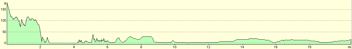
For more information on profiles, ascents and descents, see this page
Accommodation
We stayed at the White Water Caravan Club Site, which is a nice little site near the centre of Middlesbrough. The site cost us eight pounds for the night, and it was nice to stay at a campsite that it was actually pleasant to have a shower in, which is more than I could say for the last few sites that we have stayed at.
Disclaimer
Please note that I take no responsibility for anything that may happen when following these directions. If you intend to follow this route, then please use the relevant maps and check the route out before you go out. As always when walking, use common sense and you should be fine.
If you find any information on any of these routes that is inaccurate, or you wish to add anything, then please email me.
All images on this site are © of the author. Any reproduction, retransmissions, or republication of all or part of any document found on this site is expressly prohibited, unless the author has explicitly granted its prior written consent to so reproduce, retransmit, or republish the material. All other rights reserved.
Although this site includes links providing convenient direct access to other Internet sites, I do not endorse, approve, certify or make warranties or representations as to the accuracy of the information on these sites.
And finally, enjoy your walking!
This walk was mentioned in the following routes:
| My walk around the coastline of Britain |
Nearby walks
| # | Title | Walk length (miles) |
|---|---|---|
| 233 | Sunderland to Blackhall | 15.4 |
| 235 | Billingham to Redcar | 12.3 |
|
|

|