Walk #235: Billingham to Redcar
 |
 |
|
General Data
| Date Walked | 14/10/2002 |
| County | Cleveland |
| Start Location | Billingham |
| End Location | Redcar |
| Start time | 09.10 |
| End time | 14.36 |
| Distance | 12.3 miles |
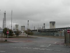
| Description | This was by far the least stimulating and most visually boring day of the trip so far. A large proportion of the day was spent sandwiched between a railway line and various chemical plants and steelworks whilst walking along the Teesdale Way; this has to rate as being one of the worst stretches of path that I have ever walked along. |
| Pack | Today I carried my 30-litre Karrimor HotRock rucksack, which was filled with my packed lunch, water bottle and a couple of spare shirts, together with the usual assortment of odds and ends. |
| Condition | I feel relatively fine after this short walk. The biggest problem that I had today was with my feet, which were aching as I had pout damp socks on this morning; a mistake I do not want to make again. Aside from this I was fine, with no problems to report. |
| Weather | The weather today started off with a light rain, which became heavier towards midday before slackening off and finally stopping. The day remained overcast, with no sign of any sun, but the dry period combined with the slight wind helped dry out my waterproofs. |
| OS map | Landranger number 93 (Middlesbrough, Darlington & Hartlepool) |
 |
 |
|
 |
 |
|
Map of the walk
Maps courtesy of Google Maps. Route for indicative purposes only, and may have been plotted after the walk. Please let me have comments on what you think of this new format. For a detailed table of timings for this walk, please see the table file.
Notes
I found today's walk to be fairly depressing as it consisted entirely of either road walking or walking through large industrialised areas. Even the Teesdale Way spent several miles sandwiched between two fences, with a railway line to the left and heavy industrial factories to the right. Considering this is a named path I expected a reasonable amount of signage and a good path underfoot; I was disappointed, however, and in places the path underfoot was boggy and in very bad repair. In these places it was trapped between two fences, so deviating off the path was not an option.
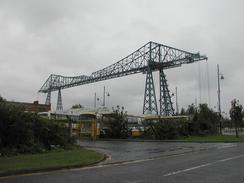
The highlight of the walk was the two bridges over the River Tees; firstly the Newport lift bridge, and secondly the Middlesbrough transporter bridge. Both of these are differing solutions to the same problem; how to let large ships sail down the river but allow road traffic to cross.
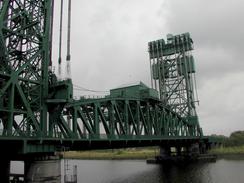
The Newport Lift Bridge was the first one that I came across. This was built in 1934 by the local firm of Dorman Long, who also built the Tyne Bridge, the transporter bridge further downstream and the Sydney Harbour Bridge. This bridge lifts by lowering two counterweights, which are suspended in the two towers at either end of the bridge.
The second bridge is the transporter bridge, which at 850 feet long is the largest working bridge of it's kind in the world. It is 225 feet high at its highest point, and can carry 200 people or six cars and one minibus across the river in just ninety seconds. The structure dominates the local area, and it must certainly be an impressive way of crossing the river. I can imagine the volume of traffic it can carry is quite low, however, so I cannot see many more of these being built in the future.
The River Tees used to meander much more than it does nowadays, so much so in fact that a vessel which was dependant on tides took as long to get from Stockton to Teesmouth as it did from Teesmouth to London. The 1810 Mandale Cut and the later Potrack Cut, which straightened the river and eased progress to the sea, alleviated this situation. The area immediately downstream of the Newport Bridge was filled with the Newport Ironworks, which was built in 1864 in an area known as the West Marsh, which is reclaimed land that is now twenty feet higher than it was 130 years ago. The ironworks have gone and have now been replaced by a park and some light industry, with only information boards to show how it used to be.
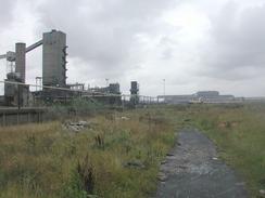
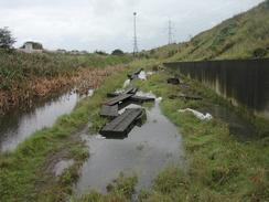
From the Newport Life Bridge I followed the Tessdale Way, a waymarked long-distance footpath that follows the Tees for about a hundred miles from high up in the Pennines to Redcar. Whilst this made navigation fairly easy, the path was hardly the best long-distance path that I have ever seen. Initially it is fairly good as it follows a bend in the river past the transporter bridge, a nightclub housed in a large ship and Middlesbrough football ground, but later on it gets sandwiched between a railway line and various steel and chemical plants. The footpath that the Teesdale Way follows on this stretch was originally developed to allow sailors to reach the sea, and is exceedingly aptly known as the 'Black Path'. It is by far the worst stretch of long-distance path that I have ever seen, and is one of the few walks that I have ever hated. The smells and noise from the plants was annoying, and towards the eastern end the path became very boggy. I ended up having to jump from one half-submerged timber to another, being careful not to get my boots wet with the foul-looking puddles.
As I walked along I started to look for somewhere to stop and have a bite of lunch. Early on in the walk it was raining so I did not really want to stop, and later on I did not really want to stop and eat in the industrial area once the rain had stopped. When I finally left the industrial area I decided to stop somewhere. At this stage I got slightly lost; I thought that the map showed that the path passed through the car park of the Corus plant beside a large brown building instead of alongside the road. I entered the car park and found a little cairn which I propped myself up against whist I ate. After eating I managed to get myself utterly disoriented whilst walking around the strangely shaped building and ended up on totally the wrong side of it from where I intended to be. A few minutes of walking got me back to where I meant to be, but not before I had walked right past the main entrance to the offices and had attracted some strange looks.
I am now thankfully out of the northeast conurbation, and I am faced with what should be far more scenic walking along the coastline of North Yorkshire, which should be far more entertaining. Unfortunately the weather forecast is for very bad weather over the next week (indeed, there are reports that the same sort of weather system that caused the great storm of 1987, exactly fifteen years ago, is now forming). I hope that this does not occur and the weather clears up, but I am afraid that that may be a vain hope.
Directions
This walk starts off in an industrial area beside the A1046 road, a little over a mile north of the junction with the A19; it is the place that I finished the previous walk. Follow the A1046 road south through a heavily industrialised area for about a mile south until you reach a roundabout junction with the A1032 road. Turn left and follow the A1032 road south-eastwards until it crosses the River Tees on the Newport lift bridge just upstream of the point where Billingham Creek and the River Tees meet.
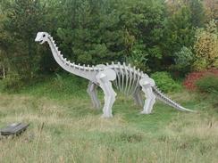
Cross the bridge on the downstream side and follow a little footbridge that leads off to the left onto the eastern bank of the Tees. This is part of the Teesdale Way, and initially heads north with the river to the left through an area where there used to be steelworks. The path sticks to the river as it turns to the right to head eastwards, where it heads inland over a grassy mound where dinosaurs lurk menacingly.
Follow a path from the dinosaurs to a road. Turn left along this road and follow it southeastwards, crossing over a roundabout until you reach the transporter bridge. Continue straight on past the bridge down a minor road. At a junction with a road to the right turn left and follow the road as it immediately turns to the right with some palisade fencing to the right. This road leads to a pedestrian footbridge that leads over a couple of dock gates and past a ship that appears to be being used as a nightclub before ending at a roundabout with a road beside the Middlesbrough football club stadium.
At the roundabout turn right and follow the road for a short distance as it turns to the left and ends at a roundabout. At the roundabout turn left and pass under a bridge below another road and head eastwards. After about a kilometre a roundabout with the B1513 is reached. Here the Teesdale Way follows the southern side of a railway line whilst the road continues on the northern side; however I could not find the place where the path joined the road. Rather then spend a long time looking for it, I decided to walk along the B1513 which paralleled the path until I could find a way over.
Follow the B1513 for about a kilometre until it reaches a roundabout. At the roundabout turn right and follow the road as it climbs to cross over the railway line, and immediately on the other side of the bridge turn left down the Teesdale Way, which initially runs along a tarmac path between two fences.
Continue following the Teesdale Way to the south side of the railway line for three or four miles, passing though a heavily industrialised area. At various places the path has oxygen and nitrogen pipelines running alongside it, or railway sidings, or buildings giving off fierce yellow glows as some hot process goes on within it. The Way passes South Bank Station, which seems a thoroughly depressing little station, and later on reaches a boggy area of ground with a very uneven and decrepit wooden walkway over it.
Eventually the Way turns to the right to head eastwards, with a fence to the right and yet another railway line beyond it. The path then rises up to the Lord McGowan Bridge, which carries the A1085 dual carriageway over the railway line. At the bridge turn left and cross the bridge to the eastern side. Follow the A1085 for about two kilometres until you reach a junction with a road that heads off to the left into Coatham, immediately to the west of Redcar. The Teesdale Way heads off to the left along this stretch of road to get into Coatham from a slightly different direction, but I could see no trace of this route on the ground. Turn left down this road and follow it over a bridge that crosses a railway line to a roundabout on the other side. At this roundabout continue straight on towards a car park at the seafront. The caravan park at which we stayed is immediately to the left at this car park, beside the entrance driveway to a golf course.
Distances
| From | To | Distance (m) | Ascent (ft) | Descent (ft) |
|---|---|---|---|---|
| Billingham | Middlesbrough football club | 4.9 | 49 | 62 |
| Middlesbrough football club | Redcar | 7.4 | 79 | 82 |
This makes a total distance of 12.3 miles, with 128 feet of ascent and 144 feet of descent.
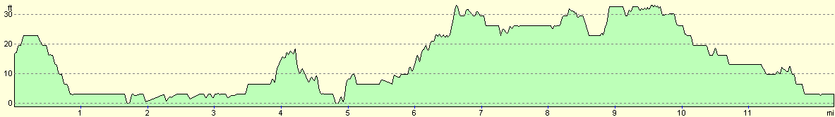
For more information on profiles, ascents and descents, see this page
Accommodation
We stayed at the Redcar Beach Holiday Park, which is next to the beach in Coatham, just to the west of Redcar. It cost us nine pounds for the night, and the facilities were good but basic. Annoyingly the toilets were clean but had no toilet paper, which is a nasty surprise if you are caught short.
Disclaimer
Please note that I take no responsibility for anything that may happen when following these directions. If you intend to follow this route, then please use the relevant maps and check the route out before you go out. As always when walking, use common sense and you should be fine.
If you find any information on any of these routes that is inaccurate, or you wish to add anything, then please email me.
All images on this site are © of the author. Any reproduction, retransmissions, or republication of all or part of any document found on this site is expressly prohibited, unless the author has explicitly granted its prior written consent to so reproduce, retransmit, or republish the material. All other rights reserved.
Although this site includes links providing convenient direct access to other Internet sites, I do not endorse, approve, certify or make warranties or representations as to the accuracy of the information on these sites.
And finally, enjoy your walking!
This walk was mentioned in the following routes:
| My walk around the coastline of Britain |
Nearby walks
| # | Title | Walk length (miles) |
|---|---|---|
| 234 | Blackhall to Billingham via Hartlepool | 20.5 |
| 236 | Redcar to Runswick Bay | 17.2 |
|
|

|