Walk #233: Sunderland to Blackhall
 |
 |
|
General Data
| Date Walked | 12/10/2002 |
| County | Tyne and Wear, Durham |
| Start Location | Sunderland Station |
| End Location | Blackhall |
| Start time | 10.57 |
| End time | 17.58 |
| Distance | 15.4 miles |
| Description | This was a long clifftop, beach and road walk south from Sunderland. |
| Pack | Today I carried my 30-litre Karrimor HotRock rucksack, which was filled with my packed lunch, waterproof coat, water bottle and a couple of spare shirts, together with the usual assortment of odds and ends. |
| Condition | The biggest problem I have had today is with some chaffing around my thighs, which did not really bother me until after I had finished the walk. Aside from this I had no real problems except for a slight fatigue. I have no blisters, and I could easily have walked further if I had needed to after a little rest. |
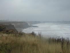
| Weather | The weather today was by far the worst of the trip so far. We woke up to the van being rocked from side to side by strong gusts of wind, which was allied with the sounds of sheets of rain hitting the van. For this reason I delayed the start, and although it rained fairly continuously I was lucky in that the wind died down to levels much below that of the last few days and for long periods the rain was only a light drizzle. I had many layers on and I never really got cold, except for my hand when my gloved got saturated. |
| OS map | Landranger number 88 (Newcastle Upon Tyne, Durham & Sunderland) and Landranger number 93 (Middlesbrough, Darlington & Hartlepool) |
 |
 |
|
 |
Map of the walk
Maps courtesy of Google Maps. Route for indicative purposes only, and may have been plotted after the walk. Please let me have comments on what you think of this new format. For a detailed table of timings for this walk, please see the table file.
Notes
I had a very late start to today's walk, as I had to get from the campsite that we stayed at in Whitley Bay back to Sunderland Station, where I finished yesterday's walk. This involved getting a bus from the park to Whitley Bay Station, a train to Newcastle and then another one out along the new line to Sunderland. The last of these links was delayed, and I amused myself by reading details of the affair between John Major and Edwina Currie, which was the headline in all the newspapers. I honestly thought that John Major would have had more taste! Ordinarily the delays and the weather (which was fairly awful) would have put me in a bad mood, but whilst I was waiting for what seemed like an interminably long period on a platform I started chatting to some fellow passengers, many of whom gave me unprompted donations to the charity! This was extremely kind, and I knew that I would be in a good mood whatever else happened today.
Once I finally reached the station in Sunderland the first task was to walk to the mouth of the Wear. This was easier said than done, although I retraced my steps back to the Wearmouth Bridge and then followed roads eastwards towards the sea. The main problem was that the Sunderland Docks got in the way; when I had viewed these from the north side of the river yesterday they had looked quite nice, with the cranes well painted and the area seemingly quite ordered. Today however, they were a pain in the neck as I had to make big diversions inland to reach Hendon and the sea. I put up with these diversions however, despite the fact that for some reason I found navigation difficult and the rain was lashing down onto me as I walked. Not many people were about this morning, probably due to the fact that it was a weekend, and I found myself walking along through the rain along the roads.
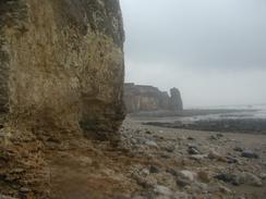
Eventually I found a way that I could reach the path that is marked as running along the bottom of the cliffs. This initially ran along the base of the cliffs along a little sea wall, but when this ended there was no way forward and I had to retrace my steps back for a hundred yards until I found a place that I could climb up to join the footpath that runs along the top of the cliffs. This was a bit of a climb, but once it was finished I had an easy stroll along the footpath past Salterfen Rocks and past the rocks called 'Pincushion' until I reached the B1287 road about a kilometre northwest of the village of Seaham. On the way I had a couple of gorges to cross, and at the second one of these (immediately after the Pincushion) I decided to walk along the foreshore below the cliffs instead of taking the clifftop footpath. This was a nice walk, although if the tide was high it would be an impassable route.
I have very mixed feelings about Seaham - for years King Coal ran the entire economy around here, and the closure of all the pits (Seaham alone had three) has left the area massively depressed. The local communities have been devastated by these closures, and once proud town such as Seaham are becoming derelict. Fortunately money is being spent on them, and Seaham now has new centres of employment opening, such as a business park. There are few signs of the old coalmines, and the last of them are now being landscaped with the pit gear and buildings being demolished, leaving only occasional 'heritage' items - the odd coal wagon in the town centre looking strangely out of place amongst the shops. And with them a piece of history is sadly going, and I wonder if people can get as much pride from working in a call centre as they did down from being down the pits. On the other hand, coal mining was very dangerous - in 1880 164 people and 181 pit ponies were killed in an explosion in one of the mines. A more modern disaster was the capsizing of the town's lifeboat in 1962; this led to the deaths of all five crew and four sailors picked up from a fishing boat.
On the southern side of Seaham I had difficulty finding my way back onto the clifftop footpath - the business park was still under construction and this had blocked off the most obvious route. In the end I found my way onto the path, and I started the long walk south along the cliffs to Chourdon Point. This area used to house yet another mine, although the area was fairly well landscaped and it was hard to imagine what it must have been like when the pit was still here. I can get an impression of it from John Merrill's book about his coastal walk in 1978 - he describes large conveyor belts dumping coal waste straight over the cliffs and into the sea, leaving a large black mound sticking up above the waves. Apparently at one stage there were seven of these conveyors, and I can only imagine what the Environment Agency would have to say about such practices today! Perhaps then the closure of the pits may a blessing in the long run, and the sea will have a chance to cleanse itself.
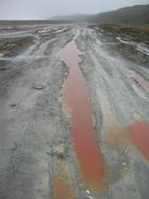
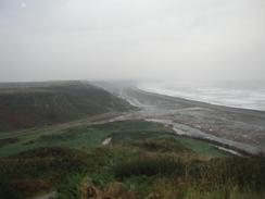
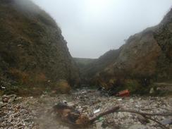
I walked along the cliffs until the path descends to the deep gorge at Dene Mouth, and I then decided to continue along the so-called beach. The state of the beach was absolutely unbelievable. I had read about polluted beaches in books about the walk, but nothing prepared me for this beach. Collieries to the north of this beach had tipped coal waste straight into the sea, and this had been washed by the sea southwards, where it accumulated on he beaches. I was walking along the beach and there were red puddles of water, and the whole scene had a smell that I had not smelt in years, since I spent summers working in a chemical plant. There was a heady chemical scent in the air, and the blackness of the ground (I could hardly call it sand) was depressing. I was amazed to find that the locals call this a beach, and that there were people actually fishing off it! Personally I would not touch anything that came out of the sea around this particular blighted stretch of coastline. Happily enough, however, the sea is slowly dispersing the pollution on this beach and eventually it may recover - but this will take many more years. At Castle Eden Denemouth there used to be salt flats where the sea invaded a flat area of land every so often, but the coal waste had formed a natural barrier to the sea and stopped the sea invading the land. Again, this is expected to occur once again when the beach has reduced in size now that the dumping of coal waste into the sea has stopped.
Until today the weather on this trip had been very good, with only one hour when I had needed to have my coat on due to rainfall. This good period had to end however, and it did so today, when there was heavy rainfall to contend with. Fortunately it had proved that all of my waterproof kit works quite well, and both my base layer top and bottoms were both dry when I had peeled off the top layers. The only place I had trouble was with my gloves, which despite being the thick ones still got saturated eventually, probably because I was holding my walking poles.
Directions
This walk starts off at Sunderland Station. Leave the station and walk north along a road through the centre of the city until you reach a roundabout; here turn right to walk eastwards for about half a kilometre until it reaches another roundabout. At this roundabout turn to the left and join the B1293 as it parallels the river. When the B1293 ends remain on the road as it curves to the right for a few hundred metres and then once more to the right to head southwestwards. Remain on this road as it curves around on a general southerly heading until it reaches the B1294 road. Here turn right, and follow the B1294 westwards until another roundabout is reached. At this roundabout turn left and join the B1522, which heads southwards for about four hundred metres to another roundabout; continue straight over this one to continue south along the B1522. About a kilometre from the roundabout turn left and take a road that leads off eastwards towards the sea, passing under the railway line before ending at a car park.
At the car park I descended down the cliffs to the seawall at the base of the cliffs and walked south along this; alternatively it may be better to walk along the top of the cliffs, as fairly soon I had to climb back up the cliffs when the seawall ended. About a kilometre north of Salterfen Rocks a proper footpath begins, and this can be followed south all the way past Pincushion and on towards Seaham. North of Pincushion, however, I descended onto the beach and walked south along that, although this would not be possible at high tide. When the footpath meets the B1287 road head southeastwards along the road as it enters Seaham. When the main road bends sharply to the right continue straight on down another road to a roundabout. The rest of my route south from Seaham was not very good as building works obstructed me, so make your way to the footpath that runs along the top of the cliffs towards Nose's Point, and then on to Chourdon Point.
For the next mile the footpath is sometimes squeezed between the railway line and the cliff edge, and a descent down into Hawthorn Hive, with a lovely railway viaduct a short distance inland, ensues. The path climbs up the south side of the Hive and follows the eastern side of the railway line for about a kilometre before rejoining the clifftop near Shot Rock and following the edge south to another valley. The path turns to head inland through woodland on the north side of a stream, but I managed to cross it and climb up the other side to gain the cliffs and walk south past Horden Point for a kilometre until another valley stopped me. Here I joined the beach, and followed it as it slowly curves away to the southeast for well over a mile until I reached Dene Mouth, the mouth of the Castle Eden Dene. Here I climbed back up onto the top of the cliffs, and followed the edge of the cliffs southeastwards until another steep valley called Blue House Gully stopped me. Here I headed inland towards the railway line, and I then turned left to follow the line southeastwards until I hit a road, where I turned to the right to cross under the railway line and continued up to the A1086 road, where Sam was waiting for me.
Distances
| From | To | Distance (m) | Ascent (ft) | Descent (ft) |
|---|---|---|---|---|
| Sunderland Station | Seaham | 7.0 | 554 | 587 |
| Seaham | Blackhall | 8.4 | 1020 | 912 |
This makes a total distance of 15.4 miles, with 1574 feet of ascent and 1499 feet of descent.
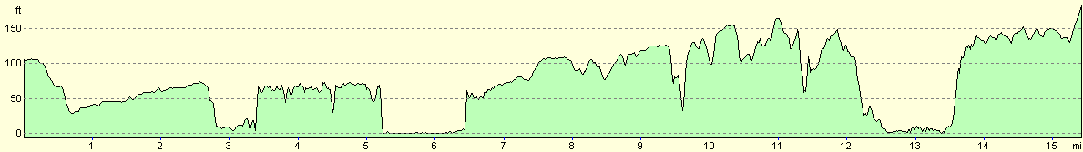
For more information on profiles, ascents and descents, see this page
Accommodation
We stayed at the Ash Vale Park, in Easington Road, Hartlepool, TS24 9RF, telephone 01429 862111. I really did not get much of a chance to look around this site, but the tourers section was right at the back of the site beyond a plot of land where caravans were being stored, and hence it was not the nicest part of the site.
Disclaimer
Please note that I take no responsibility for anything that may happen when following these directions. If you intend to follow this route, then please use the relevant maps and check the route out before you go out. As always when walking, use common sense and you should be fine.
If you find any information on any of these routes that is inaccurate, or you wish to add anything, then please email me.
All images on this site are © of the author. Any reproduction, retransmissions, or republication of all or part of any document found on this site is expressly prohibited, unless the author has explicitly granted its prior written consent to so reproduce, retransmit, or republish the material. All other rights reserved.
Although this site includes links providing convenient direct access to other Internet sites, I do not endorse, approve, certify or make warranties or representations as to the accuracy of the information on these sites.
And finally, enjoy your walking!
This walk was mentioned in the following routes:
| My walk around the coastline of Britain |
Nearby walks
| # | Title | Walk length (miles) |
|---|---|---|
| 232 | Howdon Station to Sunderland Station | 15.3 |
|
|

|