Walk #836: Newbury to Reading
 |
 |
|
General Data
| Date Walked | 17/03/2009 |
| County | Berkshire |
| Start Location | Newbury business park |
| End Location | Reading station |
| Start time | 09.32 |
| End time | 16.23 |
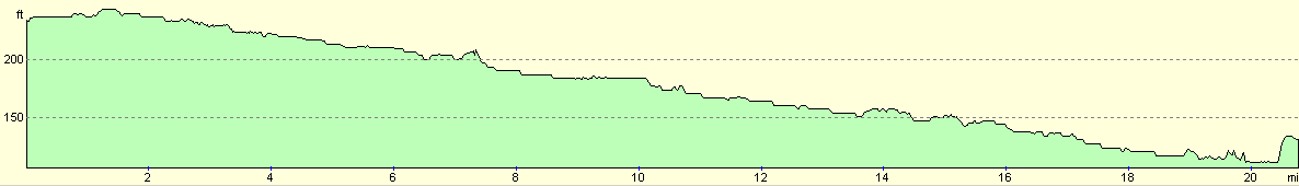
| Distance | 20.8 miles |
| Description | This was a highly pleasant walk, following the Kennet and Avon Canal eastwards towards its terminus with the Thames. |
| Pack | Today I carried a very light pack, without the breast pockets. |
| Condition | I feel fine after this walk. I have a few hotspots on my toes, but am otherwise okay. |
| Weather | Today was a lovely sunny day, with only occasional hazy clouds to spoil the sunshine. There was a bit of a cooling breeze, but I still managed to get of sunburn on my face. |
| OS map | Landranger number 174 (Newbury & Wantage, Hungerford & Didcot) and Landranger number 175 (Reading & Windsor, Henley-on-Thames & Bracknell) |
 |
 |
|
 |
 |
|
Map of the walk
Maps courtesy of Google Maps. Route for indicative purposes only, and may have been plotted after the walk. Please let me have comments on what you think of this new format. For a detailed table of timings for this walk, please see the table file.
 |
 |
|
 |
 |
|
Notes
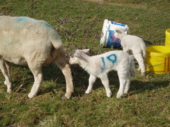
Sencan had a business meeting in Newbury today, and as she is not quite happy with driving long distances, I agreed to drive her once again. We pulled up in the car park of the business on Newbury Business Park, on the eastern side of the town, and got some curious looks from men in suits as I got all my walking garb together. Eventually debecked with rucksack and warm clothes, I strode off.
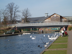
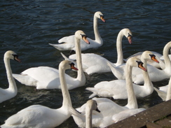
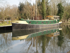
My initial aim was to reach the centre of the town, where Sencan and I had started a walk along the Kennet and Avon canal earlier in the year. This proved to be easier said than done, and involved walking along grime-gilled roads that ran through the centre of the town. Things improved when I reached the canal; instantly the walk became far nicer as I headed right into the centre of the town. People were feeding what looked like hundreds of swans, and the entire atmosphere was relaxed. Frankly, I could have taken my rucksack off and sat on a bench all day.
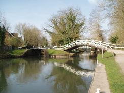
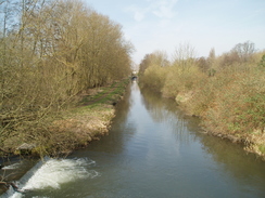
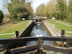
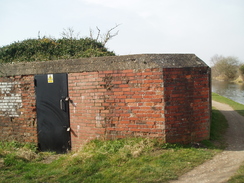
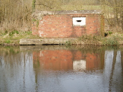
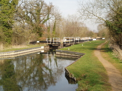
Instead, I reached the bridge in the centre of town and immediately turned around to head once more out of the town. I soon passed the point that I had joined the towpath, and was in relatively virgin territory. I had walked this stretch of canal in 2000, and yet I could remember very little about that walk aside from a nasty insect bite I received near Greenham Lock. The stroll was very pleasant as I passed a series of locks; the towpath swapped from one side of the canal to the other. A series of pillboxes became visible; , all part of the GHQ stop-line Blue, which was built to protect this stretch of the Kennet & Avon Canal from a potential German invasion. Some were made from brick, whilst others had a brick lining around them - was this to appease locals, or to make them harder to sport from the air?
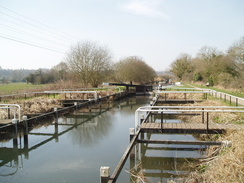
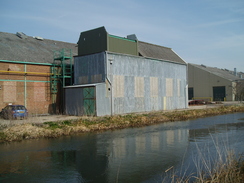
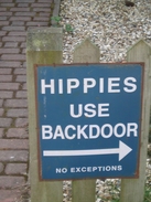
Monkey Marsh lock was unusual in that it had turf sides, not brick walls; apparently many of the canal's lock had been built in such a manner, although the wastage of water meant that many were rebuilt with more conventional brick walls. In Thatcham another traditional sight - canalside industrial buildings - reared their heads, the sheet metal glinting off the water's surface. The rarity of these interlopers almost made them things of beauty, a connection with the reason that the canal had been built in the first place. At Colthrop Lock there was an amusing sign - 'Hippies use backdoor - no exceptions', with an arrow pointing ointo a house. Quite what that was about is anyone's guess. On the other side of the canal a new pit was being built; sand or gravel, I guessed. A workmanlike bridge had been constructed across a stream into anther field that had been freshly pegged out for an extension.
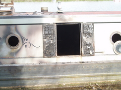
Between Cowthorp and Misgham Locks was a sorry-looking burnt out narrow boar, the bows badly burnt but the stern relatively intact. Singed wood was visible through the openings. Being metal the boat had not sunk, but I wondered if it would ever be able to be restored.
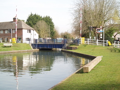
The canal took me on through Woolhampton, where some maintenance work was being performed on the canal, and then along a pleasnt tree-lined stretch of towpath to Aldermaston Lock. I stopped here to take my fleece off, before crossing the swing bridge that carried the A340 over the road. Just off the towpath on the other side was a little canalside shop and museum, which I entered to buy a few provisions for the rest of the day. This had only just opened for the season, and was a welcome find. I was tempted to have a look around, but time was pressing.
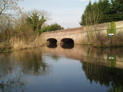
More locks were passed as the canal continued winding its way eastwards. At Ufton bridge I made a mistake; at the bridge toe towpath crosses over to the southern side of the canal, but I continued on along the northern bank, following a good fisherman's path. Soon the path became narrower and I soon passed a sign marked private. As the path was good I continued on, noting my mistake on the map. The path soon deteriorated as it was squeezed between Tyle Mill on the right and the railway line on the left. Eventually it ended. To the right was a fence guarding the gardens of an expensive-looking house. I crossed the plank and scrambled up a steep bank to reached the road by the bridge over the railway line. I crossed this and then descended to meet the canal at Tylemill Bridge.
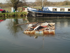
On the other side of the canal by the lock was a pillbox that had been converted to another use. More pleasant walking followed, passing a series of locks and passing under the M4. On Burghfield Lock there was a scrawled, handwritten notice: 'Canal closed due to sunken boat'. I was unsure how much credence to put on this, and I continued on. After passing under Burghfield Bridge I saw a group of people waiting on the towpath, and the top of something sticking out of the water. This soon resolved itself into the top of a boat, strewn with various odds ands sods. This was nearly at right-angles across the canal, and the owner could not have done a better job if he had tried to block the canal on purpose. Apparently the boat had been there for a couple of days, and many boars were moored up waiting to pass.
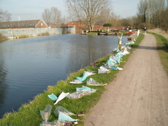
A little further on I came across a boar moored at the side of the canal that was from Stenson, the lock and marina on the Trent and Mersey Canal in Derbyshire at the side of which I was born. The sight brought back many memories. At Fobney Lock a less pleasant sight came into view; a long series of decaying bunches of flowers stretched along the side of the towpath. It was only when I saw a crimson tie tied around a bollard that I remember a story that had played heavily on the news. In late January, the body of Jonathan Marques, a 15-year old local schoolboy, was found in the lock. I muttered a quick prayer as I passed, suddenly feeling a little bit lower.
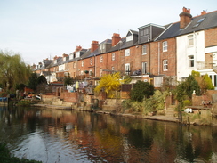
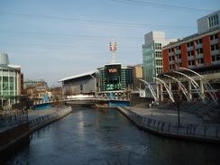
From here on the going became slightly more urban. The canal passed under a modern bridge and then turned to head northwards towards the Thames in Reading. The path underfoot became firmer, and soon some terraced housing became visible on the other side of the river. Suddenly I was dumped out into a thoroughly modern commercial development; The Oracle shopping center. Here shops, pubs and entertainment venues all based around the canal, including a large Vue cinema. All of a sudden I felt utterly out of place amongst the trendily-dressed people. An hour before I had been in the countryside, and now I was in a modern urban environment. Frankly, I felt misplaced.
I left the canal here and headed through town towards the station. The route was not clear, and a kind man walked alongside me as he showed me the way. We parted near the Town Hall, and I soon found myself at the station. I purchased a ticket and went to wait on the platform. Sencan phoned and told me that she would meet me at Newbury station, and I gobbled down some Marks and Spencers' fruit - refreshing after a surprisingly warm spring day. Ticket inspectors were on the train on the way back, and one of these had trouble with a man standing beside me in he vestibule. The train pulled up at a station and the man jumped out onto the platform; he had said that he wanted to get back to Newbury, so he had left himself with a fair walk.
All in all this was a very pleasurable day's walk along the canal.
The Kennet and Avon Canal
The Kennet and Avon Canal runs for 87 miles from Bath on the River Avon in the west, to Reading on the Thames in the east. At first the rivers were canalised, and finally the remaining stretch between Newbury and Bath came into use in 1810, after a survey by the famous engineer John Rennie. Sadly, the coming of the Great Western Railway in 1841 (which parallels the canal for much of the way) led to the canal losing much of its traffic.It fell into neglect, but a long restoration campaign led to it being reopened in full in 1996.
There are many locations of interest on the canal; perhaps the most famous is the spectacular flight of 20 locks atCaen Hill, immediately to the west of Devizes. Another feature is the Doric-styled Dundas Aqueduct, to the east of Bath. There is only one tunnel on teh entire route; the 502-yard Bruce Tunnel.
I first walked the majority of the canal in 2000, as part of my sectional Land's End to John O'Groats walk. Since then I have always had a soft spot for the canal, although I have only got to walk it again since I moved down to Southampton.
 |
 |
|
 |
 |
|
Directions
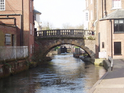
This walk starts off at Newbury business park. If you wish to start from Newbury railway station, follow the directions in the next paragraph. Leave the business park and turn right to start heading westwards along the A4 for about two-thirds of a mile. When a large roundabout is reached turn left along another dual carriageway for about a third of a mile until the Kennet and Avon canal is reached. Descend to join the canal towpath, and then turn right to follow it westwards towards the centre of the town. When an ornate bridge over the canal is reached in the centre of the town, turn around and head back in the same direction.
Alternatively, start from the car park on the northern side of Newbury railway station, opposite the main entrance. Walk half-left through the car park, aiming for some steps that lead up to a road. This heads past a building before ending at another road opposite a car park. Turn left along this road, and then right to start heading along a street lined with shops. Continue on until an ornate bridge over the Kennet and Avon canal is reached.
Join the canal and start following it eastwards. Follow the canal for about nineteen miles. The towpath stays by the canal at all times, although it frequently swaps from one side to the other and care needs to be taken to be on the correct side (there is frequent signage to help). I left the canal in the centre of Reading, and headed along local roads northwards towards the main railway station in the town. I could not see signposts, but people seemed to be helpful enough in helping me find it.
 |
 |
|
 |
 |
|
Distances
| From | To | Distance (m) | Ascent (ft) | Descent (ft) |
|---|---|---|---|---|
| Newbury business park | Newbury | 1.4 | 16 | 7 |
| Newbury | Aldermaston Wharf | 9.0 | 72 | 141 |
| Aldermaston Wharf | Reading station | 10.4 | 112 | 154 |
This makes a total distance of 20.8 miles, with 200 feet of ascent and 302 feet of descent.
For more information on profiles, ascents and descents, see this page
Transport
There are regular train services between Reading and Newbury.
 |
 |
|
 |
 |
|
 |
Disclaimer
Please note that I take no responsibility for anything that may happen when following these directions. If you intend to follow this route, then please use the relevant maps and check the route out before you go out. As always when walking, use common sense and you should be fine.
If you find any information on any of these routes that is inaccurate, or you wish to add anything, then please email me.
All images on this site are © of the author. Any reproduction, retransmissions, or republication of all or part of any document found on this site is expressly prohibited, unless the author has explicitly granted its prior written consent to so reproduce, retransmit, or republish the material. All other rights reserved.
Although this site includes links providing convenient direct access to other Internet sites, I do not endorse, approve, certify or make warranties or representations as to the accuracy of the information on these sites.
And finally, enjoy your walking!
Nearby walks
| # | Title | Walk length (miles) |
|---|---|---|
| 61 | Reading to Marlow | 18.5 |
| 74 | Wooton Rivers to Kintbury | 16.4 |
| 75 | Kintbury to Newbury | 9.3 |
|
|

|