Walk #75: Kintbury to Newbury
General Data
| Date Walked | 04/04/2000 |
| County | Berkshire |
| Start Location | Holt Lodge (Kintbury) |
| End Location | Newbury station |
| Start time | 09.25 |
| End time | 12.35 |
| Distance | 9.3 miles |
| Description | A few hours of road walking to the north-east of Newbury. |
| Pack | Today I carried full Pennine Way kit. |
| Condition | I feel okay after this walk, although my feet are a bit tired. |
| Weather | There was snow, sleet and rain today, with no sunshine. Thsi was accompanied with a very cold and bitter north-easterly wind. Started off with snow on the ground this morning. |
| OS map | Landranger number 174 (Newbury & Wantage, Hungerford & Didcot) |
Map of the walk
Maps courtesy of Google Maps. Route for indicative purposes only, and may have been plotted after the walk. Please let me have comments on what you think of this new format. For a detailed table of timings for this walk, please see the table file.
Notes
I woke up this morning to find fresh snow on the ground, an unusual sight for Berkshire in April. I had an early breakfast and sat chatting to the proprietor of the B&B for 45 minutes before heading off.
It was snowing when I first emerged from the B&B, and although this soon stopped for a period, it was either raining, sleeting or snowing for the rest of the time that I was walking. To make matters worse, all this came with a bitterly cold northeasterly wind. Although all my clothes were fully dry to the nice people in the B&B, it was pretty miserable weather. Due to the heavy rain, I did not fancy walking along the canal that was bound to be muddy, so I decided to road-walk all the way into Thatcham on the other side of Newbury.
By the time I got past Newbury and onto the road on the south side of Greenham Common, I was a bit annoyed and fed up. I saw a sign informing me that it was another 6 miles along the winding road to Thatcham, and so I decided to call it a day and walk the 1.5 miles into Newbury to catch a train for the three and a half hour journey back to Cambridge.
This means that I did not get as far as I wanted to during the four days of walking (I was 6 miles short of my original target of Woolhampton), but over the four days I did manage to get the 60 miles total distance done. The extra 6 miles were done on diversions due to stoppages on the canal and today when I road walked instead of following the canal.
All in all I am very pleased with the way that this particular walk has gone - I walked much farther on the first day than I expected, and I managed to keep up the distance on the third day despite awful weather. I have noted some deficiencies in my kit, which I shall fix before I set off to do the Land's End to Minehead legs in less than two weeks time.
Directions
Head up the drive from Holt Lodge until you meet the road. Turn right at the road and then take the next right down Forbury Lane, which takes you past Forbury House. At the end of this road, turn right and then immediately left to take the road that leads through the village of Hamstead Marshall. Continue along this road as it goes through Crockham Heath and then leads on to pass under the controversial A34(T) Newbury bypass.
Head up the hill and into the outskirts of Newbury. At the top of the hill turn left past Common Farm and then follow the road as it swings around to the right. Follow this road past the Falklands Memorial near the A343. Cross the A343 and follow the road up to a roundabout on the A339(T). Carefully cross the dual carriageway and head east along the road into Greenham.
In Greenham take the second left just past the start of Greenham Common. Head down the hill, passing the church on the right. Keep on the road as it becomes a track (it has been closed to traffic) to the bottom of the hill where it becomes a road again in a housing estate. Follow the road through the estate past one edge of Newbury race course. From here head south to cross the railway line and join the B3421 road. Turn left and follow this westwards; when a roundabout is reached turn left to reach the approach road to the railway station. Turn right, and walk up to Newbury station. Note that Newbury racecourse station is nearer, but has far fewer services then the main station.
Distances
| From | To | Distance (m) | Ascent (ft) | Descent (ft) |
|---|---|---|---|---|
| Holt Lodge | A343 | 5.9 | 282 | 328 |
| A343 | Newbury station | 3.4 | 49 | 200 |
This makes a total distance of 9.3 miles, with 301 feet of ascent and 528 feet of descent.
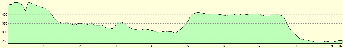
For more information on profiles, ascents and descents, see this page
Disclaimer
Please note that I take no responsibility for anything that may happen when following these directions. If you intend to follow this route, then please use the relevant maps and check the route out before you go out. As always when walking, use common sense and you should be fine.
If you find any information on any of these routes that is inaccurate, or you wish to add anything, then please email me.
All images on this site are © of the author. Any reproduction, retransmissions, or republication of all or part of any document found on this site is expressly prohibited, unless the author has explicitly granted its prior written consent to so reproduce, retransmit, or republish the material. All other rights reserved.
Although this site includes links providing convenient direct access to other Internet sites, I do not endorse, approve, certify or make warranties or representations as to the accuracy of the information on these sites.
And finally, enjoy your walking!
This walk was mentioned in the following routes:
| My sectional Land's End to John O'Groats walk |
Nearby walks
| # | Title | Walk length (miles) |
|---|---|---|
| 74 | Wooton Rivers to Kintbury | 16.4 |
| 99 | Newbury to Reading | 19.6 |
| 100 | A circular walk including Inkpen, Walbury Hill and Pilot Hill | 10.4 |
|
|

|