Walk #76: Bingham to Nottingham
 |
 |
|
General Data
| Date Walked | 08/04/2000 |
| County | Nottinghamshire |
| Start Location | Bingham |
| End Location | Nottingham |
| Start time | 09.45 |
| End time | 15.55 |
| Distance | 13.5 miles |
| Description | This was a pleasant walk through Nottinghamshire, followed by road walking into the city centre. |
| Pack | Today I carried full Pennine Way kit. |
| Condition | I feel fine after this walk. |
| Weather | There was nice, warm sunshine today with some hazy cloud. A bit of a cool breeze made this ideal walking weather. |
| OS map | Landranger number 129 (Nottingham & Loughborough, Melton Mowbray) and Nottingham A to Z |
Map of the walk
Maps courtesy of Google Maps. Route for indicative purposes only, and may have been plotted after the walk. Please let me have comments on what you think of this new format. For a detailed table of timings for this walk, please see the table file.
 |
Notes
I had not intended to do a walk this weekend, as I wanted to give myself a short break before setting off on the 250 miles Land's End to John O'Groats sections. However, due to a rather nice weather forecast, and the news that Sarah (an old friend of mine who lives in Gedling on the route) was available, I decided to do it earlier than expected.
The walk was split into two distinct parts; the walk from Bingham to Gedling, where I had lunch with Sarah, and the road walk afterwards from Gedling into the centre of Nottingham. Perhaps the reason that I felt so fit at the end of the walk was the fact that I took such a long (for me) break at lunch - I was in a similar situation last Saturday when I had an hour-long break in Semington, and then walked another 6-7 miles into Devizes. Perhaps I should learn to take more breaks in my walks...
The first part of the walk went quite quickly, although I did get slightly lost for five minutes when climbing out of Burton Joyce towards Lodge Farm. Some kind horse riders put me right, though.
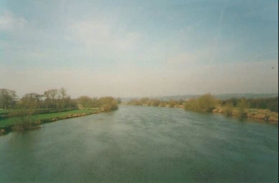
All in all this was a highly enjoyable day. In particular the walk beside the Trent through Burton Meadows was highly enjoyable.
Directions
From Bingham market place head north out of the town via Moor Lane which leads to an occupation crossing that is immediately to the west of Bingham station platforms. This crossing leads to a path that skirts some playing fields before crossing Moorbridge Road East and following the eastern side of a drain heading northwards. This path brings you out just to the east of a roundabout joining the A46(T) and the A6097. Carefully cross the A46(T) and head past Burrow Fields Farm across fields to the village of East Bridgford.
In East Bridgford head up Walnut Tree Lane, and at the end turn left down the main road through the village. At a junction head downhill down Cuttle Hill and follow the road as it bends to the west alongside the River Trent. Shortly you reach the A6097 and can cross the Trent via Gunthorpe Bridge.
Do not cross the road on Gunthorpe bridge, but keep to the easterly side and once on the northern bank, turn down a road to the east leading into the village of Gunthorpe. Shortly later at the bottom of the descent there is a marina. Enter the marina's car park and find a path that leads west under Gunthorpe bridge. This little diversion saves having to cross the A6097. Follow the path along the River Trent for one kilometre before you meet a little track called Trent lane. You can now either take a short cut directly across Burton Meadows via Trent Lane or continue along the good path beside the Trent.
If you follow the bank of the River Trent you will eventually meet up with Trent Lane once more. Follow it over the Nottingham to Grantham railway line and enter the village of Burton Joyce. In Burton Joyce, cross over the A612 main road and enter the village via Meadow Lane. Turn left at a church and follow Main Street through the village. Shortly before the road swings left to rejoin the A612, turn right up Lambley Lane. Climb up the hillside towards Lodge and Stockhill Farms at the top of the hill. Just past Lodge Farm, take a bridleway called Grass Road that heads west, bypassing the village of Lambley, to Wood Farm.
At Wood Farm do not join the road but take a footpath to the left just past the farm that heads south downhill past Gedling Wood into the village of Gedling. On the first part of this walk as you pass the site of the old Gedling colliery you get beautiful views to the south and east over the Trent valley. At the bottom of the hill the footpath meets Almond Walk in Gedling. Turn left and almost immediately take another left along Yew Tree Lane as it ascends a steep hill. At the top turn right and head down Wood Lane. At the bottom of this hill you pass under a railway bridge and you meet the A6211 road.
You are now on the outskirts of the Nottingham conurbation. It is easy to plan your own route through to the city centre, but below I shall detail the route that I took.
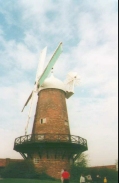
Turn right along the A6211 and take the first left down Waverley Avenue. At the end turn right and then immediately left down Vernon Avenue. At the end of Vernon Avenue turn right along Blackhill Drive until you meet Gedling Main Road. Turn left down Gedling Main Road and follow it until it ends where it meets the B686. Turn right down the B686 and follow it past a superstore on the right. Shortly after the store turn left and ascend Southdale Road. Continue along this road as it becomes Parkdale Road and then Oakdale Road. When a roundabout is reached turn left down Sneinton Dale Road. This road continues southwestwards for over a mile before it passes Greens Windmill on the right. Shortly after the windmill it turns northwards to rejoin the B686.
Turn left down the B686 and cross the A60. From here it is a simple job of walking through the city centre to the bus station; a suggested route is to head westwards through the Lace Market area of Nottingham via Barker Gate, Broadway and Pilcher Gate. Turn left down Middle Hill to reach the bus station in the Broadmarsh centre.
Distances
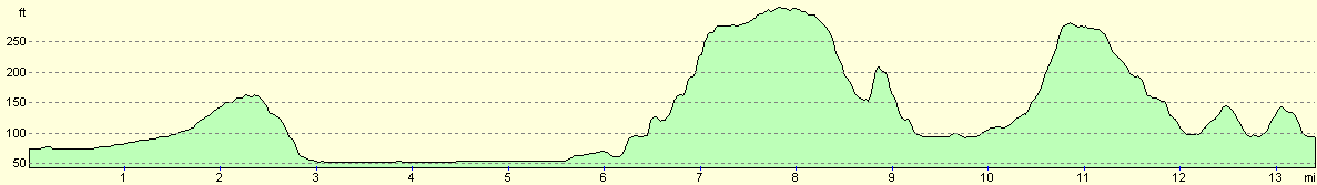
| From | To | Distance (m) | Ascent (ft) | Descent (ft) |
|---|---|---|---|---|
| Bingham | Gunthorpe | 3.4 | 98 | 121 |
| Gunthorpe | Gedling | 6.0 | 354 | 312 |
| Gedling | Broadmarsh bus station | 4.1 | 295 | 299 |
This makes a total distance of 13.5 miles, with 747 feet of ascent and 732 feet of descent.
For more information on profiles, ascents and descents, see this page
Transport
Bingham has a railway station on the Nottingham to Grantham line so it is possible to catch a train back to the walks starting point.
Alternatively, there are regular bus services (every fifteen minutes) from the Broadmarsh bus station in Nottingham to Bingham Market Square. Gedling and Burton Joyce also have very good bus links with the city centre.
Disclaimer
Please note that I take no responsibility for anything that may happen when following these directions. If you intend to follow this route, then please use the relevant maps and check the route out before you go out. As always when walking, use common sense and you should be fine.
If you find any information on any of these routes that is inaccurate, or you wish to add anything, then please email me.
All images on this site are © of the author. Any reproduction, retransmissions, or republication of all or part of any document found on this site is expressly prohibited, unless the author has explicitly granted its prior written consent to so reproduce, retransmit, or republish the material. All other rights reserved.
Although this site includes links providing convenient direct access to other Internet sites, I do not endorse, approve, certify or make warranties or representations as to the accuracy of the information on these sites.
And finally, enjoy your walking!
This walk was mentioned in the following routes:
| My sectional Land's End to John O'Groats walk |
Nearby walks
| # | Title | Walk length (miles) |
|---|---|---|
| 60 | Slough to Alperton | 16.7 |
| 61 | Reading to Marlow | 18.5 |
| 139 | West Drayton to Kings Langley | 16.6 |
|
|

|