Walk #871: West Bexington to Charmouth
 |
 |
|
General Data
| Date Walked | 30/10/2010 |
| County | Dorset |
| Start Location | West Bexington |
| End Location | Charmouth |
| Start time | 09.05 |
| End time | 15.51 |
| Distance | 13.5 miles |
| Description | This was a strenuous yet ultimately rewarding walk along this strenuous stretch of the South West Coast Path. |
| Pack | Today I carried my 30-litre Karrimor rucksack, filled with water, my waterproofs, a couple of books and other odds and ends. |
| Condition | I was fairly ill during, and after this stroll. This is more to do with my underlying physical condition that the walk itself. |
| Weather | Today's weather was a mixture of sunshine and cloud. Initially it was fairly cold, but the day soon warmed during the sunny periods. |
| OS map | Landranger number 194 (Dorchester & Weymouth, Cerne Abbas & Bere Regis) and Landranger number 193 (Taunton & Lyme Regis, Chard & Bridport) |
 |
 |
|
Map of the walk
Maps courtesy of Google Maps. Route for indicative purposes only, and may have been plotted after the walk. Please let me have comments on what you think of this new format. For a detailed table of timings for this walk, please see the table file.
 |
 |
|
Notes
Sencan and I felt like doing another stroll along the South West Coast Path today, as the weather looked good, we set off early for West Bexington. The car park was virtually empty when we got there, aside from a van belonging to the man cleaning the toilet, and another to a fisherman who was out and about unfeasibly early. Last time we were here the car park ticket machine had been out of order, but today, unfortunately, we had to pay our five pounds for the stay.
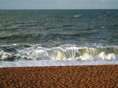
We were unsure what our plans were for the day; we had an option to reach as far as Lyme Regis, but that would be a very strenuous day. An alternative - to walk as far as West Bay before returning by the same route, which would have been a very short day. The first few miles were along the westernmost end of Chesil Beach, but the path underfoot was very good. Soon we came across a foot-long fish lying on the shingle, dead and part-rotted. This had obviously fallen off a fisherman's trolley, and made for a slightly sad sight.
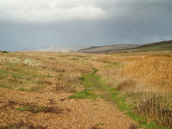
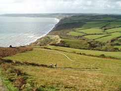
Soon the path headed inland slightly, with a hedge separating the path from the beach. It was a green walk, with the hillside sloping up to the right. It was obviously a well-walked path, with lots of little tributary paths leaving and joining it, to the extent it was hard at times to know which was the 'proper' path behind Burton Mere. The first climb of the day occurred right after the mere, a short and untroublesome climb up onto cliffs; a welcome relief after the last few level miles.
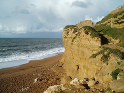
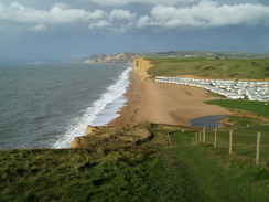
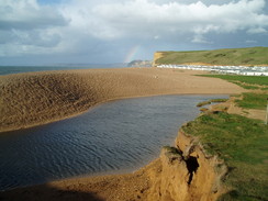
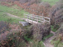
The cliffs soon descended down to Burton Beach. There was a cafe here, and Sencan nipped in to get some provisions. I was starting to feel slightly unwell, so I hung about outside, where it was cooler. We soon set off once again, with Sencan munching on a large chunk of apple cake. Burton cliffs seemed to shine in the sunshine, and the next climb was easy, but was followed by a couple of steep descents and ascents into and out of dry valleys. A final descent took us towards the placid Burton Freshwater, whose outfall is neatly blocked by the shingle beach. Unfortunately there is no bridge over the mouth of the river, and a short, unnecessary diversion is needed upstream to a footbridge. A caravan park dominates the other side of the river, but this was very quiet at the time of year.
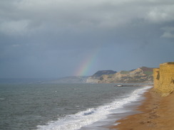
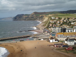
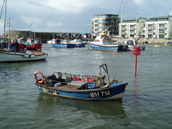
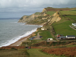
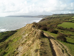
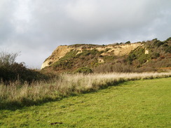
Another climb led us up onto the East Cliffs, where a distant rainbow could be seen over the sea. This stretch of path rose and fell, but the views more than made up for the exertion. Eventually it fell once more, joining the shingle beach by some yellow diggers at the eastern end of West Bay. This is well known as being a quiet seaside village, dominated by the town of Bridport inland. I have read comments saying that recent developments have spoiled it, but I could not say that was the case - it is still an attractive place, with lots of wooden cabins selling various food and fish. A crane was lifting boats out of the harbour, placing them on what appeared to be a car park. For some reason I really enjoyed the village, even though we did not stop. Our plan had been to turn back at West Bay, but we both felt fit enough to push ourselves further.
At the top of the next hill I told Sencan that the climb had been easy; this statement had obviously upset the Gods, as I was immediately sick. I continued walking on, retching occasionally. I was starting to feel rather awful, but Sencan was still on good form. The path descended to Eype Mouth, where I noticed that my legs were starting to shake. With hindsight we should have stopped here and walked out to the main road to get the bus, but instead we continued on. Another climb took us up to Thorncombe Beacon, and an enjoyable stroll led us over various hills and cliffs before the descent down to Seatown.
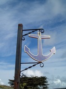
The Anchor Inn nestles prettily under the cliffs, and we decided to stop off here for a quick bite to eat. We ordered a basked of chips each, and I felt better once the food was in my system. Sencan was looking up at the next hill - Golden Cap - with a certain amount of trepidation. I have an advantage over her, as I have done so much walking that I am well aware of what I am capable of. For her, however, such hills seem worryingly steep. Experience has its benefits.
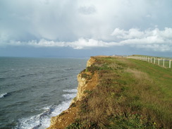
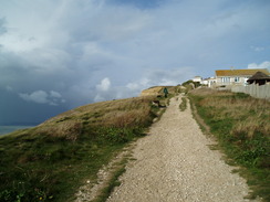
We left the pub and started the climb up to Golden Cap. Sencan was slightly nervous about this, but I was looking forward to reaching the highest point on the entire south coast. The footpath follows another diversion due to landslips, but this has obviously been in place for some time. Initially the climb is nice and easy, but as you get higher increasingly steep steps take over, with ropes to help you up. I was feeling surprisingly tired, and my left thigh was starting to ache. We stopped several times before we reached the top.
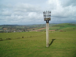
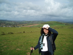
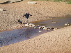
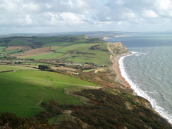
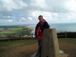
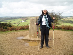
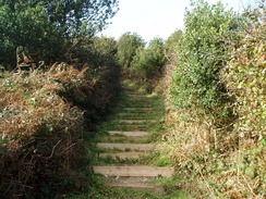
The views from the top were superb, and we took photos of each other against the trig pillar. It had been snowing the last time I had been up here, and it was good to see the hills in nicer - if not much warmer - weather. Sencan seemed really happy to have made it to the top, and we fooled around for a while before starting off down the western side. This starts of fairly steeply, and the path zigzags down the hillside. What followed was a couple of surprisingly energy-sapping miles as the path rose and fell, crossing a couple of streams as it went. By this stage both my thighs were starting to feel bad, and my nausea was starting to increase. The path skirted a farm, and ahead we could see some steps leading up a steep stretch of hillside. "We don't have to climb that, do we?" Sencan asked. A quick look at the map showed that we did. It was strange, but I could not remember any of this stretch of coast from my previous trip.
I stared up at the steps with something akin to loathing; my thighs were aching an extraordinary amount. Sencan seemed in a much better shape, and she kindly stopped every time I regularly paused to massage my legs. Whilst not torture, it was not a pleasant experience, either. Eventually the top came into view, and we were left wondering which way to go. The coastal path has been diverted here due to landslips, and a small waypost pointed off down a path. We staggered off, but I soon realised that we were heading in roughly the wrong direction along the top of the hill. A quick diversion led us up to the National Trust car park.
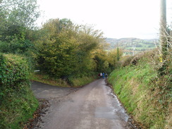
From the car park, it was a simple case of following the narrow single-track road downhill. This was surprisingly busy, and on several occasions we had to stop as descending and ascending cars performed intricate ballets to get past each other. My thighs started aching once more during the descent, and I started to feel ill once more. It was a relief when the narrow road ended at the main road at the bottom of the hill. Charmouth was a short distance away; neither of us felt like travelling down to the sea front, and instead we walked up to the George pub. We went in and ordered a half each, and we also asked for information about taxis.
What followed was a funny little situation; the first taxi firm we called seemed happy enough to take us, before rolling back and suggesting another number that turned out not to exist. Fortunately the people in the pub told us that a bus was due soon, so we drunk up and headed down to the bus stop. I was feeling a great deal better by this time, and the trip on the top deck of the bus was great fun. It dropped us off at the Bull Inn in Swyre, and we were left with a mile's walk down to the car at the seafront. We got in, and I immediately started feeling really ill. Fortunately Sencan was driving, and she did a good job of keeping the car on the road whilst I retched to Radio Four. It was an interesting end to what had been a good day's walk over some wonderful scenery.
 |
 |
|
Directions
This leg starts off at the car park in West Bexington. Head northwestwards for 0.8 miles, running along a good path behind the shingle bank of Chesil Beach. On the way, the path passes the West Bexington Nature Reserve. At about SU520871 the path diverts to the right, crosses a footbridge and then turns to the left. From here it runs northwestwards behind the pleasant Burton Mere to rejoin the shingle behind Cogden Beach.
A good path heads west-northwestwards below the cliffs to the right; at SY500882 it climbs up onto the top of the low cliffs. From there it skirts to the seaward side of a caravan park at the Old Coastguard House. Soon afterwards the summit of the cliffs is reached, and the path parallels the cliff edge a few yards inland. It becomes wider as it descends down to reach a car park behind Burton Beach.
Walk past the car park and then the café. The path quickly climbs the cliffs behind the beach, initially with a fence protecting it from some buildings immediately inland. When these end, the path continues on with the aptly-named Cliff Road on the right. This soon curves to the right to head inland; continue on as the path sticks near to the cliff edge over Burton Cliff. This stretch of path is far from level, with a couple of minor dips to be negotiated.
Burton Freshwater is reached at SY479895. Just before the water is reached, the path turns sharply to the right to head across a field, curving slowly to the right and descending to reach a small footbridge over the river at SY482895. Cross this bridge and a stile, and then aim half-left across a field for a short distance to a hedge. Pass through this to enter a caravan park. Turn to the left and follow the edge of the park westwards. The path leaves the park at its southwestern corner; continue on across a field with the river on the left to reach Burton Freshwater beach.
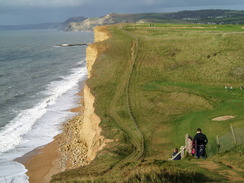
If the tide is low then this beach can be followed all the way to West Bay; otherwise, the path skirts the southern edge of another caravan park; the shingle is hard to walk over, so it is best to keep near to the caravan park. Once the park ends, the path climbs up onto East Cliff, initially with a golf course on the right. There are a couple of significant dips to be negotiated as it squeezes between cliff edge and golf course. Eventually the cliffs lower to reach the beach in West Bay.
When the beach is reached, turn right to head north, passing a car park on the left. Continue on until a road is reached at SY494903. Turn left and follow this road westwards. This road curves to the right to pass the eastern end of West Bay Harbour. Shortly afterwards it curves to the left to head westwards along the northern end of the harbour to reach a roundabout.
Head south from the roundabout down the Quayside, keeping the harbour to the left until the Esplanade is reached. Turn right and follow the Esplanade west-northwestwards. At SY459904 turn right up some steps to leave the promenade and take the a path that starts ascending the cliffs, with a housing estate to the right. Once the houses end the path continues on northwestwards across a field, heading away from the cliff edge. It meets the corner of another field; continue on with the hedge on the right to rejoin the cliff edge once more.
The path continues climbing westwards, roughly paralleling the cliff edge before descending to Eype Mouth. Cross the stream using the footbridge, and on the western side turn right to ascend some steps to a car park. Continue on northwards for a few yards past the car park until a road is reached, and just before the first building on the left, turn along another footpath. Initially this heads westwards, before leaving the cliff edge.
The path soon descends down into a small dry valley, before rejoining the cliff edge for the ascent up Thorncombe Beacon, from where it continues in a westerly direction, sometimes near to the cliff edge and at others slightly further away as it ascends Doghouse Hill and then Ridge Cliff. After Ridge Cliff it descends down near to the cliff edge to reach a car park at Seatown. Cross the footbridge to gain access to the western side of the stream; the Anchor Inn is a few yards away on the left.
Coastal erosion has had a considerable effect upon this area, and diversionary routes have been made. For this reason, it is best to follow any signs on the ground rather then these directions for the ascent up Golden Cap, which were correct in the autumn of 2010. Fortunately, the path on the ground is well-walked and obvious. Turn right and follow Sea Hill Lane northwards; it soon curves to the left at the entrance to a caravan park. At SY420919 the SWCP leads off to the left across a stile into an area of scrubby bushes. It heads westwards for about a hundred yards, before emerging into a field. Turn left around the edge of this field, and follow it as it turns to the right to head northwestwards. At the western end of this field, the path plunges into a small patch of woodland. It winds southwestwards through the trees to reach a corner of fields.
Continue straight on past the corner of the field and follow an obvious path that soon curves to the right to head uphill northwestwards. After a while the path curves to the left and then to the right, to enter a narrow band of trees. Leave the trees and enter an area of clear land. It continues to climb northwestwards, before curving to the left across the field. A hedge is joined on the left; soon the path passes through this and continues west-northwestwards. It plunges through another hedge and heads northwestwards with another hedge on the left; after a couple of dozen yards the path turns to the left and plunges through the hedge. Steps take it curving uphill to reach the trig pillar at the summit of Golden Cap.
Take the obvious path that heads southwestwards from the trig pillar, soon reaching steps that zig-zag down the steepest part of the hill. At the bottom of the steps, the path assumes a more westerly course. The path heads through a hedge and continues on, sticking close to the edge of the cliff until about SY398922, where it turns to the right to head inland northwestwards. Steps descend down into the little valley that leads into St Gabriel's Mouth and cross a footbridge before climbing up the other side. When it emerges from an area of scrubland, do not take the obvious path that heads off to the left towards the sea. Instead, continue straight on west-northwestwards across a field. The path becomes more obvious as it crosses a couple of fields, before curving gently to the left near Ridge Barn at SY391926.
The path descends westwards with a hedge on the right; this slowly curves to take a more west-southwesterly course. It plunges down steps into a small area of scrubland that surrounds a stream called Ridge Water; on the other side it climbs up more steps and turns sharply to the right to head northwestwards to a hedge at SY387927. It then curves to the left once more to head southwestwards, descending slightly to reach Westhay Water.
Cross Westhay Water and start a long ascent up to the top of Stonebarrow Hill. Initially this heads westwards, but when the cliff edge is reached once more it turns to the right to head northwestwards across a field. It crosses a hedge at the midpoint (do not take the path that heads towards Westhay Farm). Continue on along the obvious path, aiming for some steps that lead steeply up towards the top of Stonebarrow Hill.
Another diversion starts a few yards further on at SY378930. Turn right to start following a footpath that heads northeastwards for a fifth of a mile with a field boundary on the left. The path ends at a car park beside a road at SY380932. Turn left and start following this road in a rough westerly direction. After three-quarters of a mile it meets a road at Newlands Bridge over the River Char. Head straight on along this road for a fifth of a mile, crossing the river bridge and continuing on for another couple of hundred yards until the George pub is reached on the right, where this walk ends.
 |
 |
|
Distances
| From | To | Distance (m) | Ascent (ft) | Descent (ft) |
|---|---|---|---|---|
| West Bexington | West Bay | 5.7 | 1440 | 1460 |
| West Bay | Charmouth | 7.8 | 2457 | 2418 |
This makes a total distance of 13.5 miles, with 3897 feet of ascent and 3878 feet of descent.
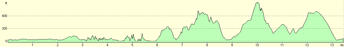
For more information on profiles, ascents and descents, see this page
Transport
The X53 Jurassic Coast bus service runs bus services between Charmouth and the Black Bull pub, on the hillside above West Bexington. It is a mile walk from the Black Bull to the car park in West Bexington. The bus stop in Charmouth is about a hundred yards to the east (downhill) from the George.
 |
 |
|
 |
 |
|
 |
 |
|
 |
 |
|
 |
 |
|
 |
 |
|
 |
 |
|
 |
 |
|
 |
Disclaimer
Please note that I take no responsibility for anything that may happen when following these directions. If you intend to follow this route, then please use the relevant maps and check the route out before you go out. As always when walking, use common sense and you should be fine.
If you find any information on any of these routes that is inaccurate, or you wish to add anything, then please email me.
All images on this site are © of the author. Any reproduction, retransmissions, or republication of all or part of any document found on this site is expressly prohibited, unless the author has explicitly granted its prior written consent to so reproduce, retransmit, or republish the material. All other rights reserved.
Although this site includes links providing convenient direct access to other Internet sites, I do not endorse, approve, certify or make warranties or representations as to the accuracy of the information on these sites.
And finally, enjoy your walking!
Nearby walks
| # | Title | Walk length (miles) |
|---|---|---|
| 318 | Wyke Regis to West Bexington | 14.3 |
| 319 | West Bexington to Lyme Regis | 15.5 |
| 320 | Lyme Regis to Sidmouth | 16.0 |
|
|

|