Walk #872: Charmouth to Seaton
 |
 |
|
General Data
| Date Walked | 06/11/2010 |
| County | Dorset, Devon |
| Start Location | Charmouth car park |
| End Location | Seaton bus stop |
| Start time | 09.07 |
| End time | 14.49 |
| Distance | 11.9 miles |
| Description | This was a very pleasant walk along the coast, depsite the sea being out of view for the majority of the time. |
| Pack | Today I carried my 30-litre Karrimor rucksack, filled with water, my waterproofs, a couple of books and other odds and ends. |
| Condition | I feel absolutely fine after this walk. |
| Weather | Today was a surprisingly warm day for the time of year, with a mixture of sunshine and cloud. |
| OS map | Landranger number 193 (Taunton & Lyme Regis, Chard & Bridport) |
 |
 |
|
Map of the walk
Maps courtesy of Google Maps. Route for indicative purposes only, and may have been plotted after the walk. Please let me have comments on what you think of this new format. For a detailed table of timings for this walk, please see the table file.
 |
 |
|
Notes
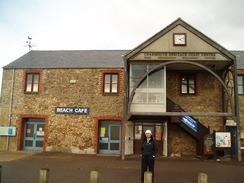
After last week's exhilarating if eventful walk, we felt like getting another day of the South West Coast Path done. The days are getting ever shorter, so we set off early and arrived in Charmouth well before nine. We drove down to the seafront; the gates guarding a car park were being opened; and the one by the seafront was £4 for the day. Instead, we drove partway back up the hill to a car park with a toilet block. It only took us a few minutes to get ready, and we were then heading up the hill to reach the main road through the village, strangely called The Street. We headed down this, passing the George where we finished the last walk, before rejoining the South West Coast Path.
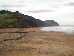
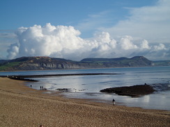
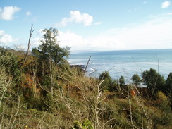
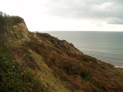
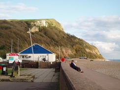
A narrow path took us down towards the sea, where we reached the heritage centre. The views east past the 2009 landslip towards Golden Cap were superb, and we stopped to drink them in, knowing that we would not get many more sea views today. This website has a wealth of information on the landslips in the area, and the risk they pose to Lyme Regis. Eventually we tore ourselves away from the views, and headed past the heritage centre and then up a lane back to The Street. From here it was a long road walk uphill; there were pavements that meant that the walk was not too dangerous, but the ascent started to get steeper past the hotel.
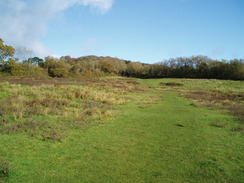
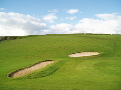
It was a slight relief when the trail left the road and plunged into an area of woodland. Initially the path was surprisingly hard to find amongst the carpet of recently-fallen leaves, but as it climbed it became firmer and more obvious. Soon we emerged out onto a golf course. Short white posts guided us across the course, A few people were around, and we switched off our MP3 players so we could hear any warnings. It was turning out to be a beautiful day, but it felt good to be at the top of the first - and highest - climb of the day.
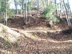
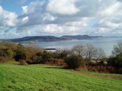
A road took us downhill from the car park, and then a strange stretch of path led off through an area of woodland. It was hard to find exactly where the path passed through this section of rough ground, which looked as though diggers had scooped out large sections of earth and dumped them around before the trees had grown - perhaps it was an old quarry. From the map it was obvious that the path headed downhill to a track, so we headed through the trees in roughly the right direction. Somehow we ended up right above the correct stile. The path across the fields was easy to find in comparison to that in the trees, and the views down over Lyme Regis and the sea were uplifting.
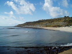
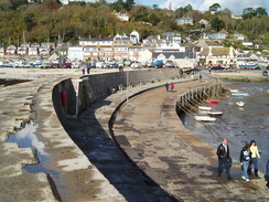
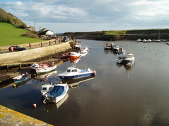
The path ended and a road continued downhill into the centre of Lyme. We squeezed past the tourist information office onto the seafront, and were greeted with some grand views back up the coast towards Charmouth and Golden Cap. Lots of people were about in the sunshine, enjoying a stroll along the promenade. Lyme Regis is a lovely place, a seaside resort that had not lost its charm. Perhaps it is the literary connection - The French Lieutenant's Woman and Jane Austen's Persuasion - had awarded it some protection. Ahead lay what was perhaps the town's most famous landmark - the Cobb, the massive walls guarding the harbour.
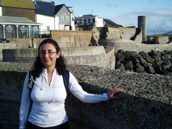
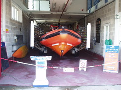
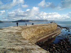
We stopped off at the Cobb beside the lifeboat station to eat our sandwiches, as a plague of flies swarmed around us. We tried to concentrate on the views rather than the flies, but it was still a relief when was had finished our sandwiches and we could continue on. People were arranging wood ready for the fireworks display in the evening, but unfortunately we would be well away by then. Instead of heading on along the coast path, we initially headed to walk along the long southern breakwater. The top surface of this slopes fairly steeply and could be dangerous in wet and stormy weather. It can only be a matter of time before health and safety causes handrails to be erected, or the path over the top closed. Either of these options would be a travesty. We admired the views from the end for a while, before heading back to land. The trail headed past a bowling green and into a car park.
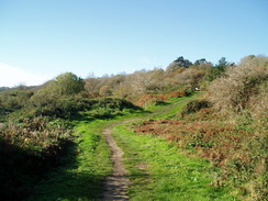
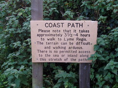
Steps led uphill through an area of scrubland. It was steep, but the views from the top were well worth the exertion. A slighter ascent continued uphill, and we stopped by a bench to drink in the views back over Lyme Regis. After passing Underhill Farm the path plunged into the trees that we would be following for most of the rest of the day. Soon we reached a sign, stating that Seaton was 3.5 to 4 hours away. Since it was only about seven miles, we decided to see if we could thrash this time.
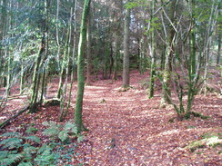
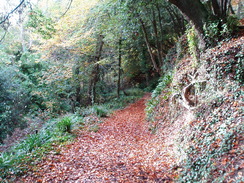
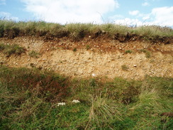
Almost the entire walk between Lyme Regis and Seaton is through the Dowlands Cliffs and Landslips, also known as the Undercliffs. This is an area of geologically unstable land that is slowly and continually slumping into the sea. The last large slump occurred on Christmas Day 1839, when a massive landslip occurred, with an estimated eight million tons of rock being displaced and forming a chasm three-quarters of a mile long. Smaller landslips occur to this day, and this means that the land is fortunately undeveloped. I say fortunately, because we have been left with an area of land that is not used for agriculture or industry, meaning that it is a Jurassic-park style wonderland of trees. The only ways into and out of the area is via the South West Coast Path, and the path is kept open despite the slumping; for this reason, always follow the path indicated through the reserve.
Unfortunately the conditions were not ideal. Last time I walked along this stretch of path the ground was frozen, but today the mud was thick and gloopy. To make matters worse, a carpet of brown and orange leaves covered the mud, making the path exceptionally slippery. Perhaps because of the continual slumping, the contour lines on the OS maps are not that accurate, and the path is far more strenuous than appears at first. There are no major ascents or descents, but you are continually climbing and falling along the path. A whole series of steps, made slippery by the mud, led us up and down and we were soon both sweating heavily.
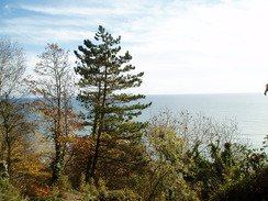
Occasional glimpses over the sea were made visible, which glittered in the sunshine. In other places, high white cliffs inland showed the scale of the landslips. I doubt that there was a single flat area of land of more than a few hundred metres around; the entire area was a jumble of blocks of rocks It was turning out to be an unseasonably warm day, but fortunately we had plenty of water with us. The conditions underfoot meant that we were going slower than I had expected, but eventually we reached a long flight of steps that led uphill. At the top the path walked below the edge of a field; below, because a small cliff to our right there were obvious signs that the path had slumped down from below.
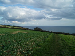
A little under three hours after we left Lyme Regis, we reached another board saying that the walk there took 3.5 to 4 hours. We had beaten the time, but not by as much as I had hoped. After this the walking was easy; the path crossed a field, before descending down a track and crossing a golf course. The small resort of Seaton soon became visible ahead. A modern bridge carries the main road over the River Axe to the east of the town, but the path crosses the older bridge immediately adjacent. This is a fairly historic bridge, as it is the oldest surviving concrete bridge in England, having opened in 1887 and been replaced by the modern bridge in 1990.
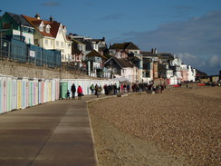
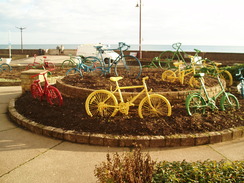
Seaton was just how I expected it to be - pretty, but slightly run-down in the late autumn. We sat on a bench for a few minutes and considered continuing on over the cliffs to Beer, but that would have further shortened the short walk to Sidmouth the next day. Instead, we walked on and found the bus stop, which was beside a roundabout by the sea front. An unusual addition had been made to the roundabout - a number of old bicycles, each painted a different, bright colour. As there was an hour to go before the bus arrived, we walked around a while, exploring the town, before settling down for a drink at a cafe. It had been a rewarding day's walk, and the highlight had to be the strenuous but interesting walk though the landslip area.
 |
 |
|
Directions
This walk starts off at the car park in Lower Sea Lane in Charmouth, at SY364934. As we finished the last walk at the George Inn in Charmouth, we left the car park and turned left to head uphill to reach the main road through the village, The Street. Turn right and follow The Street eastwards downhill. Just before Manor Farm is reached on the left, turn right down Bridge Road, which curves to the right at the fire station to head south. As the road curves to the right once again, take a footpath that heads off to the left, heading south-southwestwards with a caravan park on the left. Initially this runs between two hedges, before the hedge on the left becomes a fence guarding the path from the caravan park. The path becomes a road, River Way, which leads on to end at Lower Sea Lane. Turn left down this road until it reaches the sea with a car park on the left at SY364930.
The coast path has been diverted here in recent years, meaning that the stretch as far as Lyme Regis heads far inland. If the tide is low then it is apparently possible to walk along the beach to Lyme Regis, although as always care should be taken. Turn right to squeeze past seaward of the Charmouth Heritage Coast Centre. Immediately afterwards turn right up a slope to pass the toilets, and then cross a grassed area to join a path that heads northwestwards. The path becomes a surfaced track that eventually meets Higher Sea Lane. Head north along this road for a fifth of a mile until it ends at a T-junction with The Street. Turn left and start following this road west-northwestwards for nearly half a mile until it ends at a roundabout with the A35(T) at SY355938.
Take the first road off to the left at the roundabout, the A3052; there is a pavement on the right-hand side of the road. This climbs uphill for a third of a mile. When an area of woodland starts on the left, turn left through a gap in the hedge and immediately turn half-right to enter the trees. A path climbs gently uphill through the trees, ascending onto Fern Hill. It initially parallels the distant boundary of the hotel's grounds, before climbing more steeply and emerging from the trees at SY350938. Turn half-right to take a more westerly course across Lyme Regis Golf Course. It is best to follow the indicated route straight across the course, which follows white posts and blazes on the trees. The path reaches the A3052 road at SY346937; turn left to start heading south-southwestwards along the road. After a short distance the road curves to the right; at the bend continue straight on down Timber Hill. Initially it heads southwestwards before curving to take a more southerly course.
Just before the road curves to the right at SY344931, turn left through the hedge to join a footpath. The next stretch of route is fairly difficult to trace; initially head straight on eastwards through the woodland, across ground that is dominated by bumps and hollows. Soon turn right to start heading downhill, joining a track at the bottom of the woodland near the road. Turn left to head eastwards along the track for a few yards, before turning to the right to cross a stile and head south downhill. The path reaches a hedge; turn half-right to head southwestwards, heading through another hedge until the A3052 is reached once more at SY343927. Turn left and follow the main road downhill for nearly half a mile until the seafront in Lyme Regis is reached; there are pavements on both sides of the road. When the road curves to the right by the Tourist Information office, continue straight ahead under a building to reach the seafront. Turn right and descend to join the promenade.
Start following the promenade southwestwards. Pass the Cobb and continue on until Cobb Road is reached, beside the Cobb Arms. Cross westwards down Cobb Road, passing the lifeboat station and then a car park on the left. Pass the Lyme Regis Bowling Club on the right and then continue on for a few yards into a car park, before turning right to head north with the bowling green on the right. After a few yards, climb some steps with houses on the right; after a few yards this reaches a road. Cross this and continue on along the other side to join a footpath. Steps climb steeply uphill through an area of scrubland.
The path heads northwestwards, slowly ascending as it does so. Another path is reached at SY335917; here turn left and follow this new path in a rough west-southwestwards direction. It soon curves to the right to head northwestwards; at SY330917 a track is reached. Follow this southwestwards towards Underhill Farm. From here it enters the Undercliffs, the large expanse of landslips that occurred on Christmas Day 1839. The next six miles are dominated by various historic landslips as the path gently rises and falls. Due to the precarious nature of the land, the path through the reserve can be moved around as and when necessary. The path is easy to find on the ground and it is hard to go wrong; there are few paths leading off from the path through the reserve, and always try to keep on the main path.
Eventually a long flight of steps lead uphill. through a more open area of land. The path finally emerges from the landslips at SY270895. Continue on westwards below the edge of a field; the path curves to the right to head northwestwards across a field to reach the end of a green track called Stony Close Lane. Turn right and follow this track northwards for a quarter of a mile, eventually with a golf course for company on the left.
This track ends at a T-junction with another track called Barn Close Lane. Turn left and start following this lane westwards for nearly two-thirds of a mile; it soon disappears at the golf course, which can be crossed with care. Aim downhill for the gap between two white buildings. Go between them, and then cross the car park to join Squire's Lane. This descends rapidly to end at the B3172 road. Turn left and follow this main road as it curves to the right to cross a bridge over the River Axe (use the old Axmouth Bridge immediately on the left rather than the main road bridge). When Trevelyan Road is reached on the left, turn left to follow it down for fifty yards to reach the seafront in Seaton. Turn right and follow the seafront westwards through Seaton for a third of a mile until a roundabout is reached at SY244898.
 |
 |
|
Distances
| From | To | Distance (m) | Ascent (ft) | Descent (ft) |
|---|---|---|---|---|
| Charmouth car park | The Cobb, Lyme Regis | 4.7 | 673 | 738 |
| The Cobb, Lyme Regis | Seaton | 7.2 | 1729 | 1709 |
This makes a total distance of 11.9 miles, with 2402 feet of ascent and 2447 feet of descent.
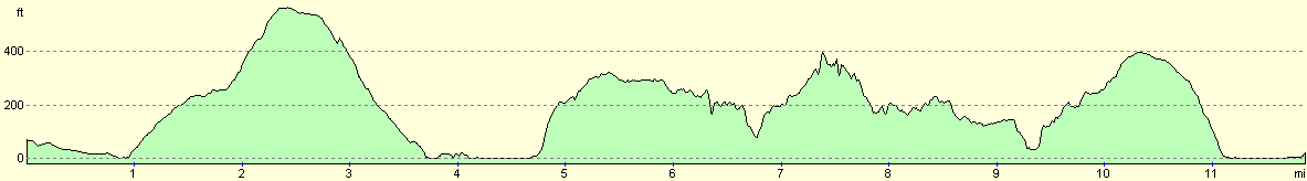
For more information on profiles, ascents and descents, see this page
Transport
The X53 Jurassic Coast bus service runs bus services between Seaton and Charmouth via Lyme Regis.
 |
 |
|
 |
 |
|
 |
 |
|
 |
 |
|
 |
 |
|
 |
 |
|
 |
 |
|
 |
 |
|
 |
Disclaimer
Please note that I take no responsibility for anything that may happen when following these directions. If you intend to follow this route, then please use the relevant maps and check the route out before you go out. As always when walking, use common sense and you should be fine.
If you find any information on any of these routes that is inaccurate, or you wish to add anything, then please email me.
All images on this site are © of the author. Any reproduction, retransmissions, or republication of all or part of any document found on this site is expressly prohibited, unless the author has explicitly granted its prior written consent to so reproduce, retransmit, or republish the material. All other rights reserved.
Although this site includes links providing convenient direct access to other Internet sites, I do not endorse, approve, certify or make warranties or representations as to the accuracy of the information on these sites.
And finally, enjoy your walking!
Nearby walks
| # | Title | Walk length (miles) |
|---|---|---|
| 319 | West Bexington to Lyme Regis | 15.5 |
| 320 | Lyme Regis to Sidmouth | 16.0 |
| 855 | Rampisham Down to Marshwood | 19.6 |
|
|

|