Walk #873: Seaton to Sidford
 |
 |
|
General Data
| Date Walked | 27/11/2010 |
| County | Devon |
| Start Location | Seaton bus stop |
| End Location | Sidford |
| Start time | 09.30 |
| End time | 15.10 |
| Distance | 12.4 miles |
| Description | This is a strenuous walk along the cliffs of East Devon. |
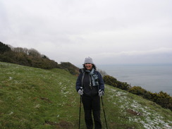
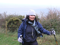
| Pack | Today I carried my 30-litre Karrimor rucksack, filled with water, my waterproofs, a couple of books and other odds and ends. |
| Condition | I feel absolutely fine after this walk. |
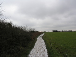
| Weather | Today was a cold day, wih a northerly wind that was bitter when we were exposed to it. A scattering of snow lay on the ground, and the clouds threatened more, but fortunately it neer came. |
| OS map | Landranger number 192 (Exeter & Sidmouth, Exmouth & Teignmouth) |
 |
 |
|
Map of the walk
Maps courtesy of Google Maps. Route for indicative purposes only, and may have been plotted after the walk. Please let me have comments on what you think of this new format. For a detailed table of timings for this walk, please see the table file.
 |
 |
|
Notes
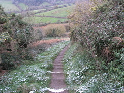
About a month ago, Sencan and I decided to try and walk as far as Exmouth along the South West Coast Path. We have now reached Seaton, and had two days of walking to complete this task. As we were about to enter December, it seemed like a good idea to get another walk done. Unfortunately the weather forecast was not ideal; it would be bitterly cold with snow possible anywhere. Sprinklings of snow appeared on the hillsides as we drove westwards, and heavy, snow-laden clouds lay overhead.
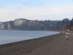
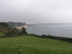
We parked at the large car park beside the tramway in Seaton, got our kit together and walked over to the nearby Co-Op to buy some more food for the day. My pack already felt quite heavy with the bag of food Sencan gave me to carry for the day, and so I was glad when she stuffed it into her own rucksack. As we strolled down towards the seafront it was clear that it was not going to be a good day for photography, with hazy skies spoiling the views.
the first part of the day was an easy troll along the promenade to a chine, where we headed along a road towards Beer. A couple were walking ahead of us, and as we veered along the old path they continued along the road. We would see them occasionally for the rest of the day, stick figures on the hillsides ahead of us. There were some pleasant views from the looping path above Beer, and off to the left were the remains of an old surfaced path that had fallen claim, in part, toe cliff falls.
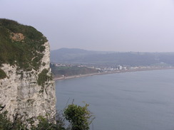
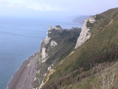
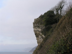
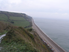
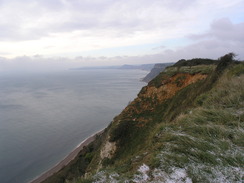
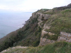
A long flight of steps led down into Beer, the descent seeming longer than the ascent had been this morning. Beer is a lovely little town and is well worth an explore, but our route took us back up onto the cliffs. It took a while for the cliff edge to be reached once more, bit when we did we were rewarded with views back over Beer and Seaton. I had intended to stop at Beer Head, but we passed the headland without noticing it and soon we were at the first decision point of the day. The path splits just to the west of Beer Head; the official path heads down into the Hooken Undercliffs, another one of the massive landslides that bedevilled the area. The upper path continues along the cliffs, and easier route that affords better views.
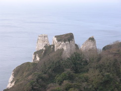
After a quick conflab we decided to take the lower path, which descends down steps into a little wonderland wilderness, with trees guarding views from the sea. The Hooken Undercliffs are ten acres of ground that collapsed from the cliffs in 1790, leaving large blocks of rock lying at all sorts of angles. It is not as spectacular as the six miles of cliffs to the west of Lyme Regis, but the going is easier and there are less ascents and descents, making it a very pleasant stroll. The frozen ground meant that we were not slipping and sliding in mud.
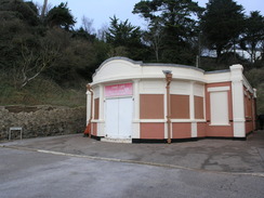
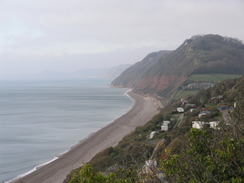
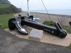
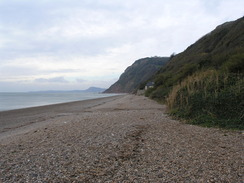
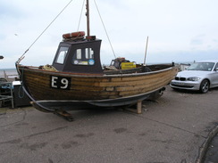
The path led us out into an area of scattered static caravans, each of which must have great views of the sea, and then down to Branscombe Mouth. This quiet hamlet gained fame in 2007 when the 62,000-ton freighter MSC Napoli got into trouble in the channel. It was grounded off Branscombe beach, and containers were washed off as it started to break up. Scavengers collected salvage off the beach, including many diverse items such as motor cycles. The ship was finally broken up in July 2009, meaning that the only sign of it was an anchor displayed outside the cafe.
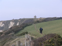
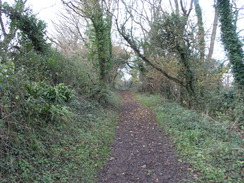
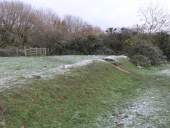
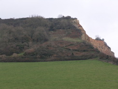
We nipped into the cafe for a bite to eat, during which we had a nice chat with a couple of local ladies. Unfortunately winter does not allow too many stops, and so we were soon heading off once more, this time climbing the West Cliffs. The path mainly runs through trees, and is fairly bitty, although easy to follow on the ground. It was a relief when we reached the ramparts of the Iron-age hillfort of Berry Camp. Half of this has already been lost to the sea, and I wonder how far it was from the cliff edge when it was originally constructed. To be frank it was fairly unimpressive, with ramparts that looked to be little more than small banks and ditches. It is certainly not a Maiden Castle.
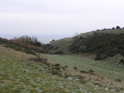
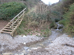
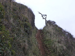
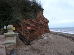
The path diverted inland of a dry valley and descended steeply to the shingle beach at Weston Mouth. This was the only time that we actually walked on the beach all day, and that was for all of about twenty feet as the path crossed a stream before climbing up some wooden steps. Another steep ascent followed up yet more steps onto Lower Dunscombe Cliffs. Almost immediately the path diverted inland of the dry Lincombe valley, and then a marvelous level stretch allowed our legs to recover.
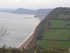
Unfortunately all too soon we were descending down another steep slope, this time towards South Coombe. We were relieved to find that the path does not divert down to the beach, and instead soon climbs uphill steeply once more. My legs were aching on the ascent, which we took slowly to what was a very short plateau. All too soon we were on the last descent of the day towards Sidmouth. The original path followed the cliff edge, but erosion has caused a diversion inland along tracks and minor roads. These diversions are thankfully not too long, and all too soon we were crossing the footbridge over the River Sid to enter the village.
I looked at the bus timetable during the descent, and realised with disgust that I had misread the timetable. I had assumed that the X53 Exeter to Weymouth bus called at Sidmouth; instead, it calls as Sidford, which lies about two miles inland. We guessed that other busses might do the job, but to be safe we decided to walk north. We had about fifty minutes to walk before the bus, but we had to find the bus stop at the other end. A fast stroll was not too bad on tired legs, but our pace meant that the walk was a heads-down affair, with little chances to study the surroundings. Our hard work was rewarded, and we arrived at the bus stop about ten minutes before the bus was due.
The fast walk had tired us both out, and the cold weather soon had us shivering. As ever the X53 bus was punctual, and we were soon sitting on the top deck as it wound its way eastwards. On the bus we opened our bags of food for the first time, and I found a large bottle of mouthwash in mine. Sencan had forgotten to remove it from the plastic bag before handing it to me, and I had lovingly carried it up and down the hills. The extra weight made for some good practice for my hiking trips, at least, and at least I knew I would have fresh breath for the next few weeks.
 |
 |
|
Directions
This leg starts off at the roundabout in Seaton at SY244898. There are two routes that can be followed from here. The upper route follows Castle Hill westwards from the roundabout, and when it curves to the right join a surfaced path. This heads westwards along the top of the cliffs before it curves to the right and descends to reach a path at SY240898, just above the Chine Cafe. For the lower route, join the promenade at the roundabout and continue westwards until the Chine Cafe is reached.
If the tide is low, then the beach can be followed westwards from the Chine Cafe to Seaton Hole; naturally, care needs to be taken. Only take this route if you are sure of the tides and weather conditions. At Seaton Hole, take a path that leads up to the road at SY234896.
The official path heads northeastwards from the cafe up the chine. Follow the path as it curves to the left and then right, climbing some steps. This path emerges out onto the B3174 Beer Road at SY240899. Turn left and follow Beer Road westwards for a couple of hundred yards until Old Beer Road leads off to the left. Follow Old Beer Road southwestwards for a quarter of a mile, descending down towards Seaton Hole. Take Beer Hill when it leads off to the left. This climbs uphill for a hundred yards, and then turn left up a slope to join a footpath. At the top join a good surfaced footpath that runs along the edge of a field before turning to the right to head southwards along the edge of the cliffs between hedges. It climbs uphill before falling, and after a third of a mile it curves to the right to head westwards. The path then descends down steep steps to meet a track by some toilets that soon meets Fore Street in Beer.
Cross Fore Street and continue straight on along Common Lane, which immediately curves to the right past the Anchor Inn. Continue on uphill along Common Lane southwestwards with houses on the right; when Southampton Road comes in from the right at SY228889 turn left down a surfaced road called Little Lane (do not head into the car park). Initially this is a lane past houses, before it narrows into a sunken path; after a fifth of a mile the path curves to the left to head southeastwards with a hedge on the right guarding a caravan site.
The path curves to the right to join the cliff tops and starts to climb southwards towards Beer Head. It moves slightly away from the cliff edge as it does so, but the path underfoot is good and easy to follow. It reaches Beer Head at SY225879. Here the path turns to the right to start heading westwards, initially along the top of the cliffs. After a fifth of a mile at SY222880 you have a choice of routes.
The lower route heads off across a stile to the left, plunging down steps below Hooken Cliffs. The path is easy to follow westwards through the base of the undercliffs for a mile; after the initial descent the going is relatively flat, except for one short climb and descent down steps. The path eventually joins a track beside static caravans that are scattered over the hillside; head westwards down this track until it emerges into a field at SY209881. Here the track curves to the right; leave it and head straight on westwards down a field to reach a clappergate that gives access to the road at SY207881 at Branscombe Mouth.
The upper route continues along the top of the cliffs, passing seaward of the Old Coastguard Lookout at SY219881. You can either follow an obvious path along the cliff edge, or the bridleway which runs further inland with a hedge on the right. When an area of brushland is reached turn left and start heading steeply down East Cliff. It crosses a field westwards to gain access to a clappergate that leads out onto a road at SY207881 at Branscombe Mouth.
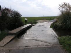
Join the road at Branscome Mouth and turn left, keeping the car park on the right. The road crosses a ford; there is a footbridge on the left that allows you you to keep your feet dry. Immediately after passing the cafe on the right, turn right along a footpath that heads northwestwards across a field (ignore the track immediately on the right). The path skirts the grounds of a hotel on the left, and then curves to the left across another field. It starts to climb uphill westwards through some scrubland.
Near the top of the cliff the path starts to head slightly inland and then heads westwards across a series of fields, crossing the ramparts of the Iron-age hillfort of Berry Camp and skirting inland of a dry valley called Littlecombe Hollow. The path is easy to find on the ground and is well waymarked. It then turns slightly to the left to head back towards the edge of the cliffs, reaching it at SY176880 on Coxe's Cliff.
From there, it follows the edge of the cliff westwards past Weston Cliff before starting the descent down to Weston Mouth. The descent is steep down steps; initially the path heads inland slightly to the right for a short distance through some scrubland before turning to the left to head back towards the cliff edge. It then heads diagonally across a field; at the western end turn left down a track that leads to the sea at Weston Mouth.
Turn right to head west along the beach for a few yards, crossing a stream. Immediately afterwards turn up some wooden steps and starts to climb uphill along a stepped path. It sticks close to the edge of Lower Dunscombe Cliffs before diverting inland around the Lincombe Valley; the descent here is not at all strenuous or steep. When the sea cliffs are reached once again, continue westwards with the cliff edge on the left; cliff falls may mean short diversions inland. Soon yet another valley is reached; the path zigzags down steps down the first section, then follows the cliff edge to the bottom. At the bottom, turn right to follow the edge of the field northwards until a footbridge Cross the footbridge and turn left to start following the edge of a field southwestwards to regain the cliff edge. Ignore the path that leads off to the left towards the beach, and instead turn right and follow the cliff edge uphill along yet more steps. Once at the top, follow the cliffs westwards on a thankfully level stretch; just after the end of a field on the right, the path heads off to the half-right for a short distance before curving to the left and entering an area of scrubland, falling steeply down steps. It regains the cliff edge and continues downhill. At SY132874 turn right along a track with a hedge on the right; it enters another field with a hedge on the left. The track soon reaches a junction with Laskeys Lane on the left; turn left and follow the lane westwards for about 150 yards.
When Laskeys Lane curves to the right continue straight on down a narrow lane. This immediately curves to the left to head south for a hundred yards, until it curves to the right to head westwards, with a series of houses on the left. The road curves to the right 200 yards after the bend, continue straight on to join a surfaced path. This immediately curves to the left and descends downhill to reach a footbridge over the River Sid at SY129873. Note; the old stepped path down to the footbridge has been closed, and has been replaced by a surfaced slope.
On the western side of the footbridge, turn right and walk westwards through a car park to reach Ham Lane. Turn right and follow the lane northwards, and then take the first road off to the right, York Street. Turn right up Mill Street and then left along Holmdale to reach the High Street. Turn right to start heading north along the A375 for 1.7 miles; when the road forks, take the right-hand fork that continues northwards. When the road meets the A3052, turn right for a few yards to a bus stop opposite the Spar shop.
This makes a total distance of 12.4 miles, with 3280 feet of ascent and 3173 feet of descent.
The X53 Jurassic Coast bus service runs bus services between Sidford and Seaton.
Please note that I take no responsibility for anything that may happen when following these directions. If you intend to follow this route, then please use the relevant maps and check the route out before you go out. As always when walking, use common sense and you should be fine.
If you find any information on any of these routes that is inaccurate, or you wish to add anything, then please email me.
All images on this site are © of the author. Any reproduction, retransmissions, or republication of all or part of any document found on this site is expressly prohibited, unless the author has explicitly granted its prior written consent to so reproduce, retransmit, or republish the material. All other rights reserved.
Although this site includes links providing convenient direct access to other Internet sites, I do not endorse, approve, certify or make warranties or representations as to the accuracy of the information on these sites.
And finally, enjoy your walking!

Distances
From To Distance (m) Ascent (ft) Descent (ft) Seaton Beer 1.8 449 404 Beer Branscombe Mouth 2.3 781 817 Branscombe Mouth Sidmouth 6.2 1896 1919 Sidmouth Sidford 2.1 154 33 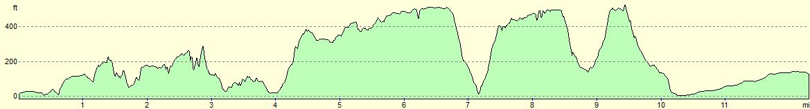
For more information on profiles, ascents and descents, see this page
Transport
Disclaimer
Nearby walks
# Title Walk length (miles) 319 West Bexington to Lyme Regis 15.5 320 Lyme Regis to Sidmouth 16.0 321 Sidmouth to Lympstone 15.3
![]() Previous walk
Previous walk
![]() Next walk
Next walk
