Walk #449: Wigtown to Isle of Whithorn
 |
 |
|
General Data
| Date Walked | 21/05/2003 |
| County | Dumfries and Galloway |
| Start Location | Wigtown |
| End Location | Isle of Whithorn |
| Start time | 10.34 |
| End time | 18.33 |
| Distance | 20.3 miles |
| Description | This was quite a long and strenuous day over terrain that should have been better than yesterday's long road trudge, but it was let down by the weather. |
| Pack | Today I carried my 30-litre Karrimor HotRock rucksack, which was filled with my packed lunch, waterproof leggings, water bottle and a couple of spare shirts, together with the usual assortment of odds and ends. |
| Condition | I am quite tires, but otherwise I feel absolutely fine after this walk. I had no trouble with either of my ankles or my right shoulder, and as this has been the case for several days I am quite happy that these problems are over. |
| Weather | This morning was quite bright at times, but as the morning went on the clouds started to gather until at lunchtime it started to rain, and it did not stop for the rest of the day. Fortunately it never really poured, but it was a light, continuous rain that was in its own way quite depressing. |
| OS map | Landranger number 83 (Newton Stewart & Kirkcudbright, Gatehouse of Fleet) |
 |
 |
|
 |
Map of the walk
Maps courtesy of Google Maps. Route for indicative purposes only, and may have been plotted after the walk. Please let me have comments on what you think of this new format. For a detailed table of timings for this walk, please see the table file.
Notes
My plans to have a lie-in this morning in the holiday cottage were dashed when I woke a little before six and found that despite the incredibly comfortable bed I cold not get back to sleep. My mind was whirring, and so I got up and wrote up some notes on my computer. I was tired for the rest of the day due to this, but once I am awake in the mornings there is little than I can do to get back to sleep once again. Waking up was no hardship; however, as I could wander through the cottage and stretch my legs, something that I cannot easily do in Mervan.
We set off reasonably late for the short drive back to Wigtown, and once there I nipped in for a quick look around a bookshop that had been shut last night. I bought myself another book, and then went back to Mervan so that I could start the walk. I now have three and a half books ready to be read, so I may have to get my reading glasses on and read them.
The walk was quite straightforward until I reached Innerwell Fishery, where a path is marked on the map following the coast to Garlieston. The path started off quite obvious as it passed through woodland that had a lovely carpet of bluebells, but it soon became less distinct and eventually I found myself plodding along animal tracks through the woodland. I skirted a building at Eggerness before eventually plunging out of the woodland and into a field. I walked along the edge of the field, which was fortunately easy going, but had to re-enter some woodland again to reach the track that leads down to the road to Garlieston. Later on a local told me that use of the path is very much disputed, so I am unsure about whether the loop is worth doing, and it may be best just to continue on down the B7004 into the town.
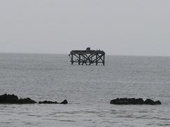
Garlieston was absolutely lovely, and I can only wish that I had seen it in better weather. I was quite fed up as I approached he town, but one sight of Sam cheered me up no end. We sat in Mervan to get out of the rain and so that I could eat my sandwiches. Sam had arranged an interview with a local station, and I managed to get through this despite the fact that I was not quite with it. Sam had noticed hat one of the pubs in he town had an exhibition on about Mulberry Harbours, which were tested in Cruggleton Bay. I have been seeing references to Mulberry Harbours all the way up the south and west coasts, from a sunken section near Dungeness to yards where parts were built in a Devon estuary. In Cruggleton Bay there is a Mulberry Dolphin that sunk during the tests (a dolphin is a structure used to moor boats which are waiting to enter a harbour). Although I have seen many references to these harbours around the coast I have not seen many photographs of them, and the exhibition opened my eyes to how complex these structures were. It really was an amazing feat to get two harbours across the channel and to the beaches so quickly after D-Day, and a superb detailed model of one of the harbours bought the feat to life.
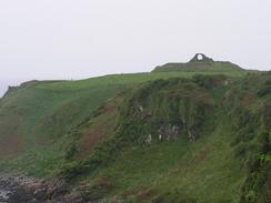
The wet weather this afternoon got me down, and turned the walk into one long trudge. I had been planning to walk along the coast south from Cruggleton Castle, but due to my experiences earlier in the day and the highly non-optimal weather I decided to divert down to the road and to walk down to Isle of Whithorn along that. On my way down to the road I passed Cruggleton Old Church. This is quite a curious church, as it is in its own wooded glade in the middle of a field about fifty yards from the road. There were no obvious gravestones around the church, and the ornate doors were locked so I could not enter. The church is very near to the castle, so I wonder if the church was originally associated with it (the castle itself is a very unremarkable ruin, consisting of little more than an ach of stones held in position with curved bars).
It was with some relief that I eventually reached Mervan in the Isle of Whithorn, and I could get my wet coat and overtrousers off. I am getting more than a little fed up with wet weather, and I would like to have a dry day for a change. Unfortunately the weather forecast is for wet weather up to and through the weekend, so I am afraid that I am going to have to resign myself to getting wet. On a more positive note, tomorrow I am changing from heading from a southerly course to a northwesterly course, as I head towards Stranraer.
Directions
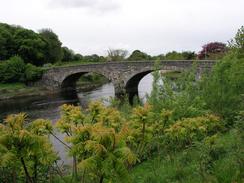
This walk starts off in the market square in the town of Wigtown. Head to the western end of the square and pass a co-op, before turning to the left down the A714 road that heads southwestwards into Bladnoch. In Bladnoch the road joins another road and turns sharply to the left to cross the Bladnoch River on an attractive bridge. On the southern side of the bridge turn left to walk eastwards along the southern bank of the river along a minor road. This road heads under the arch of an old railway bridge, before turning to the right to head past Blandon Mains on the right and an old airfield on the left. When this road ends at a T-junction turn to the right to head westwards for a few hundred yards until the road ends at a T-junction with the A714 road.
Turn to the left to head southwards along the A746 road, which at the junction with the B7085 road becomes the A746. Follow the A746 through the villages of Braehead and Kirkinner. When a junction with the B7004 is reached continue southeastwards along this road for two and a half miles until a road leads off to the left. This road heads northeastwards for a little over a mile, passing to the south of the farm at Culscadden before reaching Innerwell Fishery. The road starts to descend downhill curving sharply to the right, and at the point where this bend changes to a left-hand curve, a track leads off to the right past a small building.
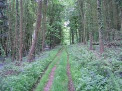
The track is initially quite distinct, but it soon becomes less distinct as it heads through the woodland past Juttock Point and Port McGean. When it approaches Eggerness do not go through the private garden but continue on through the woodland until a gate is reached that leads into a field. Keep the woodland on the left as you walk along the edge of the field, and eventually keep a northwesterly course as you make your way to a road (I personally could not find the track marked on the map, so I had to make my own route). Eventually a road is met, and this can be followed all the way around Garlieston Bay into Garlieston.
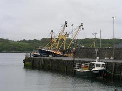
From Garlieston continue along the road past a large industrial building and towards the quay. From here a distinct and good path continues on southwards beside the coast through the grounds of Galloway House, where the path curves around the attractive Cruggleton Bay. Eventually Sliddery Point is reached, and here the path heads south for a little over a kilometre until Cruggleton Point is reached, and the ruins of Cruggleton Castle. At the castle turn to the right to head westwards over the brow of a hill (there are some gates to allow you through the fences) and down pas Cruggleton Old Church to meet the B7063 road. Turn left to walk southwards along the B7063 road for about four and a half miles into the Isle of Whithorn. This walk ends at a car park by the B7063 / B7004 junction in the village.
Distances
| From | To | Distance (m) | Ascent (ft) | Descent (ft) |
|---|---|---|---|---|
| Wigtown | Garlieston | 12.3 | 636 | 755 |
| Garlieston | Isle of Whithorn | 8.0 | 433 | 433 |
This makes a total distance of 20.3 miles, with 1069 feet of ascent and 1188 feet of descent.
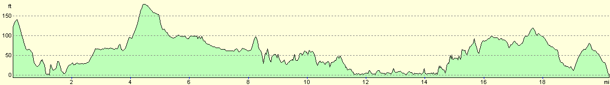
For more information on profiles, ascents and descents, see this page
Accommodation
We parked Mervan in a car park just off the B7063 / B7004 road junction in the Isle of Whithorn. This was quite convenient for all the local facilities, and there were some public toilets nearby.
Disclaimer
Please note that I take no responsibility for anything that may happen when following these directions. If you intend to follow this route, then please use the relevant maps and check the route out before you go out. As always when walking, use common sense and you should be fine.
If you find any information on any of these routes that is inaccurate, or you wish to add anything, then please email me.
All images on this site are © of the author. Any reproduction, retransmissions, or republication of all or part of any document found on this site is expressly prohibited, unless the author has explicitly granted its prior written consent to so reproduce, retransmit, or republish the material. All other rights reserved.
Although this site includes links providing convenient direct access to other Internet sites, I do not endorse, approve, certify or make warranties or representations as to the accuracy of the information on these sites.
And finally, enjoy your walking!
This walk was mentioned in the following routes:
| My walk around the coastline of Britain |
Nearby walks
| # | Title | Walk length (miles) |
|---|---|---|
| 447 | Kirkcudbright to Skyreburn | 19.1 |
| 448 | Skyreburn to Wigtown | 23.5 |
|
|

|