Walk #447: Kirkcudbright to Skyreburn
 |
 |
|
General Data
| Date Walked | 19/05/2003 |
| County | Dumfries and Galloway |
| Start Location | Kirkcudbright |
| End Location | Skyreburn |
| Start time | 10.47 |
| End time | 17.58 |
| Distance | 19.1 miles |
| Description | This was a highly enjoyable walk, with some nice road and cliff top walking on route. There are also some lovely buildings, both ruinous and in use. |
| Pack | For the first six and a half miles of the day I wore a bumbag, but for the rest of the day I carried my 30-litre Karrimor HotRock rucksack, which was filled with my packed lunch, waterproof leggings, water bottle and a couple of spare shirts, together with the usual assortment of odds and ends. |
| Condition | I feel absolutely fine after this walk, and have no significant problems to report. My right shoulder gave me no problems, and both of my feet and ankles did not hurt or ache. It is a relief to have a day with no problems, as the last few have been troublesome. |
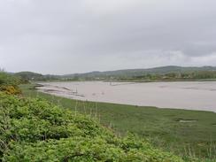
| Weather | Yet again the day was one of sunshine and showers, which was slightly annoying. The morning was mostly dry, which allowed me to do the first six and a half miles in trainers, but the afternoon had some very heavy showers, one of which was the heaviest shower that I can remember having on this walk. The rain just bucketed down, big raindrops hitting the hood of my coat in such a way that I could feel each individual raindrop. Fortunately after about half an hour the rain stopped, and although there were other showers none were as heavy - or as long - as that one. |
| OS map | Landranger number 83 (Newton Stewart & Kirkcudbright, Gatehouse of Fleet) |
 |
 |
|
 |
 |
|
Map of the walk
Maps courtesy of Google Maps. Route for indicative purposes only, and may have been plotted after the walk. Please let me have comments on what you think of this new format. For a detailed table of timings for this walk, please see the table file.
 |
Notes
Mum and dad dropped me off at the tourist information in Kirkcudbright so that I could start the walk. I had a quick look around the centre of the town, which is a superb little place. Eventually I set off, walking down the quayside and then crossing the river on the bridge. The first six miles were going to be along a road, and so I was wearing my trainers to reduce the strain of the long road sections on my feet. I managed to average three and a half miles an hour for the six and a half miles back to the caravan site, and I therefore found myself back at the site earlier than I had expected. My parents had decided leave today, and I sat and chatted to them as I had a coffee. It had been great to see them, and it was a shame to see them go. I used the opportunity to change into my boots, as the next section of path was going to be rough.
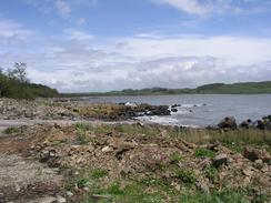
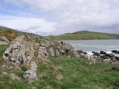
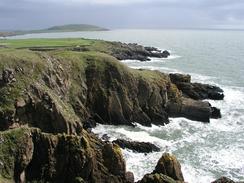
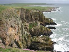
The caravan site have made a path through the woods around the site and the adjacent golf course, and this gave me a good path to follow through the woodland, which was alive with red and blues from bluebells and red campion, a marvellous carpet of wildflowers that contrasted well with the greens and browns of the woodland. After the golf course I made my own way along the shoreline and cliff tops towards kirkandrews; this was not a very hard walk even though there was no path, and I enjoyed the views, which were lovely. About halfway along I met a local farmer who I chatted to for a few minutes about the local area - hey are always great sources of information and little titbits of knowledge.
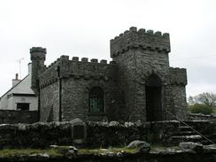
The church at Kirkadrews is absolutely superb, and looks like no other church that I have seen on the trip. It is quite small and rectangular in plan, but the lintel on the outside of it is castellated, a turret disguises the chimney and at first glance you would not believe that it was a church. The architect is believed to be G.H. Higginbottom of Manchester, who designed several similar buildings. The atmosphere inside the church was lovely, and I had a quick look around as I tried to hide from a heavy shower. A little distance to the west at Gorseyard there was another imposing rectangular tower in a farmyard, and farm buildings surrounded this. Amazingly, however, the walls of the adjacent barn had been give the same styling as the tower, which to some extent allowed the barn to blend in more with the much taller tower.
From Kirkandrews I followed roads and tracks northwards all the way until I hit the A75(T). During much of this stretch it was raining, which prevented me from taking many photographs or admiring the views too much. As I approached the A&5(T), which is on the south side of Gatehouse of Fleet, I received a phone call from Sam, who told me that she was a mile west of the town in a lay-by. This suited me quite well, as I had to walk along the A75(T) anyway, so we agreed to meet there.
It would be very easy to say that today was ruined by the rain, but generally it did not bother me that much. It was quite a warm day and there was not much wind, so even though my coat and over trousers were soaked I did not get cold. Before I set off on this trip I had a saying, 'the fear of rain is worse than the experience of being out in the rain', and today was a classic example of this. In some ways the rain was quite invigorating, and although I would no say that I enjoyed the rain it was not exactly a bad experience. If it had been windy I would undoubtedly have felt worse, but fortunately this was not the case.
Tomorrow I have a long road walk to make, along the A75(T) all the way to Newton Stewart. I hope that it is not raining, and that I will be able to wear trainers along this long road walk. Hopefully the road will not be too busty - certainly the mile that I did along it tonight was not too bad, even in the rain, and there was a nice tarmac strip that I could walk along beside the road.
Directions
This walk starts off in the car park by the tourist information office in Kirkcubright. Walk past the tourist information to the quayside, and then turn right to walk along the quay to the road bridge. Turn left and head westwards along the A755 road until the junction with the B727 road is reached after about half an hour. Turn left down the B727, and follow this road southwestward into Lower Nunton. Here the road leaves the coast and head inland, and after another couple of miles the junction with a road is met on the left. Turn left down this road, and follow it for a couple of miles, passing the entrance to Sewick House. At another junction follow the road as it turns to the right, and follow the road as it passes Brighouse, and eventually a car park is reached on the left by Brighouse Bay.
Go through the car park and take a path that continues on at the end. This path lead through an attractive wooded area between the caravan park and Brighouse Bay, and once the woodland ends it continues on past a golf course, turning to head westwards at Dunrod Point until the end of the golf course is reached near Borness Batteries. When the path turns to the right to climb over a ladder stile continue straight on along the cliff top, keeping the stone wall to your right. The cliffs go up and down as it slowly curves around to head northwards, and I had to climb over a couple of barbed wire fences before I finally met the end of a track at Kirkandrews.
Turn left to head northwards along the track, which soon become a road and passes the curious little church at Kirkandrews. Soon after this the road ends at a T-junction; turn left and follow this road westwards past the tower at Corseyard and onwards as it turns to head northwards. Shortly after Knockbrex a road lads off to the left; take this road and follow it northwards as it becomes a track and lads on to a little complex of holiday chalets at Carrick. Follow the track as it swings to the left and then the right, resuming a northerly course until it joins a road at a bend. Turn left to head northwestwards along this road for about half a kilometre, until it ends at a phone box by the entrance to a caravan park at Sandgreen.
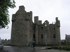
Turn right and head northwards along the track through the caravan site. When the caravan site ends follow a track that heads through an avenue of trees northeastwards, and when it enters a deer park continue on along the track, and on past Cally Mains. As it heads through Laundry Wood the track becomes surfaced, and heads under the A75(T). On the other northern, side of the bridge turn to the left and follow a track westwards beside the A75(T). Whenever seems convenient, climb the fence and go up the embankment to join the A75(T). Walk along the road northwestwards, passing over the Water of Fleet and the ruins of Cardoness Castle. This walk ends in a lay-by on the A75(T) near Skyreburn, about a miles southwest of the A75(T) / B796 junction.
Distances
| From | To | Distance (m) | Ascent (ft) | Descent (ft) |
|---|---|---|---|---|
| Kirkcudbright | Brighouse Bay | 6.0 | 407 | 381 |
| Brighouse Bay | Kirkandrews | 5.1 | 610 | 591 |
| Kirkandrews | Skyreburn | 8.0 | 551 | 548 |
This makes a total distance of 19.1 miles, with 1568 feet of ascent and 1520 feet of descent.
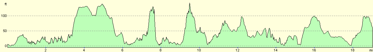
For more information on profiles, ascents and descents, see this page
Accommodation
We parked Mervan in a lay-by beside the A75(T) at Skyreburn, a mile to the west of the B796 junction. This was not too noisy a place to spend the night, and although there were no facilities we did not need any.
Disclaimer
Please note that I take no responsibility for anything that may happen when following these directions. If you intend to follow this route, then please use the relevant maps and check the route out before you go out. As always when walking, use common sense and you should be fine.
If you find any information on any of these routes that is inaccurate, or you wish to add anything, then please email me.
All images on this site are © of the author. Any reproduction, retransmissions, or republication of all or part of any document found on this site is expressly prohibited, unless the author has explicitly granted its prior written consent to so reproduce, retransmit, or republish the material. All other rights reserved.
Although this site includes links providing convenient direct access to other Internet sites, I do not endorse, approve, certify or make warranties or representations as to the accuracy of the information on these sites.
And finally, enjoy your walking!
This walk was mentioned in the following routes:
| My walk around the coastline of Britain |
Nearby walks
| # | Title | Walk length (miles) |
|---|---|---|
| 446 | Palnackie to Kirkcudbright | 23.4 |
| 448 | Skyreburn to Wigtown | 23.5 |
|
|

|