Walk #448: Skyreburn to Wigtown
 |
 |
|
General Data
| Date Walked | 20/05/2003 |
| County | Dumfries and Galloway |
| Start Location | Skyreburn |
| End Location | Wigtown |
| Start time | 08.34 |
| End time | 16.46 |
| Distance | 23.5 miles |
| Description | his was a very long and boring road walk, with only a few high point to be had on route. Despite this I am glad that I did it, and I have ended the day feeling better than I did when I started it. |
| Pack | Today I carried my 30-litre Karrimor HotRock rucksack, which was filled with my packed lunch, waterproof leggings, water bottle and a couple of spare shirts, together with the usual assortment of odds and ends. |
| Condition | Although I am slightly fatigued after this long walk, I have not suffered any significant problems. Both of my ankles are fine, as is my right shoulder, which I am thankful for. |
| Weather | Today was not a bad day, with some sunshine but a long and heavy rainstorm for an hour at lunchtime. The slight breeze helped to dry me out, as did the late afternoon sunshine. |
| OS map | Landranger number 83 (Newton Stewart & Kirkcudbright, Gatehouse of Fleet) |
 |
 |
|
 |
 |
|
Map of the walk
Maps courtesy of Google Maps. Route for indicative purposes only, and may have been plotted after the walk. Please let me have comments on what you think of this new format. For a detailed table of timings for this walk, please see the table file.
Notes
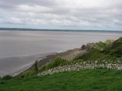
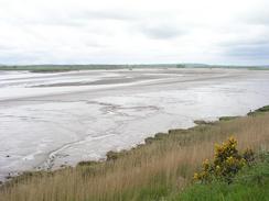
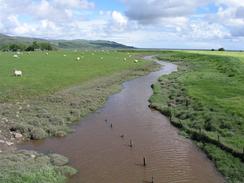
Today was a day of radically differing emotions for me. The long, boring section along the A75, with a multitudinous horde of lorries passing me, was extremely boring and quite depressing, although there were some views to be had out to sea or along the estuary on occasion. I plodded the miles out quite fast, unencumbered by any difficult terrain, but also because I just wanted this stretch to finish and to get to somewhere ore scenic. The only highlight of this stretch was Carsluith Castle, a lovely rectangular tower house, and I spent a few minutes looking around this and climbing up the spiral staircase to the viewing platform. I have passed several tower houses in the last few days, and they really are lovely structures. It would be nice to be able to see one that is complete (i.e. has all the intermediate floors in and a roof), but I do not know if any exist.
One slightly funny event happened on this long trudge - an old Fergie tractor pulling a little trailer passed me, and on the back of the trailer was a banner with 'World endurance tractor challenge' written on it. A hundred yards behind was another, more modern, tractor pulling a caravan. It was an unusual sight, and I will have to a web search for it when I get time.
I had already walked quiet a way by the time that I reached Newton Stewart, and I had not yet stopped for lunch. I did not fancy diverting into the town to find a pub, and it was raining so I did not want to sit down, so I kept plodding on, expecting my first stop to be when I reached the end of the walk in Wigtown. On the way down the A714, however, I passed signs for a pub called the Black Sheep Inn, and as this was open I nipped in so that I could have a rest. The traffic on the A714 was much busier than it normally would be, as the A75 was shut to the west of Newton Stewart and the diversion route was down the A714. Fortunately I did not need to walk along the road for long,and I diverted down a quiet local road to reach Wigtown. Notes from 2019: keep an eye out for an eerie statue in the woods on the right-hand side of the road near Carsenestock.
I was still feeling quite low, and so I started singing as I walked along. At one point there were a few cows with their heads sticking over a fence, and I stopped, turned to face them and started to serenade them with a couple of verses. I cannot have been singing that badly, as they just continued to look at me. A little further on I met a man who was out walking two dogs, and I chatted to him for a few minutes before moving on. Sam had walked down from Wigtown to meet me, and as we passed the Martyr's Stake on the eastern edge of the town we met the gentleman once again, and he offered us a free night in one of his holiday cottages. This was exceedingly kind of him, and we readily agreed. This is the sort of kindness that has come to be the best feature of this walk, and it was a great way to end a day on which I had been quite depressed.
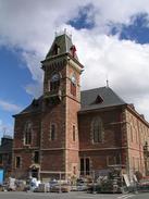
I was very impressed with Wigtown. The town is known as the Scottish equivalent of Hay-on-Wye, the book capital of Scotland, and this is quite accurate. Being a bit of a bibliophile, I went into a bookshop and bought two books that I can read during the trip - the first volume of Winston Churchill's 'The Second World War', and an excellent book called 'The Naval Side of British History' by Callender. I could have easily bought at least ten books from one shop alone, and I had to control myself so that I did not. I also had a quick look around the exterior of the church in the town - this is quite modern (it opened in May 1853), and replaces an older church, the ruins of which are beside the new church - and at the graves of the Wigtown Martyrs. These were two women who were found guilty of Covenanting crimes on the 11th of May 1685, and were drowned in the river below the church. There is a memorial to them below the church, and their graves are beside the ruins of the old church.
It feels very strange to have space around us - after spending eight months in a motorhome, spending the night in a place with more than one room is a strange experience. This is my fourth night on the entire trip that I have spent not in Mervan, and in all the others I had access to only one room, so having this cottage is amazing. Jut being able to walk from the kitchen into the bedroom is a curious, spacious experience, and to be able to lie down on the floor with all limbs spread-eagled is luxury. The offer of this flat was such a kind and generous offer, and one that is very gratefully received. Sam has taken to it like a duck to water, but I am suffering a strange sort of agoraphobia from not having the ceiling a few inches from my head whilst I am in bed.
Directions
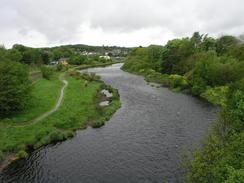
This walk starts off on a lay-by on the A75(T), a mile to the southwest of the b796 junction in Skyreburn. The directions for the first thirteen and a half miles are very simple - just follow the A75(T) road as it roughly follows the coast. The road was not too busy, and there were wide verges in most places, so I did not feel like it was too dangerous. The road passes the ruins of Carsluith Castle and the villages of Carsluith and Creetown, until it approaches Newtown Stewart. Near Blackgraig turn to the left down a road that heads towards the bank of the River Cree at Parkmaclurg, before turning to the right to head northwestwards for a little over a mile until it ends at the A75(T).
Turn left and follow the A75(T) westwards for nearly a mile, crossing the River Cree, until a roundabout with the A714 road is reached. Turn left to head south along the A714 road for a mile and a half (for the first kilometre of this road there is a pavement, for the rest there is not) until a road junction is met on the left near Lamachan View and St Ninian's Well. This minor road is signposted for 'Carty Port' and 'Moss of Cree'. Turn left and follow this minor road through Carty Port and then south to Grange of Cree, before it turns to head southwest to Borrowmoss. The road then climbs over an old rail bridge and joins another road, which heads southwards before turning to the right and climbing uphill past the church into the centre of Wigtown, where this walk ends.
Notes: September 2019. The walk south along the A714 can now mostly be avoided; this alternative is a little longer, but avoids a nasty little stretch of pavementless road walking. When you reach the A75(T)/A714 roundabout to the south of Newton Stewart, turn right up Wigtown Road. Take the second road off to the right, and follow it as it heads downhill and swings to the left towards a little industrial area. The road soon swings to the right and then left; shortly after the bend, turn right along a small path that leads to a riverside cyclepath. Turn righ to head south, with the river on the left. The cyclepath soon passes under the A75(T) road bridge, and then swings around before climbing to parallel the A714 road on the right. It eventually joins the road, and a good, wide cyclepath continues on to reach the road junction by Lamachan View and St Ninian's Well.
Distances
| From | To | Distance (m) | Ascent (ft) | Descent (ft) |
|---|---|---|---|---|
| Skyreburn | Newton Stewart | 16.1 | 965 | 961 |
| Newton Stewart | Wigtown | 7.4 | 312 | 249 |
This makes a total distance of 23.5 miles, with 1277 feet of ascent and 1210 feet of descent.
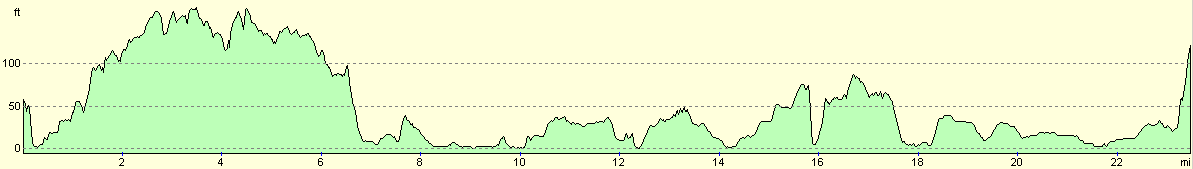
For more information on profiles, ascents and descents, see this page
Accommodation
We spent the night in one of the Borrowmoss Cotages, self-catering accommodation that is a short distance to the north of the town. The cottage that we stayed in was excellent, very roomy and warm. The cottages have been converted out of old farm byres, and have two bedrooms. I can thoroughly recommend this accommodation, and the owners (Roy and Margaret Surplice) can be contacted on (01988) 402436 or at www.borrowmoss.com.
Disclaimer
Please note that I take no responsibility for anything that may happen when following these directions. If you intend to follow this route, then please use the relevant maps and check the route out before you go out. As always when walking, use common sense and you should be fine.
If you find any information on any of these routes that is inaccurate, or you wish to add anything, then please email me.
All images on this site are © of the author. Any reproduction, retransmissions, or republication of all or part of any document found on this site is expressly prohibited, unless the author has explicitly granted its prior written consent to so reproduce, retransmit, or republish the material. All other rights reserved.
Although this site includes links providing convenient direct access to other Internet sites, I do not endorse, approve, certify or make warranties or representations as to the accuracy of the information on these sites.
And finally, enjoy your walking!
This walk was mentioned in the following routes:
| My walk around the coastline of Britain |
Nearby walks
| # | Title | Walk length (miles) |
|---|---|---|
| 447 | Kirkcudbright to Skyreburn | 19.1 |
|
|

|