Walk #450: Isle of Whithorn to Auchenmalg
 |
 |
|
General Data
| Date Walked | 22/05/2003 |
| County | Dumfries and Galloway |
| Start Location | Isle of Whithorn |
| End Location | Auchenmaig |
| Start time | 09.10 |
| End time | 17.42 |
| Distance | 22.1 miles |
| Description | This was quite a long walk, the first half of which was along footpaths along cliffs and beaches, and the second half along fortunately quiet roads. |
| Pack | Today I carried my 30-litre Karrimor HotRock rucksack, which was filled with my packed lunch, waterproof leggings, water bottle and a couple of spare shirts, together with the usual assortment of odds and ends. |
| Condition | I feel absolutely fine after this walk, although I am quite fatigued. Yet again both of my ankles and my right shoulder were okay, which I am glad about. |
| Weather | This was the first dry day for some time, with no rain of any kind during the day. The sun even came out for a it this afternoon, but aside from this there were some heavy clouds overhead. There was also quite a breeze coming off the sea whilst I was on the high cliffs, and this was slightly troublesome when it gusted. |
| OS map | Landranger number 83 (Newton Stewart & Kirkcudbright, Gatehouse of Fleet) and Landranger number 82 (Stranraer & Glenluce, The Rhins) |
 |
 |
|
 |
 |
|
Map of the walk
Maps courtesy of Google Maps. Route for indicative purposes only, and may have been plotted after the walk. Please let me have comments on what you think of this new format. For a detailed table of timings for this walk, please see the table file.
 |
 |
|
 |
Notes
Before I set off on the walk today I went for a little walk around so that I could have a little look around the village of Isle of Whithorn. The village is absolutely lovely and I enjoyed looking around the harbour, but my main target was to find the ruins of St Ninian's Chapel. This was hidden behind a little hillock, and the views from the site out to sea in all directions were quite fantastic. I had to tear myself away so that I could walk back to Mervan to start the walk proper.
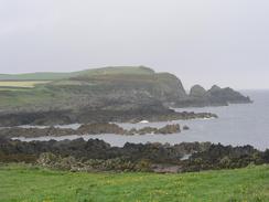
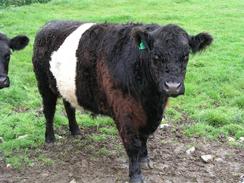
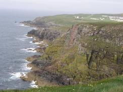
The cliffs heading southwest to Burrow Head were lovely, and the view from the top out to sea were great. I really enjoyed the walk, despite the fact that I passed signs forbidding entry on the track leading towards the farm at Morrach. I walked through a couple of fields with bulls in them, but they were some distance away and seemed to be more interested in the cows than in me. At Burrow Head there is a caravan park, and the path northwestwards to St Ninian's Cave was very distinct on the ground as it is an official path. Again the cliffs were lovely, and the views from the top fantastic. Apparently you should be able to see England and the Isle of Man from here, but there was too much haze and cloud in the sky to be able to see them today.
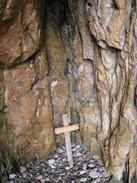
St Ninian's cave was rather unimpressive, little more than crack in the cliff face, but I daresay that is why a saint would like to spend time there. The views out from the cave were nice, and I enjoyed looking around the cave at all the crosses that people had left in the cave. The cave is famous for carved stone crosses that had been left inside, and whilst these are now in museums some nice wooden ones have been left in their place. There were even some pebbles that people had scratched crosses into lodged into crevices in the cave, and the cave had a lovely ambience.
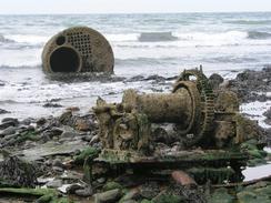
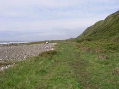
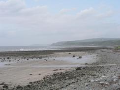
As the tide was low I decided to walk northwestwards along the shingle beach instead of heading inland to the road, which would have been a big diversion. There is an initial headland to get around which would be impassable at high tide, but I managed to get around this. A few hundred yards further on I saw a cylindrical object at the edge of the water, and as I got closer to it I could see that it was a small boiler. Other wreckage also became visible, including some winch gear and a hatchway, and I found myself walking over hull plating. The metalwork had obviously been there for some time, but much was still recognisable. I wondered about the history of the ship - as it had at least one boiler and the hull plates were riveted it was obviously not a modern ship, but I had no other way of telling what era it was from. After a few minutes investigating the wreck I proceeded on, although I found the shingle - which varied in size from small boulders to small pebbles - increasingly hard to walk on. Fortunately near Hill of Glasserton a wide foreshore became available. This is actually a raised beach, and although this made the walking easier in places, in others it was very overgrown and I had to walk along the shingle again.
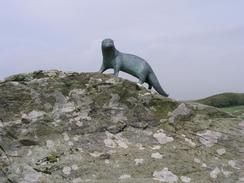
The northwestern end of the beach was blocked by the tide, so I climbed up onto the cliffs and made my way to the bronze otter that is the memorial to Gavin Maxwell, the author and naturalist who wrote 'Ring of Bright Water'. He was born and raised in Monreith, and his family owned the Monreith Estate. The A747 road immediately to the west of Monreith was shut as the road was slipping down the cliff, but I was able to walk through despite this. There then followed a long road slog to Port William, where I met Sam and ate my sandwiches.
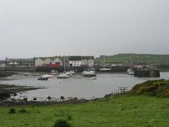
The rest of the walk was a long road slog along the A747, which normally would have been quite a boring walk. Fortunately, however, I took a novel with me and as I walked along I read this. The traffic on the road was very light, and so I could get away with this safely as long as I took care. The fact that I was reading made the time fly by, and I soon found myself arriving at the campsite where we were spending the night. Later on in the evening we went out to the pub that is adjacent to the caravan park, the Cock Inn, for a quick drink. I had one pint and then left as I was exceedingly tired, but Sam stayed for a fair while longer and eventually got back after eleven, seemingly having enjoyed herself.
Directions
This walk starts off at the car park by the public toilets in Isle of Whithorn, beside the B7063 and B7004 road junction. Walk out of the village westwards along the B7004 road, passing the post office, and then turn left uphill along a road past some houses. Just after a right-hand bend turn to the left down a track, which heads southeastwards past a cottage, before turning to the right to head southwestwards, eventually reaching the farm at Morrach. (Note that the stretch of track towards Morrach had a private and no entry sign, which I studiously ignored).
When the track turns sharply to the right at Morrach Farm turn to the left down a rugged track which leads through a gate and heads towards the cliff top. Once at the cliff top turn right and follow the cliffs southwestwards towards Burrow Head. Although there is no path the going is quite easy, and you can choose either to walk in the fields or in a narrow band of land between the edge of the cliffs and the field wall. When Burrow Head is reached continue along the cliff top northwestwards, entering a caravan site, and on through that along a surfaced track. From the northwestern end of the caravan site there is a marked path as far as Port Castle Bay, and the going is again easy.
Just before Port Castle Bay is reached the path starts to descend downhill to meet the eastern end of the bay. Walk along the shingle northwestwards until you reach a small cave in the cliff-face; this is St Ninian's Cave. What you do next is very dependant on the tide; if the tide is low, then progress past the headland at the northwestern end of the bay (this involves scrambling over slippery rocks), and then start heading northwestwards along the foreshore. If the tide is high then you will have to find an inland route. Progress along the foreshore is difficult in places, as the going underfoot is quite tough, but eventually you reach the Point of Cairndoon. From here it was obvious that further progress along the foreshore would be difficult, so climb up onto the cliff top and follow the edge of the cliffs northwestwards, passing the golf course at the Point of Lag until you reach the access road to the golf course by the memorial to Gavin Maxwell. A path leads from here to the A747 main road in Monreith.
Turn left and follow the A747 through Monreith and on along the coast, passing Barsalloch Fort and eventually reaching Port William after two miles. Follow the toad past the harbour and when a roundabout is reached in the town turn left and follow the A747 road northwestwards for nearly nine miles, until the Cock inn is reached in Auchenmaig. This walk ends at the caravan site adjacent to the Cock Inn.
Distances
| From | To | Distance (m) | Ascent (ft) | Descent (ft) |
|---|---|---|---|---|
| Isle of Whithorn | Port William | 13.4 | 1532 | 1526 |
| Port William | Auchenmaig | 8.7 | 577 | 554 |
This makes a total distance of 22.1 miles, with 2109 feet of ascent and 2080 feet of descent.
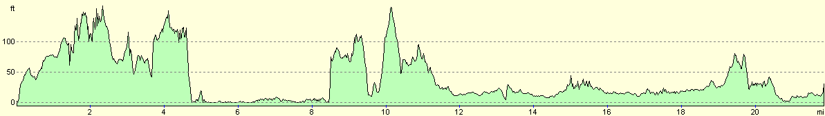
For more information on profiles, ascents and descents, see this page
Accommodation
We stayed at the Luce Bay Holiday Park, Auchenmaig, Newton Stewart, Wigtownshire, Dumfries and Galloway DG8 0JT. This site cost us nine pounds for the night, which was quite reasonable, and they can be contacted on (01581) 500227.
Disclaimer
Please note that I take no responsibility for anything that may happen when following these directions. If you intend to follow this route, then please use the relevant maps and check the route out before you go out. As always when walking, use common sense and you should be fine.
If you find any information on any of these routes that is inaccurate, or you wish to add anything, then please email me.
All images on this site are © of the author. Any reproduction, retransmissions, or republication of all or part of any document found on this site is expressly prohibited, unless the author has explicitly granted its prior written consent to so reproduce, retransmit, or republish the material. All other rights reserved.
Although this site includes links providing convenient direct access to other Internet sites, I do not endorse, approve, certify or make warranties or representations as to the accuracy of the information on these sites.
And finally, enjoy your walking!
This walk was mentioned in the following routes:
| My walk around the coastline of Britain |
Nearby walks
| # | Title | Walk length (miles) |
|---|---|---|
| 449 | Wigtown to Isle of Whithorn | 20.3 |
|
|

|