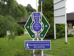
Walk #909: West Highland Way: Kingshouse to Fort William
 |
 |
|
General Data
| Date Walked | 04/07/2011 |
| County | Highlands |
| Start Location | Kingshouse Hotel |
| End Location | Fort William (end of WHW) |
| Start time | 08.40 |
| End time | 20.20 |
| Distance | 24.8 miles |
| Description | This was a stunning walk through some superb Highlands scenery; a steep climb up the Devil's staircase unveils the Mamors to the north, before a long plod takes you down into Kinlochleven. It is easy to stop in the village for the day, but more effort takes you up the hillside and into the Lairig, with high hills surrounding you. Finally a slow and steady descent leads down into Glen Nevis, which can be followed to the end of the West Highland Way in Fort William. |
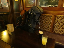
| Pack | Today I carried my Macpac Glissade rucksack containing my North Face Westwind tent, spare clothes, waterproofs, water, and enough food to last three days. In total it weighed about thirty-five pounds. |
| Condition | I am very tired after this walk and my left ankle felt slightly weak during the day after yesterday's twist, but otherwise I am fine. |
| Weather | Today started off sunny with some scattered cloud, and remained this way for much of the day. It started to become overcast as the evening frew on, but there was never any threat of any rain. |
| OS map | Landranger number 41 (Ben Nevis, Fort William & Glen Coe) |
 |
 |
|
Map of the walk
Maps courtesy of Google Maps. Route for indicative purposes only, and may have been plotted after the walk. Please let me have comments on what you think of this new format. For a detailed table of timings for this walk, please see the table file.
 |
 |
|
Notes
I awoke early this morning and got my tent out from the hotels drying room and packed my rucksack. It was going to be a farcically short day with only about nine miles (but also a steep climb) to get to Kinlochleven. It therefore seemed sensible to have a cooked breakfast at the hotel, which proved to be both substantial and tasty. I therefore only set off on the days walk at about twenty to nine, far later than I ordinarily would have done, something that would have an effect later in the day.
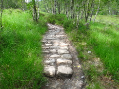
The initial part of the trail headed over the river before following the old road back towards the main road. All too soon it diverted off, becoming a path that climbed uphill. It was the sort of climb I like - shallow enough for me to power up without losing my breath. A German approached from behind and we chatted for a few minutes - this was his first trail and he was walking as far as Kinlochleven today, a walk that he was looking forward to. After about five minutes my left foot (which I twisted slightly yesterday) started to twinge and I dropped behind as he powered ahead.
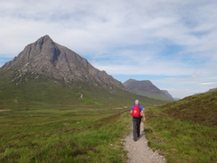
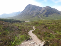
Soon afterwards I passed an attractive young American lady sitting at the side of the path; we exchanged pleasantries and I left her behind to reach the base of the Devils Staircase. This is widely acknowledged as being an evil climb of about 250 metres into a belach between two hills; it was widely used by the Navvies who built the Blackwater Reservoir in the 1900s. I remembered it as being fairly easy from my previous walk, and so it proved. It was a highly enjoyable climb with the hills to the south of Glen Coe unfolding with every step. A series of zigzags meant that the gradient was never too steep and that I could keep up a good pace with only occasional pauses to admire the view.
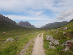
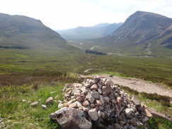
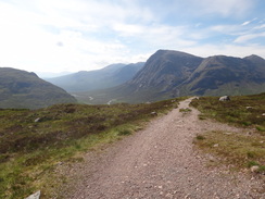
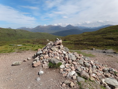
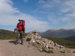
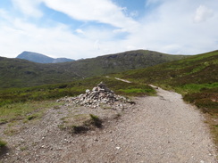
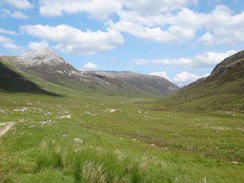
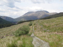
The views from the cairn that marks the top of the climb were superb; the hills of Glen Coe lay behind with those of the Mamores ahead; the summit of Ben Nevis poked guiltily above the lesser hills. I drunk in the views as the lady I had met earlier came along; she took a photograph of me by the cairn and we walked together for a while. The German man I had talked to earlier was already a tiny spot in the distance and I wondered why he was walking so fast; it was a day for ambling along and drinking in the views.
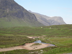
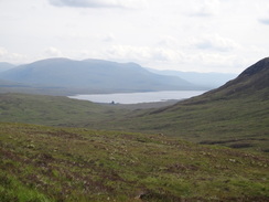
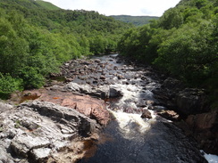
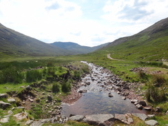
A descent took us down and up the other side of a little valley, with some good views of Blackwater Reservoir glinting in the sunshine off to the right. I left the American lady at this second summit and started on the long descent down to Kinlochleven. Whilst I had fond memories of the climb up the Devils Staircase, those of the descent were far from pleasant. My recollections were correct and there was little to commend the long walk, especially when the path got lower. I passed an American couple who were bathing by the bridge over the Allt a Choire Odhair-mhoir; they had set off from Kings House shortly after seven and had been taking a very easy walk - understandably as the day to Kinlochleven is so short.
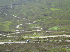
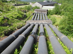
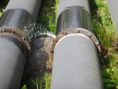
The trail left the rough paths behind and joined a track that started to wind down the wooded hillside. My left ankle still ached but I sped up along the almost unfeasibly steep tracks, built to provide access for maintenance of the massive pipes that provide water from Blackwater Reservoir to the hydroelectric power station in the valley below. It was a long and boring walk with little to commend it, and it was a relief when I finally started to approach the village. The path passed over the six massive black pipes on a bridge, and I was surprised to see a fountain of water erupting from a flange in a pipe - the pressure inside must be fantastic.
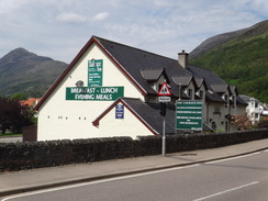
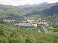
I reached Kinlochleven just before one and I had to think about what to do. My initial plan had been to walk on and camp somewhere in the hills between Kinlochleven and Fort William, but my twisted ankle of yesterday had made me consider camping at Kinlochleven instead, giving me an easier day. However I was still feeling fresh and my ankle was not hurting too much, so I retired to the pub to consider my options. I ordered some fish and chips and as I ate I chatted to a couple of motorcyclists who were touring the Highlands. Their holiday was certainly a great deal more relacing then mine!
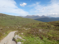
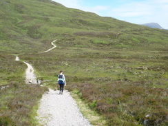
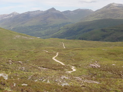
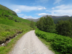
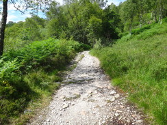
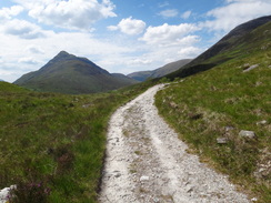
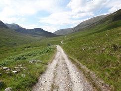
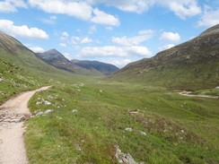
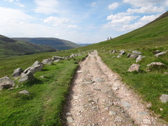
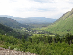
After filling up my water bottle I set off out of the village. A long and steep climb through trees - in my opinion steeper than that of the Devils Staircase and without the advantage of expansive views - took me up onto the southern flank of the Mamore Hills. Relief came when it met a track that contours westwards through a valley called the Lairig, separating Beinn na Caillich and Mam na Gualainn to the south from the main Mamore range to the north.
The track made for easy going and I was soon passing the ruined farmstead at Tigh-na-sluebhaich, which whilst roofless still had mostly complete walls. Shortly afterwards I went over slightly on my left ankle once more, showing that it had still not recovered fully from yesterdays twist.
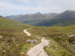
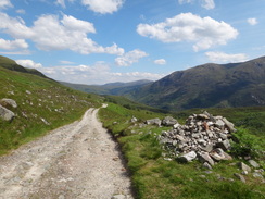
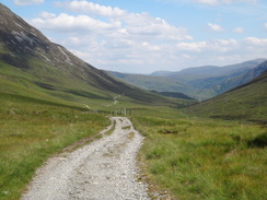
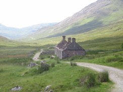
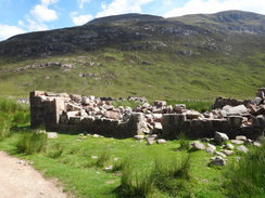
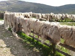
The farm at Lairigmor was little more than a shapeless collection of stone bocks, with few walls remaining above head height. After this the path turned to the right, still contouring along the hillside to head north with the Allt na Lairig Moire down to the left. The views started to unfold once more as I headed towards an area of woodland marked on the map. After passing through a sheepfold that had recently-sheered fleeces hanging off its walls I entered the woodland.
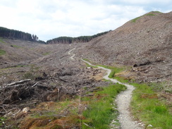
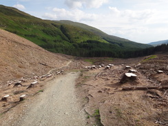
Except it was not a woodland. The entire area had been cleared and replaced with a desolate grey landscape of tree stumps and barkless branches. Whilst the clearance had granted some grand views towards Ben Nevis, it was little fun walking through such a moonscape. Indeed after a while it started to feel slight oppressive, as if the souls of the dead trees were ethereally present.
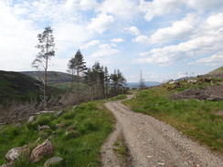
I was starting to feel tired by now and I decided to pause for a short rest at the point where a short-cut road to Fort William approaches the trail. My water bottle was nearly empty and I still had a good few miles to go - the idea of wild camping had gone out of the window and I was determined to reach the end of the trail that night. More paths headed through cleared areas of woodland, with the occasional living conifer still standing like the survivor of a massacre. Soon it entered a living forest and the views vanished.
The final part of the descent was along a track that looked as if it had recently been widened and improved - perhaps to help the clearing of the trees or (I hope not) to permit the erection of wind turbines. I shudder at the thought of the latter as the Mamores deserve to be free of such developments.
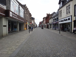
The trail dumped me out onto a road in Glen Nevis. By this time I had run out of water and was very thirsty, so it seemed sensible not to stop on my way into Fort William. On the descent I had phoned a bunkhouse in the town and they were expecting me, so I powered my way along the pavement to the roundabout on the edge of the town that used to mark the end of the trail. Last year the end had been moved a mile further on into the centre of the town, a much better place. Unfortunately that meant that I had a longer walk, so I staggered on past the hospital and railway station to reach the High Street.
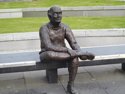
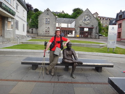
It turned out that the new end of the trail was at the far end of the town and I literally staggered down the road past what seemed like hundred of pubs. The end is marked by a metal line on the ground and an amusing statue of a walker rubbing his bootless foot; I crossed the line and collapsed down onto the bench. It was twenty pase eight in the evening; it had nearly been a twelve hour day and I was exhausted and thirsty. A passerby took the obligatory photo of me at the end of the walk and I decided to go and get a drink.
I went into the Grog and Gruel pub and ordered a pint of orange and lemonade and another of something black and heavy. I shrugged my pack off and looked back on what had been a superb four and a half days walking on a great trail - the West Highland Way has immediately gone into my list of top five trails. Many people walk it as their first trail and I can see why - it is a superb introduction to hill walking. If you do it then promise me one thing: take your time and dont try to walk it in under five days...
 |
 |
|
Directions
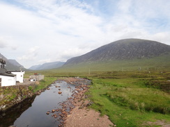
Leave the Kings House Hotel and use the bridge just behind it to cross the River Etive. Head north for a sixth of a mile down a track until it ends at a T-junction with a surfaced track at NN259549. Turn left down this track and follow it westwards for a little over half a mile. Shortly before it meets the A82(T) turn right through a wooden gate to join a rough path.
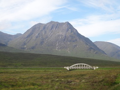
This path follows the Old Military Road as it slowly ascends west-northwestwards to summit at a height of 310 metres before descending slowly back towards the main road. On the way it crosses a couple of wooden gates; it passes another to approach the A82(T). The path heads northwestwards with the road on the left, passing through a series of gates as it squeezes between the road and some farm sheds. It eventually crosses a footbridge to reach Altnafeadh (NN220563). Pass the house and cross another footbridge over the Allt a Mhain to approach a lay-by.
After the wooded area ends a path leads off the road and up the hill to the right, initially along steps. This soon curves to the left to cross a footbridge over a gorge that carries the Allt a Mhain downhill and continues uphill with the stream on the left. At first the ascent is relatively gradual as it follows the burn, but it soon steepens and the path starts to zigzag as it ascends. This part of the path is known as the Devil's Staircase and is nowhere near as hard as it looks, even with a heavy pack. A couple of cairns mark the top of the climb, which is situated in a pass between the summits of Stob Mhic Mhartuin to the west and Beinn Bheag to the east. At 548 metres this is the highest point on the West Highland Way and there are some lovely views available of the Mamores ahead to the north and the hills of Glen Coe behind to the south.
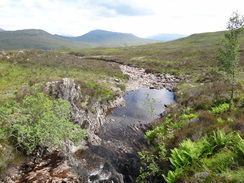
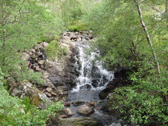
From the top of the Devil's Staircase the path starts to descend slowly to ford the Allt a Choire Odhair-Bhig. On the other side it climbs uphill once more to cross a ridge before descending to reach a bridge over the Allt a' Choire Odhair-Mhoir, where it turns to take a more northwesterly direction. It soon reaches a track next to the building that houses the top of the pipes that carry water from Blackwater Reservoir down to the Kinlochleven power station) at NN202605. This is the start of a long slog downhill, a slog which is only enlivened by the bridge that passes the attractive waterfall and dam of the Allt Coire Mhorair.
After the bridge the track becomes less steep as it continues to descend, eventually paralleling the pipeline that lead down into Kinlochleven; the track and pipeline descend together towards the site of the old aluminium factory at Kinlochleven, which was demolished in the early 2000s. Just before the site of the factory the West Highland Way turns off to the right, crossing a bridge over the pipes. A rough path then descends to reach a bridge over the River Leven at NN192617.
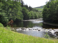
Cross the bridge, and on the northern side turn left to join a good track that parallels the river; this soon becomes Wades Road that leads northwestwards into Kinlochleven. As Morrison Crescent comes in from the right, turn left down a surfaced path that heads along the northern bank of the river into the centre of the town. It soon meets the B863 road at NN187619.
This leg starts at the B863 in Kinlochleven at NN187619, near to the Tailrace Inn. Turn left and head northwestwards along the B863 road though the town. At a bridge over the Allt Coire na Ba the road turns sharply to the left to head westwards. Follow the road as it does so and continue on along the road until you approach a school on the left.
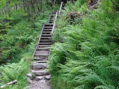
Near the school a West Highland Way fingerpost designates a path leading up the hillside to the right. Take the path as it heads sharply uphill through a wooded area, soon crossing a surfaced track that leads to the Mamore Lodge Hotel. The path continues to steeply ascend up a zig-zag with some steps. The path is obvious and easy to follow on the ground as it crosses a couple of streams. Eventually it leaves the wooded area and rises to meet another track that leads west from a TV transmission mast at NN170630.
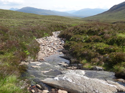
Join the track and turn left to start following it westwards. The track, part of an old military road, skirts the hillside to the north of the Allt Nathrach. Almost immediately the pretty Allt Coire na h-Eirghe stream is crossed on a bridge, which is followed a little over a mile later by the Allt Coire a' Bhutha.
The track then continues for a further mile westwards until it reaches the ruined farm at Tigh-na-sleubhaich (NN135642), next to where the Allt Coire na Sleubhaich comes down from Stob Ban to the north. This is the top of the valley, with the Allt Nathreach flowing to the east from here, and the Allt na Lairige Moire to the west.
From Tigh-na-sleubhaich the track continues westwards along a valley called the Lairig for a little under a mile, crossing a series of small streams on bridges until another ruined building at Lairigmor is reached at NN122640. This is very decrepit, even when compared to Tigh-na-sleubhaich, and comprises of little more than a jumble of fallen stones. The track continues along the southern flank of Meall Chaorainn and above the Allt na Lairige Moire as it turns from a westwards course to a northwesterly, gently undulating with the stream to the left. Eventually it meets a large area of forest by a sheepfold at NN101649 (it may be necessary to divert around the sheepfold if it is in use).
Here the track enters a wooded area and heads northwards; note that this area was cleared of its trees in 2009. After about a mile a break in the trees is reached, where there is a shelter and signboard next to a short track that leads down to a surfaced road. The road forms an alternative, shortened route north to Fort William.
The trail continues north-northeastwards from the signboard, passing into a wooded area once more before emerging into a clearing. The path over the cleared area is fairly undulating for just under a kilometre, passing through gates as it leaves the woodland before entering another area of trees. The trail is well signposted and easy to follow; forestry clearances mean that the pattern of woodland frequently changes.
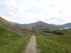
Once the path enters the woodland it soon passes over the Allt Coire a Mhuilinn (NN105682), where it turns to take a northeasterly direction. A very short break in the woods is followed by another wooded area as the path heads to the crest of Sgorr Chalum, passing through more gates as it does so. Eventually it turns to a northerly heading and descends steeply just to the west of Dun Deardail (NN127701), a prehistoric fort. Part of the descent is stepped. This whole area is part of Nevis Forest, a large forested area on the southwestern side of Glen Nevis.
The path winds, climbs and falls, crossing a stream on a footbridge before eventually reaching a wide unsurfaced track near the Allt Ghas-araich. Turn right and follow this track as it descends, winding in a rough northerly direction. Just under a mile after the track is reached a junction is met with a track coming in from the right on a lower level; continue along these merged tracks to a junction with a path called the Peat Track that leads up Crow Hill at NN118727.
Here a fingerpost indicates that the West Highland Way descends down to the right, heading downhill to the east through the trees. It emerges from the woodland to cross the Allt an Luid Dhuibh and continues on to meet the Glen Nevis Road at NN122727. Turn left down this road and follow it as it heads northwards through Glen Nevis. It soon passes the Ben Nevis Visitor Centre is on the right. The road then swings to take a northwesterly and then a westerly direction, all the time with the river away on the right. There is a good pavement on the left.
The trail used to end at the roundabout beside Nevis Bridge at NN112742; however the route was extended in 2010 to go into the centre of Fort William. Carefully cross the roundabout and continue on westwards along the A82(T) Belford Road towards the centre of the town.
As it approaches the railway station make sure you are on the left-hand side of the road. Pass the Belford Hospital on the left and then diagonally across an area of grass, passing a couple of statues on the left. Turn left to follow the High Street southwestwards. The West Highland Way ends in Gordon Square at the far end of the High Street at NN100737, next to the perfectly apt Sore Feet Statue.
 |
 |
|
Distances
| From | To | Distance (m) | Ascent (ft) | Descent (ft) |
|---|---|---|---|---|
| Kings House Hotel | Top of Devil's Staircase | 4.1 | 1234 | 233 |
| Top of Devil's Staircase | Kinlochleven | 5.1 | 377 | 2146 |
| Kinlochleven | Road junction | 7.7 | 1634 | 1066 |
| Road junction | End of WHW, Fort William | 7.9 | 1122 | 1699 |
This makes a total distance of 24.8 miles, with 4367 feet of ascent and 5144 feet of descent.
For more information on profiles, ascents and descents, see this page
Accommodation
I spent the night at the Bank Street Lodge in Fort William, a cheap place to spend the night. It is open twenty-four hours a day, and is conveniently siutated in the middle of the town.
 |
 |
|
 |
 |
|
 |
 |
|
 |
 |
|
 |
 |
|
 |
 |
|
 |
 |
|
 |
 |
|
 |
 |
|
 |
 |
|
 |
 |
|
 |
 |
|
 |
 |
|
 |
 |
|
 |
 |
|
 |
 |
|
 |
 |
|
 |
 |
|
 |
 |
|
 |
 |
|
 |
 |
|
 |
 |
|
 |
 |
|
 |
 |
|
Disclaimer
Please note that I take no responsibility for anything that may happen when following these directions. If you intend to follow this route, then please use the relevant maps and check the route out before you go out. As always when walking, use common sense and you should be fine.
If you find any information on any of these routes that is inaccurate, or you wish to add anything, then please email me.
All images on this site are © of the author. Any reproduction, retransmissions, or republication of all or part of any document found on this site is expressly prohibited, unless the author has explicitly granted its prior written consent to so reproduce, retransmit, or republish the material. All other rights reserved.
Although this site includes links providing convenient direct access to other Internet sites, I do not endorse, approve, certify or make warranties or representations as to the accuracy of the information on these sites.
And finally, enjoy your walking!
Nearby walks
| # | Title | Walk length (miles) |
|---|---|---|
| 151 | Bridge of Orchy to Kings House Hotel | 12.1 |
| 152 | Kings House Hotel to Kinlochleven | 8.7 |
| 153 | Kinlochleven to Fort William | 14.1 |
|
|

|