Walk #908: West Highland Way: Tyndrum to Kingshouse Hotel
 |
 |
|
General Data
| Date Walked | 03/07/2011 |
| County | Strathclyde, Central Scotland, Highlands |
| Start Location | Tyndrum |
| End Location | Kingshouse Hotel |
| Start time | 07.20 |
| End time | 16.20 |
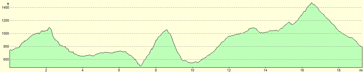
| Distance | 19.4 miles |
| Description | This walk was a glorious day's walk following the West Highland Way along a series of tracks; the ascents and descents are generally easy and the views - especially from the crossing of the Black Mount - superb. |
| Pack | Today I carried my Macpac Glissade rucksack containing my North Face Westwind tent, spare clothes, waterproofs, water, and enough food to last three days. In total it weighed about thirty-five pounds. |
| Condition | The biggets problem today was that I slightly twisted my left ankle - the sort of injury that I can usually walk on for a day or two until it fixes itself. Otherwise I feel fine, although am slightly sunburnt on my upper arms. |
| Weather | In common with the past couple of days, today started bright and sunny before clouding over slightly. There was plenty of sun throughout the day, however, and it felt quite warm on the ascents. |
| OS map | Landranger number 50 (Glen Orchy & Loch Etive) and Landranger number 41 (Ben Nevis, Fort William & Glen Coe) |
 |
 |
|
Map of the walk
Maps courtesy of Google Maps. Route for indicative purposes only, and may have been plotted after the walk. Please let me have comments on what you think of this new format. For a detailed table of timings for this walk, please see the table file.
 |
 |
|
Notes
I awoke early in the morning to find what seemed like thousands of midges inside my tent. An examination of the zips showed that they were all fully closed so it is a wonder how they got in - there were no obvious holes and the tent seemed well sealed. Cursing, I examined the many bites I had on exposed skin. Worse, my stomach was still playing up. I killed as many of the beasts before packing up as much of my gear as possible within the tent.
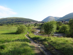
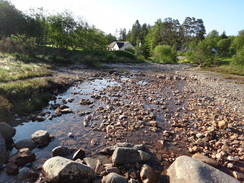
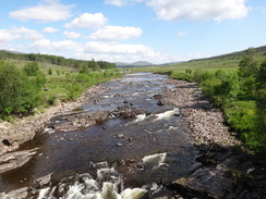
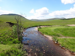
It then became a case of taking down my tent as quickly as possible before heading off along the trail. This led past a beautiful stretch of stream before reaching the village of Tyndrum proper. The village is dominated by the busy road that passes through and there were a couple of shops. I went into one to buy some provisions and munched these as I took the track that led out of the village.
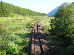
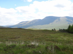
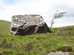
I was very much looking forward to todays walk; ten years ago I walked the northern third of the West Highland Way as part of another walk, and I had fond memories of the route above the Bridge of Orchy. Those memories powered me on as the path crossed over the railway line and joined an old military road that provided relatively easy and level walking. Unfortunately this did not last for long; a stiff but thankfully short climb led down to a cattle creep under the railway line, after which the trail rejoined the military road as it descended down into the valley of the Allt Kinglass. The railway line made a graceful curve around the valley to the right as the trail crossed the river on a bridge.
The military road started to climb gently up the hillside as it headed northwestwards, eventually meeting and crossing the railway line once more. Good views were ever-present on this stretch and I found myself really enjoying the walk. All too soon the railway station at Bridge of Orchy came into view and I followed the trail as it descended through the hamlet to reach the hotel by the main road. This seemed as good a place as any to stop for a break, so I sat down on the steps and scoffed a pork pie.
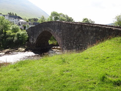
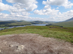
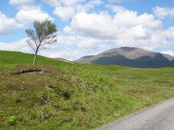
Something made me want to continue, and so I set off once more along the trail. This crossed the eponymous bridge over the river before climbing steeply through the wooded hillside to the west of the river, still following the old military road. Views assailed me as it finally broke out of the trees and before I knew it I had diverted off to the summit cairn of Mam Carraigh where the landscape unfolded all around me. It was a literal high and I felt as though I was in heaven - it was a superb spot.
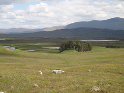
The descent down to the road at Inveroran granted good views over Loch Tulla which sparkled in the bright sunshine. Before I knew it I was standing outside the Inveroran Hotel, where a couple were having a drink at the tables outside. As I was ahead of schedule it seemed like a perfect place for a stop, so I bought a pot of tea and lovely slice of cake and sat down. The couple were from Glasgow and were walking the trail in sections, doing one day every weekend. They soon finished their drinks and set off, leaving me to feed a friendly little blue tit crumbs from my cake.
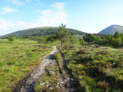
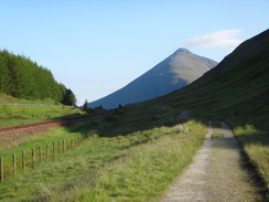
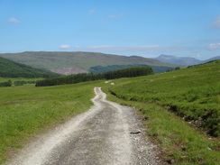
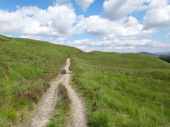
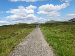
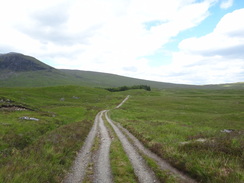
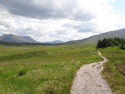
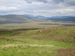
Soon I shouldered my pack and headed off once more. The next stretch of path followed a road to Victoria Bridge before joining the military road over the Black Mount. This was the main road until the new, lower road opened in the 1930s and the going was good with a gentle gradient taking me uphill. My fond decade-old memories of this walk were more than lived up to, with fantastic views over Rannoch Moor to the east and sculpted mountains to the west. It is a heavenly and surprisingly easy walk, especially in todays good weather.
I cannot put into words how this stroll made me feel; some people would understandably prefer the high mountains that lie just to the west, but for me the stroll along the track and the view over Rannoch Moor were sublime. A few hours walk along this stretch made me feel better than some whole trails - it is perfection and, better yet, perfectly accessible. The ascents and descents are relatively gradual - as befits an old road - and every step is rewarded with grand vistas.
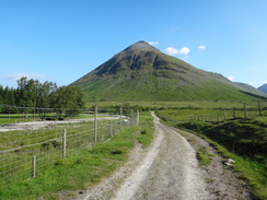
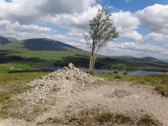
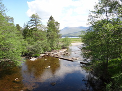
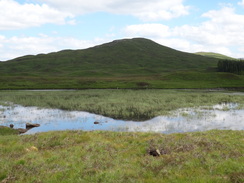
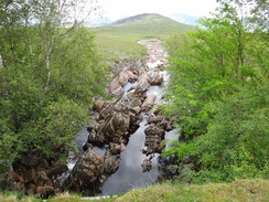
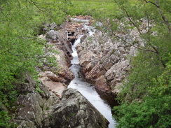
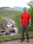
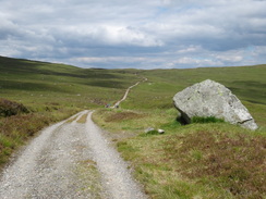
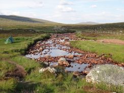
Eventually the track descended to reach Ba Bridge, where it crosses a rocky defile that carries the River Ba from its source on Aonach Mor. It is a magnificent spot with slanted slabs of rock projecting from the white water. The Glaswegian couple were having their lunch and we chatted as I dropped my rucksack off and stared down at the water churning below. The couple headed off and I strolled around the boggy sides of the stream to take some pictures.
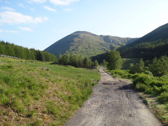
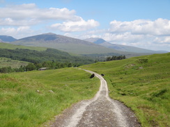
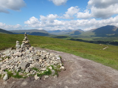
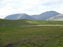
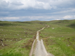
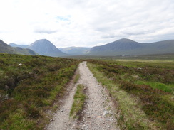
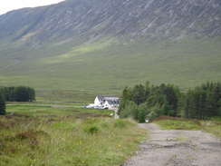
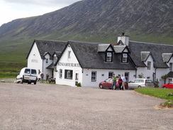
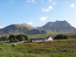
The track started to climb, aiming for a wide bealach between two hills. The views of Rannoch Moor were now behind me and as I reached the summit of the track (marked by a cairn on the left) the views switched to encompass the dramatic hills of Glen Coe. A long descent followed along the track, which was uneven and rocky in places. The white buildings of the Kings House Hotel were visible far below, as were the Glaswegian couple ahead of me.
I was nearing the surfaced road that leads up to the Glen Coe ski resort when I went over on a rock, my left ankle turning nastily. I fell to the ground and said something akin to "oh bother", although possibly much less polite. I got up and tested my foot; it ached but seemed to be able to support my weight. Since I was only two miles away from the hotel I limped on, being careful not to put my left foot on anything uneven.
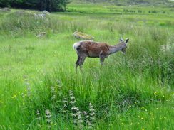
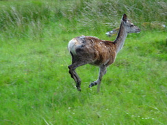
It should have been a dispiriting couple of miles but the scenery prevented my mood from dropping. There was something even better as I approached the hotel - a deer was being closely photographed by people in the car park. It look unconcerned as people were snapping photographs and I took a few as well - the hotel staff feed them for exactly this reason.
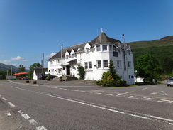
Sencan had booked me a room for the night - this seemed sensible because of the terrible midges that the Kings House campsite is famous for and because I would have access to a toilet in the middle of the night - as it happens this was a very wise decision. The room cost only thirty pounds but was situated above the bar.
After a shower and a meal downstairs I logged onto the free Internet that the hotel provides. I was amazed to find that the hits on my website had gone up massively in the last couple of days because of an article in the Guardian online that had favourably mentioned britishwalks.org. My left ankle was slightly swollen but I was almost walking on air as I headed to bed. It had been a superb days walk through captivating terrain.
 |
 |
|
Directions
Turn left along the road near the railway station, and as the road curves to the left turn right through a wooden clapper gate to continue along a path that heads northwards with a stream on the right. It fords a wide, erratic-strewn stream and continues across rough land to join the end of a surfaced road that leads past some houses to reach the A82 in Tyndrum at NN327306.
Carefully cross the A82 and head on northwards uphill along a road, passing the village hall and a new graveyard on the left. After the village hall it becomes an unsurfaced track and later goes through a gate with the A82 off to the left. 0.8 miles after crossing the man road, the track reaches two bridges that lead over a stream and then the railway line.
On the other side of the bridge the track turns to the left to head northwards with the railway line on the left. After 0.8 miles cross a stile beside a gate as the track curves to the left to descend towards the railway line; do not follow the track and instead turn right to take a path that heads slightly up the hillside to continue northwards. It summits by a small cairn and drops steeply to reach the railway line at NN328334.
The path passes under a narrow cattle creep and crosses a stile before descending a short distance to rejoins the Old Military Road. Turn right and follow this northwards as it slowly descends for 1.4 miles until a gate is reached. Cross the stile beside the gate to reach a bridge over the Allt Kinglass at NN326357.
Cross the stone bridge and then turn left to cross a stile to continue along the Old Military Road as it heads northwestwards with the railway line high to the right. The old road slowly climbs up the hillside to join the railway line. After 1.3 miles it reaches a stile beside a gate; cross the stile and turn right to cross the railway line on a bridge. On the other side of the bridge the track turns to the left to continue northwestwards, this time with the railway to the left.
Continue on along the military road for another 1.6 miles until Bridge of Orchy railway station is approached on the left. Pass the station and then immediately turn left through a metal gate and down a few steps to head through an underpass that leads under the railway line to reach Station Road. Turn right along the road; it soon curves to the left to head westwards for a couple of hundred yards to reach the A82 in Bridge of Orchy at NN297396 opposite the Bridge of Orchy Hotel.
Carefully cross the A82 and continue on westwards down the road, immediately passing the Bridge of Orchy Hotel on the left. The road descends to the eponymous bridge over the River Orchy. Cross over the bridge and, a few yards after the road turns sharply to the right, take a footpath that leads off to the left (do not take the more obvious track beforehand).
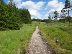
The path crosses a boardwalk across a boggy area of ground before rising up the hillside to the west of the River Orchy in a general northwesterly direction, still following the Old Military Road. It soon crosses a gate through a deer fence to enter some woodland. The path continues to climb; after about a kilometre it breaks out of the forest and continues to climb to reach a summit. A short path leads up to a cairn at the summit of Mam Carraigh, from where some lovely views over the Black Mount and Loch Tulla are available. An obvious path then descends, zigzagging down to a road near to the Inveroran Hotel at NN274413.
Turn left down the road and follow it across a bridge over the Allt Orain and past the Hotel. A bridge carries the road over the Allt Tolaghan, which drains into Loch Tulla, and then curves to the right to head northwards. It passes a small car park on the left and crosses Victoria Bridge over the Abhainn Shira. A short distance later Forest Lodge is reached at NN270423.
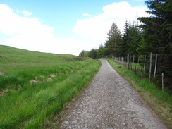
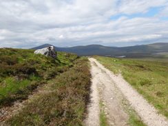
At Forest Lodge leave the road and head straight on through a small gate to join the Old Glencoe Road. This slowly ascends northeastwards and the going is very easy, with a wide unsurfaced road making for fast going; all the burns are crossed by good bridges. The track starts skirting to the western edge of a conifer plantation, the end of which signifies the end of the first rise.
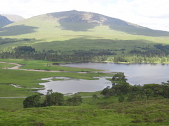
The track continues in a rough northerly direction, crossing over the Allt Doire Mhic Laimh and then to the east of a small wooded area. It then starts a slight descent down to the west of another wooded area and the weed-filled Lochan Mhic Pheadair Ruaidh. After four miles it descends to reach the River Ba. Some lovely views are available along this section, with Coireach a Ba visible to the west and Rannock Moor to the east.
The River Ba is crossed by means of Ba Bridge, and after this the track starts to rise slowly as it heads north. It reaches a high point of about 445 metres near NN282511 before starting to descend slowly as it skirts the eastern flank of Gualann Laith Ghiubhais. As it does so it changes from a northerly to a northwesterly direction, and the track becomes increasingly rough. At all times it is distinct on the ground and easy to follow.
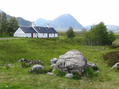
After 3.4 miles it goes through a metal vehicle barrier and approaches a surfaced road opposite Blackrock Cottage (NN267530). Turn right to join this road and follow it northwards for about six hundred yards until you meet the A82(T) road at a triangular junction; take the left-hand branch to reach the main road. Carefully cross the road and go through a gate to join a track that heads northwestwards for three-quarters of a mile along a decrepit surfaced road to reach the Kings House Hotel at NN259546.
 |
 |
|
Distances
| From | To | Distance (m) | Ascent (ft) | Descent (ft) |
|---|---|---|---|---|
| Tyndrum campsite | Bridge of Orchy | 7.0 | 699 | 909 |
| Bridge of Orchy | Inveroran | 2.5 | 607 | 561 |
| Inveroran | Ba Bridge | 5.2 | 673 | 213 |
| Ba Bridge | Kingshouse | 4.7 | 495 | 741 |
This makes a total distance of 19.4 miles, with 2474 feet of ascent and 2424 feet of descent.
For more information on profiles, ascents and descents, see this page
Accommodation
I spent the night at the Kings House Hotel in Glen Coe; my single room cost me thirty pounds for the night. There is a wild camping spot beside the river and teh hotel, but the hotel do not open their toilets in the morning for campers. They do, however, offer breakfasts to walkers who are hungry enough. They have a website at www.kingy.com.
 |
 |
|
 |
 |
|
 |
 |
|
 |
 |
|
 |
 |
|
 |
 |
|
 |
 |
|
 |
 |
|
 |
 |
|
 |
 |
|
 |
 |
|
 |
 |
|
 |
 |
|
 |
 |
|
 |
 |
|
 |
 |
|
 |
 |
|
 |
 |
|
Disclaimer
Please note that I take no responsibility for anything that may happen when following these directions. If you intend to follow this route, then please use the relevant maps and check the route out before you go out. As always when walking, use common sense and you should be fine.
If you find any information on any of these routes that is inaccurate, or you wish to add anything, then please email me.
All images on this site are © of the author. Any reproduction, retransmissions, or republication of all or part of any document found on this site is expressly prohibited, unless the author has explicitly granted its prior written consent to so reproduce, retransmit, or republish the material. All other rights reserved.
Although this site includes links providing convenient direct access to other Internet sites, I do not endorse, approve, certify or make warranties or representations as to the accuracy of the information on these sites.
And finally, enjoy your walking!
Nearby walks
| # | Title | Walk length (miles) |
|---|---|---|
| 149 | Killin to Gleann Meran | 18.1 |
| 150 | Gleann Meran to Bridge of Orchy Hotel | 11.1 |
| 151 | Bridge of Orchy to Kings House Hotel | 12.1 |
|
|

|