Walk #910: Waterbeach to Newmarket via the Devil's Dyke
 |
 |
|
General Data
| Date Walked | 22/07/2011 |
| County | Cambridgeshire, Suffolk |
| Start Location | Waterbeach Station |
| End Location | Newmarket bus station |
| Start time | 06.52 |
| End time | 13.54 |
| Distance | 19.6 miles |
| Description | This was an easy and pleasant stroll, following the River Cam and the historic Devil's Dyke through eastern Cambridge and western Suffolk. |
| Pack | Today I carried my 30-litre Karrimor rucksack, filled with water, my waterproofs, a couple of books and other odds and ends. |
| Condition | I feel fairly okay after this walk; I had a slight ache in my left ankle that was annoying more than anything else. I am rather paranoid about aches in the ankle, however. |
| Weather | Today started off bright and sunny, and consequently slightly chilly first thing. It soon started to warm up as clouds started to gather. All in all it was a very pleasant day for a stroll. |
| OS map | Landranger number 154 (Cambridge & Newmarket, Saffron Walden) |
 |
 |
|
Map of the walk
Maps courtesy of Google Maps. Route for indicative purposes only, and may have been plotted after the walk. Please let me have comments on what you think of this new format. For a detailed table of timings for this walk, please see the table file.
 |
 |
|
Notes
It had been a couple of weeks since my last walk and I was keen to get a few more miles under my belt. Many years ago I had walked the Devils Dyke, a seven-mile long dark ages bank and ditch that heads northwestwards from the edge of the Fens past Newmarket. Although I had walked it many times before, I had never taken any photographs and I was keen to revisit it.
A quick look at my website showed several different routes involving the whole of the dyke. In the end I decided to set off from Waterbeach station and walk to Newmarket; sadly this would involve a fair bit of road walking from the end of the dyke into the horseracing mecca. A surprising number of cars were already parked up in Waterbeach station car park when I arrived, and I bought a ticket before slowly pulling my kit together.
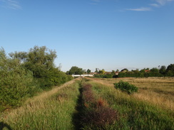
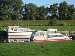
The short stretch of the River Cam past Waterbeach is one of my favourite walks; in sunny weather it can be sublimely beautiful. Although there is no vista of high mountains the blue waters of the Cam and the green flood banks can look heavenly, an impression aided by the fact that I have very fond memories of when I lived in the area.
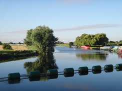
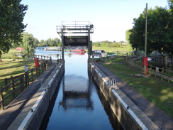
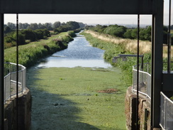
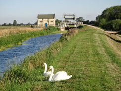
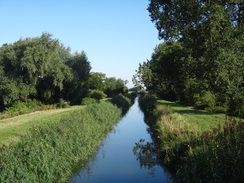
Initially I followed the Fen Rivers Way from the railway station to the banks of the Cam, and then followed it northwards in glorious sunshine to Bottisham Lock. It was quite chilly despite the sunshine and felt more like late autumn that July; some parts of the country had suffered a ground frost overnight. I crossed the river at the lock, which as always was looking superb, then followed the eastern bank of the river northwards.
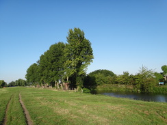
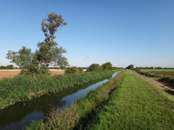
It soon crossed the entrance to Bottisham Lode, which heads inland towards the small hamlet of Lode. Lodes are a unique feature of the Cambridgeshire Fens, a series of arrow-straight channels that cross the landscape from the Cam and Great Ouse. Some are far older than the drained land that they pass through and were possibly used from ancient times to allow boats to get from the rivers to ports on the edge of the marshy land. Some are still navigable although others are now only used for drainage; all stand well above the surrounding land.
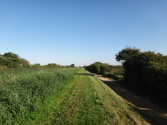
The floodbank headed northwards past a horse run on the right; a couple of horses were being ridden around as I passed. Soon Swaffham Lock was reached at the entrance to Swaffham Bulbeck Lode and I crossed a wide bridge to reach the northern side. From here I had a choice; I could either follow the wide track at the base of the bank or the grassy path along the top. Fortunately the latter had recently been cut because at times the vegetation can be nearly impassable. The weeds at the waters edge had not been cut, however, meaning that I only occasionally got views over the water. I chose to walk on both the track and the bank, frequently swapping between the two as gaps in the vegetation offered me glimpses of the water
A new bridge has been built over the lode at the point I turned off it; this is part of the Lodes Way, a recently-opened 9-mile cycleway that runs from Bottisham to Wicken. Unfortunately the next stretch to the village of Reach involved some road walking, although the roads were thankfully fairly quiet. To avoid the roads I also used a track called the Black Droveway, which unfortunately is not a public right-of-way but was wide and easy to follow.
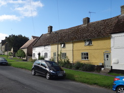
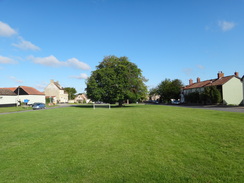
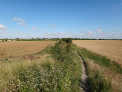
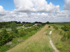
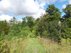
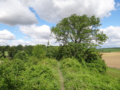
The small village of Reach is pretty and fairly unspoilt. It is centred on a small linear village green that lines up perfectly with the northwestern end of the Devils Dyke and the southeastern end of Reach Lode. After stopping to take some photos I climbed up the path that led onto the dyke.
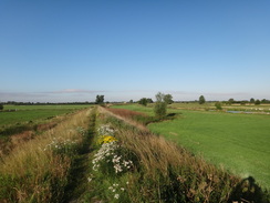
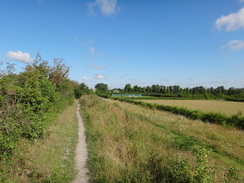
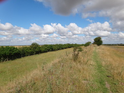
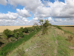
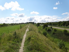
Little is known about the origins of this massive seven-mile long earthwork. It is believed to have been constructed in Anglo-Saxon times although it could possibly have an earlier core. There are many such dykes in the country (for instance Offas Dyke on the Welsh border) and several others in the local area, but the Devils Dyke is perhaps the best preserved. It is likely to have been built for defensive purposes against competing tribes in the post-Roman years. The northwestern end of the dyke lines up perfectly with Reach Lode that stretches into the Fens, and it is believed that the two could have been constructed at the same time, with the lode preventing a flanking manoeuvre through the surrounding marshland. Whatever its purpose, it looks as though it soon fell into disuse.
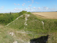
The best-preserved stretch of the dyke is at its northwestern end, and I soon had good views over the surrounding flat lands. Swaffham Prior windmill became visible on a ridge to the right before the path descended down to cross the old Cambridge to Mildenhall railway line that bisects the dyke. This offered a perfect cross-section through the bank and revealed the gleaming chalk from which it was constructed.
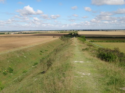
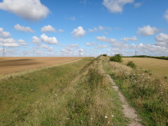
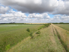
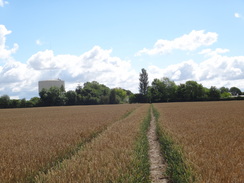
The bank lowered slightly as it approached the Burwell Road, but immediately on the other side came the most spectacular stretch of the dyke, revealing its full 11-metre height from the deep ditch below. Sadly the views were slightly spoilt by power lines that crossed the ditch near the road. What followed was a superb walk along the dyke as it headed across farmland, with good views over the flat farmland on all sides.
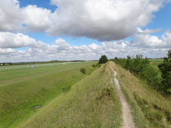
Soon traffic noise started to intrude, the roar getting louder as I approached the bridge that carries the path over the A14(T). Some steps on the other side led down to a flat area of grassland with white barriers - part of the Newmarket Racecourse. Off to my left was the Rowley Mile Course with the Millennium Grandstand in the distance, whilst the July Course was off to the right. The gap was not wide, and soon I was climbing back up onto the bank.
I have often wondered if the public are allowed to walk this path during a race meeting; if so then it must be possible to get some grand views of the horses. The dyke has been cut through at various points along the racecourse and a series of steps helps negotiate these. A lorry trailer carrying a large television screen - one commonly used in outdoor broadcast - was parked near the dyke, and it generally looked as though they were getting the July course ready for a meeting.
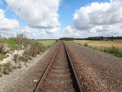
Eventually the dyke dropped down to meet the A1304 road; this had to be crossed with care before the path climbed back up onto the top of the dyke. This started to climb as the surrounding ground ascended a slight slope; it was an attractive stretch to walk and one that ended all too soon as it descended to reach the Newmarket to Cambridge railway line.
A man was trying to negotiate the clappergate that leads to the railway whilst holding a small girl in his arms and the leashes of two dogs in one hand. I waited patiently as girl and leashes were expertly juggled between his hands before overtaking him and crossing the line.
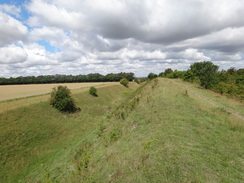
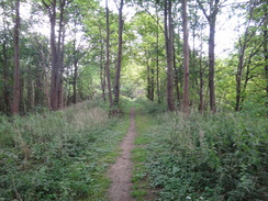
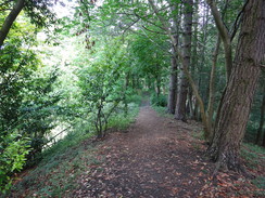
The next stretch of dyke was very short, ending at a minor road. Here I discovered that my cameras battery had run out, so I sat down on some steps to change it. Where the previous sections of the dyke had been open and airy, the next was enclosed by brooding woodland. It also became harder going underfoot and generally rougher; it was a shame that the vegetation blocked what should have been grand views.
It reached the summit of a small hill with the Stetchworth Park Stud off to the right, another indication of the horseracing industry that so dominates this rural area. In places the ditch to the right appeared to be quite deep, perhaps as deep as it had been near Burwell.
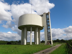
Eventually the bank petered out near Ditton Green and the path descended to follow the edge of a field, then cut across it to reach a road beside a massive water tower that dominates the local area. Here I was left with a choice; there are few paths that lead directly towards Newmarket and so a certain amount of road walking was required. As I had only walked about fifteen miles it seemed sensible to extend the walk and I decided to follow roads northeastwards.
The pub in Ditton Green was not due to open for another twenty minutes, and instead of waiting I continued along the road through Little Ditton towards Saxon Street. A pub was marked on the map, and so I diverted off to reach it. The first door I tried was locked, but a second on the side was open. I was very lucky as the pub does not open on Monday to Thursday lunchtimes, meaning that I had picked the prefect day of the week on which to do the walk!
I had my usual drinks whilst I scoffed down a rather large pack of pork scratchings. For some reason my feet were aching far more than they usually do after such a walk, but it did not seem the sort of place where I could slip my boots off. I also had not taken enough water with me for what was a surprisingly warm day, and the alcohol soon went to my head.
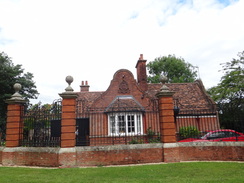
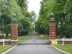
Unfortunately I did not have much alternative except to walk to Newmarket along roads. This plod was enlivened by the spectacular gateways that lined the road, each leading into various stud farms. There is obviously a great deal of money in horseracing, and some of it was focussed on this rural road.
The road descended all the way into the town, a surprising indication of how much the Devils Dyke had risen from the low-lying Fenland. On the way in it passed a large area of grassland on the right, yet another horsey area.
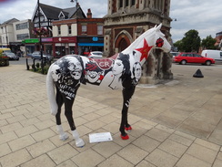
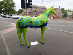
Although I had visited Newmarket many times over the years, I could not remember where the bus station was. I had to ask a couple of people before I stumbled upon it near the main shopping centre, passing some gaily-painted horse sculptures on the way. The next problem was that I could not find the bus timetables for the coaches that I knew called at the town.
The journey back was entertaining; a coach to Cambridge pulled in and I sat on one of the jump seats at the front so that I could stretch my legs out. However some elderly ladies got on at a later stop and so I went to sit further back. A fit-looking, muscular young man was sitting alone on the wide back seat, and after a while I noticed that he was scrawling lines on the floor with a thick black marker. It was some form of tag, and so I said, "excuse me," and shook my head.
A look of embarrassment flashed over his face as he stared at me. Then we both looked away from each other, but as I glanced back occasionally I saw him staring angrily back at me. He got off on the outskirts of Cambridge and as he walked past he gave me a little nudge. Many people defend graffiti by calling it an art form, but I fail to see how tagging the floor of a bus could in any way be called an art.
The walk along the Devils Dyke had been highly enjoyable, and the walk as a whole was a trip down memory lane. It was a walk that I can easily imagine doing again sometime in the future.
 |
 |
|
Directions
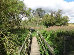
This walk starts at Waterbeach station car park. Leave the car park and head north to the road right beside the level crossing and station. Go through a little pedestrian gate and continue north along a track, with the railway line on the left. Soon the path leaves the track and curves to the right, heading through more gates.
It passes a junction with another footpath on the right (the Fen Rivers Way). Continue eastwards with a hedge on the left along the obvious footpath as it skirts a boatyard on the right. When the hedge ends the footpath curves to the right to join the western bank of the River Cam. Turn left and follow the flood bank as it winds in a rough northerly direction for about half a mile until Bottisham Lock is reached at TL507656. Pass through a gate that leads to a surfaced path that leads across the lock.
Cross the lock and on the other side go through a pedestrian gate that leads into a field. Turn left to start following the path northeastwards along the eastern bank of the river. It soon reaches the entrance to Bottisham Lode; cross the stiles and the bridge to join the flood bank on the northern side. Follow this for a little over a mile as it winds northeastwards, eventually reaching Swaffham Lock at TL522672.
Cross the bridge and on the other side turn right to start following the northern flood bank of Swaffham Bulbeck Lode southeastwards. You can either walk along the top of the flood bank or the track that runs at its base. Continue for about 1.5 miles to TL539653, just before a bridge over the lode. Here turn left to follow a road northeastwards; it soon passes Slades Farm on the left.
A T-junction is reached with another road after half a mile; turn right to follow this southeastwards for a little over half a mile until a track called Black Droveway is reached at TL552652. Turn left and follow this track as it heads northeastwards for another half mile; it passes a large barn on the left before reaching another road. Turn right and follow it as it immediately curves to the left, heading northeastwards towards Reach. The road curves sharply to the right as it enters the village, and then to the left and right once more to reach the village green.
Keep the village green to the left as you walk through the village; near the top (southeastern) end, climb up a path that leads onto the end of the Devils Dyke. Keep to the top of the bank as it starts to head southeastwards; after two-thirds of a mile it reaches the course of the old Cambridge to Mildenhall railway line. The path diverts off to the right of the bank, descending down steps to reach the shallow cutting that used to carry the railway. Cross this, and on the other side take some steps that climbs back up to the top of the bank. After another third of a mile the path descends once more to reach the B1102 Burwell Road at TL580648.
Carefully cross the road and climb up the bank on the other side. The next stretch of the dyke is perhaps the most impressive as it climbs a small hill; the bank is high and the ditch to the right deep. The ditch continues arrow-straight for 1.7 miles, eventually reaching the A14 at TL600630.
Climb the steps and cross the footbridge over the road; on the other side descend down the steps to reach a flat area of grassland. Head straight on across this, ducking under the white railings that protect the Running Gap in the racecourse. On the other side of the second line of railings climb some steps that lead back up onto the dyke.
The next one and a half miles heads across the gap between the Rowley Mile and the July racecourses. It remains on the bank for most of the time, only dropping down to cross a couple of gaps. Wooden steps make it easy to clamber up and down the bank at the gaps.
The next interruption is at the A1304. The dyke descends to a little car park; head straight on along some grass for a short distance to reach the road and carefully cross it. On the other side it clambers back up onto the bank and heads a mile southeastwards before approaching the Newmarket to Cambridge railway line at TL630604.
Go through a clappergate and descend some steps to the railway line; carefully cross this and climb some more steps and go through another gate to rejoin the top of the bank. This continues in the same direction for about 150 yards before descending down to another road. Cross this and on the other side climb up another set of wooden steps to rejoin the top of the bank.
The bank slowly climbs up a slope for three-quarters of a mile before descending to a road at TL641595. Cross this and climb back up the bank. It continues through trees; in places it is far more enclosed than previous sections. After about a mile it emerges into a field; continue on with the woodland to the right for about fifty yards before turning to the left to had diagonally across a field, aiming just to the right of a large white water tower. At the end of the field the path follows a hedge on the right, passing gardens before ending at a road in Ditton Green at TL656580.
This marks the end of the stroll along the Devils Dyke, and the rest of the walk takes us down into Newmarket. Turn left and follow this road towards the village; it soon curves to the right to head southeastwards, and then left to head east-northeastwards for a third of a mile to a crossroads in Woodditton. Cross the crossroads and continue northeastwards for half a mile to reach another crossroads in Little Ditton.
Cross this and head straight on northeastwards for another four-fifths of a mile along School Lane until it ends at a T-junction with another road at TL677595 in Saxon Street. The Reindeer Pub is about fifty yards to the right. If you do not want to visit the pub then turn left to follow the road north-northwestwards for about two and a half miles as it slowly descends downhill. A pavement eventually starts on the right, allowing safer walking before the road ends at a crossroads with the B1103 at TL653630.
Carefully cross the road and join the B1603 as it heads up a slight hill. At the top it curves to the left to head west-northwestwards down into the village of Newmarket before ending at a complex roundabout with the High Street at TL645635. Cross the roundabout and follow Exeter Road northwestwards to another junction. Follow the road as it curves around to the left towards a shopping centre on the left; Newmarket bus station is on the left at TL634636.
 |
 |
|
Distances
| From | To | Distance (m) | Ascent (ft) | Descent (ft) |
|---|---|---|---|---|
| Waterbeach station | Reach | 6.3 | 30 | 10 |
| Reach | Ditton Green | 7.9 | 509 | 161 |
| Ditton Green | Newmarket bus station | 5.4 | 112 | 400 |
This makes a total distance of 19.6 miles, with 651 feet of ascent and 571 feet of descent.
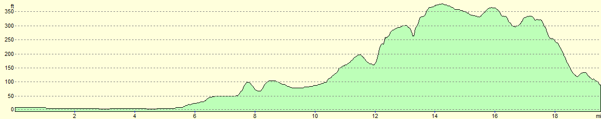
For more information on profiles, ascents and descents, see this page
Transport
It is easy to return to Waterbeach using public transport. Stagecoach run regular coach services (route 12) from Newmarket Guineas Bus Station to Drummer Street in Cambridge; you then need to walk the half-mile to Cambridge railway station, from where trains run regularly back to Waterbeach station.
 |
 |
|
 |
 |
|
 |
 |
|
 |
 |
|
 |
 |
|
 |
 |
|
 |
 |
|
 |
 |
|
 |
 |
|
 |
 |
|
 |
 |
|
 |
 |
|
 |
 |
|
 |
 |
|
 |
 |
|
Disclaimer
Please note that I take no responsibility for anything that may happen when following these directions. If you intend to follow this route, then please use the relevant maps and check the route out before you go out. As always when walking, use common sense and you should be fine.
If you find any information on any of these routes that is inaccurate, or you wish to add anything, then please email me.
All images on this site are © of the author. Any reproduction, retransmissions, or republication of all or part of any document found on this site is expressly prohibited, unless the author has explicitly granted its prior written consent to so reproduce, retransmit, or republish the material. All other rights reserved.
Although this site includes links providing convenient direct access to other Internet sites, I do not endorse, approve, certify or make warranties or representations as to the accuracy of the information on these sites.
And finally, enjoy your walking!
Nearby walks
| # | Title | Walk length (miles) |
|---|---|---|
| 2 | Waterbeach to Newmarket Road, Cambridge | 5.4 |
| 5 | A short walk around Waterbeach to Car Dyke | 3.0 |
| 6 | Waterbeach to Newmarket Road, Cambridge | 5.4 |
|
|

|