Walk #326: Totnes to Blackpool Sands
 |
 |
|
General Data
| Date Walked | 14/01/2003 |
| County | Devon |
| Start Location | Totnes |
| End Location | Blackpool Sands |
| Start time | 08.50 |
| End time | 16.20 |
| Distance | 17.7 miles |
| Description | This was a long walk of two halves; an initil walk don the western bank of the River Dart to Dartmouth was followed by a walk south and westwards along the South West Coast Path. |
| Pack | Today I carried my 30-litre Karrimor HotRock rucksack, which was filled with my packed lunch, waterproof leggings, water bottle and a couple of spare shirts, together with the usual assortment of odds and ends. |
| Condition | I found this walk hard, particularly early on, as I was not feeling very well. As the walk continued I started to feel slightly better, and by the end of the walk I could easily have walked further if daylight had allowed. My ankle and the new boots gave me no bother, which I am very relieved about. |
| Weather | Today was a quite cloudy day, but it was also quite warm for the time of year, especially when you compare it to the day before yesterday. The wind was quite cold, but out of it I was quite warm and I ended up taking my fleece off as I was overheating as I was climbing the hills. Fortunately there was no sign of any rain and it was a dry day, despite the cloud. |
| OS map | Landranger number 202 (Torbay & South Dartmoor, Totnes & Salcombe) |
 |
 |
|
 |
 |
|
Map of the walk
Maps courtesy of Google Maps. Route for indicative purposes only, and may have been plotted after the walk. Please let me have comments on what you think of this new format. For a detailed table of timings for this walk, please see the table file.
 |
 |
|
Notes
For periods on the walk from Totnes down to Dartmouth I was following markers on signposts denoting the River Dart Trail, the same ones I followed from Kingswear to Maypolee yesterday. I do not know anything about this trail, and it appears to me as if it is more a series of interlinked walks than one continuous trail, as in a couple of places signboards gave two alternative routes of different lengths to get to the same place! This made following the signs slightly confusing in places as it was unclear which route any particular way marker follows. Hopefully the route is continuous, so you could follow it instead of my route, particularly for yesterday's walk, which had far too much road walking and wet a long way away from the river on the section to Totnes.
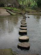
To the southwest of Ashprington I saw a footpath sign denoting a low-tide shortcut. I followed this a short distance downhill through a farm to find a series of stepping-stones over the Harbourne River. The setting was lovely, and I took a couple of photos of them before working out whether to cross them. This should have provided me with no problems crossing them as they were generally level, quite large and well spaced, but unfortunately one of the stones had been removed a few feet out of line by the river, leaving a gap, and the next one beyond it was tilted. I size up the problem for a couple of minutes before deciding to cross them, as the water was not very deep. I walked up to the missing stone along the other stones, which were thankfully dry and not slippery, and then steeled myself before jumping across the gap. I landed safely, and with a literal spring in my step I crossed the remaining stones to the other side. Later on when I looked at the Ordnance Survey Map I worked out that the time I spent crossing the stones was probably longer than the time it would have taken me to walk along the road via the bridge, but it certainly would have been less fun!
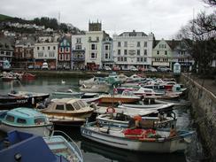
Dartmouth was beautiful, and I enjoyed walking through the town and seeing the views over the River Dart towards Kingswear. The riverfront promenade through the town was a lovely way to see it, and although I did not go to see the town's most famous building, the grade-one listed Butterwalk. The views across the boat float were quite grand, although the buildings behind were slightly spoilt by the names of the shops above the large windows. The town was where Thomas Newcomen was born, and there is an example of one of his first steam engines in a building in the town. He developed his engines to pump water out of Cornish tin mines, and I wonder how he would feel if he knew how developments of his basic engines have changed the world.
I had arranged to meet up with Sam near the church in Stoke Fleming, but about an hour before I got there I received a text message from her, saying hat she was parked at Blackpool Beach. I checked on my map and did not mind this as it was extending the walk and I was feeling fit enough to cope with this. I took a couple of minutes to look around the outside of the church in Stoke Fleming, which is dominated by a very tall tower. I suppose that it is within the bounds of possibility that the tower was built that tall to provide a navigation point to ships at sea, like the towers of some other churches that I have seen around the coat.
One of the problems with the car park where we spent the night was that we had no TV signal, which meant that we had to listen to CD's all evening before retiring to bed early. Unfortunately our taste is music is quite different, and we both took some sadistic joy in inflicting our music on the other in turns. I must admit that complaining about not having TV reception on a long distance walk makes me feel like I am really pampered. Long distance walkers should camp out each night, cover thirty miles a day and have wild, unkempt beards and hair - well, at least I fit one off those categories! Having a campervan follow me around is exceedingly handy, but I do feel as if I am losing part of the experience of the walk - as if I am insulated from the reality of my location. The van can be shut up at night, and it is easy to forget exactly where you are, something that has never happened to me in a tent.
The narrow sunken lanes in Devon are proving difficult for Sam - she is an expert driver, but driving the van down these lanes is not an easy job, particularly when a minibus comes the other way. She cannot wait to get out of this area, but unfortunately the problem shall remain for a while due to all the river estuaries that I need to walk around.
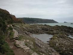
The last part of the walk from Dartmouth was following the South West Coast Path, and the stretch to Warren Point had some beautiful views along the cliffs. The last part of the walk unfortunately headed inland towards Stoke Fleming, and it is a shame to have to miss out what must be a spectacular stretch of coastline between Warren Point and Blackpool Sands.
Directions
| During this walk I followed the South West Coast Path, the route of which is detailed in the Ordnance Survey National Trail Guide 10, Falmouth to Exmouth (ISBN 1-854108-90-5). Unfortunately the route description is written in reverse to the direction that I am walking, but the 1:25,000 maps in the book are clear and the signs on the ground are very good. Also to be recommended is the South West Coast Path Association guidebook (ISBN 0-907055-04-4), which has less concise directions and no maps, but includes accommodation details and grades each section of the walk according to difficulty. They also publish reverse directions, which are suitable for walking in the direction that I walked the route. They have a website at www.swcp.org.uk, which is well worth a visit. | 
|
| 
| |
| |
| |
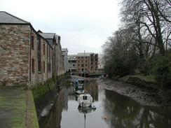
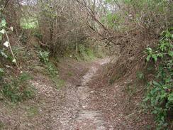
This walk starts off at the bridge over the River Dart in Totnes. Cross the bridge onto the western bank and then turn left along The Plains. Follow this road southwards past a fountain on the right and when it curves sharply to the right continue straight on down New Walk, which leads to a boatyard at Baltic Wharf. Enter the boatyard and then head uphill to the right through some gates and then left to join a footpath, part of the Dart Valley Trail. Turn left along this footpath and follow it as it heads southeastwards alongside the river.
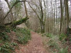
The footpath rises up and enters a small area of woodland before descending and emerging into an area of marshland on the other side. It skirts this area before climbing uphill slightly away from the river and reaching the end of an unsurfaced track directly beneath an area of woodland. Follow this track westwards, and after it goes through a gate follow the footpath as it heads off to the right uphill. The path enters an area of woodland where another unsurfaced track is joined that eventually becomes surfaced before ending at a public road near the gateway that leads into Sharpham House.
Turn right down this road and follow it downhill into Ashprington. Pass the 12th century church and continue on downhill to the bridge over Bow Creek in Bow (if the tide is low there are some stepping stones that can be used to cross Bow Creek earlier and saves a little distance; these stones are accessible through a farm to the left before the bottom of the hill and is well signposted). On the other side turn left along another road that follows the southern bank of Bow Creek before turning to the right to enter Tuckenhay. At the end of a little creek turn left along a little surfaced track that heads over a stream and then immediately turn left down a footpath that heads down along the southern bank of Bow Creek.
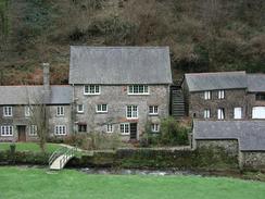
When this footpath meets the edge of an area of woodland it turns to the right to head uphill along the bottom of a little valley. The footpath eventually becomes a track and goes through a farmyard and ends at a road beside Cornworthy Church. At the church turn to the left and head uphill along a narrow lane to the southeast. When this road ends at a crossroads at the top of the hill turn to the left to head eastwards into East Cornworthy. The roads descends downhill but before it reaches a bridge over a stream take a footpath that leads off to the left. This footpath parallels the stream before descending to the right near an old mill and crossing the stream by a footbridge and ending at a road. Turn left down this road and follow it as it climbs uphill into Dittisham.
Climb uphill to the church in Dittisham and follow the road as it curves around to the right past the church. Take the first road to the left that leads down towards the ferry, and shortly after this road curves around to the left take a footpath off to the right. This ascends up a little track before turning sharply to the right to head steeply uphill. About halfway up this hill take another footpath off to the left that skirts an area of woodland before ending at a road.
Turn left along this road and follow it southwards over Fire Beacon Hill and down into Bozomzeal. Continue on along the road and before Hole is reached turn right up a footpath that ends at a track. Turn left down this muddy track and follow it as it descends steeply downhill before meeting a road. Turn left down this road and continue downhill for a short distance until the bridge over Old Mill Creek at Old Mill Cott is reached. Cross the bridge and follow Old Mill Lane as it heads steeply uphill before entering a housing estate and ending at the A379 road. When the main road is reached turn left and head down it past the Britannia Royal Naval College. At the bottom of the hill turn to the right and follow another road alongside the riverfront into Dartmouth.
From the ferry landing in Dartmouth the South West can be followed as far as Blackpool Sands, the route of which is detailed in the Ordnance Survey National Trail Guide 10, mentioned above.
Distances
| From | To | Distance (m) | Ascent (ft) | Descent (ft) |
|---|---|---|---|---|
| Totnes Bridge | Cornworthy | 5.3 | 1043 | 781 |
| Cornworthy | Dartmouth | 7.1 | 1457 | 1703 |
| Dartmouth | Blackpool Sands | 5.3 | 1230 | 1148 |
This makes a total distance of 17.7 miles, with 3730 feet of ascent and 3632 feet of descent.
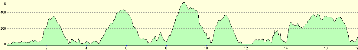
For more information on profiles, ascents and descents, see this page
Accommodation
We parked in the car park at Blackpool Sands, which seemed to be as good as any place to park. The car park sloped in two directions, but we fortunately found the only reasonably level place on the entire car park. The car park has a sign stating no overnight parking, but we chose to ignore this sign, as the car park was so convenient.
Disclaimer
Please note that I take no responsibility for anything that may happen when following these directions. If you intend to follow this route, then please use the relevant maps and check the route out before you go out. As always when walking, use common sense and you should be fine.
If you find any information on any of these routes that is inaccurate, or you wish to add anything, then please email me.
All images on this site are © of the author. Any reproduction, retransmissions, or republication of all or part of any document found on this site is expressly prohibited, unless the author has explicitly granted its prior written consent to so reproduce, retransmit, or republish the material. All other rights reserved.
Although this site includes links providing convenient direct access to other Internet sites, I do not endorse, approve, certify or make warranties or representations as to the accuracy of the information on these sites.
And finally, enjoy your walking!
This walk was mentioned in the following routes:
| My walk around the coastline of Britain |
| South West Coast Path |
Nearby walks
| # | Title | Walk length (miles) |
|---|---|---|
| 324 | Torquay to Coleton Camp | 15.0 |
| 325 | Coleton Camp to Totnes | 15.3 |
| 327 | Blackpool Sands to East Portlemouth | 17.7 |
|
|

|