Walk #325: Coleton Camp to Totnes
 |
 |
|
General Data
| Date Walked | 13/01/2003 |
| County | Devon |
| Start Location | Coleton Camp |
| End Location | Totnes |
| Start time | 08.23 |
| End time | 15.58 |
| Distance | 15.3 miles |
| Description | This was a long day with an annoying amount of road walking to be done. I also found it quite strenuous, particularly the first stretch as far as Kingswear that was quite steep in places. |
| Pack | Today I carried my 30-litre Karrimor HotRock rucksack, which was filled with my packed lunch, waterproof leggings, water bottle and a couple of spare shirts, together with the usual assortment of odds and ends. |
| Condition | The main problem today was that I was feeling slightly ill, which made the miles harder to complete. I also found that my legs did not have the energy to push me up the hills easily, and even early on in the walk I was having to stop on inclines that I should have been able to get up easily. My ankle was fine, and I am now almost ready to call my boots broken in. |
| Weather | Today was vastly different to the weather of the last few days. It was much milder, with a temperature that was probably five or six degrees higher than yesterdays. It was also fairly cloudy, and although the sun occasionally made an appearance it was a much darker day than has been the case for the best part of a week. There was a light ten-minute drizzle shower at about midday, but this was not strong or long enough to be annoying. For once I had more trouble with overheating rather than being too cold. |
| OS map | Landranger number 202 (Torbay & South Dartmoor, Totnes & Salcombe) |
 |
 |
|
 |
 |
|
Map of the walk
Maps courtesy of Google Maps. Route for indicative purposes only, and may have been plotted after the walk. Please let me have comments on what you think of this new format. For a detailed table of timings for this walk, please see the table file.
 |
 |
|
Notes
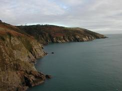
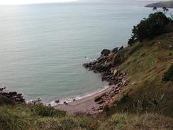
The first part of this walk was quite steep in places, and it tired me out very quickly. This was more than made up for by the views however, which were for the most part stunning and beautiful. The cliffs were magnificent, and the path seemed to go to just the right places to make the most of them. Although it was not exactly a sunny day it was bright enough to make the views worthwhile, and I savoured every minute as I toiled up and down as the path winded its way around the cliffs.
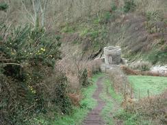
The Brownstone Battery was very interesting, and I spent a little time walking around the existing buildings. The first building I came to was one of the old searchlight positions, and this was followed by a climb up a set of rickety concrete steps towards the lower gun position, which still gave commanding views out to sea. Next to this was an old inclined railway, which led a short distance uphill to the ammunition store and was used to send ammunition down the steep slope to the lower gun.
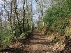
I was planning to have to walk along the A379 road from the upper ferry, one mile to the north of Kingswear, to Galmpton, a walk which I was not really looking forwards to doing. Fortunately the ferry was not running, and this meant that the road was exceedingly quiet as I walked along it. After a short distance a sign said that a footpath went away to the right to Maypole Youth Hostel; that was exactly the place that I wanted to get to ideally, but I could not understand why the path went away to the right, the opposite side of the road to Maypole. I discovered the answer a little while later, as the path crossed the road and plunged down through the woodland to the left. I decided to follow this route as it looked as though it would be more scenic than the road plod, and so it proved to be; however the path was not marked on my Ordnance Survey Map and therefore I had to trust the way markers. The path winded up and down through Long Wood, which made me even more tired, but I was rewarded with occasional lovely views of the River Dart through the trees. Eventually the path emerged out of the trees at Higher Greenway near Maypole, and from here I could follow the road to Galmpton. This was a lovely albeit strenuous diversion, and one I would most certainly recommend it over the alternative route along the road.
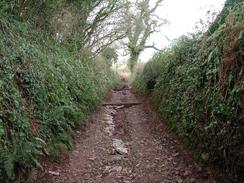
The rest of the walk to Totnes was along minor roads and green lanes, and this led to a fairly boring walk, without many good views available anywhere. The walk down and up Fleet Mill Lane was quite enjoyable however; this lane starts off surfaced but it soon becomes an unsurfaced deep sunken lane that was quite firm but very stony in places. I am hoping that the walk along the western side of the river Dart tomorrow will prove to be better; although it to involves lots of road walking it will be considerably nearer to the river than today's walk was.
In the Kingswear area I came across several plaques and references to Lieutenant Corporal H Jones, who became famous when he posthumously gained the Victoria Cross during the Falklands war.
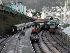
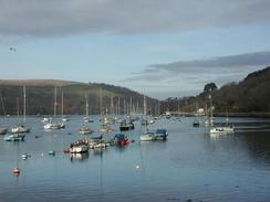
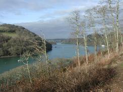
Kingswear is the terminus of the Paignton and Dartmouth Steam Railway, and I enjoyed looking at the trains in the station. Some shunting was being down by a diesel locomotive, and the first mile of the walk north of the town was between the river and the railway so I got some nice views of some of the rolling stock in the sidings. Unfortunately no services were running, and so I did not get the opportunity of seeing a steam train on the line, which could have been wonderful. The section of the Dart between the upper and lower ferries was packed with boats of all sizes and descriptions, and the marina looked fairly full, all of which looked wonderful in the morning sun, which glinted well off the water.
Directions
| During this walk I followed the South West Coast Path, the route of which is detailed in the Ordnance Survey National Trail Guide 10, Falmouth to Exmouth (ISBN 1-854108-90-5). Unfortunately the route description is written in reverse to the direction that I am walking, but the 1:25,000 maps in the book are clear and the signs on the ground are very good. Also to be recommended is the South West Coast Path Association guidebook (ISBN 0-907055-04-4), which has less concise directions and no maps, but includes accommodation details and grades each section of the walk according to difficulty. They also publish reverse directions, which are suitable for walking in the direction that I walked the route. They have a website at www.swcp.org.uk, which is well worth a visit. | 
|
| 
| |
| |
| |
The second part of the walk northwards from Kingswear to Totnes is along the eastern bank of the River Dart. From the station in Kingswear head uphill along the B3205 road, with the railway on the left. After a few hundred yards some steps lead down to a black metal footbridge that leads over the railway line. On the other side of the bridge steps lead down to a footpath that runs between the railway line on the right and a marina on the left.
Turn right and follow the footpath northwards as it follows the railway line for more than a mile northwards until it reaches the upper ferry crossing by the A379. Here the footpath ends, so turn right and cross the railway on a level crossing before following the A379 road uphill. The road winds uphill, before a permissive footpath leads off to the left. Follow this footpath as it heads through the woodland - it is well waymarked and easy to follow as it continues northwards or over a mile before it eventually emerges near the farm at Higher Greenway.
Continue on down to a road near the farm. Here turn to the right to head northeastwards for a short distance to a road junction. Here continue on to the northeast along another road that crosses over a railway line on a bridge before eventually entering Galampton. Continue through the village and pass the school before turning to the left along another road that heads westwards out of the village. This road climbs steeply uphill before heading past Waddeton and Waddeton Court before turning to the right to head northwards and descend to Port Bridge.
Cross over the bridge and then immediately take a small road that leads of to the left. This road passes to the right of a small stream before it eventually ends and a rough footpath continues on into Stoke Gabriel. Take the first road to the left that climbs uphill towards the church and past a pub. When this road ends at a T-junction turn to the left up another road past the school and follow it as it turns to the right. Near a chapel take a road to the left that heads northwards for a little over a kilometre to the village of Aish, crossing a ford on the way.
When the road ends at a T-junction in Aish turn to the left and follow another road uphill. When this road curves to the right take a track that heads straight on, descending downhill to the west for a kilometre To Fleet Mill. Cross a bridge over a stream to Fleet Mill and then turn left to head north-northwestwards uphill along a very rough track, with a stream on the right. As the track nears the top of the hill it turns to the left to a more westerly direction before joining another track that heads northwards for a short distance before ending at a road.
Turn left and follow this road as it heads downhill. When it ends at a T-junction turn to the left and continue descending down into Totnes. Pass a shop on the right and then turn left along a road that curves around before ending by the bridge over the River Dart in Totnes, which is the first crossing point over the river and also where this walk ends.
Distances
| From | To | Distance (m) | Ascent (ft) | Descent (ft) |
|---|---|---|---|---|
| Coleton Camp | Kingswear Station | 4.1 | 1342 | 1837 |
| Kingswear Station | Galmpton | 3.7 | 925 | 823 |
| Galmpton | Totnes | 7.5 | 1076 | 1194 |
This makes a total distance of 15.3 miles, with 3343 feet of ascent and 3854 feet of descent.
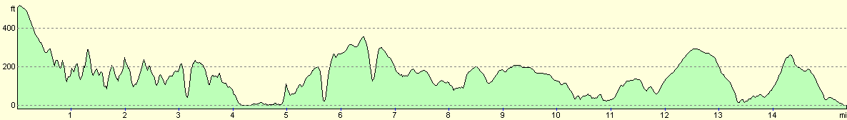
For more information on profiles, ascents and descents, see this page
Accommodation
We stayed at the campsite at Broadleigh Farm, Coombe House Lane, Aish, Stoke Gabriel, Totnes TQ9 6PU. They can be contacted on 01803 782309. This site cost us seven pounds and fifty pence for the night, and was a reasonable site foe that price, although I found that the showers were too hot for me and that I could not adjust the temperature down.
Disclaimer
Please note that I take no responsibility for anything that may happen when following these directions. If you intend to follow this route, then please use the relevant maps and check the route out before you go out. As always when walking, use common sense and you should be fine.
If you find any information on any of these routes that is inaccurate, or you wish to add anything, then please email me.
All images on this site are © of the author. Any reproduction, retransmissions, or republication of all or part of any document found on this site is expressly prohibited, unless the author has explicitly granted its prior written consent to so reproduce, retransmit, or republish the material. All other rights reserved.
Although this site includes links providing convenient direct access to other Internet sites, I do not endorse, approve, certify or make warranties or representations as to the accuracy of the information on these sites.
And finally, enjoy your walking!
This walk was mentioned in the following routes:
| My walk around the coastline of Britain |
| South West Coast Path |
Nearby walks
| # | Title | Walk length (miles) |
|---|---|---|
| 323 | Dawlish to Torquay | 16.0 |
| 324 | Torquay to Coleton Camp | 15.0 |
| 326 | Totnes to Blackpool Sands | 17.7 |
|
|

|