Walk #327: Blackpool Sands to East Portlemouth
 |
 |
|
General Data
| Date Walked | 15/01/2003 |
| County | Devon |
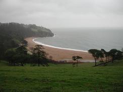
| Start Location | Blackpool Sands |
| End Location | East Portlemouth |
| Start time | 08.15 |
| End time | 16.15 |
| Distance | 17.7 miles |
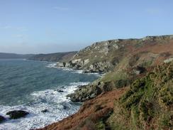
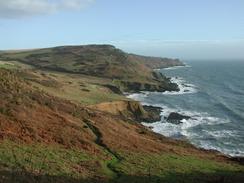
| Description | This was a lovely day with some absolutely superb views available over the cliffs. around Start Point and Prawle Point. |
| Pack | Today I carried my 30-litre Karrimor HotRock rucksack, which was filled with my packed lunch, waterproof leggings, water bottle and a couple of spare shirts, together with the usual assortment of odds and ends. |
| Condition | I feel absolutely fine after this walk, and could easily have walked further. It was an hour between when I reached Salcombe and when we walked the kilometre uphill to the van, and during that time my Achilles ceased up, which made that climb uphill quite hard and painful. |
| Weather | The day started off with a long, continuous drizzle shower. Although it was drizzle rather than rain I still got very wet after an hour out in it. At Torcross it started to lighten, and by the time I reached Beesands it had stopped, and over the next hour the clouds lifted and was replaced by bright sunshine. The wind was quite strong in places, but fortunately it was quite a mild day so that I did not get very cold. |
| OS map | Landranger number 202 (Torbay & South Dartmoor, Totnes & Salcombe) |
 |
 |
|
 |
 |
|
Map of the walk
Maps courtesy of Google Maps. Route for indicative purposes only, and may have been plotted after the walk. Please let me have comments on what you think of this new format. For a detailed table of timings for this walk, please see the table file.
 |
 |
|
 |
 |
|
Notes
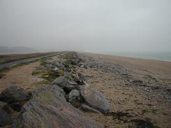
I had been very much looking forward to the walk along Slapton Sands, which I last visited on my degree course in 1993. Unfortunately whilst I was walking along it the weather was vile, which cut short the views and made photography difficult. The whole area was evacuated in 1943 so that it could be used as a staging and practice area for the attacks that were to take place on Utah Beach on D-Day. I passed the memorial given to the area by the US army in thanks for the sacrifice of the locals, and when I got to Torcross I saw the tank. I remember the tank very clearly from my last visit to the area, and it is quite an impressive sight, but not as impressive as the story behind it. During one of the dry runs for the attack on Utah Beach some German E-Boats (torpedo boats) got amongst the convoy of American Landing Ship Tanks and sunk some of them, with the loss of nearly 1.000 lives. The tank was raised from the seabed in 1984 as a result of a campaign run by a local man, Ken Small, to act as a memorial to the men who died. I was lucky enough to meet Ken Small by the tank, and I bought a copy of his book about the story, and I found it a riveting read. Ken Small himself is a quite remarkable man, and I chatted to him for a while, but not as long as I wanted due to the rain that was getting me very wet by this time. The book about the disaster and his campaign to raise the tank from the seabed as a memorial to the men who died is called 'The Forgotten Dead' (ISBN 0-7475-0433-4), and is well worth a read.
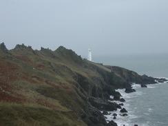
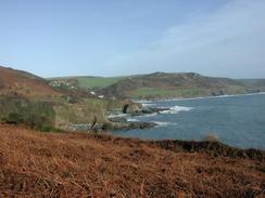
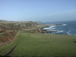
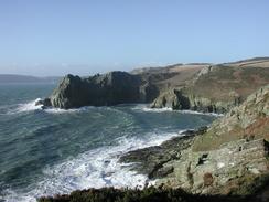
There were some great views available between Start Point and Prawle Point, with some great crags visible from the path. The path is actually relatively level, as it contours around the cliffs rather than climbs up and down them all the time. Despite this it is still a fairly strenuous walk, but the effort expended was well rewarded with the tremendous views. In places it was not obvious where the path was going as it wound around the crags, and this was quite exhilarating. There were danger signs warning people to keep to the path over the worst sections, although I have seen far worse sections of path on this trip. In particular the craggy ridge from Nestley Point towards the lighthouse at Start Point looked absolutely superb in the bright sunshine, a dark, rocky, craggy ridge which clashed brilliantly with the blues of the sky and sea, and the white of the lighthouse.
Prawle Point is the most southerly point in Devon, and from here on I will be going in a general northerly direction until I reach Plymouth and Cornwall. I find it quite amazing to look on a map of the country and see how far I have walked on this trip; I am now such a long way from Edinburgh in a straight line, yet alone the winding route that I have taken. Tomorrow I have another river estuary to walk around, and another two will closely follow this before I reach Plymouth. I am unsure how I feel about these river estuary diversions; sometimes when I think about them I feel like I quite enjoy the variety of the estuary walks when compared with the coastal walks, and at other times I hate them as they are seemingly stopping my further progress.
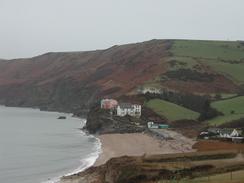
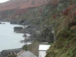
At Hallsands there is an old, ruined village below the cliffs. The village was abandoned in the early years of the twentieth century when dredging of shingle offshore caused the beach level to fall almost overnight and therefore removed the village's protection from the waves. The sea claimed the path down to the village a few years ago, but this has been replaced by a viewing platform that just allows you to see the village. Two of the houses are still occupied, and these contrast with the ruined houses behind them. It is very strange to think that the rocky cliffs and ledges of which the village comprises was once more like the next village to the north, Beesands, but the beach has totally disappeared. It is quite a tragic and moving sight, although it is a shame that you cannot walk amongst the buildins anymore.
There is a regular ferry running between East Portlemouth and Salcombe, so we decided that we would meet up in the larger town as it would be easier to get to. The last ferry leaves at five in the afternoon, so I had to get to the landing stage before then, which I thankfully managed with plenty of time to spare. The trip across the river cost ninety pence and the journey was quick and enjoyable, with some lovely views available over the river estuary. When I got to the other side I met Sam and we went in for a couple of drinks at The Victoria Inn before making our way up the hill to Mervan for the night.
Directions
| During this walk I followed the South West Coast Path, the route of which is detailed in the Ordnance Survey National Trail Guide 10, Falmouth to Exmouth (ISBN 1-854108-90-5). Unfortunately the route description is written in reverse to the direction that I am walking, but the 1:25,000 maps in the book are clear and the signs on the ground are very good. Also to be recommended is the South West Coast Path Association guidebook (ISBN 0-907055-04-4), which has less concise directions and no maps, but includes accommodation details and grades each section of the walk according to difficulty. They also publish reverse directions, which are suitable for walking in the direction that I walked the route. They have a website at www.swcp.org.uk, which is well worth a visit. | 
|
| 
| |
| |
| |
Distances
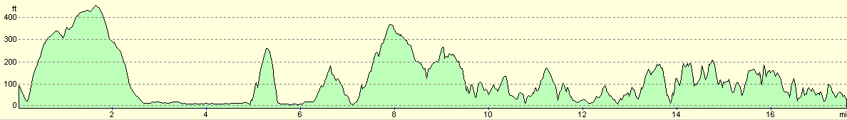
| From | To | Distance (m) | Ascent (ft) | Descent (ft) |
|---|---|---|---|---|
| Blackpool Sands | Start Point | 8.7 | 1434 | 1414 |
| Start Point | East Portlemouth | 9.0 | 2457 | 2549 |
This makes a total distance of 17.7 miles, with 3891 feet of ascent and 3963 feet of descent.
For more information on profiles, ascents and descents, see this page
Accommodation
We parked the van on a residential street just off the A381 in Salcombe, which was an unfortunately long walk uphill from the centre of the town.
Disclaimer
Please note that I take no responsibility for anything that may happen when following these directions. If you intend to follow this route, then please use the relevant maps and check the route out before you go out. As always when walking, use common sense and you should be fine.
If you find any information on any of these routes that is inaccurate, or you wish to add anything, then please email me.
All images on this site are © of the author. Any reproduction, retransmissions, or republication of all or part of any document found on this site is expressly prohibited, unless the author has explicitly granted its prior written consent to so reproduce, retransmit, or republish the material. All other rights reserved.
Although this site includes links providing convenient direct access to other Internet sites, I do not endorse, approve, certify or make warranties or representations as to the accuracy of the information on these sites.
And finally, enjoy your walking!
This walk was mentioned in the following routes:
| My walk around the coastline of Britain |
| South West Coast Path |
Nearby walks
| # | Title | Walk length (miles) |
|---|---|---|
| 324 | Torquay to Coleton Camp | 15.0 |
| 325 | Coleton Camp to Totnes | 15.3 |
| 326 | Totnes to Blackpool Sands | 17.7 |
|
|

|