Walk #328: East Portlemouth to Salcombe
 |
 |
|
General Data
| Date Walked | 16/01/2003 |
| County | Devon |
| Start Location | East Portlemouth |
| End Location | Salcombe |
| Start time | 08.33 |
| End time | 14.34 |
| Distance | 12.7 miles |
| Description | This was a short but nonetheless enjoyable plod along roads around the Kingsbridge Estuary. |
| Pack | Today I carried my 30-litre Karrimor HotRock rucksack, which was filled with my packed lunch, waterproof leggings, water bottle and a couple of spare shirts, together with the usual assortment of odds and ends. |
| Condition | I feel absolutely fine after this walk, which is to be expected as it was such a short distance. I had no problems worth reporting, and everything felt fine at the end of the walk. |
| Weather | Today's weather was gloriously sunny, and this made the river estuary shine a deep blue that was quite enchanting. It was not cold, and there was hardly any wind to annoy me, so I got quite hot even with a thin fleece on. All in all this was a perfect January day for walking. |
| OS map | Landranger number 202 (Torbay & South Dartmoor, Totnes & Salcombe) |
 |
 |
|
 |
 |
|
Map of the walk
Maps courtesy of Google Maps. Route for indicative purposes only, and may have been plotted after the walk. Please let me have comments on what you think of this new format. For a detailed table of timings for this walk, please see the table file.
 |
 |
|
Notes
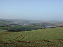
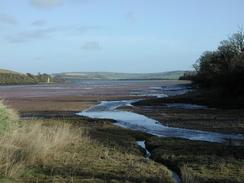
This walk was yet another diversion around a river estuary, which are becoming increasingly common at the moment. This time it was around the Kingsbridge Estuary, and unfortunately the walk was mainly along roads as there were few suitable footpaths in the area. Fortunately all the roads (excepting the A381) were quiet, and the only difficult section of the walk was the walk westwards along the A381 between Frogmore and Kingsbridge, over which I had to exercise some care - a better but less direct route may be available with some thought. In particular there are some looping footpaths that take you south of the road, on a green lane that heads over the hill to the north of the road and is a more direct route, but it is farther away from the river.
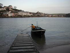
First thing in the morning Sam and I had to walk downhill from where we had parked Mervan to the centre of Salcombe. This was so that I could catch the ferry across to East Portlemouth, from where the walk was due to start. As we waited for the ferry a man turned up with his dog, and apparently he uses the ferry for his daily commute across the river. There were some fine views available from the boat as it made its way across the river, and I enjoyed looking out at the slightly reddened sky as the sun struggled to rise above the hills to the east. It must be a very nice way to have to go to work each day, and sitting in an open boat really beats sitting in a traffic jam in a city, except of course when it rains!
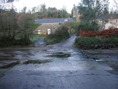
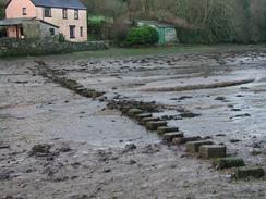
I came across a couple of sets of stepping stones today - the first was at Waterhead, which is to the east of East Portlemouth, where a long set of stepping stones took a footpath across a tidal section of the river. Fortunately when I reached them the tide was low, but unfortunately some of the stones were slippy and others were out of position, so for some of the way across the channel I chose to walk along the riverbed instead of along the stones, which did not matter as the water was under ankle deep in most of the places. The second set of stones was in a very picturesque location in South Pool, where they led across the very end of South Pool Creek. I did not bother crossing these as there was a bridge nearby that took me on a far more direct route, but these stones were in a quite picturesque setting and I could not help but admire them.
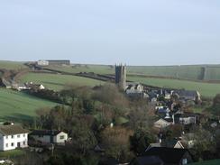
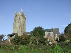
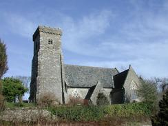
I visited several churches today, and fortunately all of them were unlocked do that I could have a look around. The church of St Nicholas and St Cyric in South Pool was very nice, and the tiered tower was particularly striking. It also has an original Rood Screen that dates from about 1480. I also visited St Mary's Church in West Charleton, which I found less interesting but was still a very nice church, with a castellated tower and a fairly nice sedilia. It is very nice to see churches that are open and are not locked, as I think that it is a great shame when churches have to be locked, as it sort of goes against their whole purpose.
On the walk southwards from Kingsbridge I met a nineteen-year old local man called Edward, who was on a twenty mile run and walk through the area to get fit for a holiday in Europe. We walked together for about half an hour, and talked about the walk and the local area. It was quite refreshing to have someone walk with me on a walk who can walk at a decent pace, even up hills, and I found that his presence was also forcing me to walk faster and not to dawdle, which can only be a good thing. It was a shame that this section of the walk was along roads as there were not many nice views to be head, although the end of the estuary at Batson was fairly picturesque.
I got very annoyed today. When I was at South Pool I had a phone call from Sam, who had been made to cry by a couple of ladies in the road where we had parked the van. They said that we were parked illegally, and that they were going to call the police out to move her on., Sam tried explaining what we were doing, but apparently they still took a very negative tone. There were no yellow lines on the road, there were not any no parking signs, we were not blocking any access roads or driveways, and a couple of other vehicles were parked on the same side nearby. They were mainly complaining about the fact that our van was blocking their view, which in a way I could understand but here no reason to take the sort of attitude they did. Sam was very upset by this, and particularly as we would have been moving the van in a couple of hours anyway. I still believe that we were not parked illegally, and their attitude astounds me - we were not even directly outside their house!
In Kingsbridge I stopped off at the Creek End Inn, at the very end of the estuary. I had a pint of Abbot ale and sat down too read the latest edition of Private Eye, which I had bought from a newsagents in Salcombe earlier in the day. The pub started getting busier after a while, so I went and asked if I could do a collection around the bar. The owner said yes, and everyone was very generous, which is nice. It is amazing how some people can be so generous and helpful, whilst others, like the ladies in Salcombe, can be so negative - I guess that it all depends on the way that you meet people.
Directions
This walk starts of at the ferry landing stage at East Portlemouth, across the Kingsbridge Estuary from Salcombe. Leave the ferry landing stage and head onto the road and turn left. Follow the road as it heads eastwards, crossing two tidal fords before reaching houses on the left near Waterhead. Here a footpath leads down to the left, to a set of stepping-stones across a tidal creek. You will only be able to cross these if the tide is low; otherwise you will have to find an alternative route around to South Pool.
On the north side of the stepping stones take a green lane that heads steeply uphill before it meets a surfaced road end-on. Follow this road as it descends downhill into the little village of South Pool. At the end of the road turn right for a few yards beside South Pool Creek and then follow the road as it crosses an attractive little bridge over the creek. On the other side of the bridge head uphill along the road to the east of North Pool before it descend steeply to cross over the stream at the eastern end of Frogmore Creek before it ends at a T-junction in Frogmore.
From Frogmore turn left along the A379 road. This is far from an ideal route as the road is winding, narrow and fairly busy, which dies not make for a good combination. I would recommend that you take another route, perhaps following a footpath that lops away to the south along he northern bank of Frogmore Creek before ending in West Charleton, or perhaps taking the green lane that leads northwestwards from Frogmore over a hill directly into Kingsbridge. If you do follow the A3379 road, then follow it westwards through East and then West Charleton, before it descends down to cross a creek on a bridge. It then curves around and follows the eastern edge of another creek into the centre of Kingsbridge.
Follow the road through Kingsbridge until the creek ends near the bus station. At the end of the creek turn left and follow a road uphill past a petrol station and then take a road that immediately leads off to the left. This road heads southwards, climbing uphill before descending to pass the end of a little creek. It then climb uphill again and continues in a roughly southerly direction before descending down to meet Collapit Bridge, at the end of another creek. The road then climbs once more before descending steeply down to Blanksmill Bridge, at the end of yet another creek. From here the road continues uphill until a T-junction is met. At the junction turn left and follow the road past Ilton Castle Farm, where there is a campsite, down the hill and into Batson. At a crossroads take a road to the left, which follows the southern edge of a creek past a boatyard and into Salcombe. This walk ends at the ferry landing in the centre of the village.
Distances
| From | To | Distance (m) | Ascent (ft) | Descent (ft) |
|---|---|---|---|---|
| East Portlemouth | Kingsbridge | 8.1 | 1293 | 1302 |
| Kingsbridge | Salcombe | 4.6 | 853 | 833 |
This makes a total distance of miles, with 2146 feet of ascent and 2135 feet of descent.
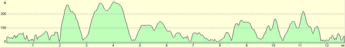
For more information on profiles, ascents and descents, see this page
Accommodation
We stayed at the campsite at Ilton Castle Farm, Malborough, Kingsbridge, TQ7 3DA, which I passed on the walk towards the end of today. This site was a cheap and cheerful campsite that cost us four pounds forty pence for the night. The facilities were reasonable for this price, and the showers cost us twenty pence. They can be contacted on 01548 842379.
Disclaimer
Please note that I take no responsibility for anything that may happen when following these directions. If you intend to follow this route, then please use the relevant maps and check the route out before you go out. As always when walking, use common sense and you should be fine.
If you find any information on any of these routes that is inaccurate, or you wish to add anything, then please email me.
All images on this site are © of the author. Any reproduction, retransmissions, or republication of all or part of any document found on this site is expressly prohibited, unless the author has explicitly granted its prior written consent to so reproduce, retransmit, or republish the material. All other rights reserved.
Although this site includes links providing convenient direct access to other Internet sites, I do not endorse, approve, certify or make warranties or representations as to the accuracy of the information on these sites.
And finally, enjoy your walking!
This walk was mentioned in the following routes:
| My walk around the coastline of Britain |
| South West Coast Path |
Nearby walks
| # | Title | Walk length (miles) |
|---|---|---|
| 326 | Totnes to Blackpool Sands | 17.7 |
| 327 | Blackpool Sands to East Portlemouth | 17.7 |
| 329 | Salcombe to Aveton Gifford | 15.3 |
|
|

|