Walk #329: Salcombe to Aveton Gifford
 |
 |
|
General Data
| Date Walked | 17/01/2003 |
| County | Devon |
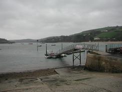
| Start Location | Salcombe |
| End Location | Aveton Gifford |
| Start time | 09.57 |
| End time | 16.28 |
| Distance | 15.3 miles |
| Description | This was a lovely and very scenic walk along the cliffs to Bantham, which was followed by a short walk along footpaths beside the River Avon. |
| Pack | Today I carried my 30-litre Karrimor HotRock rucksack, which was filled with my packed lunch, waterproof leggings, water bottle and a couple of spare shirts, together with the usual assortment of odds and ends. |
| Condition | I feel absolutely fine after this walk, and have no major problems to report. My feet ached slightly for a short period around the middle of the day for some reason, but this soon wore off. |
| Weather | The day started off quite wet, with a light rain that soon had me quite wet. There was a fairly fierce wind to accompany this, and at times this made the walk quite miserable. Fortunately after a few hours the rain started to stop, and in the afternoon the wind lessened and he sun thankfully came out, so I managed to dry out fairly quickly. |
| OS map | Landranger number 202 (Torbay & South Dartmoor, Totnes & Salcombe) |
 |
 |
|
 |
 |
|
Map of the walk
Maps courtesy of Google Maps. Route for indicative purposes only, and may have been plotted after the walk. Please let me have comments on what you think of this new format. For a detailed table of timings for this walk, please see the table file.
 |
 |
|
Notes
I had a very late start today, as I spent some time getting a CD with the latest website update prepared so that it could be sent to Terry for uploading onto the server. This took a long time, and afterwards we had to fill Mervan's water tank up. Unfortunately the water pressure was quite low, and so we were waiting for an age for it to fill up. It felt quite unusual waking up in a field full of sheep - Sam and I took great joy watching them run about the field, and we are both firmly convinced that they are incredibly stupid animals. Actually the late start has done me some good and I was in a very good mood this morning, the sort of mood that even the wet weather could not dampen.
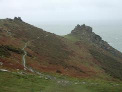
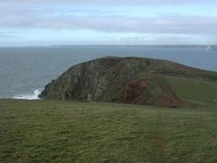
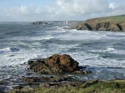
Some of the cliffs today were fantastic, in particular those to the north of Bolt Head that were very craggy and rocky. The walk along this section was a massive pleasure, even in the wet and windy weather. Past Bolt Head the path became flatter with only a couple of steep ascents and descents as it crosses Bolberry Down, and this was a very pleasant walk once the sun had come our. Unfortunately it was wet during the most spectacular section of the walk, and so the views were foreshortened and the photographs will not be as good as if it had been sunny at that time, but this should be compensated for by the good weather later on in the walk from Bolt Tail onwards. It seems that at the moment the weather is either very cold but sunny, or milder with prolonged rain and sunny periods - I am not sure which of those options I prefer, but I think it is the cold and dry one, as at least with that I can wrap up warmer.
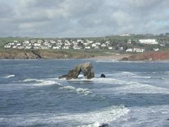
Some of the villages on this walk were very pretty, in particularly Outer and Inner Hope, which wee backed by a gloriously blue sea and red cliffs with a sea arch out at sea, which made a magnificent view for me as I sat and ate my sandwiches. I generally like these little seaside villages far more than the towns or cities as the villages are generally uncommercialised and quiet, which was most certainly the case in Outer Hope, where workmen digging a trench were generating the only noise. Unfortunately there was a fierce, cold breeze at the time and the bench on which I was sitting was quite exposed to the wind, so I did not sit as long as I wanted as I needed to get out of the cold and to warm myself up by walking again.
This evening Sam and I went to the local pub, The Fishermen's Rest, for a drink, and we ended up staying there for a couple of hours. The landlord was kind enough to allow us to do a collection for the charity, and this raised quite a nice amount from the drinkers in the bar. It is nice to see people being kind after the trouble Sam had yesterday and it restored our faith in human nature. The pub itself was very nice, a classic country pub that has diversified slightly. Unfortunately the local shop and post office are going to close shortly as they cannot afford their overheads, and the local community will lose another very useful service. One of the things that I am noticing as I am doing this walk is the way that the heart is being ripped out of many communities as shops, post offices and pubs shut, and rural bus services are slashed - and the people who lose out the most are the elderly and those without private transport.
Tomorrow I will have another one or two estuaries to walk around - I have to complete the walk down the Avon estuary, and then walk the short distance to the Erme Eestary. If possible I will ford this, an if not I will have to walk around it. After this there is another walk don to the Yealm estuary, but because of the uncertainty of how I am going to cross the Erme I am unsure about whether I am going to get that far. To add some more uncertainty into the equation, the first section of the road south from Aveton Gifford is tidal, so if the tide is high I may have to make a diversion to get around that section of road.
Directions
| During this walk I followed the South West Coast Path, the route of which is detailed in the Ordnance Survey National Trail Guide 10, Falmouth to Exmouth (ISBN 1-854108-90-5). Unfortunately the route description is written in reverse to the direction that I am walking, but the 1:25,000 maps in the book are clear and the signs on the ground are very good. Also to be recommended is the South West Coast Path Association guidebook (ISBN 0-907055-04-4), which has less concise directions and no maps, but includes accommodation details and grades each section of the walk according to difficulty. They also publish reverse directions, which are suitable for walking in the direction that I walked the route. They have a website at www.swcp.org.uk, which is well worth a visit. | 
|
| 
| |
| |
| |
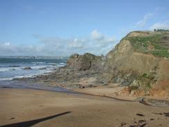
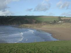
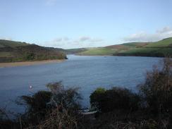
The second part of the walk is from Bantham to Aveton Gifford, which I walked by following the Avon Eestuary Trail. This walk is very well waymarked and the route is detailed in the South West Coast Path Association guidebook, so I will not replicate the directions here. The walk ends at the car park beside the roundabout in Aveton Gifford, on the western side of the river.
Distances
| From | To | Distance (m) | Ascent (ft) | Descent (ft) |
|---|---|---|---|---|
| Salcombe | Bolt Tail | 7.3 | 2136 | 1982 |
| Bolt Tail | Bantham | 4.9 | 807 | 965 |
| Bantham | Aveton Gifford | 3.1 | 531 | 558 |
This makes a total distance of 15.3 miles, with 3474 feet of ascent and 3505 feet of descent.
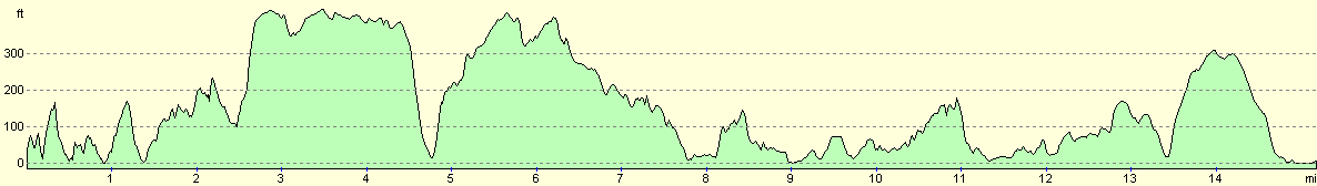
For more information on profiles, ascents and descents, see this page
Accommodation
We parked in car park in Aveton Gifford, which was free and very close to a pub. This was quite handy, and was right on my route so I did not have to walk any further through the village.
Disclaimer
Please note that I take no responsibility for anything that may happen when following these directions. If you intend to follow this route, then please use the relevant maps and check the route out before you go out. As always when walking, use common sense and you should be fine.
If you find any information on any of these routes that is inaccurate, or you wish to add anything, then please email me.
All images on this site are © of the author. Any reproduction, retransmissions, or republication of all or part of any document found on this site is expressly prohibited, unless the author has explicitly granted its prior written consent to so reproduce, retransmit, or republish the material. All other rights reserved.
Although this site includes links providing convenient direct access to other Internet sites, I do not endorse, approve, certify or make warranties or representations as to the accuracy of the information on these sites.
And finally, enjoy your walking!
This walk was mentioned in the following routes:
| My walk around the coastline of Britain |
| South West Coast Path |
Nearby walks
| # | Title | Walk length (miles) |
|---|---|---|
| 327 | Blackpool Sands to East Portlemouth | 17.7 |
| 328 | East Portlemouth to Salcombe | 12.7 |
|
|

|