Walk #374: Summerhouse Point to Merthyr Mawr
 |
 |
|
General Data
| Date Walked | 05/03/2003 |
| County | South Glamorgan, Mid Glamorgan |
| Start Location | Summerhouse Point |
| End Location | Merthyr Mawr |
| Start time | 09.42 |
| End time | 16.24 |
| Distance | 14.5 miles |
| Description | This was a long walk along cliffs that should have offered good views, but unfortunately low cloud prevented this, which was annoying. |
| Pack | Today I carried my 30-litre Karrimor HotRock rucksack, which was filled with my packed lunch, waterproof leggings, water bottle and a couple of spare shirts, together with the usual assortment of odds and ends. |
| Condition | I feel absolutely fine, if somewhat drenched, after this walk and have no problems to report. |
| Weather | The weather today was absolutely awful, with continuous rail all the way until I got to Ogmore-by-Sea. The rain eventually stopped, so I restarted the walk and continued on under cloudy skies. Fortunately there was not much wind, so although I got wet I did not get cold at the same time. |
| OS map | Landranger number 170 (Vale of Glamorgan, Rhondda & Porthcawl) |
 |
 |
|
 |
Map of the walk
Maps courtesy of Google Maps. Route for indicative purposes only, and may have been plotted after the walk. Please let me have comments on what you think of this new format. For a detailed table of timings for this walk, please see the table file.
Notes
I took yesterday off, as the weather forecast had been for heavy rain yesterday and sunshine today, and I had some work that could be done whilst we were at a good campsite. Unfortunately, and as I could have guessed, yesterday was dry and sometimes even sunny, and today was very wet. I am not that bothered about this, however, as I had a nice day off and got the work done that I have been wanting to do for ages. We went into Llanwit Major for lunch and to get access to the Internet before having a drink and going back to the campsite and playing a couple of games of snooker on a full-size snooker table. This was all good fun, and helped me recharge my batteries.
The work also went quite well, although it was quite stressful. I have one main script on my computer that generates my website, and as I am taking lots of photographs this was taking over forty-five minutes to run. I have to run this script several times to generate the site, and so this involves much waiting around for it to complete. This situation was just going to get worse as time went on, and so I decided to rewrite the script to get around the problems. Eventually this morning I got the script so that it takes only eight minutes, which is a vast improvement.
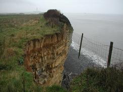
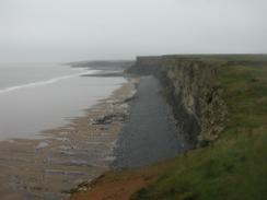
Today was surprisingly hillier than I had expected. The last few days have been relatively flat, with few hills or other significant climbs. This was very different, with some high cliffs and steep ascents and descents. To make matters worse, the path was exceedingly muddy throughout the route and made going very hard - I slipped over once and got mud all over my backside and pack for my trouble. In one place the path had disappeared over the edge of the cliff on a particularly steep descent, and so I had to divert inland slightly down an even steeper route. The mud was relatively easy to cope with, but when it was combined with the rain and footpaths converted into streams then it was much trickier and far from enjoyable. I was very glad that I had my walking poles, and if it were not for these then I may have had to divert inland around the steepest sections of path as they would have been dangerous without them.
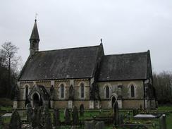
By the time that I reached Ogmore-by-Sea I was totally soaked and feeling very, very depressed. Sam was waiting for me in the car park and I got into Mervan and undressed, stripping off clothes that started steaming as soon as they hit the floor. Half an hour after I stopped the rain also eased, and so I decided to walk further as it had been a short day. I was very unsure about where I was going to be able to cross the Ogmore River, and so I decided that it was best to continue on and cross the river today. I passed the ruins of Ogmore Castle and progressed a little further on to where a bridge crosses a tributary of the river before a swing bridge crossed the main river a short walk away. Later I learnt that there are stepping-stones across the river by the castle, but due to the rain these were well under water this afternoon. I eventually ended the walk in Merthyr Mawr, a lovely little village with a cute church that I enjoyed walking around whilst I waited for Sam to arrive.
This evening we went to visit a Riding for the Disabled Group in Coity, to the northeast of Bridgend. This was a highly enjoyable evening, and we had a long chat to the owners of the group whilst the youngsters were on the ponies. Yet again this reminded me of why I chose this charity to raise money for on this walk, and all the children appeared to love the experience.
On the latter part of today's journey I passed a pub on the B4524 called the 'The Pelican in her piety', which is probably the strangest name for a pub that I have seen so far on this walk. I found this name incredibly intriguing, so we went back into the pub this evening so we could find out more (that was my excuse, at least). Unfortunately although we found out what the symbol meant, we could not find out why the symbol and name were associated with the pub. It is a very nice pub inside, and we enjoyed spending a pleasant hour inside.
As I have done a shorter walk today than I had been expecting (I had wanted to get to Porthcawl) I am having to replan my route for tomorrow accordingly. I shall certainly reach Port Talbot, and the only question is how much further than that I get. I am quite keen to get a long walk done, as I did a shorter one yesterday and took the previous day off.
Directions
This walk starts off from the car park at Summerhouse Point, to the southeast of the town of Llanwit Major. Leave the car park and head down a path through trees to the coast, passing the ruins of a strange octagonal building on the way. One the cliff top is reached turn to the right and follow a path westwards along the top of the cliffs. The path emerges from the trees near the Seawatch Centre (housed in an old H.M. Coastguard lookout station) and follows the path along the cliffs.
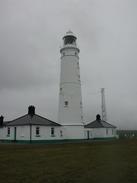
The path continues westwards for over two miles to the car park at Col-huw Point, and climbs up from here before descending into Tresilian and then St Donat's Bay. A mile further west the path passes underneath the lighthouse at Nash Point before reaching he old lighthouse, where the path turns to the right to head northwestwards, joining a surfaced track to a car park.
At the car park a path descends down into a little valley before climbing up to rejoin the top of the cliff on the northern side of the valley. The path then continues northwards, descending into the valley at Cwm Nash before ascending steeply up the other side. Although there is no public footpath marked on the map this stretch is part of the Glamorgan Heritage Coast path, and there is a path on the ground that follows the cliff top.
The path descends into another little valley above Traeth Bach before climbing up and immediately descending steeply into Cwm Mawr. The path climbs out of this valley and ascends for a short distance before descending to a surface path at Dunraven Park. Head north from here to join a surfaced road until it reaches a car park.
Leave the car park and head uphill along the road until it bends to the right at the top of the hill, at which point a bridleway leads off along the cliff top. Follow this until it meets the B4524 road and walk along this road for a short distance until a path leads off to the left. This path heads around the seaward side of Ogmore-by-Sea until it reaches a car park beside the southern bank of the Ogmore River.
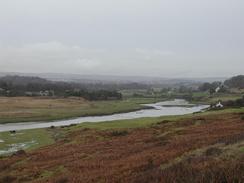
Leave the car park and join the B4524 road as it heads eastwards along the southern bank of the river until the ruins of Ogmore Castle is reached. At the castle a long string of stepping-stones lead over the river to the swing bridge mentioned below, but if these are impassable then continue along the road until a little concrete bridge is reached on the left over the Ewenny River.
Cross the bridge and then head along a path northwestwards to a swing bridge over the Ogmore River. On the other side of the river pass through the car park and along the road to a T-junction. At this junction turn left for a hundred yards, and Merthyr Mawr Church is on the right.
Distances
| From | To | Distance (m) | Ascent (ft) | Descent (ft) |
|---|---|---|---|---|
| Summerhouse Point | Nash Point | 5.7 | 1289 | 1319 |
| Nash Point | Merthyr Mawr | 8.8 | 2362 | 2398 |
This makes a total distance of 14.5 miles, with 3651 feet of ascent and 3717 feet of descent.
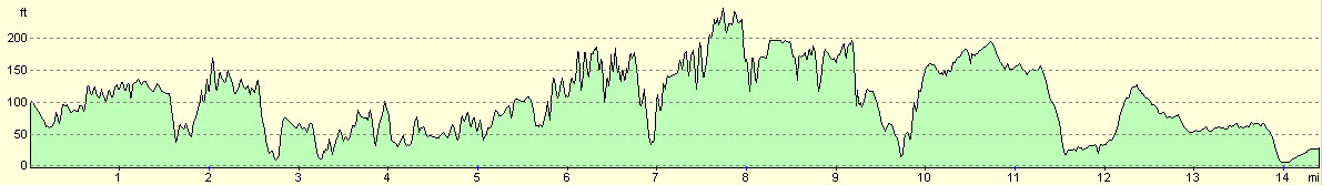
For more information on profiles, ascents and descents, see this page
Accommodation
The landlord of the 'The Pelican in her piety' pub allowed us to stay in their car park, which was very kind of him, and this meant that we could use the pubs facilities.
Disclaimer
Please note that I take no responsibility for anything that may happen when following these directions. If you intend to follow this route, then please use the relevant maps and check the route out before you go out. As always when walking, use common sense and you should be fine.
If you find any information on any of these routes that is inaccurate, or you wish to add anything, then please email me.
All images on this site are © of the author. Any reproduction, retransmissions, or republication of all or part of any document found on this site is expressly prohibited, unless the author has explicitly granted its prior written consent to so reproduce, retransmit, or republish the material. All other rights reserved.
Although this site includes links providing convenient direct access to other Internet sites, I do not endorse, approve, certify or make warranties or representations as to the accuracy of the information on these sites.
And finally, enjoy your walking!
This walk was mentioned in the following routes:
| My walk around the coastline of Britain |
Nearby walks
| # | Title | Walk length (miles) |
|---|---|---|
| 373 | Lavernock Point to Summerhouse Point | 15.3 |
|
|

|