Walk #373: Lavernock Point to Summerhouse Point
 |
 |
|
General Data
| Date Walked | 03/03/2003 |
| County | South Glamorgan |
| Start Location | Lavernock Point |
| End Location | Summerhouse Point |
| Start time | 08.57 |
| End time | 17.13 |
| Distance | 15.3 miles |
| Description | This was not the best walk in the world, and the bit that could have been nice was spoilt by the rain. |
| Pack | Today I carried my 30-litre Karrimor HotRock rucksack, which was filled with my packed lunch, waterproof leggings, water bottle and a couple of spare shirts, together with the usual assortment of odds and ends. |
| Condition | I feel fine after this walk, except for the fact that for the last few miles I was bitterly cold and numb from the joint effects of the wind and rain. |
| Weather | The morning started off cloudy with a slight breeze, and so it remained until after lunchtime, when it started to rain. It never rained heavily, but it did not need to, as it was continuous. Within an hour I was soaked, and the combination of the wind and rain chilled me to the core. All in all it was a dramatically different - and worse - day to yesterday. |
| OS map | Landranger number 170 (Vale of Glamorgan, Rhondda & Porthcawl) and Landranger number 171 (Cardiff & Newport, Pontypool) |
 |
 |
|
 |
 |
|
Map of the walk
Maps courtesy of Google Maps. Route for indicative purposes only, and may have been plotted after the walk. Please let me have comments on what you think of this new format. For a detailed table of timings for this walk, please see the table file.
Notes
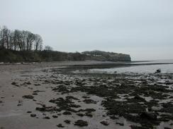
I had been expecting the section of the path to Barry to be quite easy going, but unfortunately I was wrong. The map shoes a footpath clearly heading along the coast at St Mary's Well Bay. I found this footpath easy enough to follow, but there is a place where it squeezes between the cliff edge and a caravan park, and halfway along this stretch I found that the path and slumped onto the beach below, leaving the path impassable. I considered using the fence as a support to make my way across the twelve-foot gap, but I decided that this was too risky. Instead I had to backtrack and make my way down the cliff onto the beach (which unfortunately had to be done by a sewage outlet and over rocks that were smelly, slimy and slippy), and walk along the beach to the western side of the bay, where I climbed back up onto the cliffs by an old ruined house. There was no footpath closure notice warning that the pat was dangerous, and although there was a barrier this was well off the path so I was unaware that it related to the footpath. This is all highly annoying, especially as the alternative route that I took would be impassable at high tides.
I have always associated Barry with what friends of mine call the 'Barry phenomenon' - the fact that two hundred steam locomotives have been saved because they were kept rusting away in a scrapyard in the town. Dai Woodham owned the scrapyard when British Railways were modernising in the sixties, and his scrapyard filled up with steam locomotives awaiting the cutting torch. Unlike many scrap yards around the country, however, Dai concentrated on cutting up thousands of wagons and left the locomotives for last, and by the early seventies Barry was a Mecca for the steam enthusiast. Slowly the yard began to empty of locomotives, gone not for scrap but to be restored, and many are now running on reserved lines, or even the main line. As a child I remember seeing children playing on the rusting hulks of locomotives on TV, and I wonder how many of those locomotives are now in steam. The last locomotive left the yard in the early nineties, and the yard has been developed leaving little trace of the reason why the small town of Barry became famous to many throughout the land. Friends of mine are busy restoring one of these 'Barry hulks' - an 8F, and I can hardly wait to se it steam after many years of restoration from what was a rusting pile of metal.
Rhoose Point is the southernmost point in mainland Wales, a fact that a sign proudly told me. It must be a close-run thing, however, as Breaksea Point a few miles west seems to be nearly as far south. I could not help but think back to when I was at Lizard Point in Cornwall, the southernmost point on mainland Britain, and think how far I have travelled since then.
Walking past Aberthaw power station was interesting, if only for the fact that it had been the first distinguishable bit of Wales that I had seen from the north coast of Somerset. It is nice to think that I have rounded the corner that is the mouth of the Severn, and I do not have that far to walk until I reach the part of Wales that I am most looking forward to - the Pembrokeshire Coast Path.
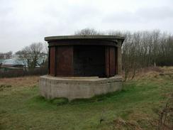
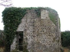
By the time I reached Summerhouse Point I was feeling very tired, cold and wet, and so I called Sam and told her that I was finishing the walk early. This was undoubtedly the right thing to do, as by that time I was so cold that my fingers had gone numb and my bottom was well and truly soaked. I could have continued on to Col-huw Point, to the southwest of Llanwit Major, where Sam was due to pick me up, but I decided that the extra couple of miles were not worth risking getting a cold for. This also led me to an interesting find; at Summerhouse Point there are the remains of an old fort that is marked on the map. I would not have visited this if it I had not been heading inland to reach the car park. I am intrigued by this structure, as it appear to have an octagonal building inside the outer walls, and I cannot recall having seen this design before.
When Sam picked me up I went into the back of the van and stripped out of all my wet clothes. I was shivering by this stage, and I was glad to put on some dry and warm clothes. We reached the campsite quite quickly as it was a short distance down the road and I sat in front of the fan heater to try and warm myself up, and because of this I got pins and needles in my fingers. I have decided to take tomorrow up, so I can catch up with the write-ups of the walks that I have done in the last fortnight, and so that I can do some much-needed work on the scripts that generate the website. I am loathed to take a day off, but tomorrow is forecast to be wet once again, and I really do not fancy getting another soaking.
Directions
This walk starts off beside the church at Lavernock Point, which is to the south of Penarth. From the church head west along the road past a caravan park, and immediately past the park a footpath leads off to the left, and heads southwestward back to the coast, passing some old second world war defences before reaching St Mary's Well Bay.
On the map there is a footpath along the top of the cliffs of the bay. This has eroded away in part so I had to descend down onto the beach and walk across it to the western end of the bay, where I climbed back up at a ruined house and joined a road. I followed this road westwards into Swanbridge, and shortly after it curved away from the sea I took a footpath that headed off to the left after a caravan park.
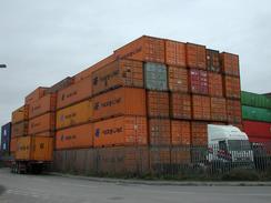
This footpath continues on westwards along Sully Bay, passing Hayes Point and Sully Hospital before reaching a much more industrial area to the east of the docks. When the path skirts a road join it and then turn right and follow it around into the Atlantic Trading Estate.
There is a maze of roads in the estate, but I walked north to a roundabout beside a cafe, where I entered the docks area. There I a big sign stating no entry, but I passed through. Head north along Wimbourne Road, and when it ends at Atlantic Way turn right along the road and follow it as it curves around the end of a dock. Pass the end of a dock and continue on until the road ends at a T-junction to the south of a railway line.
Turn left along this road and follow it southwestwards until Barry Docks Station is reached. At the station an underpass allows access under the railway line and up onto Dock View Road, on the northern side of the line. From here I walked into the centre of Barry with Sam; if you do not want to do this then turn left down Dock View Road and follow it westwards to a roundabout with the A4055 road.
At the roundabout follow the A4055 Broad Street southwestwards as it skirts to the north of the railway line. Shortly after it passes Barry Station it becomes Harbour Road, and shortly afterwards Park Avenue. Continue on down Romilly Park Road before turning left down Lakeside, which passes under the railway line before turning right down Bron-y-Mor, and then turning right up Heol-y-Mor.
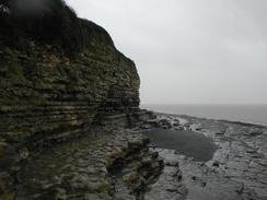
When this road ends at a T-junction continue straight on along a path that heads uphill and joins the top of the cliffs above The Knap. The footpath continues on along the top of the cliffs before descending down into a little valley near Porthkerry. Walk alongside the beach before ascending up once more onto the top of the cliff. Follow the path to Rhoose Point (the southernmost point in South Wales) before continuing on past Ffontygain Bay.
Shortly after this the path heads inland along the cliffs; when it does this descend down the cliffs onto the floodplain underneath and take a path that heads westwards beside the sea wall. The path approaches the power station, where a bridge carries it over a large stream and an official right of way begins.
Follow this footpath to Breaksea Point, where it turns to the right past the power station and continues on westwards to Summerhouse Point. As the path start to rise up onto the cliffs turn right through some trees along another footpath that heads past the ruins of a strange octagonal building and reaches a car park, where this walk ends.
Distances
| From | To | Distance (m) | Ascent (ft) | Descent (ft) |
|---|---|---|---|---|
| Lavernock Point | Barry Station | 7.2 | 436 | 436 |
| Barry Station | Summerhouse Point | 8.1 | 922 | 876 |
This makes a total distance of 15.3 miles, with 1358 feet of ascent and 1312 feet of descent.
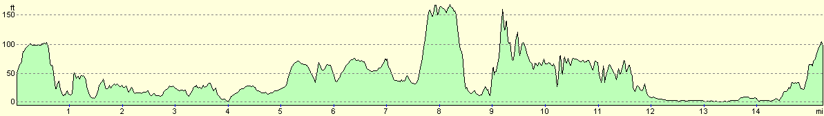
For more information on profiles, ascents and descents, see this page
Accommodation
We stayed at the Acorn Camping and Caravan Site, Rosedew Farm, Ham Lane South, Llanwit Major, Vale of Glamorgan CF61 1RP, who can be contacted on (01446) 794024. This site cost us nine pounds fifty per night, and we spent two nights at this site. The site had some lovely facilities, including a games room and a full-size snooker table, and we were made to feel very welcome.
Disclaimer
Please note that I take no responsibility for anything that may happen when following these directions. If you intend to follow this route, then please use the relevant maps and check the route out before you go out. As always when walking, use common sense and you should be fine.
If you find any information on any of these routes that is inaccurate, or you wish to add anything, then please email me.
All images on this site are © of the author. Any reproduction, retransmissions, or republication of all or part of any document found on this site is expressly prohibited, unless the author has explicitly granted its prior written consent to so reproduce, retransmit, or republish the material. All other rights reserved.
Although this site includes links providing convenient direct access to other Internet sites, I do not endorse, approve, certify or make warranties or representations as to the accuracy of the information on these sites.
And finally, enjoy your walking!
This walk was mentioned in the following routes:
| My walk around the coastline of Britain |
Nearby walks
| # | Title | Walk length (miles) |
|---|---|---|
| 372 | St Brides Wentlooge to Lavernock Point | 18.0 |
| 374 | Summerhouse Point to Merthyr Mawr | 14.5 |
|
|

|