Walk #372: St Brides Wentlooge to Lavernock Point
 |
 |
|
General Data
| Date Walked | 02/03/2003 |
| County | Gwent, South Glamorgan |
| Start Location | St Brides Wentlooge |
| End Location | Lavernock Point |
| Start time | 08.57 |
| End time | 17.13 |
| Distance | 18.0 miles |
| Description | This was a highly enjoyable walk, which took me through the centre of Cardiff. |
| Pack | Today I carried my 30-litre Karrimor HotRock rucksack, which was filled with my packed lunch, waterproof leggings, water bottle and a couple of spare shirts, together with the usual assortment of odds and ends. |
| Condition | I feel absolutely fine after this walk, and I have no significant problems to report. My feet were fine again today, and I do not seem to have suffered too badly from the blisters that I got a few days ago. |
| Weather | Today was the best day for some time, with some lovely views available due to the bright sunshine and clear skies. There were some clouds about, but these were few and quite scattered, and there was some wind accompanying the sunshine, but when sheltered from this wind it actually got quite warm. |
| OS map | Landranger number 171 (Cardiff & Newport, Pontypool) |
 |
 |
|
 |
 |
|
Map of the walk
Maps courtesy of Google Maps. Route for indicative purposes only, and may have been plotted after the walk. Please let me have comments on what you think of this new format. For a detailed table of timings for this walk, please see the table file.
 |
 |
|
 |
Notes
Today started off exceedingly well, as we got a phone call early this morning from my brother to tell me that his wife, Sam, had given birth to Emily Margaret. Both mother and daughter are fine, and Oliver seems ecstatic but tired - Sam went into labour at nine last night and Emily was born at about four this morning, so he did not get much sleep last night. This is great news, and it put me into a great mood that lasted all day.
The eastern entry to the city was via a path beside a little creek, and this was wound around a large tip. The path followed the top of the flood bank, but it was exceedingly muddy and wet underfoot and was far from a nice walk due to the close proximity of the tip. This was followed by a long road walk part of which passed a steel works, and I quite enjoyed looking through the fence into the works as I walked past.
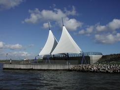
The Worthington Cup Final was taking place today at the Cardiff Millennium Stadium between Liverpool and Manchester United, so as I walked through the city I saw many cars with red flags flying out of them. The streets were also filled with people wearing red shirts, all making their way towards the impressive stadium building. I discovered that I could not walk through the docks, and so I had to make a big diversion into the city centre. It is important to note that whilst the Ordnance Survey Map shows a cycle path going over the Cardiff Bay Barrage this path is not yet connected up at the eastern (docks) end, although it should be in a couple of years. This will be a much better route through the city than the one that I had to walk.
I met Sam outside the Welsh National Assembly, and I posed for a few photographs to be taken of me outside the building. We then walked the short distance to the waterfront, and we went into the Harry Ramsdens for some fish and chips. We sat outside and chatted as we ate these, and whilst they were nice they were not as good as I had been led to expect. After this came the absolute highlight of the day. When we had been in the pub in Redwick a couple of nights ago we met a nice gent called Steve Woodward, who runs a firm that runs cruises out of Cardiff Bay. He had offered us a free trip, and after we had finished our meal we took him up on his kind offer. We thus found ourselves on the mv 'Canberra Queen' on a lovely half-hour trip around the bay, which I can highly recommend. The Canberra Queen used to be the P&O Liner Canberra's number 24 lifeboat, and this added a certain extra attraction to the trip. Cardiff Bay Crusies have a website at www.cardiffbaycruises.com, and I would like to thank them for their kindness.
On the trip I saw lots of interesting things, although I must admit I am not totally at ease on boats and it took me a couple of minutes to forget that I was on one. The Cardiff Bay Barrage was the most obvious item of interest, having been completed a few years ago. I also enjoyed watching yachts racing around the bay, their Spinnaker sails filled with wind and the boats virtually on their sides as they turned. Also in one of the graving docks was a replica of Captain Cook's Endeavour, just reaching the completion of a minor refit. I find it amazing that a ship of such a small size could manage the long journey to Australia, and it is a tribute to all the people who travelled the oceans in those days.
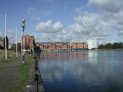
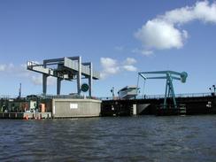
The barrage is a massive construction, and as I walked past it I diverted to have a look a it. The three locks are massive, and whilst I was there the drawbridge above the middle lock opened for a boat to enter the harbour. The locks are absolutely massive - apparently earlier today just one lock had held five boats within it. I found the whole thing absolutely fascinating, and could have spent an age looking around it. The barrage and the resultant fresh water lake has revitalised the Cardiff waterfront, and new buildings are springing up everywhere taking advantage of the waterfront instead of what existed before, which someone described to me as 'stinking mudflats'.
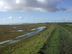
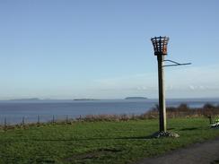
I met Sam by the pier in Penarth, which is a lovely structure but the entrance building needs painting - it does not look well cared for. It felt as though half of South Wales was on the sea front in Penarth, and I enjoyed walking with Sam through crowds instead of on my own in the middle of nowhere. As the sun was still shining and I felt fit, I decided to walk on further, as far as Lavernock Point. The views from the cliffs as I walked southwards were superb - Flat and Steep Holme were visible in detail, and Weston-Super-Mare and Sand Point were visible behind them. Indeed the whole English bank of the Severn was quite visible a vast difference to the hazy skies that I had had in England. I was amazed to discover that to the northeast I could even see the Severn Bridge, the two towers being fairly visible and I could also just make out the approach viaduct to the east. I met Sam at Lavernock Point, and found that she had parked the van in the car park near the church. In the church is a plaque commemorating the first radio transmission over water - made from Flat Holme to Lavernock by Marconi.
Directions
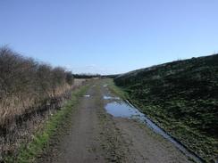
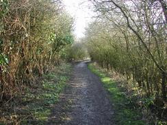
This walk starts off at the pub in St Brides Wentlooge. Leave the pub and turn left to join the B4239 road eastwards for a few yards until a footpath leads off to the right. Follow this footpath southeastwards across two fields until it ends at a track, and then turn right to head southwards down this track as it passes to the right of a caravan park and reaches the flood bank beside the Severn. Climb up to the top of the flood bank and follow it southwestwards. There is no footpath marked on the map, but each fence crossing the bank has a stile in it, so it is obviously used as an undedicated one.
The path continues southwestwards, passing an inlet at Peterstone Gout before continuing on past Peterstone Great Wharf and then Rumney Great Wharf. The bank passes a trig point before curving to the right to start heading along the eastern banks of the Rhymney River, with a tip on the right. The path starts to become very muddy as it passes under some power lines before eventually ending at a road called Lamby Way.
Turn left down this road to cross the river on a bridge until it ends after a couple of hundred yards at a roundabout. At this roundabout turn left to head southeast along the western bank of the Rhymney River along Rover Way. This road does not have a pavement, but the verge is wide enough to walk down in relative safety.
Rover Way curves around to the right to head southwestwards. When Seawall Road comes in from the right a pavement begins on the right hand side of the road. The road passes a steel works and continues straight over two roundabouts before it climbs up to another roundabout. At this roundabout turn right to climb over a railway line along Ocean Way. This road curves around before ending at a roundabout with Tyndall Street, with a large sculpture in the middle of the roundabout. Turn left down Tyndall Street for a few hundred yards until a roundabout is reached.
Continue over this roundabout and pass under a large road bridge and then turn left down Schooner Way. This skirts the attractive Atlantic Wharf before curving away from the water and ending at Hemingway Road. Turn right down this road for a few yards and then turn left down Bute Street before following the signs for the Welsh National Assembly.
Leave the assembly and then follow the riverfront around towards the pier head and the graving docks, which is a lovely area. Leave the docks and walk past the front of the National Tehniquest building and walk up the approach ramps to the A232 Butetown Link. The ramps join the A232 and a cycle path runs alongside the road as it crosses the River Taff on a bridge, and once the other bank is reached descend down the slip roads and turn left along the A4055 Cogan Spur, which crosses the Ely River on a bridge before ending at a roundabout.
At the roundabout turn to the left down Windsor Road and then take the first road to the left that head over a railway line before descending to meet the southern bank of the river. At a roundabout continue straight on past some smart new houses and continue on eastwards past the Portway Marina.
Pass the marina and head around the northernmost road that ends at the lock gates over the entrance to the marina. Cross the lock gates to the customs house and the southern end of the barrage before climbing uphill to the right up Penarth Portway Road. When this road splits continue to the left along Pagets Place that becomes St Augustine's Road.
Turn left down St Augustine's Crescent, which in turn becomes Clive Place and then left down Church Lane, which ends at Beach Road. Turn left and descend down Beach Road until the riverfront and pier in Penarth are met. Continue on along the esplanade and then as it climbs uphill. When the road turns to the right away from the cliff top continue straight on down a surfaced path southwards. The path becomes unsurfaced before it eventually reaches the road and car park at Lavernock Point, where this walk ends.
Distances
| From | To | Distance (m) | Ascent (ft) | Descent (ft) |
|---|---|---|---|---|
| St Brides Wentlooge | Cardiff Bay | 12.3 | 190 | 203 |
| Cardiff Bay | Lavernock | 5.7 | 591 | 545 |
This makes a total distance of 18.0 miles, with 781 feet of ascent and 748 feet of descent.
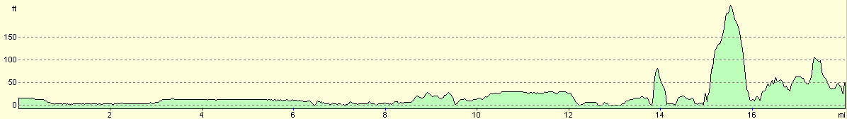
For more information on profiles, ascents and descents, see this page
Accommodation
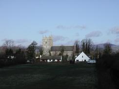
We spent the night in Mervan in the car park in Lavernock, a few yards up the road from the little church. This was a nice and quiet place to spend the night, although there were no facilities nearby.
Disclaimer
Please note that I take no responsibility for anything that may happen when following these directions. If you intend to follow this route, then please use the relevant maps and check the route out before you go out. As always when walking, use common sense and you should be fine.
If you find any information on any of these routes that is inaccurate, or you wish to add anything, then please email me.
All images on this site are © of the author. Any reproduction, retransmissions, or republication of all or part of any document found on this site is expressly prohibited, unless the author has explicitly granted its prior written consent to so reproduce, retransmit, or republish the material. All other rights reserved.
Although this site includes links providing convenient direct access to other Internet sites, I do not endorse, approve, certify or make warranties or representations as to the accuracy of the information on these sites.
And finally, enjoy your walking!
This walk was mentioned in the following routes:
| My walk around the coastline of Britain |
Nearby walks
| # | Title | Walk length (miles) |
|---|---|---|
| 371 | Redwick to St Brides Wentlooge | 18.7 |
| 373 | Lavernock Point to Summerhouse Point | 15.3 |
|
|

|