Walk #371: Redwick to St Brides Wentlooge
 |
 |
|
General Data
| Date Walked | 01/03/2003 |
| County | Gwent |
| Start Location | Redwick |
| End Location | St Brides Wentlooge |
| Start time | 09.00 |
| End time | 16.05 |
| Distance | 18.7 miles |
| Description | This was quite an enjoyable walk, passing through the middle of the town of Newport. |
| Pack | Today I carried my 30-litre Karrimor HotRock rucksack, which was filled with my packed lunch, waterproof leggings, water bottle and a couple of spare shirts, together with the usual assortment of odds and ends. |
| Condition | I feel absolutely fine, if somewhat drenched, after this walk. My feet were fine again today, although I did change into my trainers for the last five miles. |
| Weather | I delayed the start of the walk to allow a band of showers to pass through, and this meant that the morning was a mixture of sunshine and cloud, the former allowing me to dry out all of the clothes that were still damp from yesterday. Unfortunately after my lunch it started to rain, and he end of the walk was followed by an hour of the heaviest rain that I can remember having on this walk. |
| OS map | Landranger number 171 (Cardiff & Newport, Pontypool) |
 |
 |
|
 |
 |
|
Map of the walk
Maps courtesy of Google Maps. Route for indicative purposes only, and may have been plotted after the walk. Please let me have comments on what you think of this new format. For a detailed table of timings for this walk, please see the table file.
Notes
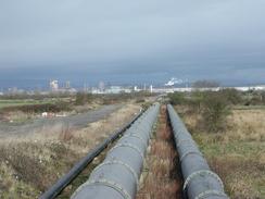
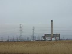
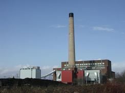
The initial stretch of this walk to Uskmouth was fairly boring and was a case of simply following the flood banking westwards, except for one little diversion inland at Goldcliff. There was not a great deal to see along this stretch except for the Uskmouth power station slowly getting larger and larger as I approached it. The path passed through an area of electricity pylons and wires that in a strange way were quite attractive - you could get views where there was nothing but metal legs and wires.
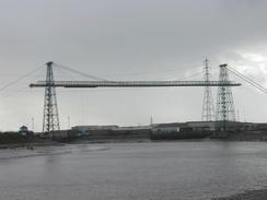
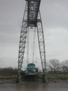
The transporter bridge over the River Usk is quite a magnificent structure. A transporter bridge consists of a high structure above the river, with a movable platform suspended below it that transports car between the two banks. The high towers allow tall ships to pass underneath the bridge to gain access to the docks further upstream. I had passed another transporter bridge in Middlesborough, and I must admit that the Newport one is much more aesthetically pleasing than the large metal construction over the Tees. On each bank there are two tall towers, set apart at the base and curving upwards to meet in the middle. Between the tops of the towers a long central span crosses the river. To hold the centre of this span up, a suspension bridge arrangement is used, with the towers going higher than the span and suspension cables drooping to meet the middle of the span. The ends of the suspension cables leave the towers and descend down to anchor blocks on the ground, making the entire structure look very elegant to my mind.
Although transporter bridges are far from suited for modern levels of traffic I am glad that two still exist (one in Runcorn no longer exists). When John Merrill did this walk in 1978 he actually crossed the River Usk using this bridge, as he climbed up the stairs in one of the towers on the eastern bank to the overhead crosspiece, and walked across that to the other side. I quite fancied doing this, but a local in the pub last night advised against it. I ended up crossing the river using the next bridge upstream, which is a fairly ugly cable-stayed structure. When I reached the other, western, side of the transporter bridge I discovered that the access door to the stairway up the towers was locked, and so I could not have climbed up the towers anyway. As I walked away from the bridge I could not help but turn around to look at it frequently as it got smaller behind me, as I found it that captivating. The bridge was opened on the 12th of September 1906 and was built to improve access to the Orb steelworks on the eastern side of the river. The towers are 342 feet high, and the span across the river between them is 592 feet. The tides in the channel beneath the bridge can be up to 47 feet, making a normal high-level bridge unfeasible. In June 1985 the bridge was closed to passengers and traffic as it was structurally unsafe, but rather than let the magnificent structure be demolished it was repaired, the work starting in 1992 and finishing in 1995.
I met Sam in Mervan near the bridge over the river in Newport, and I sat in the van whilst I ate my lunch. My feet were starting to ache, and as the rest of the day was going to be along roads I decided to change into my trainers for the last five miles. I had been wearing my waterproof trousers all morning and had not seen a drop of rain, so I also decided to take them off. This proved to be a big mistake, as the last hour of the walk had the heaviest rain that I can remember on this trip, and within five minutes my trousers and under trousers were soaked and my trainers were also saturated. I was walking through large puddles stretching halfway across the road, with cars and lorries coming past trying to spread that water from the road and over me. It was a thoroughly miserable experience and there was only one thing to do - I put a tape of music on my walkman and started singing at the top of my voice.
Directions
This walk stars off at the church in Redwick. Leave the church and head south along the road for a few yards to a track that leads through a farmyard for a little under a kilometre until it meets the flood bank beside the Severn. At the seawall turn right and head westwards along it. Immediately past Porton House the footpath turns to the right to head inland; however I continued on along the top of the flood bank for a little under a mile until reached a car park at Gold Cliff.
At the car park turn right to head northwards for half a mile until a road junction is met on the left near Clifton Court. Turn left down this road for half a mile into Goldcliff, where at a left-hand bend a footpath lead off to the left. Follow the top of the flood bank as it skirts the northern bank of Goldcliff Pill until it meets a track on the right. Here the footpath heads off to the right inland, but I continued on westwards beside the sea for another mile until a cycle path comes in from the right. This section of path is not a right of way, but the gate was open so I continued on.
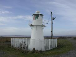
when the cycle path is met continue on along it as it passes a light and approaches a very tall pylon beside the river near the Uskmouth power station. Here the cycle track curves around to the right and follows various tracks through the ground of the power station; the way is well marked with red arrows on a background of a green circle.
The track eventually ends at a road, and then heads eastwards into the village of Nash. Head through the village and when the road ends at a T-junction with another road turn left down it to head northwards for about a kilometre, until a road junction is met on the right at Pye Corner. At this junction the cycle track heads off to the left along a well-made track that heads westwards and ends at the end of Corporation Road.
Turn right and head northwestwards up Corporation Road. This soon turns to the right to head northwards until it meets a junction with the A455 road. Join this and follow it as it heads northwestwards for a mile until the junction with the A48 George Street is met. Turn left down the A48 and follow it as it climbs up to cross over the River Usk. On the other side of the bridge descend down some steps and turn left to head south down the A4402 Usk Way.
Cross over a roundabout and continue on to another roundabout in Pillgwenlly. At this roundabout pass the entrance to the old lock down a footpath that curves to the right to head westwards along the bank of the river, giving good views of the transporter bridge. After a couple of hundred yards this path leaves the river and joins Usk Way at another roundabout.
At this roundabout turn left and follow Usk Way southwestwards past the western end of the transporter bridge to another roundabout, after which the way curves around to the right slowly before ending at another roundabout beside a railway bridge. Turn left at this roundabout and head under a railway bridge and join the cycle track. Just before a bridge over a railway line is met the cycle track head off to the right to join an old road bridge on Maeglas Road.
The cycle track eventually dives under the Usk Way and passes a football ground before crossing over the Ebbw River on a new bridge a turning to the right to end at the B3249 Lighthouse Road. At this road turn to the left and follow it southwards for a couple of miless to St Brides Wentlooge, where this walk ends.
Distances
| From | To | Distance (m) | Ascent (ft) | Descent (ft) |
|---|---|---|---|---|
| Redwick | Newport | 13.3 | 203 | 200 |
| Newport | St Brides Wentlooge | 5.4 | 69 | 59 |
This makes a total distance of 18.7 miles, with 272 feet of ascent and 259 feet of descent.
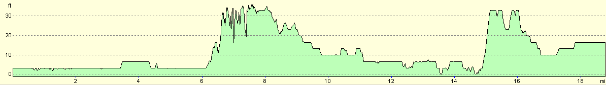
For more information on profiles, ascents and descents, see this page
Accommodation
We spent the night in the car park of the pub in St Brides Wentlooge who kindly let us park there.
Disclaimer
Please note that I take no responsibility for anything that may happen when following these directions. If you intend to follow this route, then please use the relevant maps and check the route out before you go out. As always when walking, use common sense and you should be fine.
If you find any information on any of these routes that is inaccurate, or you wish to add anything, then please email me.
All images on this site are © of the author. Any reproduction, retransmissions, or republication of all or part of any document found on this site is expressly prohibited, unless the author has explicitly granted its prior written consent to so reproduce, retransmit, or republish the material. All other rights reserved.
Although this site includes links providing convenient direct access to other Internet sites, I do not endorse, approve, certify or make warranties or representations as to the accuracy of the information on these sites.
And finally, enjoy your walking!
This walk was mentioned in the following routes:
| My walk around the coastline of Britain |
Nearby walks
| # | Title | Walk length (miles) |
|---|---|---|
| 369 | Clevedon to Severn Beach | 18.6 |
| 370 | Severn Beach to Redwick | 17.7 |
|
|

|