Walk #370: Severn Beach to Redwick
 |
 |
|
General Data
| Date Walked | 28/02/2003 |
| County | Avon, Gwent |
| Start Location | Severn Beach |
| End Location | Redwick |
| Start time | 09.08 |
| End time | 15.34 |
| Distance | 17.7 miles |
| Description | After a couple of days that were slightly boring, this was a lovely day, the highlight of which has to be crossing over the Severn into Wales. |
| Pack | Today I carried my 30-litre Karrimor HotRock rucksack, which was filled with my packed lunch, waterproof leggings, water bottle and a couple of spare shirts, together with the usual assortment of odds and ends. |
| Condition | I feel absolutely fine after this walk, and have nothing to report. My feet ached much less than they have on recent walks, and the blisters gave me little trouble either. |
| Weather | After a long spell of relatively dry weather, the skies finally opened today. The walk started off dry, but clouds soon gathered and a light drizzle started, accompanied with a stiff breeze that was very noticeable when crossing the Severn. As the day went on the rain got harder, and by the end of the walk I was very wet and it was raining much harder. This made me feel quite miserable, and I as glad to see the van so that I could strip off to get dry and warm. |
| OS map | Landranger number 172 (Bristol & Bath, Thornbury & Chew Magna) |
 |
 |
|
 |
 |
|
Map of the walk
Maps courtesy of Google Maps. Route for indicative purposes only, and may have been plotted after the walk. Please let me have comments on what you think of this new format. For a detailed table of timings for this walk, please see the table file.
Notes
Being in Wales is nice, and I feel that it is a sign that I am making good progress on the walk now that I have started the third country of my walk. I was rather annoyed that when I crossed the Severn Bridge there was no 'Welcome to Wales' sign on the bridge for people to photograph - this compares rather poorly with the Saltash Bridge, which has loads of Cornwall and Devon signs everywhere. Surely a few signs for the pedestrians would not cost too much?
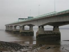
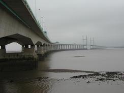
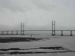
The crossing of the Severn Bridge was quite enjoyable, although breezy at times. The suspension bridge is quite stunning - the main span is 3,240 foot long, the towers are 400 foot high and the suspension cables contain over 20,000 miles of wire. The bridge opened in 1966 and replaced the car ferry that used to ply the waters below. Unfortunately due to the poor weather I did not get the expansive views that I was expecting, and the views to the south are spoiled somewhat about some power lines that cross the river a few hundred yards away from the bridge. The border between England and Wales is not in the middle of he Severn as I was expecting, but actually down the middle of the Wye, which is crossed by a smaller bridge immediately to the west of the main span.
Sam had organised for me to do a radio interview with BBC Wales, and they gave me quite an accurate time to expect the call. As the time approached I was right by the new Severn Bridge, and the rain, wind and noise of the traffic was quite annoying. I dive under the approach viaduct to the bridge itself was an oasis of quiet compared to the situation outside, so I sat down and did the interview there - another strange place that I have done an interview to add to my list! A little later on my map showed a rifle range, and as I approached I could see large red flags flying and also hear many shots. There was not an easy way around the range and so I decide to approach the guard hut and see if I could pass through. When I reached the hut I was very surprised to see a policemen there - it turned out that the police were using the army range. They kindly let me pass through the range, and fortunately they also stopped firing whilst I did so!
In what is becoming a very common and disconcerting habit, I managed to myself lost again today. This I blame not on a terrible sense of navigation but on the woeful state of he way markers in this area. The first place that I had trouble was finding my way to Mathern from the large industrial park below junction 2 of the M48. I spent a few minutes trying to find a stile into the field where I believed that the footpath should go, and eventually I gave in and climbed over the gate. I used the tower of Mathern Church as a marker, and I managed to find my way quite easily into the village. I emerged from the farmyard about five yards away from a signpost for the footpath that I had been trying to find.
The next situation was much worse. I passed the Mathern Church and continued on, following a sign stating coastal path that led along a distinct track along the ground. Unfortunately I soon realised that I was on the wrong, eastern, side of the St Pierre Pill. I walked along the eastern bank looking for an easy place to cross the stream, but it was too wide and deep to avoid me getting quite wet in crossing it, and so I decided to cross it at the railway bridge - naughty, but probably safer than crossing the stream. Fortunately this did not prove to be necessary, as a few yards upstream of the rail bridge there was a culvert over the stream that allowed me to easily cross to the western bank. From here the rest of the walk was along the flood bank, which whilst fairly boring made the navigation far easier!
Redwick is a lovely little village, and we enjoyed having a walk around the church one the rain had stopped, although the wind was blowing us all over the place as we did so. Unfortunately we could not look inside the church as it was locked, and we could not be bothered to ring up to ask for the key. We went into the local pub (the Ship Inn) this evening, and had a drink or two and did a collection - the locals were all very kind and welcoming, and were a great introduction to Wales.
Directions
This walk starts off at Beach Road in Severn Beach. Leave the road and walk up to the top of the sea wall and turn right to head northwards along the wall, following the Severn Way. Follow it as it passes under the new Severn Bridge and passes a few houses at New Passage. Here the wall ends and a flood bank continues around a little creek before turning to head northwestwards for a couple of miles until it meets a road at Cake Pill Gout. Here leave the Severn Way and turn left to follow the road as it turns to the right and climbs uphill eastwards towards the village of Aust.
Just before this road meets the A403 a service road heads off to the left, passing the Severn Bridge service area on the right before heading on alongside the motorway until the toll booths are reached. Here do not turn right to cross the bridge over the motorway but continue on along the road, which eventually descends to join the southern side of the Severn Bridge. Cross the bridge using the pedestrian walkway, and when you reach the Welsh bank descend down.
Instead of turning right along the cycle route to Chepstow continue straight on along a small tarmac path that heads along the motorway before descending down into a large area of warehouses. Join a road that heads southwards for a couple of hundred yards before ending at a junction with a larger road, and then turn right down this road past the warehouses. The end of this road curves to the right before ending at a roundabout. According to the map a footpath leads off from here and leads towards Mathern Church; I could not find this footpath and so I made my own way across fields, having taken a bearing on the church tower using my compass.
When you reach Mathern Church do not turn left to enter the church but continue straight on, passing to the right of the churchyard. The path crosses a stream and then turns to the left to head southwards down the western bank of the stream. Here I got slightly lost, and I ended up joining a path that heads south along the eastern bank of St Pierre Pill when I was trying to find the footpath on the western bank. Fortunately after I had passed under the two sets of power lines I found a bridge that allowed me to get access to the western bank, and I continued on to cross the railway line and join the top of the flood bank.
Turn to the right and follow the footpath southwestwards along the top of the flood bank and, before it ends, where the footpath heads up a hill to meet a road. Cross the road and join a track that heads for a kilometre into the village of Sudbrook. When the track ends at a road turn to the right past a factory and then turn left to cross a level crossing over a railway line. On the other side of the crossing turn left and pass the Sudbrook non-political club before the road ends and a footpath continues on westwards. The path passes a very ruinous and overgrown chapel and then a paper mill before diving under the new Severn bridge.
Continue on as the path follows the top of the flood bank as it passes West Pill (where the is a rifle range), Collister Pill, Magor Pill and finally Cold Harbour Pill. There is not a footpath for the entire way along the bank, but it was easy enough to follow through the small gaps in the footpath network. About a mile southwest of Cold Harbour Pill a track leads off to the right and heads northwestwards into the village of Redwick, where this walk ends.
Distances
| From | To | Distance (m) | Ascent (ft) | Descent (ft) |
|---|---|---|---|---|
| Severn Beach | Marthen | 7.8 | 328 | 308 |
| Marthen | Redwick | 9.9 | 125 | 157 |
This makes a total distance of 17.7 miles, with 453 feet of ascent and 465 feet of descent.
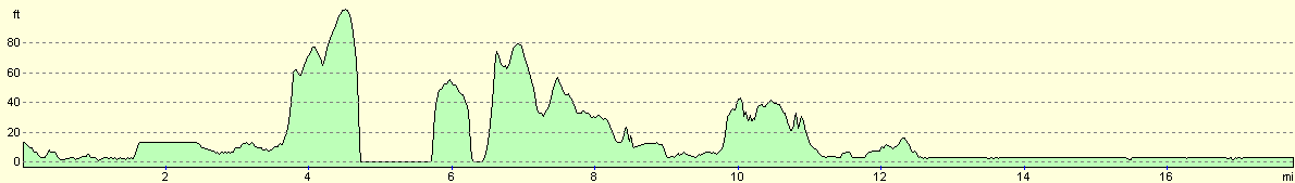
For more information on profiles, ascents and descents, see this page
Accommodation
We parked Mervan in the car park of the village hall in Redwick, which is directly opposite the lovely church and next door to the Ship Inn. This evening we realised that this was exactly where Spud had parked her van when she did this walk back in 1994. When we went into the pub we also realised that Sam had parked Mervan in the middle of the village Boules Court, which was slightly embarrassing but understandable as it was unfenced and right beside the road - it just looked like a gravel parking area!
Disclaimer
Please note that I take no responsibility for anything that may happen when following these directions. If you intend to follow this route, then please use the relevant maps and check the route out before you go out. As always when walking, use common sense and you should be fine.
If you find any information on any of these routes that is inaccurate, or you wish to add anything, then please email me.
All images on this site are © of the author. Any reproduction, retransmissions, or republication of all or part of any document found on this site is expressly prohibited, unless the author has explicitly granted its prior written consent to so reproduce, retransmit, or republish the material. All other rights reserved.
Although this site includes links providing convenient direct access to other Internet sites, I do not endorse, approve, certify or make warranties or representations as to the accuracy of the information on these sites.
And finally, enjoy your walking!
This walk was mentioned in the following routes:
| My walk around the coastline of Britain |
Nearby walks
| # | Title | Walk length (miles) |
|---|---|---|
| 369 | Clevedon to Severn Beach | 18.6 |
| 371 | Redwick to St Brides Wentlooge | 18.7 |
| 759 | Sedbury Cliffs to Monmouth | 20.0 |
|
|

|