Walk #369: Clevedon to Severn Beach
 |
 |
|
General Data
| Date Walked | 27/02/2003 |
| County | Somerset, Avon |
| Start Location | Clevedon |
| End Location | Severn Beach |
| Start time | 08.39 |
| End time | 16.22 |
| Distance | 18.6 miles |
| Description | This was a fairly boring positional walk, and one that really did not have any high points. There were some enjoyable sections but also some sections that were extremely tedious. |
| Pack | Today I carried my 30-litre Karrimor HotRock rucksack, which was filled with my packed lunch, waterproof leggings, water bottle and a couple of spare shirts, together with the usual assortment of odds and ends. |
| Condition | I am glad to say that my feet are in a better condition than they were after yesterday's walk, but they still ached and made the last couple of miles of the walk unenjoyable. I felt fairly nauseous as I walked at times, and this made the walk seem to drag on forever. I am hoping that my feet get better as time goes on, but I may walk a shorter distance tomorrow to try and ensure that. |
| Weather | The weather today was always cloudy, with no real sight of the sun. It was quite warm, but there were occasional patches of rain that were not heavy enough to get me wet. Mum and dad had some heavy rain where they were elsewhere in Somerset, so all in all I was quite lucky to remain dry. |
| OS map | Landranger number 172 (Bristol & Bath, Thornbury & Chew Magna) |
 |
 |
|
 |
 |
|
Map of the walk
Maps courtesy of Google Maps. Route for indicative purposes only, and may have been plotted after the walk. Please let me have comments on what you think of this new format. For a detailed table of timings for this walk, please see the table file.
 |
Notes
I really did not enjoy this walk much, mainly because the walking was mainly along roads, and it also passed through some unscenic and fairly depressing industrial areas. This is a slight shock after the beauty of the North Devon and Somerset sections of the South West Coast Path, but I suppose that you have to go through unscenic areas to get to scenic ones, and that such areas make you appreciate the beautiful areas all the more. I must admit, however, that I wish that I could miss out stretches like the one north from Avonmouth, as it had very little to commend it. Even the section that was a footpath was very grotty, despite it being part of a named path (the Severn Way Bristol Link path).
By the time lunchtime arrived I was really desperately in need of the toilet. At eleven I was passing the Royal Hotel, but they were not opening for another half hour. I walked on and diverted off my route into the centre of the town and seemed to walk down the entire high street before I finally found a pub that was open, the Poacher. I went in and had a pint of Smiles and used their facilities, after which I could walk with slightly less stress. Annoyingly the distance that I walked through he town was unnecessary, as five minutes down the A369 there was a new Brewers Fayre pub, right on my route. I could have easily nipped in there instead and saved myself that longer walk if I had known, but that is the benefit of local knowledge.
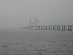
As I walked around Battery Point in Portishead I got my first view of the second Severn river crossing in the distance. This was a real 'wow' moment, and although it was quite indistinct in the hazy sky it was still a lovely sight. As the day went on I got more and more views of the bridge, which I quite admire. Unlike the original Severn bridge that I shall be crossing tomorrow the second crossing is a cable-stayed bridge, which, whist it looks similar, is very different to a suspension bridge such as the original crossing. The two bridges are quite different, as the original bridge is a very long suspension bridge with short approach viaducts, and the second crossing is a relatively short span cable-stayed bridge with very long approach viaducts. The second bridge was built over the Severn rail tunnel, which is the longest rail tunnel in Britain at four miles in length.
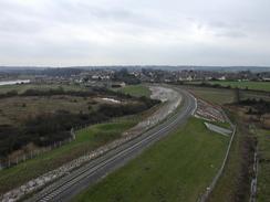
The biggest obstacle on this walk was the River Avon, and I chose to cross it on the very large and dominant Avonmouth Bridge, which carries the M5 over the river. There is a footpath and cycleway over the bridge, which was of a fairly unusual design when it was built. I have many happy memories of crossing this bridge when going down to family holidays in Devon when I was a child, as it marked the point when we were entering the southwest. It also meant a stop in the journey, as we almost invariably stopped at the Gordano services immediately south of the bridge. Part of the walk today took me along a footpath that was sandwiched between the M5 and the services, and any nostalgia that I may have felt was overridden by the noise, fumes and the disgusting amounts of rubbish that lay over the path. The walk over the bridge itself was quite nice, but I enjoyed it less than walks over more spectacular bridges.
Whilst walking past Avonmouth Station I saw two policemen knocking at the front door of a flat as I walked towards it along the road. They then started taking it in turns kicking at the door, and as I walked past they went around the back and started attacking the windows with their nightsticks. They seemed quite annoyed, and were swinging their sticks with gusto. Although I was curious about what was going on I just walked on as it was none of my business, but something looked slightly strange about the situation.
Tomorrow I shall be reaching Wales, the third country of my walk. It is going to feel fairly strange to be in the Principality, and I think it shall take me a few days to get used to the fact that I am no longer in England. I am really looking forward to crossing the original Severn Bridge tomorrow and entering Wales, and I wish that I could be out walking it now - I can hardly wait. I love suspension bridges, and walking over the Severn will be the second large suspension bridge of the walk - the first was the Humber Bridge and the last will be the Forth Bridge.
Directions
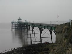
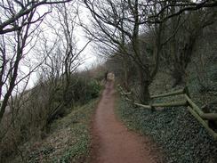
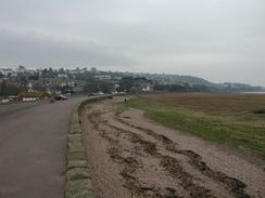
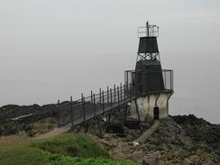
This walk starts off beside the pier in Clevedon. From the pier walk northeastwards along the road along the seafront as it climbs uphill. When a main road comes in from the right take a surfaced footpath that descends to the left before turning to the right and heading northeastwards along the coast. The path passes Ladye Point before continuing on into the outskirts of Portishead. In Redcliff Bay the path joins the verge beside a residential road for a few yards before diverting off to the left one more beside the sea. Keep to the path as it passes a large light and the Portishead lifeboat station and curves around Kilkenny Bay before joining a road at Woodhill Bay. Walk along the road or the beach until he end of the beach and then climb up to the light at Battery Point.
From Battery Point head eastwards along a path for a short distance through some woodland until it meets a road. Turn left down this road and follow it around past the Royal Hotel and up a slight hill. Turn left down a road that heads south through a housing estate before ending at the A369 road. Join the A369 road and follow it as it curves around to head southeastwards. Cross over one roundabout next to a pub and at the next roundabout turn left to head eastwards along a road towards Sheepway. The road climbs over a disused railway line before reaching the little village, where it curves around to head southwards, crossing over the railway line once more before ending at the A369 road. Do not join the A369 but take a pedestrian footbridge that goes over the A369 road and the adjacent M5.
On the other, southern, side of the footbridge join a minor road that heads up a slight hill for a few hundred yards before ending at a T-junction with a larger road. Turn left down this road and head eastwards out of the village. When Church Lane is met on the left turn down it and follow it past the church before taking a footpath that leads off to the left. This footpath heads across a field towards a ramp that leads up onto the roundabout above junction 19 of the M5. Cross the A369 road where it meets the roundabout and then cross the entrance and exit roads from the services, before taking a footpath that heads eastwards squeezed between the M5 on the left and the services on the right. When the services end the path emerges into a field beside a mobile phone transmitter and angles towards the tower of a church.
Join the road and walk down towards the church. Continue on along roads through the village northeastwards, making the way towards the disused railway line. A bridge leads under the railway line and ends at a road. Turn left up this road (which is closed to traffic) and pass under a brand new, low, Railway Bridge until a ramp is met that leads up onto the top of the M5 Avonmouth Bridge. Climb up this ramp and cross the bride over the river. On the other side the path descends down to meet a dual carriageway road. Turn left to pass under the motorway and continue on to a large roundabout, which you cross over carefully and head along a local road into Avonmouth until Avonmouth Station is reached on the left.
Continue along the road past the station and almost immediately take a road that leads off to the right to head northwards for a short distance to a roundabout with the A403 road. Cross over the roundabout and continue straight on down the A403 northwards, passing St Andrews Road Station. The road curves to the right to cross over a level crossing before curving to the left and reaching a roundabout.
Cross over the roundabout and follow the road as it climbs up to cross a bridge over a railway line before descending down on the other side and curving to the right. On the bend a footpath, named the Severn Way Bristol Link, leads off to the left. This path passes to the left of a large industrial building before crossing a railway line that leads into a factory. The path along this section is very indistinct and the situation on the ground is changing (railway lines had been disconnected), so follow the route on the map and the way markers.
The path passes between a railway line on the left and the factory buildings on the right. When the factory buildings end the path continues on with the railway lone on the left. It joins the A403 once again at a lay-by and continues along the verge for a few hundred yards (there is no pavement beside the road) before diving off to the left. It crosses over the railway line and joins a better quality path as it continues on northwards into Severn Beach. This walk ends at Beach Road in Severn Beach, which is quite near to the station and has good views of the second Severn crossing.
Distances
| From | To | Distance (m) | Ascent (ft) | Descent (ft) |
|---|---|---|---|---|
| Clevedon | Portbury | 10.6 | 1352 | 1335 |
| Portbury | Severn Beach | 8.0 | 180 | 217 |
This makes a total distance of 18.6 miles, with 1532 feet of ascent and 1552 feet of descent.
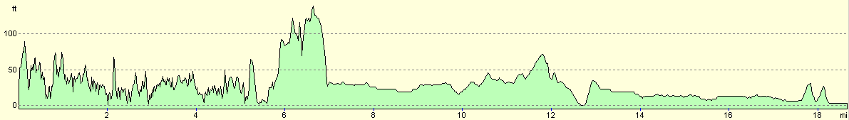
For more information on profiles, ascents and descents, see this page
Accommodation
We spent he night at the caravan site at Cliff Farm, Aust, Bristol BR35 4BG. This site cost us eight pounds for the night, with fifty pence added on for the showers, which were nice and warm although in an unheated room. The site had some great views of the suspension bridge over the river Severn that I will be crossing tomorrow, although we had a problem when the power to the site cut out for a couple of hours this evening.
Disclaimer
Please note that I take no responsibility for anything that may happen when following these directions. If you intend to follow this route, then please use the relevant maps and check the route out before you go out. As always when walking, use common sense and you should be fine.
If you find any information on any of these routes that is inaccurate, or you wish to add anything, then please email me.
All images on this site are © of the author. Any reproduction, retransmissions, or republication of all or part of any document found on this site is expressly prohibited, unless the author has explicitly granted its prior written consent to so reproduce, retransmit, or republish the material. All other rights reserved.
Although this site includes links providing convenient direct access to other Internet sites, I do not endorse, approve, certify or make warranties or representations as to the accuracy of the information on these sites.
And finally, enjoy your walking!
This walk was mentioned in the following routes:
| My walk around the coastline of Britain |
Nearby walks
| # | Title | Walk length (miles) |
|---|---|---|
| 368 | Weston-Super-Mare to Clevedon | 18.9 |
| 370 | Severn Beach to Redwick | 17.7 |
| 371 | Redwick to St Brides Wentlooge | 18.7 |
|
|

|