Walk #368: Weston-Super-Mare to Clevedon
 |
 |
|
General Data
| Date Walked | 26/02/2003 |
| County | Somerset, Avon |
| Start Location | Weston-Super-Mare |
| End Location | Clevedon |
| Start time | 07.27 |
| End time | 15.02 |
| Distance | 18.9 miles |
| Description | This was a fairly boring walk, with not much to distinguish it. Indeed there were some exceedingly grotty bits, and bits where there have to be better routes. |
| Pack | Today I carried my 30-litre Karrimor HotRock rucksack, which was filled with my packed lunch, waterproof leggings, water bottle and a couple of spare shirts, together with the usual assortment of odds and ends. |
| Condition | In a rather sadistic way I am quite pleased that I have tripled my blister count on this trip overnight. The hot spots that have developed on both my feet over the last few days have become deep blisters, and these made the last few miles of the walk extremely wearisome. To make matters worse, the Compeeds that I have are out of date and do not stick properly, so I am having to rely on a sub optimal replacement. Aside from this I had no other problems, and everything else is okay. |
| Weather | The weather today was cloudy with occasional periods of sunshine. There was not much wind and it was quite warm, and all this made it a nice day for a walk. |
| OS map | Landranger number 182 (Weston-super-Mare, Bridgwater & Wells) and Landranger number 172 (Bristol & Bath, Thornbury & Chew Magna) |
 |
 |
|
 |
 |
|
Map of the walk
Maps courtesy of Google Maps. Route for indicative purposes only, and may have been plotted after the walk. Please let me have comments on what you think of this new format. For a detailed table of timings for this walk, please see the table file.
 |
 |
|
Notes
All in all this walk was a bit if a disappointment. The stretch from Sand Point to Clevedon was along roads and footpaths, which made this a boring and fairly uninteresting walk. A man I met near to Woodspring Priory told me that the council is attempting to get a footpath made along the sea wall between these two points, but one landowner is resisting. This is a great shame as it would be a far better walk than the inland route that I had to take. This involve crossing the M5 twice, firstly using a pipe bridge under the motorway (this could be slightly naughty as I am unsure about whether this was a right of way), and secondly by using a small bridge that carried a farm track over the motorway. This whole stretch really did not have much going for it, and it was one of the least enjoyable stretches of walk that I have had to do for some time.
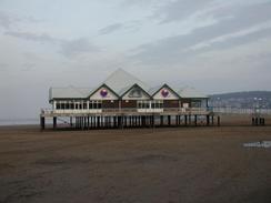
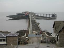
I had last been to Weston-Super-Mare with my primary school when I was a child, and all I can really remember of the week is of playing in massive sand dunes that towered over my head. I must have been much shorter then, as the sand dunes are actually quite small when compared with the monsters I have seen in places like Braunton Burrows. I found the town itself to be quite nice - at least from the promenade as I walked along it - and relatively unspoilt by amusement arcades. The Grand Pier also looked quite nice and not overly commercialised, but I was saddened to see the state of the Birnbeck Pier. This was closed to the public and fairly derelict, although some renovation work did appear to be being done on it. This seemed to consist of replacing wooden boards on the pier, which surprised me as I would have expected the metal superstructure to be renovated first.
Both of my feet gave me trouble today, and in particular towards the end of the day I found it quite hard to walk. I have been pushing on through the last few days - I have successfully managed over eighty miles in four days, which is a record for me. A few days ago I noticed hot spots near the ball of each foot, and unfortunately today these turned into deep blisters. I am quite amazed that after nearly 2,500 miles I have only had three blisters - my feet have been in a fairly good state until the last couple of days. I may have to walk reduced mileages for the next couple of days until these blisters go, but I am still quite keen to get ahead of schedule.
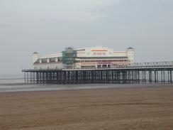
On Wain's Hill to the south of Clevedon I me mum and dad, and we walked back together towards Mervan, which was parked near to the very attractive pier. As I walked with them I had a phone call from BBC radio Somerset Sound, and so I had to sit down on a bench beside the promenade so that I could do the interview. Again this went quite well, and I must admit that I feel like I am getting more at home with doing interviews. Eventually we got to Mervan, and mum and dad left whilst I went in to get changed and have a rest. An hour later they came back, and the four of us went out to a local restaurant for a meal. It has been absolutely superb to see them, and it has made me realise how much Sam must be missing her family in Australia.
I am now nearing Bristol, and the day after tomorrow I should cross over the old Severn Bridge into Wales. This will be a major milestone of the walk, as it will be the start of my third country of the walk. Wales shall also be my first country to complete, with England being completed after and Scotland finally when I reach Edinburgh at the end of the walk. I am very much looking forward to reaching the principality, and in particular I can hardly wait for the walk along the Pembrokeshire Cast Path and further on up the east cost. Before I can get to Wales, however, I still have over a day's walk to complete, and much of this promises to be through built-up areas.
Directions
This walk starts off by the promenade in Weston-Super-Mare, beside the leisure pool. The directions through the town are quite simple; follow the promenade as it heads northwards before turning to head northwestwards past Knightstone and the Marine Lake. The promenade continues to curve around until the Birnbeck Pier is reached, where the promenade ends. Climb up to the right to join the road and turn left along this to head eastwards along the northern flank of Worlebury Hill. After a couple of kilometres there is a car park on the left; drop down into the car park and from there onto the beach at the southern end of Sand Bay.
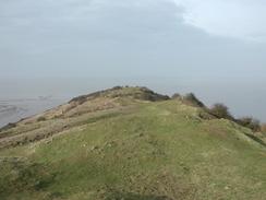
Walk north along either the beach or the path beside the road at the edge of the beach. When a car park is reached at the northern end of the beach take a footpath that heads up some steps and onto the top of Sand Point. Follow the path to the trig point and then turn around to head eastwards along a path along the top of the ridge. After a little over a kilometre a surfaced track is crossed, and from here follow footpath signs towards Woodspring Priory. The path ends at a car park near a flood bank, and from here head westwards for a short distance towards some large barns. At the barns turn left to head southwards along a public road.
When a track leading to Collum Farm leads off to the left take this track, and when it curves to the left continue straight on along a bridleway. This is very indistinct on the ground, but head eastwards towards the tower of Wick St Lawrence Church until a track is reached to the west of the River Banwell. Join this track and follow it southwards until it ends at a road in Ebdon. Turn left along this road and cross over the river on a bridge before it ends at a T-junction. Turn left at this junction and follow this new road as it heads northwestwards for a short distance beside the river before curving to head eastwards into Wick St Lawrence.
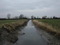
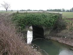
Pass the church in the village and continue on as the road curves to the right to head southeastwards at Icelton. Continue on for about another kilometre before turning to the left down a minor road. This soon ends, but a footpath continues on through a gate (bestowed with a 'beware of the bull' sign) and crosses the Oldbridge River before heading across a field and ending at the flood bank beside the River Yeo. Turn right and walk south for a short distance down the flood bank until the M5 is reached. I managed to cross the M5 by walking about fifty yards to the right and then climbing a fence to gain access to a bridge that carries a large pipe in a culvert under the motorway. I am unsure about whether this is a legal right of way, but it was far safer than crossing the motorway on the level.
On the other side of the motorway turn left to walk along the southern bank of the River Yeo - there is no right of way along this bank, but it was an easy enough walk. When the Phipps Sluice is reached turn left to cross the river on a bridge beside the sluice. From the map I believed that I could cross the motorway here, but I decided that the only possible route - under the motorway using a pipe bridge - was unsafe, so I turned to the right and walked along the northern bank of a little River northeastwards for a kilometre until a little building is reached. At the building turn left and join a track that climbs over the motorway on a bridge. The track continues along on the northern side of the motorway. Pass one track that leads off to the left towards a large shed before taking the next track to the left. This track curves around before ending at a road after a kilometre.
At this road turn left and walk northwestwards to Ham Farm. Here the road curves to the right to head northwards before ending at another road junction. Turn left to walk towards Channel View, where the road curves sharply to head northeastwards and then eastwards for about a kilometre. When another road junction is reached turn left to head northwards for a little over a kilometre, before it turns to the right to head eastwards towards two large aerials. At another junction turn to the left to head northwards to a bridge over the Blind Yeo.
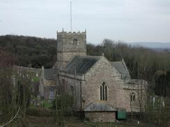
On the northern side of the Blind Yeo channel turn left along a track that follows the northern bank of the channel until a sluice is reached. At the sluice turn to the right and follow a track around that leads to the base of Wain's Hill. Here a slope or some steep steps leads up to the top of the hill, the top of which can then be followed around until the sea is met. A good path descends down past a church to reach Salthouse Bay. Here a promenade can be followed northeastwards to the pier in Clevedon, where this walk ends.
Distances
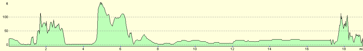
| From | To | Distance (m) | Ascent (ft) | Descent (ft) |
|---|---|---|---|---|
| Weston-Super-Mare | Wick St Lawrence | 9.2 | 587 | 594 |
| Wick St Lawrence | Clevedon | 9.7 | 328 | 315 |
This makes a total distance of 18.9 miles, with 915 feet of ascent and 909 feet of descent.
For more information on profiles, ascents and descents, see this page
Accommodation
We parked Mervan on the street beside the promenade in Clevedon, very near to the pier. There were no parking restrictions that I could see, and it was very convenient for the local amenities.
Disclaimer
Please note that I take no responsibility for anything that may happen when following these directions. If you intend to follow this route, then please use the relevant maps and check the route out before you go out. As always when walking, use common sense and you should be fine.
If you find any information on any of these routes that is inaccurate, or you wish to add anything, then please email me.
All images on this site are © of the author. Any reproduction, retransmissions, or republication of all or part of any document found on this site is expressly prohibited, unless the author has explicitly granted its prior written consent to so reproduce, retransmit, or republish the material. All other rights reserved.
Although this site includes links providing convenient direct access to other Internet sites, I do not endorse, approve, certify or make warranties or representations as to the accuracy of the information on these sites.
And finally, enjoy your walking!
This walk was mentioned in the following routes:
| My walk around the coastline of Britain |
Nearby walks
| # | Title | Walk length (miles) |
|---|---|---|
| 367 | Highbridge to Weston-Super-Mare | 20.0 |
|
|

|