Walk #367: Highbridge to Weston-Super-Mare
 |
 |
|
General Data
| Date Walked | 25/02/2003 |
| County | Somerset |
| Start Location | Highbridge |
| End Location | Weston-Super-Mare |
| Start time | 08.37 |
| End time | 16.31 |
| Distance | 20.0 miles |
| Description | This was a long but generally lovely walk, with the walk along Brean Down being the literal and metaphorical high point. Unfortunately this was followed by a long road and footpath walk to get around the River Axe. |
| Pack | Today I carried my 30-litre Karrimor HotRock rucksack, which was filled with my packed lunch, waterproof leggings, water bottle and a couple of spare shirts, together with the usual assortment of odds and ends. |
| Condition | The main problem at the end of today is the underside of my feet, which ache considerably. This is probably to be expected after walking over sixty miles in three days, and I am glad that this is the only notable problem that I have had. |
| Weather | Today's weather was quite nice, with patchy cloud and occasional sunshine. There was no repetition of yesterday's fog, and it never looked as though it would rain. All in all it was not a bad day at all. |
| OS map | Landranger number 182 (Weston-super-Mare, Bridgwater & Wells) |
 |
 |
|
 |
 |
|
Map of the walk
Maps courtesy of Google Maps. Route for indicative purposes only, and may have been plotted after the walk. Please let me have comments on what you think of this new format. For a detailed table of timings for this walk, please see the table file.
 |
 |
|
 |
Notes
This walk started quite well, as I managed to get lost in Highbridge. I spent twenty minutes walking around before ending up exactly where I began. This was because I decided to walk along the road that runs along the northern bank of the River Brue, but unfortunately I discovered that this road ends at a boat yard, from where no access is possible to the river bank along which I needed to progress. I therefore needed to walk back to the roundabout on the A38, where I restarted the log of the walk once again. I was very annoyed about this, as when I looked on the map it very clearly shows that the footpath does not start from the road that I initially walked along, and thus it was a very silly mistake to make.
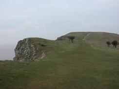
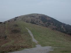
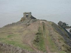
Brean Down was an extremely impressive lump of rocks, and I enjoyed the views that I got from the top of it. I could see Steep Holme out to sea, Weston-Super-Mare to the north and the long beach down to Burnham-on-Sea to the south. If the weather had been clearer I could probably have easily seen the coast of South Wales, but unfortunately it was very hazy. At the end of the down is a fort with many intact buildings, and I spent ten minutes walking around the extant buildings, wondering what it must have been like to work there.
I had to make a big diversion inland to get around the River Axe. This was annoying, and there is a sluice marked on the map that I hoped would make an early crossing point and cut out a few miles Unfortunately I could see from the road that the sluice had gates at both ends, and so I decided that attempting to cross it was not worth the effort just to lose a few miles extra walking.
Late in he afternoon I received a phone call from BBC Radio Somerset Sound so that I could have my daily interview. I had a look around and a few yards ahead was a bird hide, so I climbed up the steps into it to get out of the wind. They had phoned me up a little early, so I was listening in the dark when a man opened the door. He seemed started to see me in the hide, and I asked him if he could leave me alone for a few minutes as I was doing a radio interview. He gave me a very quizzical look and apologised before leaving - a very unusual experience.
Directions
This walk starts off at the roundabout on the A38 in the town of Highbridge. From the roundabout take a road that head westwards paralleling but separate from the river. Do not try to take the road that heads off beside the river, as this ends at a boatyard where onward progress is impossible. When the road turns slightly to the left continue straight on down a cycle track that is part of the old railway line to Burnham-on-Sea. When the tracks enters a play area head half-left away from the track towards the end of the boatyard, where access can be got to the flood bank beside the river. Join the flood bank and follow it as it heads westwards along the northern bank.
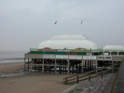
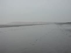
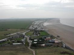
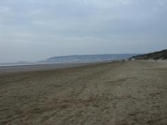
At the river mouth the bank turns to the right to head north, passing a little marina before joining the promenade in Burnham-on-Sea. Walk north along the promenade, passing the pier until it eventually ends. When it ends join the beach and walk northwards for nearly six miles until it ends at the cliffs of Brean Down. Leave the beach and join the car park beside the cafe. From here a path lead up some steps onto the top of the down, from where some great views are available to the south along the beach. At the top of the cliffs follow an obvious path that heads westwards to the trig point at the top of the Down before descending down to the old fort.
Leave the fort and walk back along the access road, which climbs slowly as it heads eastward. When you reach the place where the steps were leading up to the down take a footpath to the right that leads a short distance uphill to the top of the steps. Descend the steps down into the car park once again. If you want to extend he walk then you can do so by avoiding the steps and walking along the access road as it winds its way down to the car park. Leave the car park and head south for a mile and a half along the road until a junction with a road is met on the left near Brean Church. Turn down this road and follow it eastwards until it turns to the right to head southwards after a kilometre, passing Ham Farm before reaching a junction with Red Road. At the junction turn to the left to head eastwards for about a kilometre until Wick Farm is reached.
At the farm turn left up a little track. This immediately curves to the right before ending beside a cottage, where a path continues on to the left. Follow this path northwards as it enters a field. The footpath through the fields in unmarked, but when a sluice gate on a drain is reached turn to the right and follow the drain eastward. The path joins the end of a track that continues on for about fifty yards before ending at a road beside a rail bridge. Turn left down this road and follow it northwards beside a railway line, finally crossing over the river. The road passes under some power lines and shortly afterwards a cottage is passed on the left. After this cottage a track lead off to the left.
Take this track as it curves around Bleadon Level before settling on a northerly course. It passes the new sewage works before reaching and crossing the access road to the works. Continue on along the track as it joins the riverbank before ending at a road in Uphill. Turn left to pass a sluice and on the other side turn left down another footpath on top of a flood bank. This bank heads south for a short distance before turning sharply to head back northwestwards before ending at the dunes of the beach. Follow the beach northwards past Uphill and onwards, with some sand dunes on the right before the promenade in Weston-Super-Mare is reached. This walk ends on the promenade near the leisure pool.
Distances
| From | To | Distance (m) | Ascent (ft) | Descent (ft) |
|---|---|---|---|---|
| Highbridge | Brean Down Fort | 9.7 | 623 | 591 |
| Brean Down Fort | Weston-Super-Mare | 10.3 | 472 | 489 |
This makes a total distance of 20.0 miles, with 1095 feet of ascent and 1080 feet of descent.
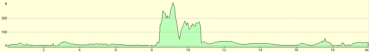
For more information on profiles, ascents and descents, see this page
Accommodation
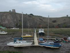
We could not park overnight on the roadside beside the promenade to the south of Weston-Super-Mare, so we decided to drive back into Uphill where Sam had spotted a couple of pubs. We ended up parking on the roadside between the Ship Inn and The Dolphin.
Disclaimer
Please note that I take no responsibility for anything that may happen when following these directions. If you intend to follow this route, then please use the relevant maps and check the route out before you go out. As always when walking, use common sense and you should be fine.
If you find any information on any of these routes that is inaccurate, or you wish to add anything, then please email me.
All images on this site are © of the author. Any reproduction, retransmissions, or republication of all or part of any document found on this site is expressly prohibited, unless the author has explicitly granted its prior written consent to so reproduce, retransmit, or republish the material. All other rights reserved.
Although this site includes links providing convenient direct access to other Internet sites, I do not endorse, approve, certify or make warranties or representations as to the accuracy of the information on these sites.
And finally, enjoy your walking!
This walk was mentioned in the following routes:
| My walk around the coastline of Britain |
Nearby walks
| # | Title | Walk length (miles) |
|---|---|---|
| 365 | Watchet to Steart | 17.3 |
| 366 | Steart to Highbridge | 25.2 |
|
|

|