Walk #365: Watchet to Steart
 |
 |
|
General Data
| Date Walked | 23/02/2003 |
| County | Somerset |
| Start Location | Watchet |
| End Location | Steart |
| Start time | 09.20 |
| End time | 16.00 |
| Distance | 17.3 miles |
| Description | This as mostly a highly enjoyable day, particularly the middle section along the cliffs towards the Hinckley Point power stations. |
| Pack | Today I carried my 30-litre Karrimor HotRock rucksack, which was filled with my packed lunch, waterproof leggings, water bottle and a couple of spare shirts, together with the usual assortment of odds and ends. |
| Condition | I had a problem today with the underside of my feet, as I used an old and worn pair of 1000-mile socks. About four miles before the end of the walk this caused the underside of my feet to hurt, and this was highly annoying. Aside from this I had no other problems, although my feet were bad enough. |
| Weather | t was a very changeable day, mostly sunny but with occasional black clouds and about thirty minutes of light drizzle. There was very little wind and it was quite a warm day, which made it good for walking. |
| OS map | Landranger number 181 (Minehead & Brendon Hills, Dulverton & Tiverton) and Landranger number 182 (Weston-super-Mare, Bridgwater & Wells) |
 |
 |
|
 |
 |
|
Map of the walk
Maps courtesy of Google Maps. Route for indicative purposes only, and may have been plotted after the walk. Please let me have comments on what you think of this new format. For a detailed table of timings for this walk, please see the table file.
Notes
This walk had to start with a great deal of road walking, as there are no footpaths along the coast from Watchet to East Quantoxhead. This is a shame, as it is the only gap along the coast between the end of the South West Coast Path and Weston Super Mare, and it would be exceedingly nice if there was a path along this section. This gap meant that I had to walk for a little over a mile along the A39 and I had been concerned about this, but fortunately the road was not busy on this Sunday morning. Additionally, the road has a pavement for about half of the relevant section, so it was not as dangerous as I had been expecting.
I had been expecting this walk to be a boring flat walk, so I was surprised when I found out that the section between East Quantoxhead and Lilstock was along some nice cliffs, with some great views along the cliffs in all directions. To the south I could see the Quantocks, to the west the cliffs past Minehead, the east Steep Holme and the coat past Brean down and Weston Super Mare. To the north I could just make out the coats of South Wales and the Aberthaw power station, the first time on the trip that I have been able to see it.
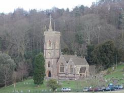
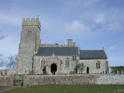
There were a couple of very nice churches on this walk. The church at East Quantoxhead was absolutely superb, and was situated marvellously in front of the magnificent Court House. Near here I could have gone to the cliff top path, but I diverted along for a short distance to see Kilve Church, which had a whitewashed tower. A service was just ending in this church so I did not go in, but next door to it was my real target; the remains of a chantry. This was just a shell, but it is the largest chantry that I have ever seen, and was built for five or six priests to live in. It was latterly used as a farmhouse, which is why it survived for so long, until a fire gutted it in the 1850's. as little further down the road by a car park was a brick tower, which was built 1924 to extract oil from the shales on this section of the coast. Unfortunately the scheme proved to be unprofitable, leaving the tower with plants growing out of the chimney.
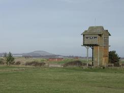
I really wanted to walk a little further today, another three miles to Combwich. Unfortunately by the time that I reached Steart my feet were aching a great deal, and so I decided to end the walk there. I met Sam at the car park, and we walked the short distance to the large bird hide at Steart Point with another couple that Sam had been talking to. This bird hide is quite an impressive structure, and marks the start of the Parrett Trail, which I shall be following for the first few miles tomorrow.
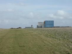
The path passed the two nuclear Hinkley Point power stations, one of the many nuclear power stations that I have passed on this trip. The last station that I passed was at Dungeness, which seems such a long way away. The old Magnox-powered Hinkley Point A station is in an ugly concrete building, whilst the newer B power station is in a much more attractive building, which unfortunately still sticks above the flay skyline like a thumb, and despite not being concrete is sadly misplaced.
Tomorrow I am faced with a little difficulty, mainly due to the fact that I did not do the extra three miles this afternoon. This means that to reach Highbridge tomorrow I will have to do a twenty-three mile day, with little chance of getting picked up before I reach Highbridge. That is a very long day, but it will be flat going and therefore I am very tempted to do it if the weather is nice. Hopefully the problems that I had with my feet will be sorted tomorrow, which will help make this more achievable.
Directions
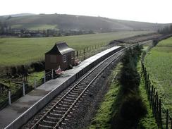
This walk starts off at the car park beside the West Somerset Railway Station at Watchet. Leave the car park and head south past the station to a road and follow the road as it climbs up to a bridge over the railway line. Cross the bridge and at the T-junction on the other side turn left and descend down to the other side of the station. Follow this road as it reaches a bridge over the railway once more, beside Doniford Beach Halt. The road continues on as it climbs uphill for more than a mile until the A39 is reached.
Turn left and walk along the A39 for a little over a mile. Pass the church at West Quantoxhead and continue on until a driveway leading down to Perry Farm is met on the left. Go down the driveway and then just before the farm is reached turn right and head uphill along a public footpath that runs along an unsurfaced track. The track continues on uphill and downhill, and when a junction with another track is met on the left turn down it and follow it as it heads uphill before ending at a bend in a road. Continue straight on eastwards down the road for about a hundred yards before a footpath is met on the left. Take this footpath and follow it northeastwards to the church beside Court House in East Quantoxhead.
Leave the church and head down through the little car park and continue straight on past the end of a pond down a track. When the track ends after a short distance continue straight on down a footpath that skirts the northern end of East Wood before crossing a field and ending at the church at Kilve, and head through the churchyard until a road is met. Turn left down this road and head past a car park and a brick tower, where the road ends. Continue on down a public footpath for a short distance until the top of the cliffs is reached.
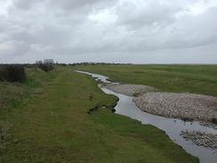
From here the directions are very easy; follow the path along the top of the cliffs until they lower in height and reach the two nuclear power stations at Hinkley Point. The path passes in front of these along a concrete sea wall and continues eastwards along a good surface until the little village of Stolford is reached. The footpath continues on along a track past Catsford Common and a little area of marshland. When the footpath veers away from the track to the right continue straight on down the track past Wall Common until it ends at a road. Join this road and walk along it for a mile into Steart, where this walk ends. I extended it by walking on northeastwards for a kilometre to the bird hide at Steart Point and back again.
Distances
| From | To | Distance (m) | Ascent (ft) | Descent (ft) |
|---|---|---|---|---|
| Watchet | Hinckley Point | 11.6 | 1388 | 1430 |
| Hinckley Point | Steart | 5.7 | 69 | 56 |
This makes a total distance of 17.3 miles, with 1457 feet of ascent and 1486 feet of descent.
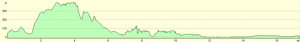
For more information on profiles, ascents and descents, see this page
Accommodation
We parked Mervan in the car park of the Anchor Inn in Combwich, who kindly let us spend the night there. In return we both had a meal there, and I had a massive and delicious full breakfast that I washed down with a pint of Old Speckled Hen.
Disclaimer
Please note that I take no responsibility for anything that may happen when following these directions. If you intend to follow this route, then please use the relevant maps and check the route out before you go out. As always when walking, use common sense and you should be fine.
If you find any information on any of these routes that is inaccurate, or you wish to add anything, then please email me.
All images on this site are © of the author. Any reproduction, retransmissions, or republication of all or part of any document found on this site is expressly prohibited, unless the author has explicitly granted its prior written consent to so reproduce, retransmit, or republish the material. All other rights reserved.
Although this site includes links providing convenient direct access to other Internet sites, I do not endorse, approve, certify or make warranties or representations as to the accuracy of the information on these sites.
And finally, enjoy your walking!
This walk was mentioned in the following routes:
| My walk around the coastline of Britain |
Nearby walks
| # | Title | Walk length (miles) |
|---|---|---|
| 92 | Porlock Weir to Blue Anchor | 14.8 |
| 93 | Blue Anchor To Crowcombe Heathfield | 12.6 |
| 94 | Crowcombe Heathfield to Taunton | 11.5 |
|
|

|