Walk #364: Bossington to Watchet
 |
 |
|
General Data
| Date Walked | 22/02/2003 |
| County | Somerset |
| Start Location | Bossington |
| End Location | Watchet |
| Start time | 09.00 |
| End time | 16.26 |
| Distance | 16.0 miles |
| Description | This was a pleasant walk, taking in the end of the South West Coast Path and points further east. |
| Pack | Today I carried my 30-litre Karrimor HotRock rucksack, which was filled with my packed lunch, waterproof leggings, water bottle and a couple of spare shirts, together with the usual assortment of odds and ends. |
| Condition | I feel absolutely fine after this walk, and have no problems to report. My ankle remains very good, with no aching that I can remember today. |
| Weather | The weather today was sunny with some broken cloud and no sign of any rain. It was quite warm compared with recent times, although there was a strong headwind that was annoying on the moorland of Bossington Hill and along the beach to Blue Anchor. |
| OS map | Landranger number 181 (Minehead & Brendon Hills, Dulverton & Tiverton) |
 |
 |
|
 |
 |
|
Map of the walk
Maps courtesy of Google Maps. Route for indicative purposes only, and may have been plotted after the walk. Please let me have comments on what you think of this new format. For a detailed table of timings for this walk, please see the table file.
 |
 |
|
 |
Notes
When I got up this morning I was faced with the prospect of doing a radio interview with BBC Radio Bristol and Somerset at about eight twenty. Sam went outside the van so that she could record the interview on the radio without any feedback whilst I talked. It was a good interview, and the interviewer seemed to be very interested in what I was doing. After this we drove Mervan to the car park in Bossington so that I could start the walk.
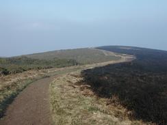
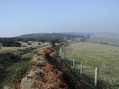
Once I had passed Bossington Hill I diverted slightly to visit the trig point at the very top of Selworthy beacon, from where there should have been some lovely views. Unfortunately the haze that has spoiled the views for the last weeks was still present, so I descended back down to the South West Coast Path and continued onwards. Mum, dad and Sam were due to be walking up from Minehead to meet me, so as I approached North Hill and the descent down into the town I expected to see them at any moment. Sam ended up ringing me, and it became clear that instead of following the South West Coast Path they had taken a lower, more seaward route, and were by the remains of the Burgundy Chapel past Greenaleigh Point. I realised that I was almost directly above them, so I took a steep and rocky footpath down the hillside that ended precisely where they were, and we all continued on down to Minehead together. Thus the end of my walk along the South West Coast Path ended up with me missing out on the last couple of miles, but I am not too disheartened by this; I had walked the last section before, and the route that I took was more seaward than the official route. It was also nice to be able to chat with the three of them as I walked.
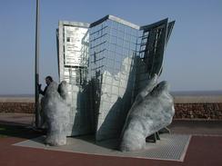
When we reached the place where Mervan was parked in Minehead Sam and I walked to the sculpture that marks the very end of the path so that some photos could be taken of my finishing the path. This was a slightly emotional moment, as it seems as if I have been on the path for the entire walk, yet in reality it has been only seven weeks. We then went back to see my parents before visiting the 'Old Ship Aground' pub for a celebratory drink. After the drink I walked into town alone so that I could visit W. H. Smiths, and then continued on the walk. Thus a day that should have been quick and easy was punctured with many stops and was much slower, but I would not have had it any other way. I also stopped very late on in the day by the pub in Blue Anchor, where I sat on the sea wall and ate my sandwiches whilst admiring the fantastic view out to sea.
Having finished the South West Coast Path I now feel that I can make some comments on it. Firstly a comment must be made about the distance walked. The National Trail guidebooks measure the distance from South Haven Point near Poole to Minehead as being 594 miles, and the South West Coast Path Association measure it as 613 miles, as they include some sections of path (such as the stint through Plymouth) that the National Trail Guides do not count as being offical trail. Tonight I have calculated that I have walked a total of around 813 miles from South Haven Point, which is 200 miles more than the official route. This is because I did not take any ferries and chose to walk up all the estuaries as far as the nearest bridge. Another fact that I found surprising is that in their suggested itinerary, the South West Coast Path Association recommend seven weeks is needed to walk the entire path, and this is about the time it took me to walk the entire path, plus the two hundred extra miles! I am quite proud of this, as essentially I gained two weeks on the recommended schedule.
Another question that occurs to me to ask is what was the best section of the path? I find this very hard to answer, but I will probably plump for the section through the army ranges at Lulworth as far as Lulworth Cove. I am unsure why this section sticks in my mind as much as it does, but I recall that I enjoyed this stretch of path immensely, and it had some fantastic scenery along it. Another question is what was the hardest section of path, and I will jointly award this to the sections from Pendeen Watch to St Ives, and from Bude to Hartland Quay. Both of these Cornish sections are tough, although I found the latter one easier than I had been expecting. The worst thing about the Pendeen Watch to St Ives leg is the terrain, which is very rough in places, although the path is distinct and navigation easy.
Tonight we stayed in a campground beside my parents' caravan, and so all of us went out for a meal in the nearby village of Bampton. This was exceedingly enjoyable and I had a nice, filling meal. After we got back we chatted for a while, and after Sam retired I remained taking to mum and dad until well after eleven, the latest I have stayed up for a long time! Long-distance walking is hardly condusive to late nights.
Directions
| During this walk I followed the South West Coast Path, the route of which is detailed in the Ordnance Survey National Trail Guide 8, Minehead to Padstow (ISBN 1-85410-774-7). Unfortunately the route description is written in reverse to the direction that I am walking, but the 1:25,000 maps in the book are clear and the signs on the ground are very good. Also to be recommended is the South West Coast Path Association guidebook (ISBN 0-907055-04-4), which has less concise directions and no maps, but includes accommodation details and grades each section of the walk according to difficulty. They also publish reverse directions, which are suitable for walking in the direction that I walked the route. They have a website at www.swcp.org.uk, which is well worth a visit. | 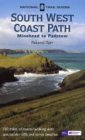
|
| 
| |
| |
| |
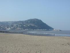
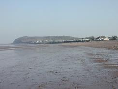
The South West Coast Path ends at a rather attractive steel sculpture of two hands holding a map by the sea front in Minehead. At the sculpture turn to head eastwards along the road that parallels the sea front, passing the West Somerset Railway Station before reaching the large and imposing Butlin's complex. Here the road ends, and a footpath continues along eastwards behind the beach, but I fond it easier to walk actually along the beach itself. Pass Dunster Beach before you eventually reach the railway station at Blue Anchor.
From Blue Anchor Station either follow the beach along eastwards or walk along the footpath beside the B3191 road. If the tide is very low it may be possible to walk along the beach all the way to Watchet; I did not want to risk it, however, so I took a cliff top route. When the road curves to the right to head uphill past the Blue Anchor pub follow it uphill. The map shows a footpath leading off to the left a few hundred yards past the pub; this path is now shut, so carefully continue along the road for another quarter of a mile and then take a permissive footpath that leads off to the left, descending downhill through woodland before reaching the cliff top. When the cliff top is reached, turn right and follow the edge of the cliffs uphill through the woodland.
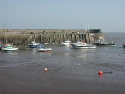
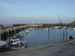
The path emerges out of the woodland and crests a hill before descending down and plunging into another area of woodland. Near the bottom of the hill when the footpath turns away to the right to head back towards the road, continue straight on along a permissive footpath along the edge of the cliffs that ends by the road at Daws Castle. Join the road and carefully walk down it into the town of Watchet. Pass the harbour and follow the road as it curves to the right. The railway station, where this walk ends, is a few hundred yards away on the left.
Distances
| From | To | Distance (m) | Ascent (ft) | Descent (ft) |
|---|---|---|---|---|
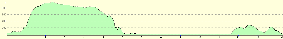
| Bossington | Minehead (end of SWCP) | 7.6 | 1483 | 1496 |
| Minehead (end of SWCP) | Watchet | 8.4 | 748 | 768 |
This makes a total distance of 16.0 miles, with 2231 feet of ascent and 2264 feet of descent.
For more information on profiles, ascents and descents, see this page
Accommodation
We stayed at the Waterrow Touring Park, Wiveliscombe, Taunton TA4 2AZ. They can be contacted on (01984) 623464 or by email at taylor@waterrowpark.u-net.com, and they have a web presence at www.waterrowpark.u-net.com. We are unsure how much this site cost us as my parents paid the fee, but we believe that it was in the order of eight pounds. The bathrooms were nicely heated, and all in all this was not a bad site, although it was a reasonable distance from the coast.
Disclaimer
Please note that I take no responsibility for anything that may happen when following these directions. If you intend to follow this route, then please use the relevant maps and check the route out before you go out. As always when walking, use common sense and you should be fine.
If you find any information on any of these routes that is inaccurate, or you wish to add anything, then please email me.
All images on this site are © of the author. Any reproduction, retransmissions, or republication of all or part of any document found on this site is expressly prohibited, unless the author has explicitly granted its prior written consent to so reproduce, retransmit, or republish the material. All other rights reserved.
Although this site includes links providing convenient direct access to other Internet sites, I do not endorse, approve, certify or make warranties or representations as to the accuracy of the information on these sites.
And finally, enjoy your walking!
This walk was mentioned in the following routes:
| My walk around the coastline of Britain |
| South West Coast Path |
Nearby walks
| # | Title | Walk length (miles) |
|---|---|---|
| 91 | Lynton to Porlock Weir | 13 |
| 92 | Porlock Weir to Blue Anchor | 14.8 |
| 93 | Blue Anchor To Crowcombe Heathfield | 12.6 |
|
|

|