Walk #93: Blue Anchor To Crowcombe Heathfield
 |
 |
|
General Data
| Date Walked | 02/05/2000 |
| County | Somerset |
| Start Location | Blue Anchor |
| End Location | Crowcombe Heathfield |
| Start time | 09.30 |
| End time | 16.20 |
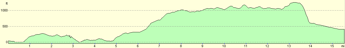
| Distance | 12.6 miles |
| Description | This was a lovely walk, much of which was ridge walking along the Quantock Hills. |
| Pack | Today I carried my Craghoppers WP70 rucksack, without tent, sleeping bag or trangia. |
| Condition | After this walk I feel fatigued but resilient. My right ankle continued to give me some occasional gip, and I have developed a small but nasty blister on the side of the middle toe on my left foot. This is right beside the nail, so it may not be a blister but a place where the nail has been forced into the skin. |
| Weather | Today was virtually identical to yesterday, with bright sunshine and a slight wind. It was probably a few degrees cooler than yesterday, however, and slightly cloudier. All in all it was perfect walking weather. |
| OS map | Landranger number 181 (Minehead & Brendon Hills, Dulverton & Tiverton) |
 |
Map of the walk
Maps courtesy of Google Maps. Route for indicative purposes only, and may have been plotted after the walk. Please let me have comments on what you think of this new format. For a detailed table of timings for this walk, please see the table file.
Notes
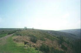
A spectacular second half of the day walking the ridge of the Quantock Hills was preceded by a relatively boring but pleasant road walk to West Qnantoxhead.
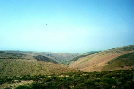
The highlight of the walk was the ridge walk along the Quantocks. The highest point of the Quantock hills is Wills Neck at 284 metres, and this was also the highest point on my journey so far. The whole of the ridge walk was lovely, although there was a haze in the distance that meant that wide, panoramic views were not available.
Since the YHA did not open until 17.00 I took my time over the walk and visited a couple of Trig points that were not directly on my route.
I now only have a 10-mile hike into Taunton to complete before this little adventure is finished. This time tomorrow night I shall be snug and warm in my own bed, dreaming of my next trip. It is always a bit of a culture shock getting back to civilisation, and I must admit that work seems like a different world, and the thought of going back is not exactly awe-inspiring.
On the steep ascent up to the Quantock ridge I met an old lady called Dorothy, who was also visiting the Crowcombe Heathfield YHA that night. We spent a fair while chatting about the local flora and fauna - I have far from a comprehensive knowledge of such things, so it was very nice to talk to someone who had such comprehensive knowledge.
All in all this was a highly enjoyable day, with even the road walk up to the start of the Quantocks being quite nice. I think the thing that I liked most was the fact that the scenery was not coastal, but high moorland of the sort that I am more used to. At times when I was in the Quantocks I even believed that I could have been in the Pennines.
Directions
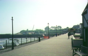
From Blue Anchor station head east along the seafront following the B3191 road. Follow the road as it veers away from the sea for a couple of miles eastwards to Watchet Station.
Head uphill from Watchet Station and turn left down a minor road that takes you eastwards past Doniford Beach Halt and hen up a hill to meet the A39. Cross the A39 and then head into West Quantoxhead.
Go through the village and head uphill along a road that passes Staple Plantation. Halfway up the hill the road ends in a car park, and a track continues straight on up the hill. Once the top of the hill is reached and the gradient starts slacking off, a path to the left can take you a short distance to a 310 metre trig point. If you do not want to visit it, then a path to the right will take you south along the ridge of the Quantock hills.
Follow the ridge southwards and then southeastwards as it passes Thorncombe Hill and Hurley Beacon. There are several places where other tracks lead off from the main one, so take compass bearings to ensure you follow the correct one. At Hurley Beacon you can choose to either turn right to visit the tumulus at the Beacon, or alternatively turn left and visit a 358 metre trig point. Both of these are short distances away from the main path.
The path continues southeastwards until it finally comes to a car park at Crowcombe Park Gate. Cross this road and continue southeastwards through some National Trust land to a car park beside the Triscombe Stone, an item of some antiquity. Cross the road at the entrance to the car park and follow the track as it heads up to the 384 metre trig point at Wills Neck. This is the highest point of the Quantock Hills, and should give marvellous views if the weather is fine.
Leave Wills Neck by a path that heads westwards down the hill. This is a very steep descent, and is a classic case of where walking poles or sticks come in useful. At the bottom of the hill turn right past a public house at Triscombe and then left to head southwestwards for a kilometre until you reach the A358. Cross the A358 and head for another kilometre until you reach the YHA at Crowcombe Heathfield. Shortly before the YHA the road cross over the West Somerset Railway line, and Crowcombe station is a short distance away to the north.
Distances
| From | To | Distance (m) | Ascent (ft) | Descent (ft) |
|---|---|---|---|---|
| Blue Anchor | Watchet | 3.5 | 525 | 518 |
| Watchet | Beacon Hill | 4.6 | 1145 | 197 |
| Beacon Hill | Crowcombe Heathfield | 4.5 | 807 | 1407 |
This makes a total distance of 12.6 miles, with 2477 feet of ascent and 2122 feet of descent.
For more information on profiles, ascents and descents, see this page
Accommodation
I stayed at Crowcombe youth hostel, Crowcombe Heathfield, Taunton, Somerset TA4 4BT, telephone (01984) 667249. The youth hostel is at Ordnance Survey Grid Reference ST138339.
For more details of suitable accommodation in this area, please see the South West Coast Path Association's Annual handbook.
Transport
The West Somerset Railway run train services between Blue Anchor and Crowcombe stations for much of the year. These trains also call at Watchet and Doniford Beach Halt on the first section of this walk.
Disclaimer
Please note that I take no responsibility for anything that may happen when following these directions. If you intend to follow this route, then please use the relevant maps and check the route out before you go out. As always when walking, use common sense and you should be fine.
If you find any information on any of these routes that is inaccurate, or you wish to add anything, then please email me.
All images on this site are © of the author. Any reproduction, retransmissions, or republication of all or part of any document found on this site is expressly prohibited, unless the author has explicitly granted its prior written consent to so reproduce, retransmit, or republish the material. All other rights reserved.
Although this site includes links providing convenient direct access to other Internet sites, I do not endorse, approve, certify or make warranties or representations as to the accuracy of the information on these sites.
And finally, enjoy your walking!
This walk was mentioned in the following routes:
| My sectional Land's End to John O'Groats walk |
Nearby walks
| # | Title | Walk length (miles) |
|---|---|---|
| 92 | Porlock Weir to Blue Anchor | 14.8 |
| 94 | Crowcombe Heathfield to Taunton | 11.5 |
| 364 | Bossington to Watchet | 16.0 |
|
|

|