Walk #631: A circular walk from Cropredy
 |
 |
|
General Data
| Date Walked | 20/11/2004 |
| County | Oxfordshire, Warwickshire, Northamptonshire |
| Start Location | Cropredy |
| End Location | Cropredy |
| Start time | 08.52 |
| End time | 14.36 |
| Distance | 17.8 miles |
| Description | This was quite a varied walk, with a nice if muddy canal side walk followed by a long stroll back along quiet roads. |
| Pack | Today I carried my 30-litre Karrimor HotRock rucksack, which was filled with three litres of water, a spare fleece, waterproofs and various electronic gadgets. |
| Condition | For the last few miles of the stroll I had pain in the little toe of my right foot; when I got back to Cambridge I discovered that it had been bleeding; a symptom of not having cut my toe nails. Aside from this I feel fine, and the underside of my feet do not hurt too much. |
| Weather | The day started off cloudy and with no rain; however shortly after I left the canal a light drizzle started falling. This was not heavy enough for me to put my coat on, and so I let my thick fleece soak it up. Fortunately after a couple of hours this stopped, only to restart in heavier form about ten minutes before I reached the end of the walk. It was quite a cold day, and there were still isolated patches of snow and ice left from Thursday's snowfall. |
| OS map | Landranger number 151 (Stratford-upon-Avon, Warwick & Banbury) |
 |
 |
|
 |
 |
|
Map of the walk
Maps courtesy of Google Maps. Route for indicative purposes only, and may have been plotted after the walk. Please let me have comments on what you think of this new format. For a detailed table of timings for this walk, please see the table file.
Notes
I decided to do another little walk along the Oxford Canal today, settling on the section of canal between Cropredy and Wormleighton. This was by far the hardest section to plan, as there is sparse public transport in the area and it was not obvious how I could create a good circular walk. In the end I decided to forget public transport and make a complete circuit by using roads, hoping that the villages that I would pass would more than make up for the road walking. I therefore found myself getting up early and driving westwards for two hours to reach the village. As I neared Cropredy along the A361 I was disappointed to see that the stream (a tributary of the River Cherwell) was in flood; this affected the latter part of the day's route.
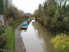
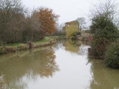
I had never been to the village before, and so I spent some time finding a nice place to park. In the end I decided on a spot near the chapel in the village, and I walked along small roads past the church and some pretty little thatched cottages and the Red Lion pub to reach the canal by a lock. This lock was dewatered and under repair, with tower scaffolding rising up from the bottom floor. I was curious to find out what work was being done, and I found a small sign stating that the lock gates were being replaced after twenty years. This unnerved me slightly, as on occasion in the past I have been forced to detour away from towpaths due to canal works, and I hoped that I would not come across any more during the course of the walk. I soon realised that the water was muddy after all the rain, and this made for some great reflections in the water; at one stage I saw two swans on the water, and their mirror images in the brown water were far more distinct than they would have been on clear water on a sunny day.
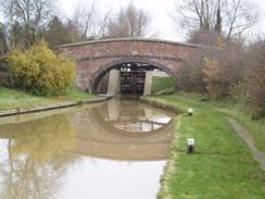
The morning was quite cold, and I was soon searching in my breast pocket amongst a jumbled hoard of batteries, chocolate bars and a compass to find my woolly hat. Once I had put it on I was much warmer, and I continued on along the towpath, listening to the CD walkman that I had bought the previous week. Although there were some narrow boats tied up against the side of the canal there were no boats moving (probably due to the lock in Cropredy being repaired), and I found the walk to be more boring than usual. Over to my right there were flooded fields, and I soon passed a culvert that was allowing a torrent of overspill water from the canal into an already flooded field. More locks passed before I reached the five locks of the Claydon Flight, and I took several photos of each of these before continuing on along the canal.
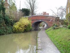
After passing the abutments of an old railway bridge I reached a section of the canal called The Tunnel. At first sight this was a strange name as there was just a deep cutting, but the explanation came shortly afterwards on an information board - originally there were two short brick tunnels separated by a gap of 155 yards. These tunnels were opened up into the present-day cutting in 1868 and 1870, leaving only the name as sign that the tunnel once existed. Over the cutting was a large road bridge carrying the A423(T) road over head, and next to this was a far more picturesque footbridge, because the towpath stopped following the eastern bank of the canal and swapped over to the western bank. This made a nice change, and I enjoyed the short stroll to Fenny Compton Marina, and on around the bend to Fenny Compton Wharf and the Wharf Inn.
The idea of going into the Wharf Inn for a quick drink was extremely tempting, but it was not due to open for a quarter of an hour and I did not want to wait in the cold, so I strode on under the bridge, singing the words to a rather dubious song that was playing through my headphones. I started singing the strap line to the Momus song 'The Homosexual', just as a couple came striding towards me from under the bridge. I stopped singing mid-word, and in a typically English way eyes were averted before I shuffled on under the bridge, cursing my luck at starting singing just as I encountered the only two other walkers I saw on the towpath! To overcome my embarrassment I put a burst of speed on that soon took me around the curving canal towards the prominent Wormleighton Hill, which the canal curves around three sides of.
Here I came across a simple footbridge made out of a large wooden beam, but it was so bent and warped I was surprised that it had not fallen down. I stopped for a couple of minutes and studied it more closely, and the more I did so it became obvious that the beam, although warped, was still structurally sound. I was, however, determined not to test the theory and walked on the short distance to Bridge 131, where I had joined the canal on a previous walk. A short track led down to the A423(T) road, and I walked south along the verge of this avoiding the heavy traffic before following a bridleway across fields. By Wormleighton Grange Farm I came across an exceptionally boggy section that took me a few minutes to negotiate; by the time that I reached the gate I found that I could not undo it, so I climbed over and fortunately found that the ground on the other side was far firmer.
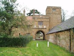
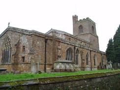
There were still some muddy section as I headed across to Bridge 133 on the canal, which I crossed and then climbed uphill and descended slightly to the church at Wormleighton. This church was initially built in the twelfth century, but the village was deserted at the end of the fifteenth Century. The present village dates from Victorian times, and is owned by the Spencer family. From the church I descended down past an attractive Manor House, and near this was a beautiful archway, almost hidden away between buildings. I studied this for a short period before continuing on and starting the long stretch of road walking. My first target was Lower Boddington, about two and a half miles away. The firs stretch of road was reasonably quiet, but I was glad when the road forked and I took a quieter one past Stella House and into the village.
The only thing of interest I could find in the village was the pub, but I managed to ignore the urge to go in for a quick half and continued on, cursing the light drizzle that had been falling for some time. This was not heavy enough for me to put my coat on, and as I was within a couple of hours of the end I was not too bothered; if I was on a multi-day hike I definitely would have put it on. The drizzle finally peered out as I entered the little village of Aston le Walls, and I paused for a couple of minutes by St Leonards Church. This was quite picturesque with the war memorial replete with recently-hung wreaths to the fallen. I walked on further along the road as it passed an old airfield and reached the farm at Appletree. The road soon started to descend downhill before reaching the stream and canal once more near lock 24.
There were signs of the recent heavy rains everywhere, from flooded fields to a hastily-made barricade around the entrance to a house by the stream. It was another picturesque sight, but the drizzle was starting to fall once again as I headed along up a slight hill. The drizzle became heavier and soon became rain, but as I was so near the end I decide not to pause to put on my coat. I was fairly drenched as I entered Cropredy and followed the road as it curved around through the village, and eventually I reached bridge 153 over the canal by a little Spar shop.
I resisted the temptation to go in and buy chocolate (my diet having allowed me to lose some of the weight that I had gained over recent emotional travails), and continued back along the canal for a short distance to the lock where I started the walk. It was a short stroll back to the car, where I could finally get my wet fleece off and warm myself up. I drove back reflecting on a walk that had hardly been classic, but was enjoyable and fulfilling nonetheless.
Directions
This walk starts off at Lock 24 and the adjacent Bridge 152 on the Oxford Canal, which is situated in the middle of the village of Cropredy. Walk northwards along the towpath of the canal that runs on the eastern side of the canal for five miles until the bridge that carries the A423(T) road over the canal at The Tunnel. Immediately after the bridge an elegant footbridge over the canal is reached; cross this and continue along the towpath on the other side of the canal for another three and three-quarter miles, passing Fenny Compton Wharf before eventually reaching Bridge 131 on the western edge of Wormleighton Hill. Immediately before Bridge 131 turn left up some steps to the lane that goes over the bridge, and then continue on for a few yards until the A423(T) is reached.
Turn left and head south along the A423(T) for about a hundred yards; the road is quite busy and so you may want to walk along the wide verge. When a gate is reached on the left go through it and follow a bridleway that heads southeastwards along a hedge. The bridleway skirts Wormleighton Grange Farm where the hedge ends, and continues on to cross the canal at Bridge 133. The bridleway then climbs up a short hill before curving to the right to reach a track beside a farm; on this section of the bridleway the path sticks to field boundaries and does not head off across fields. At the track turn right and start following is as it heads downhill to the south, passing Wormleighton Church and the manor house before reaching a road junction. Here turn left, and follow a road eastwards that after a kilometre crosses the Warwickshire / Northamptonshire border; here the road curves to head southeastwards.
Shortly after this when the road forks take the right-hand fork, and follow this road as it heads southeastwards, passing Spella House before continuing on into Lower Boddington. Pass through this village and the head on southeastwards for another mile and a half until the road starts to climb up a hill and enters the village of Aston le Walls. When a road junction is reached on the right at the top of the hill turn right, and follow this road as it curves around through the small village, passing the church before leaving the village. The road curves onto a southwesterly course as it skirts the edge of an old airfield, until suddenly a sharp right-hand bend is reached. Go around the bend and follow the road for another hundred yards until it ends at a T-junction near Appletree Farm.
At the T-junction turn left and follow this new road as it heads southwards. After a mile the road curves to the right, eventually crossing Highfurlong Brook to reach Broadmoor Lock (no. 24) on the canal. Continue on westwards along the road for another few hundred yards until the road ends at a T-junction. At this junction turn left and follow the road southwards for a little over a kilometre into the village of Cropredy, and then as it curves to the left follow it until a large junction is reached. Here turn left and follow the road eastwards downhill to a bridge over the canal near a little Spar shop. Cross the bridge, and then drop down to the left and follow the canal towpath along the eastern side of the canal northwards for a couple of hundred yards until Bridge 152 and Lock 24 is reached, where this walk ends.
Update April 2010: A correspondent has just warned me that the bridleway by Wormleighton Grange Farm has been blocked with fencing, a padlocked gate and an electric fence. It may be possible to avoid this stretch by continuing along the canal from Bridge 133 and then rejoining the bridleway to the northwest of Wormleighton. Note I have not walked this diversion, so I do not know how possible it is.
Distances
| From | To | Distance (m) | Ascent (ft) | Descent (ft) |
|---|---|---|---|---|
| Cropredy | Wormleighton | 9.9 | 425 | 256 |
| Wormleighton | Cropredy | 7.9 | 267 | 436 |
This makes a total distance of 17.8 miles, with 692 feet of ascent and 692 feet of descent.
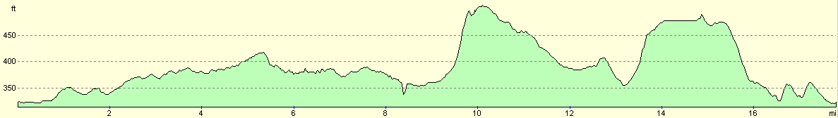
For more information on profiles, ascents and descents, see this page
Disclaimer
Please note that I take no responsibility for anything that may happen when following these directions. If you intend to follow this route, then please use the relevant maps and check the route out before you go out. As always when walking, use common sense and you should be fine.
If you find any information on any of these routes that is inaccurate, or you wish to add anything, then please email me.
All images on this site are © of the author. Any reproduction, retransmissions, or republication of all or part of any document found on this site is expressly prohibited, unless the author has explicitly granted its prior written consent to so reproduce, retransmit, or republish the material. All other rights reserved.
Although this site includes links providing convenient direct access to other Internet sites, I do not endorse, approve, certify or make warranties or representations as to the accuracy of the information on these sites.
And finally, enjoy your walking!
Nearby walks
| # | Title | Walk length (miles) |
|---|---|---|
| 162 | Braunston to Leamington Spa | 16.6 |
| 598 | A circular walk from Badby via Lower Shuckburgh | 21.4 |
| 625 | A circular walk from Southam | 22.2 |
|
|

|