Walk #863: Wareham to Swanage
 |
 |
|
General Data
| Date Walked | 21/07/2010 |
| County | Dorset |
| Start Location | Wareham car park |
| End Location | Swanage station |
| Start time | 08.42 |
| End time | 16.38 |
| Distance | 19.9 miles |
| Description | This was a great and varied walk, initially following the western side of Poole Bay, before joining the first few miles of the South West Coast Path. |
| Pack | Today I carried my 30-litre Karrimor rucksack, filled with water, my waterproofs, a couple of books and other odds and ends. |
| Condition | I feel fine after this walk. |
| Weather | Today's weather was a mixture of sunshine and cloud. Fortunately the cloud helped keep the temperature down somewhat. There was also a brisk breeze at times. |
| OS map | Landranger number 195 (Bournemouth & Purbeck, Wimborne Minster & Ringwood) |
 |
 |
|
Map of the walk
Maps courtesy of Google Maps. Route for indicative purposes only, and may have been plotted after the walk. Please let me have comments on what you think of this new format. For a detailed table of timings for this walk, please see the table file.
 |
 |
|
Notes
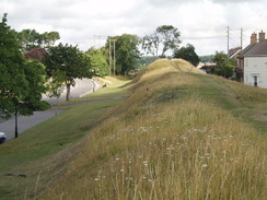
This walk was the next part of my aim to re-walk the south coast in sections. On Monday I walked from Poole to Wareham; now I only had a section to do from Wareham to South Haven Point to connect it up with walks I had done previously. Instead of ending at South Haven Point, which would have meant a short day, I decided to extend the walk by following the South West Coast Path to Swanage, which is always a pleasurable stretch of coast to walk. I arrived at Wareham later than I expected due to the usual traffic queues near Wimborne, and then found it difficult to find long-stay parking. Eventually I found the long-stay car park nestled below the banks of the town walls.
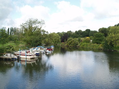
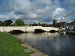
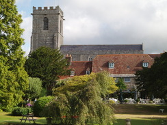
I quickly got my kit together and headed off through this beautiful little town. It is a perfect little place that seems ageless - perhaps due to its Saxon origins. I headed down the main road to reach South Bridge. The path I followed ran along the southern bank of the river, initially with some pleasant views across it towards the quay and church. Immediately to the right was a Community Performance Platform , which is something that I have never seen before. Rows of boats lined the river banks, showing what a popular location this is for boaters, and the view across the river to the Priory church was superb.
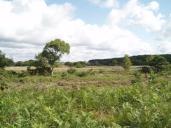
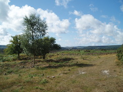
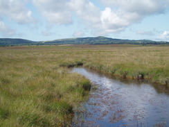
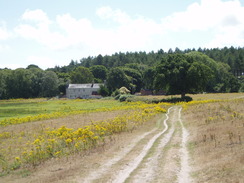
The path did not stay with the river bank for long; it passed a yacht club before reaching Redcliffe (obviously named after the large red cliff that rose on the outside of the river bend). Here the path leaves the river bank and climbs up to the aptly-named village of Ridge, which sits on the high ground above the river. It took a few minutes to negotiate my way out of the village, but what followed was a superb walk eastwards along the road that leads towards Arne Point. Although there were only fragmentary views over towards Poole Bay, the other views were brilliant, with heather-clad hills rising to the right and moorland reaching to the bay on the left. I spooked some deer off to the right, and they ran away, paralleling the road.
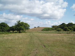
The road rose to a summit where, unexpectedly, some views of the ruinous Corfe Castle became visible in the distance to the right, standing proud on its hill in the centre of a gap in a ridge. Corfe Castle is rightly famous, and I was surprised to see exactly how close it is. This stretch of coast is never more than a few miles away from the castle, but never approaches it. I reached Sharford Bridge over the River Corfe, which unfortunately was overgrown with summer vegetation. By this point I was in a very good mood; a superb morning's walk had raised my spirits.
Some tents, marquees and two rows of Portaloos were arrayed in the field to the right. I walked on, looking for the footpath that would head eastwards. I went past a gate and continued on to a barbed wire fence. An obvious path ran along the other side of the fence, so I clambered over and started along. It soon became clear that the path was overgrown and I frequently had to duck under branches. After five minutes of clambering I was sweating heavily and I realised that my old faithful dicataphone had fallen off my pack. I threw my pack onto the ground and started heading back through the trees to look for it. I reached the place where I had crossed the fence and it was not there, so I headed back, finding it laying on the ground only about fifty yards from my pack. All of the clambering around made me feel very sweaty, hot and frustrated, and had removed much of the enjoyment I had gained from the day so far.
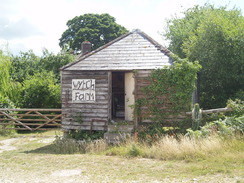
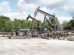
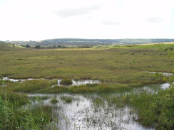
The next couple of miles were far from enjoyable. I passed through Wytch Farm, and then passed a couple of nodding donkeys of an oil well, only one of which was working. A couple of lorries from a company based in Aberdeen headed off as I arrived; Aberdeen being Britain's major oil area. The Wytch Farm wells are operated by BP, who are under a great deal of pressure at the moment due to the Gulf oil leak. This oil well, however, was hardly a blot on the landscape; it was well masked by trees and only a low hissing sound could be heard a hundred yards away. It is an example of how oil extraction need not be a messy, polluting process.
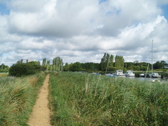
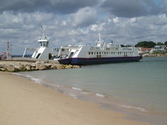
A series of unenjoyable paths and tracks led me eastwards. A crane appeared to be erecting an oil derrick somewhere on Goathorn Point, and there was a fully-erected derrick somewhere further to the north; perhaps exploratory drilling to do with a newly-found reservoir? It was a relief when I finally reached the Ferry Road. I headed north towards South Haven Point, which marks not only the start of the South West Coast Path, but also the chain ferry that takes traffic over the mouth of Poole Harbour to Sandbanks.
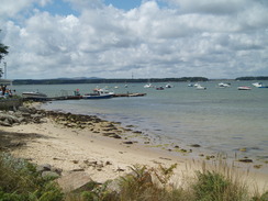
Poole Harbour has served a very good purpose in stopping westwards development; the coast spreading east from Sandbanks is heavily developed, whilst that westwards is a very different - and quieter - beast. The traffic came towards me in burps as the ferry docked on this side of the harbour mouth, but for the rest of the time it was thankfully quiet.
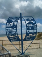
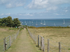
The Shell Bay restaurant and bar is on the left just before the ferry, and this seemed as good a place as any to have a break. I nipped in and ordered my usual: a pack of crisps, a pint of bitter and another of orange and lemonade. The views over Poole Bay from the restaurant were superb, but instead I sat out at the front, watching the traffic stream past off the ferry. I took my boots off and allowed them to cool down a little. Time flew, and what I thought was only ten minutes turned out to be half an hour, so I put my boots back on and hurried to the sculpture that marks the start of the South West Coast Path. A ferry was disgorging its load of vehicles, but my way led along the South West Coast Path.
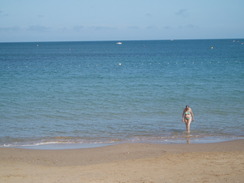
The two previous times I had walked along this stretch had been early in the year, and I was surprised to see how much busier the beach was; lots of windbreaks had been installed and people were swimming in the sea. A speedboat trailing two red flags went past, heading towards the point; as it did so, the ice-cream tune blared out. Another flag showed that the flags were those of Wall's ice cream, and that it was an ice cream boat - a great idea. (Last year an ice cream boat and a yacht both collided with the chain ferry within a few minutes of each other.
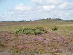
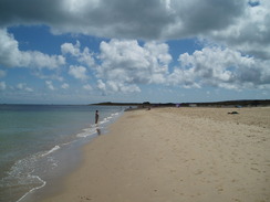
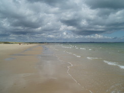
There was plenty to see as I strolled along, a vast difference to the nearly deserted beaches that I had seen before. Plenty of boats were hurrying around out at sea, and the beaches themselves were busy. The breeze turned into an annoying headwind that I could have done without. Part of Studland Beach is famously a naturist beach, and it seems like they prefer the summer sun to winter winds, and there were many people letting it all hang out. I shared a few polite nods with some as I walked past, not knowing quite where to look. I must admit that for a minute I considered taking all my clothes off and running into the sea Reggie Perrin-style, but I still had some miles to walk and had no towel.
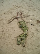
A National Trust van was selling ice creams to the naturists, and further on someone had created a picture of a mermaid in the sea, with seaweed for a tail. The beach became more crowded as I headed south and left the naturist beach, with many families out and about. Many were making sandcastles, but they were more like sand forts than castles, vast sprawling complexes with towers and walls.
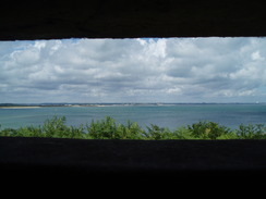
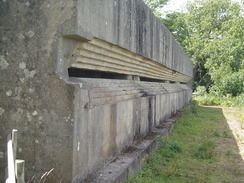
I stopped off at the beach restaurant to buy an ice lolly to help me cool down, and then headed on southwards. I passed the large concrete pillbox at Fort Henry Bunker which, as usual, I had to enter to explore, even if it was hard to pass the interior dividers with my pack on. Outside there is a memorial to some men who died on an exercise here in 1944. After this I was left with a choice; there is a low-level route along the beach that I had walked before, so instead I took the high-level route, which headed into the village of Studland itself. A wonderful smell of hops swept over me as I passed the pub; it is also a micro brewery. The pub garden was packed, and I found myself wishing that I could join them.
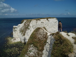
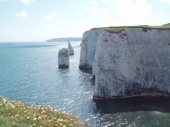
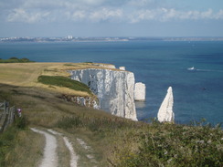
Old Harry Rocks were as impressive as ever in the sunshine, the chalk glinting and seemingly pure white. The Needles and the cliffs of the Isle of Wight glinted in the distance. I did not dare go to the very outermost point of the path (a mixture of sanity, cowardice and rubbery legs preventing me), and instead contended myself with taking photographs. Nearby are a couple of other stacks called the Pinnacles. It is truly a marvellous location.
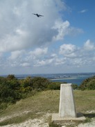
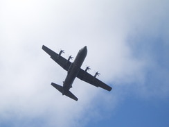
The next stretch of paths continued the climb, during which a large cargo plane flew directly overhead. It did a series of loops, allowing me to get some beautiful photos of it as it headed right over the trig pillar. I had no idea what they were doing, but it was a very impressive display. It continued as I headed down, following the now-familiar route through the northern outskirts of Swanage.
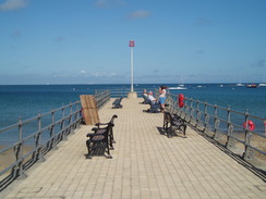
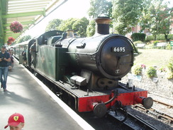
I was starting to feel a little tired as I walked along the promenade through Swanage. Despite this I was tempted to continue on and walk around Peveril Point, but time was pressing. Instead I nipped into the TI office and asked them for directions to the bus station. This turned out to be in the forecourt of the Swanage Railway station. It turned out that there was half an hour before the next bus, so I nipped into the station to watch as a GWR tank engine arrived at the station. It was a great end to what had been - with one exception - a great day"s walk. The Swanage Railway have plans to extend their line from the current terminus at Norden into Wareham using the existing freight-only line; if this comes about then it would make a superb climax to this walk. Instead, I had to use the bus.
The return bus journey was interesting. It was busy (only to be expected at the end of a working day), and I sat on the top deck as it headed up and down the steep hills to the west of Swanage. As it headed down a steep series of switchbacks I found myself muttering the self-preservation society'. Fortunately everything was fine and we soon arrived back in Wareham.
 |
 |
|
Directions
This walk starts off from the long-stay car park in Wareham, situated just off Streche Road , which leads off West Street. Pass the bank of the town walls and head up to West Street, and then turn left to head eastwards to the crossroads by the Red Lion Hotel. At the crossroads turn right to head south through the town. After a short distance the Quay is reached, and South Bridge.
Cross South Bridge and then turn left to immediately join a footpath on the left. Head eastwards along the southern bank of the River Frome. When it reaches Redclyffe Yacht Club continue straight on along a track; as the track follows the river around to the left, continue on half-right along another track that heads uphill, following the Purbeck Way. This track ends at a road in Ridge. Leave the Purbveck Way and turn left to head eastwards. When a dead-end sign is reached, turn right to head south along Sunnyside Road.
This road soon ends at a T-junction with another road. Turn left along this road and start following it eastwards towards Arne. After a mile a road junction is reached at SY954864. Turn right and start following the road southeastwards (signposted for Corfe Castle). The road passes Slepe Farm and curves to take a more southerly direction. Just before some stone gateposts are reached at SY961847 turn left along another footpath. This almost doubles back on itself; when some trees are soon reached the path turns right to enter the trees, heading southeastwards. A stile is reached; cross this to reach Sharford Bridge over the small River Corfe.
Cross a stile on the other side of the bridge and then turn left to head north alongside the river on the left. Keep a little hillock on the right, and when a fence is reached follow it eastwards to a gate in the corner of the field. This joins a track that initially heads eastwards before curving slightly to the right. As it curves to the left once more turn left to walk up a field, with a fence on the right. At a gate turn right to go through the gate, and walk straight across the field eastwards to reach SY971853. When the eastern edge of the field is reached, turn right to follow the hedge southeastwards for a few yards.
When a track is reached on the left, join it and follow this as it curves around in a rough easterly direction to reach Wytch Farm. Walk straight through the farm and then turn right along another track. This curves around to head southwards; the track ends as it emerges from the trees and keep the trees to the right as you head south to a gate. Go through the gate to reach a surfaced road.
The footpath arcs away to the south; this can be missed by turning left and following the tarmac road eastwards, with an oil well to the left. When the track curves to the right at SY982852 turn right down another track. This is fairly obvious at first as it curves around, taking a roughly easterly course. At SY990850 another track is reached. Turn right to head southeast down this track for a few yards, and then turn left to join a footpath that cuts eastwards through the trees. Due to the nature of forestry paths, the actual path headed slightly south of those on the map.
The path emerges out onto another track. Turn left to start heading northeastwards along this track. It becomes concrete and drops down to cross a stream; it then climbs up the other side. Head straight on at a crossroads in the tracks and continue on for a few yards to the top of the hill. Turn right to join another footpath that heads eastwards, before curving to head in a more southeasterly course. It passes to the right of a cottage at Newton and continue southeastwards. It meets a track that can be followed eastwards towards Goathorn Farm.
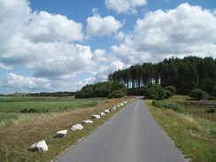
The track curves to the south of the farm, before heading southeastwards towards Greenlands Farm. It curves to the south of this farm as well, before settling on a more easterly course. The track eventually ends at Ferry Road at about SZ025843. Turn left and start following Ferry Road northwards for nearly two miles. On the way it curves to the right to take a more northeasterly course, eventually ending at South Haven Point.
This marks the start of the South West Coast Path. From the large blue sculpture marking the starting point, turn right and start following the beach southeastwards along Shell Bay. Round the point, and then start heading south along Studland Beach. Continue on for one and a half miles. At Middle Beach the path leaves the beach and turns to the right to head steeply uphill along a road. Just before a stone building is reached on the left (and a car park on the right), turn sharply to the left to follow the SWCP through the trees. It joins the cliffs, passing the Fort Henry Bunker.
Shortly after this at SZ039826 there is a choice; if the tide is low you can descend to the beach and follow this for a short distance southeastwards. If not, then you can turn right to follow a path southwestwards into the village of Studland itself. When a road is reached turn right and follow it downhill, passing a pub on the right. When the public toilets are reached on the left, turn left and start heading uphill along a track. This heads eastwards, climbing uphill for a mile until Handfast Point is reached. Just off the coast here is Old Harry Rocks.
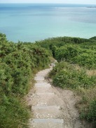
Here follow the cliff edge as it turns sharply to the right to head southwestwards towards Ballard Point, keeping the sea to the left. It continues climbing as it curves to head westwards, reaching a summit just below a trig pillar. Do not take the track that heads uphill to the west and along Ballard Down. Again follow the path nearest to the cliff edge (although not too near), as it turns to the left to head downhill to the southwest. Some steep steps soon lead you downwards before the gradient slackens.
Steps lead down to, and out from, a steep sided valley. A path leads to the left from this valley towards the northern edge of the beach; at low tide the beach can be followed into Swanage. Otherwise climb out of the valley and continue on across a small area of parkland. Turn half-right to reach a tarmac path, and follow this westwards until it ends at a T-junction with a road. Turn left to head south along this road, and follow it as it swings to the right to head westwards once more. The road joins a larger road; when it ends at a T-junction at SZ029802 turn left and start following the road downhill to the south.
This meets the northern end of the promenade. Continue southwards along the promenade, passing the tourist information office until the theatre is reached. Here the South West Coast Path is left; turn right to head inland towards Swanage Railway Station (a preserved line). The bus station is on the left, in the station forecourt.
 |
 |
|
Distances
| From | To | Distance (m) | Ascent (ft) | Descent (ft) |
|---|---|---|---|---|
| Wareham | Wytch Farm | 5.3 | 200 | 230 |
| Wytch Farm | South Haven Point | 6.2 | 174 | 177 |
| South Haven Point | Swanage station | 8.3 | 1598 | 1581 |
This makes a total distance of 19.9 miles, with 1972 feet of ascent and 1988 feet of descent.
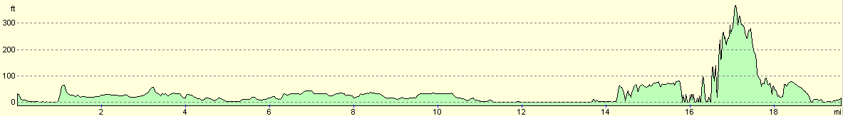
For more information on profiles, ascents and descents, see this page
Transport
There are hourly bus services on the number 40 route running between Swanage and Wareham. The bus stop in Swanage is outside the railway station, and it stops at South Bridge in Wareham and at the Red Lion Hotel in the centre of the town.
 |
 |
|
 |
 |
|
 |
 |
|
 |
 |
|
 |
 |
|
 |
 |
|
 |
 |
|
 |
 |
|
 |
 |
|
 |
 |
|
 |
 |
|
 |
 |
|
 |
Disclaimer
Please note that I take no responsibility for anything that may happen when following these directions. If you intend to follow this route, then please use the relevant maps and check the route out before you go out. As always when walking, use common sense and you should be fine.
If you find any information on any of these routes that is inaccurate, or you wish to add anything, then please email me.
All images on this site are © of the author. Any reproduction, retransmissions, or republication of all or part of any document found on this site is expressly prohibited, unless the author has explicitly granted its prior written consent to so reproduce, retransmit, or republish the material. All other rights reserved.
Although this site includes links providing convenient direct access to other Internet sites, I do not endorse, approve, certify or make warranties or representations as to the accuracy of the information on these sites.
And finally, enjoy your walking!
Nearby walks
| # | Title | Walk length (miles) |
|---|---|---|
| 312 | Southbourne to Hamworthy Station | 15.3 |
| 313 | Hamworthy Station to South Haven Point | 18.0 |
| 314 | South Haven Point to Worth Matravers | 16.7 |
|
|

|