Walk #864: Lancing to Newhaven Town
 |
 |
|
General Data
| Date Walked | 28/07/2010 |
| County | East Sussex, West Sussex |
| Start Location | Lancing car park |
| End Location | Newhaven Town Station |
| Start time | 08.36 |
| End time | 17.00 |
| Distance | 24.1 miles |
| Description | This was a long but pleasant wlk following the coast eastwards through Brighton. The first half of the walk is level, whilst the latter half is over high cliffs. |
| Pack | Today I carried my 30-litre Karrimor rucksack, filled with water, my waterproofs, a couple of books and other odds and ends. |
| Condition | I am very tired after this walk, but have no significant problems. |
| Weather | Today was a bright, sunny day with scarcely any breeze. It was a wonderful day for a walk. |
| OS map | Landranger number 198 (Brighton & Lewes, Haywards Heath) |
 |
 |
|
Map of the walk
Maps courtesy of Google Maps. Route for indicative purposes only, and may have been plotted after the walk. Please let me have comments on what you think of this new format. For a detailed table of timings for this walk, please see the table file.
 |
 |
|
Notes
I wanted to do another walk along the coast, following on from the one that ended at South Lancing. Since it is a fair drive from my home near Southampton, the car was fully packed with all of my camping gear for a night"s camping, with the hope that I would be able to do another walk tomorrow. The only problem was that I had not been able to book a campsite, a problem that I hoped to fix as I walked. It took me longer than I expected to reach South Lancing, the single carriageway section of the A27 causing some delays but eventually I reached the town. My next problem was finding somewhere to park; eventually a long-stay car park was found by the ground of Sussex County Football Association. It took me a few minutes to get my kit together, before heading towards the railway station, where I ended the last walk.
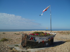
I nipped into a shop to buy a few provisions before reaching the station. A train had just arrived, and I crossed the footbridge that spanned the level crossing. As I did this I saw car parking spaces at the station meaning that the first third of a mile of the walk was redundant. My opinion of South Lancing was not much better than it had been previously - the place has a run-down, slightly derelict feel. Fortunately this improved as the seafront was reached; I had to divert to the east slightly to reach the point where my previous walk had left the seafront.
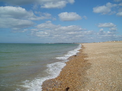
A promenade started taking me eastwards starting off besides an octagonal bandstand, and from here the walk improved. A large shingle beach lay off to my right, whilst to my left was an area of parkland. Static caravans soon encroached, and large stone groynes were visible stretched into the water on the left. In the distance to the right were the hills of the South Downs, on which stood prominently the Gothic chapel of Lancing College.
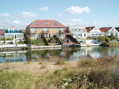
Eventually I reached the Widewater Lagoon. This is a large expanse of brackish water that is separated from the sea by the shingle beach. At one time it formed the course of the River Adur, until the original, western, mouth was blocked by the beach. Many houses back onto the water, which has many boats of varying shapes and sizes on it. An information board told me that a project had recently been completed to allow flows of water to maintain the salinity of the water. Although not in places the most attractive view, it certainly made for some interesting views.
The lagoon eventually ended as I approached Shoreham-by-Sea. At this point I decided to drop down onto the beach to walk as far as the wooden West Breakwater, which was visible in the distance. The breakwater marks the modern mouth of the River Adur. Behind, I was surprised that I could just make out Worthing Pier. At first the going was easy, with a narrow band of sand in place at the surf line. Unfortunately this ended all too soon, leaving me a thigh-straining walk along the shingle. A few people were scattered about the beach, including a family bravely swimming in the sea.
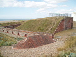
The breakwater seemed to hover in the distance, never getting much larger as I struggled along the shingle. Eventually I reached it and headed up to reach the car park by Shoreham Fort. This was completed in 1857, and has recently been renovated to allow more public access. Strangely was used as a base for early filmmaking, with several silent films being made at the studio, despite the absence of electricity!
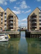
The River Adur would prove to be a uninteresting diversion. Although I only headed half a kilometre inland, the walk was extended due to the unusual configuration - I had to walk west to cross the River Adur, followed by a walk east past the docks. The initial stretch passed a relatively new estate of flats, some of which had their own little boat harbour. It looked like a pleasant place to live; it was a shame that the views from the rearmost flats would have been over the tidal river and the various metal and aggregate firms on the northern side. White-painted bollards on the walkway showed that this side of the river had once also been used for mooring boats.
An interesting footbridge-cum-drawbridge saved me from a long stroll up to the A259 bridge. This was a fairly rickety concrete construction with a central section that rolled inland to allow ships to pass, something that I reckoned had not been done for some time. Many of the boats moored downstream had tall masts, whilst those upstream were all much smaller. The bridge seemed to be a popular short-cut, with many people crossing it along with me.
Unfortunately this dumped me out onto the main road that runs along the northern side of the harbour. To my right were the aggregate and scrap-metal plants I had seen from the other side of the river; to my left were various industrial units and other firms. I resisted the temptation to nip to the burger van that was sited outside a B&Q, and instead strolled on. Large, alien-looking machines were shifting scrap metal about in a yard beside the road, their movements performed with an almost organic gracefulness.
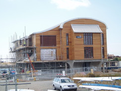
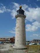
The RNLI lifeboat station that sits opposite the mouth of the river was being rebuilt. The new structure was a fairly spectacular concrete and wood ensemble that was surprisingly attractive, despite the scaffolding that still clad some of it. Nearby was Shoreham lighthouse, built in 1846 to guide ships into the harbour. It is a lighthouse in miniature, short, but with a width in proportion to its height. It looks as though the lifeboat station will well complement the lighthouse.
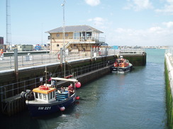
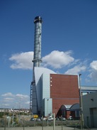
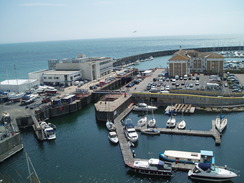
Shortly after this I reached the point where I could cross the sets of lock gates that controlled access into the eastern harbour. A few fishing boats were moored up, and the harbour itself did not seem particularly busy. The tall chimney of the Shoreham power station dominated the view westwards past the docks. It is a clean, modern structure of brick and steel, and is about as far away from the classic, grimy power station as it is possible to get.
The dock away from the lock gates was strictly guarded by high fences on both sides. Once the seafront was reached once more, I turned right to head towards the East Breakwater, which guards the eastern river mouth. This was an unnecessary diversion, but one that allowed me to get another glimpse of the river. The beach to the left was still made from the same shingle, and I was glad that there was a good promenade. Sighting the river mouth made me realise quite how far I had walked just to cross a few metres of water - always a sad and slightly annoying fact.
I started heading east once more. The promenade was surprisingly busy, especially as the area to my left was robustly industrial, initially with the power station and then a company dealing in steel. This had large overhead cranes that used electromagnets to grasp the girders that lay below. The promenade soon ended, and I was forced to walk along a road that had a large parking area running along it. This was filled with lorries, and this industrial stretch was far from an enjoyable stroll.
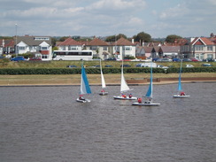
Fortunately the promenade eventually restarted, and the walk eastwards became much more pleasant. It was bustling, with many people enjoying the summer sunshine. The boating lake to the left was busy with small boats, and a speedboat was roaring about on the sea, with a bunch of schoolchildren excitedly waiting their turns. I stopped off to eat an ice cream, which immediately started melting, dropping goo all over my trousers and map case.
Large buildings on the left signalled my approach to Hove. The town has been subsumed into the larger Brighton, and it proved impossible to tell when I had left one and entered the other. A grey haze of birds a short distance out to sea marked the site of the Brighton West Pier, which I knew would be a sad sight. I last walked along this stretch of coast in December 2002, and my impressions of Brighton had been far from favourable. This time, however, I felt better about the place. It was busy, but not too much so, and there was plenty of interest to see amongst the usual tourist tit-tat. In particular there was a fishing museum that appeared highly interesting.
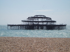
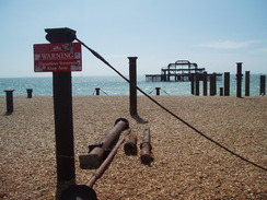
As expected, the West Pier was a sad sight. The difference was marked; eight years before the pier and its buildings had been more or less intact, with the large red West Pier' lettering easily visible. Fire and storms had taken their toll, and now there was little more than rusted, twisted metal sticking out of the water. The landside entrance building was a messy eyesore, in direct contrast to the surroundings.
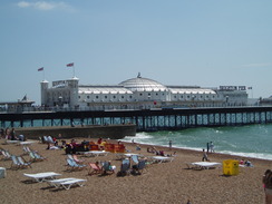
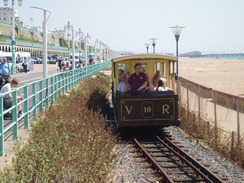
A happier sight loomed nearby: the larger Palace Pier, which is still in fruitful use. The area around it was buzzing, and although I usually find such areas rather off-putting, there was a pleasant atmosphere that made me quite like Brighton. It certainly felt different to some seaside resorts. There was a pub that I was tempted to nip into for a break, but instead I walked on, soon reaching the easternmost station of the Volks Electric Railway. This was opened in 1883, and is the oldest surviving electric railways. It had taken various forms over the years (including trains on stilts that ran through the sea!) before settling on the current line alongside the beach. The trains were running as I walked, and seemed to have been filled with passengers.
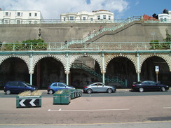
The promenade became quieter as I headed eastwards, with fewer people about (although still bustling compared to the path past the Widewater Lagoon). There were actually three promenades here; the lower one that I was walking along, the one at the top of the cliffs, and one midway down the cliffs. Supporting these were attractive blue-and-white metal arcades, although the concrete walls behind were less pleasing.
The promenade ended when I reached Black Rocks, the eastern end of the Volks Electric Railway. Ahead lay the massive Brighton Marina Village complex, which has houses, moorings and shops. Here I was faced with a choice; I knew that there was a walkway running along the bottom of the cliffs towards Rottingdean, but had no idea how far it went. Instead of risking it, I climbed up to the top of the cliffs and started following them eastwards. This meant that I got some fairly spectacular views out to sea, and also down over the marina complex.
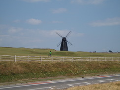
Soon I passed the imposing buildings of Roedean School. It was near here that I met Graham Harboard on the coastal walk - he was walking in the opposite direction, and it was quite a coincidence that we managed to bump into each other. Large red cranes marked the worksites for some water works that were ongoing, and that I would continually see as I walked towards Newhaven. Sadly, there were also signs for the Samaritans. A steep descent took me down past a black windmill into Rottingdean, and what followed was a series of climbs and falls as I headed east along the top of the cliffs. Eventually I decided to stop for a few minutes at a bench beside the path, but only for a couple of minutes as I transferred water between bottles.
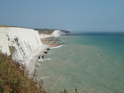
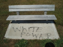
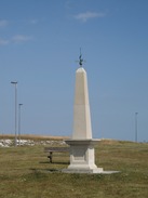
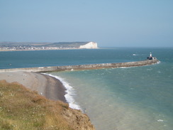
This marked what proved to be an exhilarating walk along the top of the white cliffs. One downside was a wooden bench in this seemingly genteel area; 'White power' had been spray-painted onto the concrete plinth underneath. Annoyed by this, I continued on, passing a war memorial before reaching the George V Memorial, a column that marks the point where the Greenwich Meridian leaves the mainland. From here I entered bungalow-ville, a series of bungalows sitting neatly at the top of the cliffs. These were eventually left behind as I climbed up over the coarse grassland of Peacehaven Height. Some good views were obtainable along the cliffs. In the distance I could see the breakwater that marked the entrance to Newhaven Harbour, beyond which was another set of chalk cliffs.
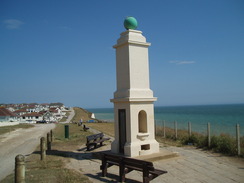
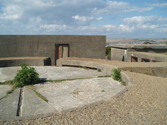
By this time I was feeling more than a little tired. The ascents seemed slightly steeper, and the descents made my knees ache a little more. It was a relief when I reached the concrete plinths that used to house World War 2 naval guns at the top of the heights. Built on top of these is a Coastwatch station. Warning signs alerted people to recent cliff falls, and I climbed up to the very summit before descending down to reach Fort Newhaven. This is now a museum, and the car park was guarded by replica shells - a good touch. Instead of taking the path that headed steeply down to the road at the bottom of the cliffs I took the looping access road, a longer walk. This eventually dumped me out at the road, and I started the long walk alongside the River Ouse.
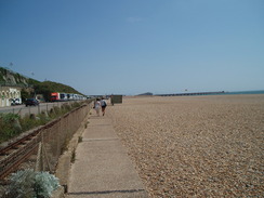
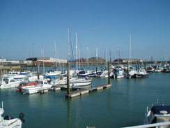
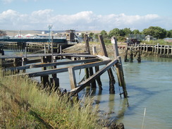
I decided to keep as near to the water as possible, which led me past a marina and then some shops; one was a newsagents where I managed to buy a bottle of water that allowed me to replenish my supplies. The next stretch should have been boring, but I found the views over the river to be pleasant in a post-industrial way. Some old, ramshackle staithes seemed to bowing down to the river. Fortunately there was not too far to go to reach Newhaven Town station, and I reached it a few minutes before a train was due.
It had been my intention to spend the night at a campsite and do the next stretch past the Seven Sisters and Eastbourne tomorrow; unfortunately I had not been able to get through to any of the campsites on the phone. The day had been exceptionally pleasant, and I decided to cut the trip short and head back home. It meant another long drive (after the train journey, which involved a change of trains), but the short trip had been well worthwhile. Although hardly a classic walk (especially in the Shoreham area), it was a highly enjoyable stroll.
 |
 |
|
Directions
This walk starts off at South Lancing station; I started it at a car park further north, but the station is a good central place to officially start it. Leave the station and head towards the level crossing at its eastern end, then turn right to start following South Street southwards. This soon curves to the left to end at the A2025 South Street. Turn right and follow the A2025 southwards for a third of a mile until it ends at a T-junction with the A259 road. Turn right to head westwards along this road for a couple of hundred yards until a promenade is reached on the left.
Turn left to join the promenade, immediately passing a pleasant-looking octagonal bandstand. Follow the promenade eastwards for a mile and a half, passing the Widewater Lagoon on the way. When the promenade ends by some car parks you have a choice; you can either join the shingle beach and follow it eastwards for a little over a mile towards the West Breakwater. When the breakwater is reached, climb up to join a rough track that heads northwards, passing Shoreham Fort. Enter the car park, and then leave westwards via Forthaven road. This road ends after a couple of hundred yards at a T-junction with Old Fort Road. Turn right and skip the directions in the next paragraph.
Alternatively, join West Beach Road and follow this eastwards. This ends at a junction with the King's Walk. Follow this road eastwards as it heads alongside the beach; when it curves to the left continue straight on along Beach Road. Some houses start on the right, and the road becomes Old Fort Road, passing a couple of roundabouts until the road curves to the left near Shoreham Fort.
Old Fort Road becomes Harbour Way as it heads northwards. This curves to the left with a car park on the right; here join a short promenade and follow it westwards. When it ends, join a sandy beach and follow it westwards towards some flats. Climb up and join another promenade called Osprey Walk; turn right and follow this as it heads to the west, with Shoreham Harbour on the right and flats on the left. There is a little diversion to be made around a little marina. Shortly after this the promenade turns to the left and ends at Riverside Road.
Here turn right and follow Riverside Road westwards for a few hundred yards. When a car park is reached on the right, turn right down Lower Beach Road. This returns to the riverside and then curves to the left to reach the footbridge over the River Adur. Cross the footbridge to reach the A259 road in Shoreham by Sea.
Turn right and start following the A259 eastwards for 1.5 miles, passing Shoreham Lighthouse on the way. Initially there is no pavement, but one starts just after a yacht club. When a small road is reached on the right at TQ241049 (immediately past a two-tone blue building called Nautilus House), turn right down this road towards the docks. Turn right by the Adur dry dock to join a footpath that runs between fences, following National Cycle Network 2 signs. Cross two sets of dock gates, and then continue on southwards to reach the seafront promenade in Southwick. If you want you can turn right and walk a third of a mile westwards to the East Breakwater, then return to this point.
Head eastwards along the promenade until it ends just before Shoreham power station. Follow this road eastwards for a little over a mile. It eventually starts to curve around the eastern end of Shoreham Harbour; at the very end of the harbour turn right to head back to the seafront. From here follow a wide promenade eastwards for four miles through Hove and Brighton until Black Rocks and the breakwater for the Brighton Marina Village is reached. Her you have a choice; you can try and make your way through the marina towards the sea wall, which I believe can be followed as far as Rottingdean.
However, I turned to the left and started to climb uphill along a road from the car park. When an underpass is reached, turn right to head up a path that leads to a road at the top of the cliffs. Cross a sliproad and turn right to start following the cycle path that runs along the top of the cliffs alongside the A259. The rest of the walk to Newhaven Fort follows the top of the cliffs; it dives down into valleys and ascends onto the heights, but it is easy to follow at all points. The only exceptions were as follows. Firstly, the main road has to be followed for a couple of hundred yards through Rottingdean; the clifftops can be regained immediately to the east. The other was a diversion that had to be made near the Badger's Rest pub in Peacehaven to reach the main road; this may have been temporary due to the water works.
The going becomes wilder as the path leaves Peacehaven behind and climbs up onto Peacehaven Heights and then Harbour Heights. Eventually the remains of Second World War gun plinths are reached on Castle Hill. Here start to head inland slightly to join a track that leads down to the car park for Fort Newhaven. Either follow the access road that leads downhill from the car park to reach Fort Road, or walk through the car park to reach the entrance, from where a path descends down to reach Fort Road.
Turn left to start heading north along Fort Road with the River Ouse to the right. Turn right along Riverside, which passes Newhaven Marina to reach the lifeboat station. From here continue on northwards along a path beside the river bank. This joins Riverside North road, which itself ends at South Way. Turn right along South Way to head northwards for a short distance until a bridge over the River Ouse is reached. Turn right to cross the bridge; on the other side take a sliproad off to the right which descends down towards Newhaven Port. Continue straight on, before turning to the right to reach Newhaven Town railway station, where this walk ends.
 |
 |
|
Distances
| From | To | Distance (m) | Ascent (ft) | Descent (ft) |
|---|---|---|---|---|
| South Lancing | Shoreham Fort | 4.7 | 26 | 46 |
| Shoreham Fort | Palace Pier, Brighton | 8.7 | 144 | 144 |
| Palace Pier, Brighton | Rottingdean | 4.0 | 692 | 653 |
| Rottingdean | Newhaven Town station | 6.7 | 1453 | 1490 |
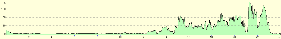
This makes a total distance of 24.1 miles, with 2315 feet of ascent and 2333 feet of descent.
For more information on profiles, ascents and descents, see this page
Transport
There are regular train services running from Newhaven Town back to Lancing; you change either at Brighton alone, or at Brighton and then Hove. The fare costs £7.40.
 |
 |
|
 |
 |
|
 |
 |
|
 |
 |
|
 |
 |
|
 |
 |
|
 |
 |
|
 |
 |
|
 |
 |
|
 |
 |
|
 |
Disclaimer
Please note that I take no responsibility for anything that may happen when following these directions. If you intend to follow this route, then please use the relevant maps and check the route out before you go out. As always when walking, use common sense and you should be fine.
If you find any information on any of these routes that is inaccurate, or you wish to add anything, then please email me.
All images on this site are © of the author. Any reproduction, retransmissions, or republication of all or part of any document found on this site is expressly prohibited, unless the author has explicitly granted its prior written consent to so reproduce, retransmit, or republish the material. All other rights reserved.
Although this site includes links providing convenient direct access to other Internet sites, I do not endorse, approve, certify or make warranties or representations as to the accuracy of the information on these sites.
And finally, enjoy your walking!
Nearby walks
| # | Title | Walk length (miles) |
|---|---|---|
| 298 | Beachy Head to Peacehaven | 16.7 |
| 299 | Peacehaven to Worthing via Brighton | 20.5 |
| 300 | Worthing to Pagham | 18.7 |
|
|

|