Walk #299: Peacehaven to Worthing via Brighton
 |
 |
|
General Data
| Date Walked | 17/12/2002 |
| County | East Sussex, West Sussex |
| Start Location | Peacehaven |
| End Location | Worthing |
| Start time | 08.28 |
| End time | 15.39 |
| Distance | 20.5 miles |
| Description | This was a fairly enjoyable walk through Brighton, Hove and Shoreham to Worthing. |
| Pack | Today I carried my 30-litre Karrimor HotRock rucksack, which was filled with my packed lunch, waterproof leggings, water bottle and a couple of spare shirts, together with the usual assortment of odds and ends. |
| Condition | I feel absolutely fine after this walk, and am only suffering from a general tiredness. I cold easily have walked further if the need had required, but a few minutes after I stopped both my legs seized up, which was quite funny. I have had yet another day with no blisters, which makes seventy-eight days walking and only one small blister, which I find amazing. |
| Weather | For the third day in a row the weather improved today. There was a thin layer of cloud, but there was occasional gap in the cloud that let the sun through. The wind was light all day, but it was fairly cool and I was glad I had my fleece on first thing in the morning. |
| OS map | Landranger number 198 (Brighton & Lewes, Haywards Heath) |
 |
 |
|
 |
 |
|
Map of the walk
Maps courtesy of Google Maps. Route for indicative purposes only, and may have been plotted after the walk. Please let me have comments on what you think of this new format. For a detailed table of timings for this walk, please see the table file.
Notes
This was a long but unchallenging walk west from Peacehaven through the coastal towns and conurbations to Worthing. I wanted to try to get a walk of more than twenty miles in today to make up for the walk of only ten miles that I did a few days ago; also it is nice to get some speed up on a nice straight section of coast - I feel like I am really making progress now. This will continue for another couple of days until I get to the Portsmouth and Southampton area, where progress will slow once more around the little inlets and estuaries in that area.
Whilst I was walking beside the road on the cliffs through Roedean towards the marina I saw a man and woman waling towards me. The man was laden with heavy pack, and so I decided to stop for a chat and was amazed to find that he was another person who was walking around the coast. His name was Graham, and he had set off from his home in Gloucester about two weeks before I set off from Edinburgh. He is attempting to raise money for a charity he set up in memory of his wife, called Carol's Smile. It was great to find another person who was doing the walk at the same time as me, and we worked out that we would meet again somewhere in the northwest. He is doing a 5,000 mile walk is staying in B&B's or supporters homes and will be camping in Scotland. He is also walking slightly less distance each day and is taking a day off each week, but then again he is carrying more weight. This discovery means that there are three of us walking the coast at the current time, which is great and a sign that the walk is becoming ever more popular. I wonder what the odds of bumping into someone else doing the walk is - the odds of us doing the same route at the same time and of stopping and talking. We have swapped details and I hope to be keeping in contact with him as his walk progresses.
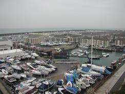
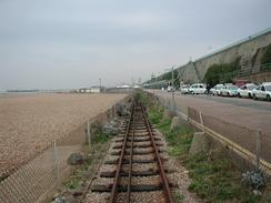
Brighton was somewhere that I had to admit looked dinghy in the winter light. From the marina you had a choice of either walking along the shingle beach or the wide road at the base of the cliffs - there was no footpath and the attractive Victorian architecture was rusting, which was a great shame The gap between the road and the beach was taken up by the Volks Electric Railway, which is the oldest electric railway in the world that is still operating. It was opened on the 4th August 1883, and has been carrying passengers from Palace Pier to Black Rock ever since. The Marina to the eastern end of the town was started in 1971 and was bustling when I passed above it although the architecture of the harbour leaves much to be desired.
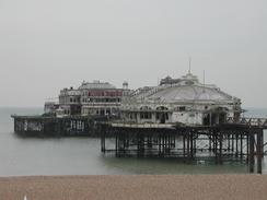
The West Pier in Brighton was very derelict, with a temporary walkway having been built across the piles to the pier head. It made for a very sad sight, and a direct comparison could be made with the Palace Pier a short distance away. The structure of the pier was literally falling down, and it looked very sad in its decay. I do not know if there are plans to either demolish it or restore it; but the latter option looks as though it would be massively expensive, as the decay has set so far in. It would be lovely to see it restored, but I suppose that it should only be done if a use can be found for it afterwards, or the decay will just set in once more.
Hove, on the other hand, was a very nice town. The Georgian architecture was lovely and the houses near the sea front were all smart and well cared for. It was also less overtly commercialised and seemed a much nicer place to me. The two towns of Brighton and Hove form one large conurbation, and I found a stark difference between he two. On the news this morning there had been an article about a toilet attendant in Hove who had won the accolade of Toilet Attendant of the year 2002. Whilst I walked along the seafront I recognised the toilets from the program and so nipped in, and they were very well looked after.
I decided to walk along the seafront past the harbour in Portslade, but I was unsure from my map whether I could cross the harbour at the lock gates. If I could not cross there then I was faced with a walk back for a couple of miles. Fortunately a public footpath crosses at the gates and therefore I could use them to get onto the northern bank.
Directions
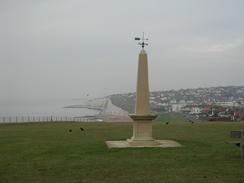
This walk starts by the King George V Memorial in Peacehaven. Follow the path that runs along the top of the cliffs as it heads westwards behind houses. After a little over a mile it reaches the Badgers Watch Pub in Telscombe, where it heads inland for a short distance to end at the A259 road.
Turn left along this road for a few hundred yards and then turn left along another footpath along the top of the cliffs. This path heads westwards along a green strip at the top of the cliffs as the A259 road gets closer until the path joins the road just to the east of Rottingdean. Follow the road through Rottingdean and then rejoin a footpath at the top of the cliffs.
This footpath continues for a couple of miles, passing by Roedean School and above the marina, as it becomes a combined cycle path and footpath. Towards the western end of the marina the path heads underneath an access road to the marina and heads down to a road at the base of the cliffs at Black Rock. Turn right and follow the road westwards alongside the electric railway until the Palace Pier is reached.
From Palace Pier continue on along the promenade, passing the disused and decrepit West Pier before entering Hove. Continue on along the seafront for several miles as it enters Portslade-by-Sea and enters the harbour area. Here you can choose to either walk along the shingle beach or the road; the latter did not have a pavement but was quiet enough.
Eventually after passing the power station a footpath sign points to the right down a path that leads to the lock gates that are the entrance to the harbour. The footpath continues over the lock gates, allowing access to the northern side of the Harbour, where it ends at the A259 road.
Turn left along the A259 and follow it westwards for a couple of miles, passing a small lighthouse and the lifeboat station until you reach a bridge across the River Adur on the left. Cross this bridge and on the other side turn left along a road. This road heads eastwards for a mile across Shoreham Beach before curving around at the mouth of the harbour and heading back westwards beside the beach, although there are houses between the beach and the road.
A couple of kilometres after the end in the road it curves away to the right and a footpath continues on beside the beach, passing by Widewater Lagoon before entering South Lancing. The A259 road then approaches, and the pavement alongside this road can be followed until it reaches Worthing Pier. The walk finished about half a mile further west of the pier, where Sam picked me up.
Distances
| From | To | Distance (m) | Ascent (ft) | Descent (ft) |
|---|---|---|---|---|
| Peacehaven | Brighton | 6.5 | 1112 | 1220 |
| Brighton | Shoreham Beach | 8.3 | 115 | 115 |
| Shoreham Beach | Worthing | 5.7 | 36 | 36 |
This makes a total distance of 20.5 miles, with 1263 feet of ascent and 1371 feet of descent.
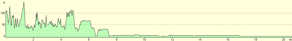
For more information on profiles, ascents and descents, see this page
Accommodation
We parked on the roadside in Worthing, a little way inland from the beach road. It was hard to find anywhere that we could park legally overnight near the seafront, so we had to move inland.
Disclaimer
Please note that I take no responsibility for anything that may happen when following these directions. If you intend to follow this route, then please use the relevant maps and check the route out before you go out. As always when walking, use common sense and you should be fine.
If you find any information on any of these routes that is inaccurate, or you wish to add anything, then please email me.
All images on this site are © of the author. Any reproduction, retransmissions, or republication of all or part of any document found on this site is expressly prohibited, unless the author has explicitly granted its prior written consent to so reproduce, retransmit, or republish the material. All other rights reserved.
Although this site includes links providing convenient direct access to other Internet sites, I do not endorse, approve, certify or make warranties or representations as to the accuracy of the information on these sites.
And finally, enjoy your walking!
This walk was mentioned in the following routes:
| My walk around the coastline of Britain |
Nearby walks
| # | Title | Walk length (miles) |
|---|---|---|
| 298 | Beachy Head to Peacehaven | 16.7 |
| 300 | Worthing to Pagham | 18.7 |
| 596 | Wivelsfield to Newhaven | 22.7 |
|
|

|