Walk #862: Poole to Wareham
 |
 |
|
General Data
| Date Walked | 19/07/2010 |
| County | Dorset |
| Start Location | Poole Quay |
| End Location | Wareham station |
| Start time | 08.36 |
| End time | 15.22 |
| Distance | 17.6 miles |
| Description | This was a surprisingly pleasant walk around the eastern and northern sides ogf Poole Harbour. |
| Pack | Today I carried my 30-litre Karrimor rucksack, filled with water, my waterproofs, a couple of books and other odds and ends. |
| Condition | I feel absolutely fine after this walk. |
| Weather | |
| OS map | Landranger number 195 (Bournemouth & Purbeck, Wimborne Minster & Ringwood) |
 |
 |
|
Map of the walk
Maps courtesy of Google Maps. Route for indicative purposes only, and may have been plotted after the walk. Please let me have comments on what you think of this new format. For a detailed table of timings for this walk, please see the table file.
 |
 |
|
Notes
I wanted to walk the stretch of coast that heads around Poole Bay, which I last did on the coastal walk at the very end of 2002. It was possible to walk from Poole to South Haven Point (at the mouth of the bay) in a day, but the route I walked in 2002 was hardly ideal, following roads in as direct a route as possible. A study of the maps showed that there were potentially better, more coastal, routes, although these were far longer. Therefore it seemed sensible to split the route up into two days, ending today"s walk at Wareham.
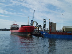
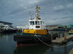
Poole is quite a large town, and there were plenty of signs to various car parks. In the end I got sucked into a multi-storey just behind the Town Quay - an expensive stay for the day, but exceptionally convenient. It proved easy to find the quay itself, which was bustling in the early-morning sunshine. It is a lovely place; a working harbour instead of the resorts that are so common on the coast. A ship was offloadfing gravel on the other side of the river, beyond which was the Sunseeker shipyard, where the vastly expensive pleasure yachts are constructed. On this side of the quay were many tour boats and the ferry that takes passengers over to Brownsea Island. It was strange to think that, despite the decline in fishing, the quay seemed as busy as ever.
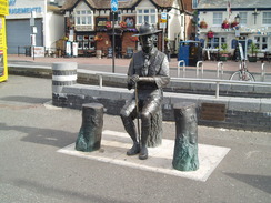
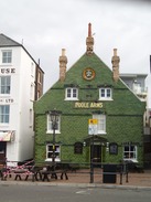
A statue of Lord Baden-Powell stood on the quayside - the first scouting camp was held on Brownsea Island in 1907, a fact the Poole seems to take some pride in. Nearby was a sculpture that was so large that it had a viewing platform at the top - I did not bother squeezing my way past the schoolchildren to climb it. The quayside is a very pleasant place, and the shops and pubs all seem to be of the place. One particular pub has a frontage of green glazed tiles that give it a memorably unique look.
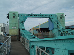
Poole is also home to the RNLI, and although I did not pass their training centre, I did see a lifeboat moored in the river. My target was the bridge over the Back Water Channel, a bascule bridge that can lift to allow ships through. Fortunately it stated down as I crossed, and I was soon in the Hamworthy area of Poole. Off to the left was the ferry port, but as Cherbourg was not on today"s route I turned right and followed the road northwards. Soon I came across a shop, where I bought a few provisions from a surly-faced woman.
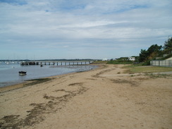
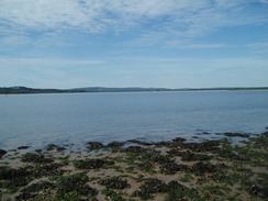
In 2002 I followed this road all the way tom Lychett Minster, but that had been a boring and uninteresting walk. Instead I followed a road off to the left, crossed a level crossing for the railway line that led to the docks, and reached an area of parkland. Although marked on the map, the beauty of this area was unexpected. The park was fronted by a short, sandy beach, and the waves were unusually tiny - the beach being in the shelter of Poole Harbour. The views to the west and south were superb, with the cliffs of Brownsea island prominent. It was hard to believe that I was so near the Poole - Bournemoth conurbation.
The park soon ended, and I followed roads westwards, diverting off down a short footpath to watch a rowboat come in. The roads had to go around a marina before rejoining the shore. Soon the houses on the left gave way to high security fences covered with ominous warning signs that protected a Royal Marines base. A landing craft was moored at a stage, and a scattering of men in military fatigues were visible. I would have loved to have a look around, but instead I plodded on.
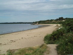
The houses ended after the base, allowing me to get access to the sandy foreshore. Behind the beach were a couple of houses that had their own arched underground garages for boats, along with a concrete slipway leading to the water. An impressive - and I expected expensive - property. I headed northwestwards, passing a car park and the Ham Common Nature Reserve. Small, sandy cliffs rose up to my right, and I found the views across the bay to be superb - I could easily have been in Scotland instead of Dorset.
The sky was blue, the sand white and I felt inexplicably happy. Some people were scattered about, digging with shovels into the mud of the foreshore. At first I thought they were digging for lugworms, but one told me it was for Ragworms. The beach became less sandy, with a large expanse of mud leading to the tideline.
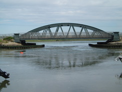
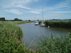
Eventually Rockley Point was reached and I turned the corner to suddenly be hit by civilisation in the form of a yacht harbour and activities center. Across the water was the Rockley Viaduct, which carries the railway line across the mouth of Lychett Bay. This is a shortcut that, if it could be walked, would save several miles of fairly uninteresting road walking to reach Wareham. Unfortunately it cannot be walked, but a couple of groups are planning for a foot and cycle bridge to be created alongside. The nearby boatyard had high racking, on which two tiers of boats could be stored.
Instead I was faced with a long walk around. Initially this headed through a large caravan park, with static caravans arrayed around immaculate patches of grass. The park seemed busy but not overwhelmed; quite pleasant if you like that sort of thing. The only downside was the smell of frying bacon that filled the air, making me want to find a place to have a burger. Near the main entrance there were facilities, including a swimming pool and curving water slide. On the other side of the park was another park; another Royal Marines base, guarded by high wire fences topped with razor wire.
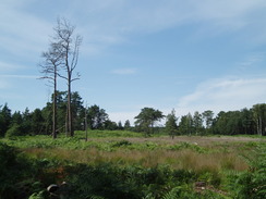
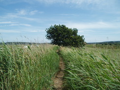
After crossing a railway line on a bridge I reached Turlin Moor. A handy information board showed a shortcut across the grass that would get me to Upton without going along the roads. It turned out to be a very pleasant diversion past the vegetation-lined creek. After a while a path led on to a dead end, where a board gave information on the wildlife.
What followed was a long road walk. I had hoped that there would be a short diversion by heading down Slough Lane to a crossing over the A35; as I started down the lane I came across a sign saying that the crossing had been closed. Fortunately a postman was cycling up the lane, and he confirmed that the footbridge over the main road was now closed, and that there was not another way across. Therefore I had to turn back and trudge my way back to a road bridge over the A35. The little noise from the A35 dissipated as I headed past the grand gates leading into a caravan park, and soon I reached Lytchett Minster church.
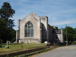
Last time I had walked this route the church had been locked, but this time it was open. I nipped in for a quick look around; it was a pleasant place, but nothing that took my breath away. I spent a few minutes in prayer and then headed off. On my previous trip I had taken some photos of a wall made out of old horseshoes outside a blacksmiths, but there was no sight of it today - a shame. Near the roundabout with the main road there was a pleasant half-thatched pub, and it seemed like as good a place as any to stop for a short break. I had my usual and went to sit outside to bask in the sun.
The next stretch of walk was by far the worst of the day - a mile along plod along the A351 southwestwards. The pavement was narrow in places due to encroaching vegetation, and traffic sped past. It was a relief when I reached the roundabout that led off to the left towards an industrial estate. Unexpectedly this turned out to be a dual carriageway, although the traffic barely seemed to warrant it. Fenced off areas lay to the left and right of the road with some warning signs hanging off, leading me to wonder what these areas were.
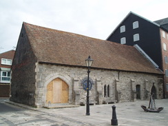
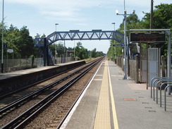
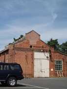
The industrial estate itself was fairly uninteresting aside from a company that seemed to be making boat parts out of GRP - a smell that I love. Holton Heath station has the impression of being in the middle of nowhere, and it was obviously built to serve whatever had preceded the industrial estate. A little research showed that it was the Royal Navy Cordite Factory, which explains the warning signs. The plant was used in both the Second and First World Wars, and part became a nature reserve in 1981. A railway line was built to Rockley Jetty, where ships could be supplied. This explains my next find: an obvious engine house, complete with ventilators on the roof.
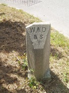
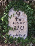
A pleasant walk through a wooded area followed, the only sign of the past being stone MOD markers on the ground. This led into Sandford, and then back onto the main road. The approach to Wareham was not particularly memorable, and I crossed the railway line by a pedestrian level crossing just before the station. This was where I was intending to end the day, but first I had a little loop to do. An underpass took me under the main road and across to the North Bridge, from where there were pleasant views across the floodplain of the River Piddle.
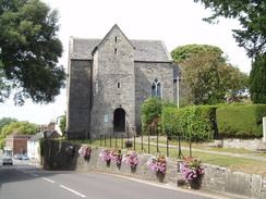
A hill led up towards the Saxon church of St Martin-on-the-Walls, passing the Saxon town walls (actually earthen banks, built by Alfred the Great). Before the church I took a road that led up onto the walls", from where there were some pleasant views over the floodplains. As soon as possible I descended down to meet a track that led eastwards along the floodplain of the River Piddle. At one point a cat chased a squirrel across the road in front of me; the cat saw me, stopped, and guiltily slunk away.
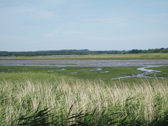
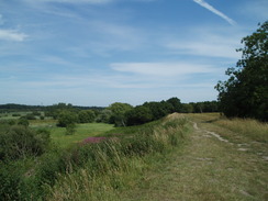
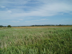
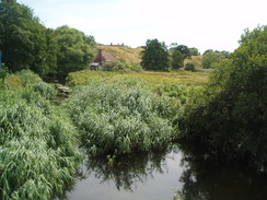
Trees enclosed the path at first, and there was not much to be seen until it emerged out onto the floodplain itself. What followed was a very pleasant walk eastwards towards Swineham Point. At the point the path joined the floodbanking, and I followed this as it twisted and turned along the northern bank of the River Frome.
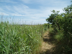
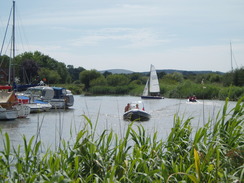
Boats started appearing on the river to my left, and the number increased as I headed towards the town. The path was fairly overgrown in places, making me glad that I had not worn shorts. Unfortunately the vegetation also reduced the views across to the river, the only good points being when the river curved around, giving me a longer view. Eventually a boardwalk started, which took me inland away from the Town Quay. Paths and roads led me to the Priory Church, from where I headed north through the town.
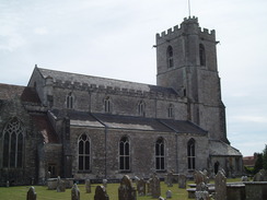
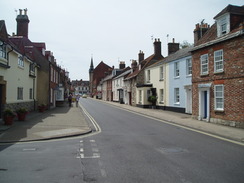
I vaguely remembered being impressed by Wareham, but I had not returned to the small town since. Therefore it was a pleasant surprise to discover exactly how nice it is - many Georgian buildings are still intact, giving it a certain period feel that, due to the bypass, is thankfully unencumbered with traffic. It was somewhere I wished to explore more, but a train was due soon so I walked fast north through the town, descending past the tiny Saxon church to reach the station. It had been a surprisingly enjoyable day"s walk.
 |
 |
|
Directions
This walk starts off at Poole Quay. Head west from the quay, following the road as it curves around to the right to reach the lift bridge over the Back Water Channel. Turn left to cross the bridge, and on the other side continue on westwards for a short distance to a roundabout. Here turn right to start following Blandford Road northwestwards for half a mile. When Ashmore Avenue is reached on the left, turn left down it and follow it as it crosses a level crossing over a railway line. Immediately after this the road curves to the right; continue straight on into a park, and head towards the foreshore.
Turn right and follow the foreshore westwards alongside the park. It soon ends when the beach becomes private by some houses start; turn right along a path, and then before the tennis courts turn left to join Branksea Avenue. Follow this road westwards, it soon starts to curve to the right after Lake Road comes in from the left. Take the next road off to the left, Lake Avenue, and follow this westwards with the Moriconium Quay to the left. When this road soon ends turn left down Lake Drive, and follow this road as it heads back towards the foreshore. It curves to the right and then passes a Royal Marines base to the left. Immediately after the base fence ends, pass a house and then turn left down a short road to access the foreshore.
At the foreshore turn right and start following the sandy beach northwestwards. It passes a pier on the left and a car park on the right; if the tide is high then you will have to divert inland here through Ham Common Nature Reserve. If not, continue on along the foreshore. Slowly it becomes more muddy and rocky as low cliffs form on the right. Continue on past Rockley Point and around to the Rockely Watersports activities centre. Join a road that passes the marina on the left; when the road curves sharply to the right head straight on alongside a fence on the left, with stored boats racked up within the compound.
The path leads into a holiday park. From here make your way through the large complex to the main entrance; there are many directions signs to help you.
Exit through the main entrance and then immediately turn to the left, to head north along a tarmac path that heads between two widely-spaced fences, with the holiday camp on the left and a Royal Marines base on the right. The path reached a pedestrian footbridge over a railway line; cross this and continue on northwards down Foreland Road, which soon ends at the grass parkland of Turlin Moor.
You could turn right to walk east along Turlin Road; a viable alternative is to head half-right across the grassland, aiming for the far left-hand edge of the treeline ahead. A path squeezes between the edge of the trees and the estuary on the left. The path continues on with trees on the left, before heading through the trees and an area of scrubland to end at Border Drive. Turn left to head westwards along the road; when it ends turn right down Shore Lane, which soon ends at a T-junction with Sandy Lane.
Turn left and follow Sandy Lane as it heads northwestwards through Upton, becoming Watery Lane. A little under a mile later the road curves sharply to the right by French"s Farm, becoming Policemans Lane to head north uphill to end at the B3067 Dorchester Lane. Turn left along the B3067 as it immediately crosses the A35 on a bridge. The road curves to the left as it descends, heading in a more southwesterly direction into Lytchett Minster. Walk through the village and continue on until the B3067 road ends at a large roundabout with the A45.
Carefully cross the roundabout and continue on southwestwards along the A351; there is a pavement on the left. After a mile a roundabout is reached, turn left down Blackhill Road, which is initially a dual carriageway. Continue on southeastwards for half of a mile until it ends at a T-junction with another road. Turn right and follow Holton Road southwestwards; when a large roundabout is reached turn left down a road that curves to the right to parallel the railway line to reach Holton Heath railway station.
At the station turn right before the footbridge is reached, heading down Station Road. When the road curves to the right, turn left down a footpath that enters some scrub woodland. The obvious path heads southwestwards for three-quarters of a mile; it then runs behind some houses and ends at Keysworth Drive. Turn right down this road and follow it until it ends at the A351 road. Turn left and follow the A351 southwestwards.
At a roundabout the pavement swaps over to the right-hand side of the road; carefully cross the road and follow it downhill to Sandford Bridge. Climb up the other side, and continue on uphill for a short distance. When Sandford Road starts on the left, carefully cross and join this new road. It heads southwestwards, soon passing under the A351 to reach a roundabout near Wareham railway station.
Turn left and cross the railway line using the pedestrian crossing. On the other side follow North Causeway southwards; just before a roundabout is reached, follow a cycle path that heads off to the right, heading under a road using an underpass. This rejoins North Causeway on the other side of the roundabout. The road crosses the River Piddle at North Bridge; head on up the hill, and before the Saxon Church is reached turn left up Mount Pleasant Road.
At the top, a grassy bank of the town walls starts on the left. Join this and start following it eastwards. The bank turns sharply to the right; after a hundred yards turn left to descend down the bank to reach a tarmac track at the base. Turn left and follow the track as it curves to the right. Continue along the track towards North Bestwall House; here a footpath leads off to the left, soon turning to the right to head eastwards towards Swineham Point.
The path curves to the right at the point before going through a clapper gate to join a track. Follow this track westwards for a short distance until there is a little inlet on the left; turn left to join a footpath that walks along the top of the flood banking. This curves around as it heads in a rough westerly direction in company with the River Frome. After a little under two miles a boardwalk is reached; this curves to head inland, and when it ends a path leads on to reach the end of East Walls. Turn right up East Walls and then take the first road to the left, Conniger Lane. This passes graveyards on the left and right before curving to pass the church.
At the church turn right to head north up Church Street. This ends at East Street; turn left to reach the crossroads in the centre of Wareham, opposite the Red Lion Hotel. Turn right to head north along North Street. This passes the Saxon church on the right, and then descends down the hill to meet the route walked earlier in the day. From here it is a simple case of walking back to the railway station, where this walk ends.
 |
 |
|
Distances
| From | To | Distance (m) | Ascent (ft) | Descent (ft) |
|---|---|---|---|---|
| Poole Quay | Lytchett Minster | 7.4 | 390 | 367 |
| Lytchett Minster | Wareham station | 5.1 | 118 | 128 |
| Wareham station | Wareham station | 5.1 | 95 | 102 |
This makes a total distance of 17.6 miles, with 603 feet of ascent and 597 feet of descent.
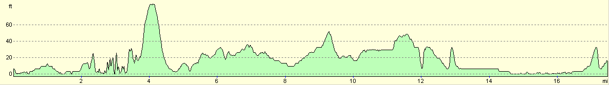
For more information on profiles, ascents and descents, see this page
Transport
There are regular train services running between Wareham and Poole. It is a short walk through the town from Poole station to the Town Quay.
 |
 |
|
 |
 |
|
 |
 |
|
 |
 |
|
 |
 |
|
 |
 |
|
 |
 |
|
 |
 |
|
 |
Disclaimer
Please note that I take no responsibility for anything that may happen when following these directions. If you intend to follow this route, then please use the relevant maps and check the route out before you go out. As always when walking, use common sense and you should be fine.
If you find any information on any of these routes that is inaccurate, or you wish to add anything, then please email me.
All images on this site are © of the author. Any reproduction, retransmissions, or republication of all or part of any document found on this site is expressly prohibited, unless the author has explicitly granted its prior written consent to so reproduce, retransmit, or republish the material. All other rights reserved.
Although this site includes links providing convenient direct access to other Internet sites, I do not endorse, approve, certify or make warranties or representations as to the accuracy of the information on these sites.
And finally, enjoy your walking!
Nearby walks
| # | Title | Walk length (miles) |
|---|---|---|
| 312 | Southbourne to Hamworthy Station | 15.3 |
| 313 | Hamworthy Station to South Haven Point | 18.0 |
| 314 | South Haven Point to Worth Matravers | 16.7 |
|
|

|