Walk #598: A circular walk from Badby via Lower Shuckburgh
 |
 |
|
General Data
| Date Walked | 27/03/2004 |
| County | Northamptonshire, Warwickshire |
| Start Location | Badby |
| End Location | Badby |
| Start time | 08.51 |
| End time | 16.02 |
| Distance | 21.4 miles |
| Description | This was a very nice walk, taking in the highest point in Northamptonshire and part of the Grand Union Canal. |
| Pack | Today I carried my 30-litre Karrimor HotRock rucksack, which was filled with my waterproof leggings, water bottle, trainers and a couple of spare shirts, together with the usual assortment of odds and ends. It weighed slightly more than usual as I also had a bit of extra kit, such as my Psion, battery charger and cables. |
| Condition | I feel absolutely fine after this walk, and I could easily have walked further after a little rest if I had needed to. After the three blisters I got from last weeks walk I got none today, and my feet are in fine fettle. |
| Weather | Today was mostly a dry day, but the sun did not deign to make much of an appearance either. There was no wind and it was also quite warm for the time of year, which meant that it was a lovely day to do a walk. There was a light shower of drizzle towards the end of the walk, but this only lasted a few minutes and did not bother me at all. |
| OS map | Landranger number 152 (Northampton & Milton Keynes) and Landranger number 151 (Stratford-upon-Avon, Warwick & Banbury) |
 |
 |
|
Map of the walk
Maps courtesy of Google Maps. Route for indicative purposes only, and may have been plotted after the walk. Please let me have comments on what you think of this new format. For a detailed table of timings for this walk, please see the table file.
Notes
The aim of today's walk was to walk to Arbury Hill, which is the highest point in Northamptonshire. An early start got me to the village of Badby shortly before nine, and I parked my car in a narrow street below the church before locking it up and heading off out of the village. Once the A361 was reached I crossed it and took a minor lane onwards, enjoying being out of the office and in fresh air after an unrewarding week at work.
As I walked along the path that skirts the side of Arbury Hill I was dismayed to see a Landrover on the hillside above me, herding sheep off the hill and cows onto it. A quad bike soon joined the Landrover, and I began to wonder if I would be able to make it to the top of the hill, which has no right of way to the top, unseen. As I walked around the southern side of the hill I lost sight of the vehicles, but the cows were plodding on above me. Eventually I decided to risk it, and I climbed up the flank of the hill, crossed the boundary, and made my way onto the flat plateau.
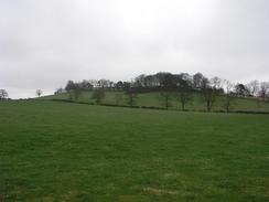
The views were not as good as I had been hoping that they would be, as there are many other low, flat hills in the immediate area. I get the feeling that some form of earthworks covers the top of the hill, and I ended up wondering if this was some form of prehistoric settlement. When I got home I found out that there was indeed an Iron Age settlement on the summit of the hill, and this explained the earthworks around the edge of the summit. I took a few photographs from the top, hoping to make a panoramic photograph when I got home, but I really did not want to hang around and so I descended down from the summit to the southwest.
I rejoined the bridleway to the west of Arbury Hill, passing the source of the River Nene on the way, and followed it past some large man-made earthworks. These puzzled me until I saw a wide, squat tubular brick chimney sticking out of the top. Looking at the map I soon realised that the earthworks were a spoil heap from the construction of the Great Central Railway's Catesby tunnel, and the brick chimney was a ventilation shaft for the tunnel. The Great Central Railway was shut in 1968 (a move which many people think was a mistake), and although there are some plans to reopen it various parts of the line from London are slowly disappearing as cuttings get filled in and viaducts demolished.
A short walk along a road took me to the pretty little village of Hellidon, and I diverted off the road to have a quick look around the church, which is on top of a little hill. This diversion meant that I had to descend back through the village to gain access to a bridleway that ran northwestwards along a broad and easy to follow track, curving twice before crossing the Northamptonshire / Warwickshire border and ending at a road. As I walked towards the end of the bridleway I was disturbed to hear gunshots very close by, and I realised that there were people shooting in a field between the track and the next hill that I had to climb.
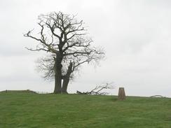
Another short stint along northwards along a road was followed by a nice climb uphill, skirting the edge of some woodland before reaching a trig point at the top of Beacon Hill. When I reached the top I was pleasantly surprised; where the views from Arbury Hill had been sparse at best, the views west and southwards from this hilltop were stunning, with seemingly the whole of Warwickshire laid out beyond Napton-on-the-Hill on the plain below. It seemed like a good place to stop for a rest, but I decided against this and after taking some photos of the views (which would have been much better on a clear day) I headed off along the hill, following the edge of Long Hill Wood, which was, as the name suggests, a long wood.
The church in the park at Shuckburgh was surrounded by trees, and despite waking around it I could not find a good location to take a photograph without the trees obscuring the view. There were signs marking the parkland to the north of the church as being private, so instead of taking the direct route along a track to the Bush Hill I had to divert off northwestwards. A footpath down a little valley took me away from the church, and after passing a beacon I descended down to the village of Lower Shuckburgh. I passed another lovely little church before reaching bridge 104 over the Grand Union Canal. I had walked along this stretch of canal a couple of times before, so it felt a little like seeing an old friend as I ambled along it northeastwards for a mile to the next bridge.
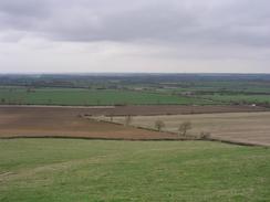
At bridge 103 I left the towpath and crossed the bridge to the eastern bank of the canal. From here a footpath led across a ploughed field, skirting the base of Bush Hill. I had decided to climb up this hill to get to the trig point at the top, but as there was no footpath I had to climb uphill across the field, climb over a hedge before eventually reaching the trig point slightly out of breath. This hillside was hardly salubrious surroundings, with farm buildings a few yards away and a big heap of manure twenty feet from the trig point. The views, however, were superb, with miles of Warwickshire to the north and west being clearly visible. On a clear day they would have been breathtaking; thanks to the slight haze they were not quite that good, but lovely nonetheless.
I descended a few yards to the south to join a footpath that led through the farmyard before reaching a road that led downhill into the village of Flecknoe. A little road walking through the village and past a curious brick building (which I thought may have been some form of two-level military blockhouse), before I diverted off along another footpath across a field. This soon skirted the edge of an old railway cutting, before rejoining the road once more. This passed the abutments of a bridge that used to carry the Great Central railway line over the road, before reaching the Wolfhampcote Church, seemingly in the middle of nowhere. This fourteenth-century church served a now-abandoned mediaeval village is no longer in use, but is maintained by the Churches Conservation Trust. I could not enter it but I walked around and took a few photographs.
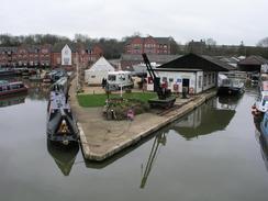
A few yards away from the church was an embankment of an old railway line, and I climbed up onto this to see if I could find a better way eastwards. Unfortunately it was too overgrown, so I headed back to the church and rejoined the road. This soon ended at the A45(T) road, and I crossed this and descended to the towpath of the Grand Union Canal to the west of Braunston. The canal dominates this village, and it not only has a large marina but also various boatyards and a British Waterways office. The towpath was bustling, and berths on the main canal were all marked with wooden plaques marked with the name of the boats that normally moored in that spot.
I was quite keen to leave the hustle and bustle, so I walked eastwards, climbing up the Braunston flight of locks, to reach the western portal of Braunston tunnel. This tunnel is 2,048 yards (1,867 metres) long, and it has been restored and relined in recent years. I could see the light of a canal boat heading towards me through the tunnel, so I leant out across the water to take a picture of it coming through the tunnel - a potentially dangerous manoeuvre! The towpath does not go through the tunnel but climbs up over the hillside along a track, passing a couple of brick ventilation shafts on the way.
Soon after the track reached the summit of the hill and started descending I reached the A361 road, and I turned right to follow this downhill to the south. Fortunately there was a pavement, and I could follow this past Drayton Reservoir, which was lined with fishermen, before taking another road that took me through Daventry. I did not find much of interest on my route through Daventry, and I was quite glad when I got out of the town and crossed a bridge over the A45(T) road before heading uphill. The map showed a windmill on the top of the hill, and so I was disappointed to find that although the base was still there, it was lacking sails and therefore looked strangely sad. The road soon led me to the church at Newnham, which is quite beautiful and quite unusual in the fact that the base of the tower is supported by four pillars, allowing you to walk right underneath it.
Newnham itself was quite nice, and I enjoyed the walk through the village, passing many attractive houses on the way as I followed the B4037 road. Almost immediately after leaving the village I turned to the left to follow the Nene Way as it headed westwards along the northern bank of the River Nene, which this near its source was little more than a stream, a far cry from its northern outfall near King's Lynn which I know well. This path then diverted slightly southwestwards to enter Badby once more, and a quick walk along a road and my car, which I was quite relieved to reach.
Directions
This walk starts off at the junction of Main Street, Church Lane and Bunkers Hill in the village of Badby. Head westwards along Bunkers Hill uphill until the A361 until the A361 road is reached. Cross the A361 and continue on along the lane that heads westwards on the other side. Just under a kilometre from the A361 a bridleway leads off to the left; join this bridleway and follow it as it heads southwestwards with Arbury Hill off to the right. The bridleway follows a broad, grassy track as it skirts the southern side of the hill and continues westwards; if you wish to visit the summit then head north uphill for a few hundred yards from the southwestern corner of the hill to reach the flat plateau. The bridleway itself continue on westwards towards some large grassed-over mounds. These mounds are spoil heaps from the construction of Catesby tunnel; pass through a gap between the heaps and then turn sharp right and left to head westwards along a track, past a farm building and to a road.
Once at the road turn left and follow it southwestwards for a few yards before it curves to the right to head westwards into the village of Hellidon. At a junction turn half-right along Main Street until it reaches a junction; at this junction I climbed up some steps and headed straight on through the churchyard past the church. The path through the churchyard ends at Little Lane; follow this westwards for a few yards before turning right down a lane that heads northwards for a couple of hundred yards along a twisting lane. When the junction with Stockwell and Berry Lanes are reached continue straight on to the north for a few yards out of the village, before turning to the left to take a bridleway that heads westwards. Initially this track is broad and easy to follow; after about a kilometre it curves to the right to head northwestwards for a mile towards the Warwickshire border, before turning to the left one more to head westwards for a kilometre before ending at a road near In Meadow Gate.
Turn right and follow this road as it heads northwards for a few hundred yards; at a junction continue straight on until it passes a farm on the right. Immediately after this farm turn right and follow a path that heads eastwards up towards the trig point at the top of Beacon Hill. Once at the trig point turn left and follow the path as it skirts the edge of Long Hill Wood northeastwards to Shuckburgh Park. Just before the church is reached (half-hidden behind trees) turn left and continue following the edge of the woodland northwestwards. Once the trees end continue straight on, passing a beacon, before descending downhill to meet the A425 road in Lower Shuckburgh. Turn left along the A425 for a few yards before turning to the right along a lane that heads past the war memorial and church to reach a bridge over the Grand Union Canal. Cross the bridge and once on the northern side of the towpath turn right and walk for about a kilometre to reach Bridge 103 on the canal.
At Bridge 103 turn left and climb over a fence to reach the bridge, and then cross the bridge to gain access to a bridleway on the other side. Follow this bridleway northeastwards for a couple of hundred yards before turning to the right and heading uphill eastwards towards the summit of Bush Hill. At the top of a field climb over a hedge and then turn left to skirt the edge of a field; this hedge then turns right and climbs steeply uphill to the trig point at the top of Bush Hill. Once having soaked in the expansive views from the trig point turn right and climb over a fence and head southwards for a few yards until a track is reached. Turn right and follow this track down a slight hill, before turning to the left to join another footpath that heads eastwards for a short distance into a farmyard. Once in the farmyard follow the track downhill; it soon becomes a road and descends downhill into the village of Flecknoe.
Follow the road as it heads through Flecknoe and then turn to the left to follow a road northwards out of the village. Near Nethercote take a footpath that heads off to the left and curves northeastwards across a couple of fields before rejoining the road next to an abandoned railway cutting. Once back on the road follow it as it heads northeastwards, crossing an old bridge over the railway cutting and past the abutments of a removed bridge that carried the Great Central railway over the road. Near a farm the road curves to the right and heads eastwards past Wolfhampcote church, which is seemingly in the middle of nowhere. A clear track continues on past the church, curving to head northeastwards and reaching the A45(T) to the southwest of Braunston. Cross the road, and once on the other side descend down to the Grand Union canal towpath. Turn right and walk eastwards along the towpath until a beautiful iron bridge is reached; cross this bridge and continue on eastwards along the towpath towards Braunston bottom lock.
Head along the towpath past several more locks until the western portal of Braunston tunnel is reached. Follow the towpath as it climbs up and follows a track eastwards uphill, passing a couple of ventilation shafts before reaching the A361 Ashby Road. Turn right and follow the A361 as it heads downhill to the south. Once a roundabout is reached turn right along the A361 Drayton Way for a few yards before turning down the first road to the left, Ashby Road. This heads southwards into the centre of Daventry; it crosses over an bridge over an old railway line before reaching a large roundabout. Use the underpass to go under the roundabout and continue straight on along the B4038 road. After a few hundred yards this curves sharply to the right, and almost immediately after it does this turn right to follow the B4038 London Road southwards. Shortly after a left-hand bend in the B4038 turn right to follow a road that heads southwards, crossing over the A45 Stefen Way before climbing up to the top of Newnham Hill.
The road descends downhill once more to a crossroads; at the crossroads turn left and follow another road eastwards for a few hundred yards until it ends at a T-junction with the B4037 road. Turn right and follow the B4037 as it enters the village of Newnham, passing the church before heading out of the village. Immediately after it leaves the village turn to the left and follow a footpath that skirts the northern bank of the River Nene, here little more than a stream. The path is actually the very first (or last) stretch of the Nene Way, and heads westwards until it nears Badby, where it turned to the left to meet Main Street in the village. Turn left and head southwards along Main Street to the junction of Bunkers Hill and Church Hill lanes, where this walk ends.
Distances
| From | To | Distance (m) | Ascent (ft) | Descent (ft) |
|---|---|---|---|---|
| Badby | Hellidon | 3.5 | 442 | 312 |
| Hellidon | Lower Shuckburgh | 5.3 | 371 | 600 |
| Lower Shuckburgh | Braunston | 4.3 | 289 | 302 |
| Braunston | Daventry | 4.1 | 348 | 223 |
| Daventry | Badby | 4.2 | 404 | 417 |
This makes a total distance of 21.4 miles, with 1855 feet of ascent and 1854 feet of descent.
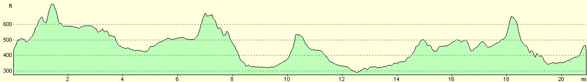
For more information on profiles, ascents and descents, see this page
Disclaimer
Please note that I take no responsibility for anything that may happen when following these directions. If you intend to follow this route, then please use the relevant maps and check the route out before you go out. As always when walking, use common sense and you should be fine.
If you find any information on any of these routes that is inaccurate, or you wish to add anything, then please email me.
All images on this site are © of the author. Any reproduction, retransmissions, or republication of all or part of any document found on this site is expressly prohibited, unless the author has explicitly granted its prior written consent to so reproduce, retransmit, or republish the material. All other rights reserved.
Although this site includes links providing convenient direct access to other Internet sites, I do not endorse, approve, certify or make warranties or representations as to the accuracy of the information on these sites.
And finally, enjoy your walking!
Nearby walks
| # | Title | Walk length (miles) |
|---|---|---|
| 157 | Wolverton to Bugbrooke | 16.6 |
| 158 | Bugbrooke to Braunston | 15.1 |
| 162 | Braunston to Leamington Spa | 16.6 |
|
|

|