Walk #406: Caernarfon to Barras
 |
 |
|
General Data
| Date Walked | 06/04/2003 |
| County | Anglesey, Gwynedd |
| Start Location | Caernarfon |
| End Location | Barras |
| Start time | 09.49 |
| End time | 16.30 |
| Distance | 17.1 miles |
| Description | This was quite a nice little walk up and down each side of the Menai Straits. |
| Pack | Today I carried my 30-litre Karrimor HotRock rucksack, which was filled with my packed lunch, waterproof leggings, water bottle and a couple of spare shirts, together with the usual assortment of odds and ends. |
| Condition | I feel absolutely fine after this walk, aside from a little fatigue that is probably to be expected after yesterday's walk. |
| Weather | Today started sunny with little cloud, but as the day went on high, thin clouds started to gather until this evening, when there was little sunshine to be seen. The wind was quite light, and there was no sign of any rain. |
| OS map | Landranger number 115 (Snowdon & surrounding area) or Landranger number 116 (Denbigh & Colwyn Bay) |
 |
 |
|
 |
Map of the walk
Maps courtesy of Google Maps. Route for indicative purposes only, and may have been plotted after the walk. Please let me have comments on what you think of this new format. For a detailed table of timings for this walk, please see the table file.
Notes
The first part of the walk led northeastwards from Carnarfon, leading from the castle using the old Bangor to Caernarfon railway line, which shut in 1972 and is now part of National Cycle Network route 4. Before I set off I chatted to a gentleman at the railway station, and we walked together for the first mile and chatted together as we walked.
Sam parked Mervan in Llanfair and walked over the Telford Bridge to meet me, and we met in the village on the other side. Fortunately her knee is much better than it was, but she wore her sandals for this walk and has ended with a couple of nasty blisters that she has put Compeeds over. We chatted as we walked back to Llanfair, and as a result my average speed that had been satisfyingly near three miles an hour reduced, but her company more than made up for it. When we reached Llanfair I took a few photographs of local signs - one on a Volvo garage, and one on the refurbished railway station. We stopped at a pub opposite the station, and we sat outside the pub whilst I drunk a pint of a satisfyingly heavy bitter and enjoyed a relaxing lunchtime. I was feeling fine at this time, and with hindsight it may have been better for me to have stopped there - despite the fact that it would have been a very short walk - rather than walk on and get more fatigued.
Ever since I was a child I have wanted to see the village of Llanfair, if only because of it's full name - Llanfairpwllgwyngyllgogerychwyyrndrobwllllantysiliogogogoch - which is the longest place name in Britain and the second longest in the world (the first is a place name in New Zealand). In English the name means 'St Mary's Church in the hollow of the white hazel near a rapid whirlpool and the church of St Tysilio near the red cave', which has to be one of the most descriptive and beautiful place names in Britain. When I was a child I could imagine what the village looked like from the name, a sylvan, beautiful glade with two churches in front of some blue lakes. Of course, I was totally and utterly wrong, and the village is quite large and bustling.
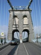
There are two bridges over the Menai Straits - the Telford suspension bridge which we crossed, and the Britannia Bridge. The latter is a combined road - rail bridge, and is named after the Britannia rock over which it passes, and was built in the early seventies on the base of the original bridge. This was a fantastic tubular design that carried a railway line, and it was destroyed in 1970 when some children accidentally set fire to it. The replacement is nowhere near as interesting as the original structure, and so I must say that I prefer the Telford Bridge, which has a series of chains instead of more modern cables acting as the suspension elements. It is a lovely little bridge, and whilst it is tiny by modern standards it was an impressive structure for 1826 when it was built, and indeed it was the longest single-span structure in the world.
Planning of the walk takes a great deal of mental effort - studying the map to see where I am going to be walking the next day can take much time. For this reason I quite like places where I can follow official coastal paths, and I am glad that one of these is slowly being created around Anglesey. Annoyingly a guidebook is due out soon, but in the absence of this Sam bought me a series of route cards that cover the route. This is still incomplete as there are not paths on certain sections - such as that between Llanfair and Llanedwen Church - but these cards will still give me a basis on which I can plan my route around the island.
I found the last section of walk from Llanedwen Church to be surprisingly hard. Some of the path goes below the high tide mark, and goes over some very rough stones - much larger than shingle, and in my trainers I found them very hard on my feet. I think that I must be suffering from the excesses of yesterdays walk - there was nothing in any way strenuous about his walk, but I am totally knackered at the end of it. I had promised myself an easy day today to help myself recover, and whilst I expected it to be easy unfortunately it did not end up being easy enough.
My parents are staying at a campsite on Anglesey, and as we were not far away we decided to stay at the same site. This was a massively good decision, as it was one of the best sites that we have stayed in on the trip so far. Mum and dad had a barbecue going, and we had a nice chat as we ate some burgers. I am absolutely shattered after this walk, and so I zombied out for a while whilst I watched the start of the Brazilian Grand Prix. Before I went back to Mervan Sam came in to give me some massively important news - the campsite has a bath! I find that baths are the most relaxing thing in the world, and I can easily spend three hours reading in a bath - at times I think that they are the only place that I can really relax. The only bath that I have had on he trip so far was on Christmas Day, so I was more than willing to pay the one pound surcharge for the bath. When I walked into the separate room everything was nearly ideal - the room was exceptionally clean and tidy, and I felt like I was in someone's bathroom rather than at a campsite. The only minor niggle was the size of the bath, which was too small for my lanky frame. This was a very minor niggle however, and I really cannot justifiably complain about, particularly as I spent over an hour in the bath! I even do not mind the fact that I missed the end of a very exciting grand prix - I left after Barichello went out, and the bath took absolute priority.
Directions
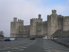
This walk starts off at the Caernarfon Station of the Welsh Highland Railway. Turn right out of the station and follow the riverside towards the castle. When the river meets the Menai Straits turn right to walk northeastwards alongside the curtain wall of the castle until the marina is reached. Walk around the inland side of the marina until a car park is reached; at this car park a cycle path heads off northeastwards, following the National Cycle Network path along the trackbed of the old Bangor to Caernarfon railway line.
The cycle path eventually joins the A487 road immediately before a roundabout is reached near the Plas Menai National Outward Pursuit Centre. At the roundabout take the second road off to the left, which is a quiet road alongside the A487. About half a mile along this road the cycle path diverts off to the left along the old railway trackbed once more until it reaches the village of Felinheli.
In Felinheli I followed the cycle path along local roads as it headed down towards the harbour and through the village, before it rose once more to meet the same local road (or you could just keep on the road through the village without dropping down to the riverfront).
As this road exits the village it becomes the B4547 road for a short distance until it ends at a roundabout with the A487. Turn left at the roundabout and walk uphill along the A487 before taking the first road off to the right. This road heads over the A55 dual carriageway and under some power lines. Just before a hospital is reached on the right turn left down another road that leads out to the A487 once more. Head downhill along the A487 and at a pub turn left to reach the Menai suspension bridge.
Cross the Menai Suspension Bridge over onto Anglesey. On the other side of the bridge continue straight on at a roundabout to continue along the A5 road. At the next roundabout follow the A5 around to the left and follow it as it heads above the northern bank of the Menai Straits. Continue on along the A5 as it passes under the A55 and continues on into Llanfair.
If you wish to visit the centre of the village then continue along the A5; otherwise the route heads off to the left at the tollhouse along the A4080. This road was quite busy and was a quite boring walk, so hopefully a new footpath will be created along this section. Follow the road southeastwards for a couple of miles, passing Plas Newydd on the left.
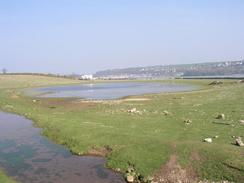
At a cross roads turn left down a minor road that heads southeastwards, passing Llanedwen Church until a track is reached on the right. Turn right along this track and follow it as it curves around to the right. From here the route follows the Anglesey Coastal Path as it heads southwestwards back to the coast.
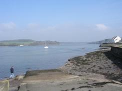
At the coast follow the high water line for a short distance until a track starts to head inland towards Llanidan House. At the house take a track off to the left for about a hundred yards before taking another footpath that heads off to the left across some fields, heading southwestwards for a couple of kilometres until it meets a road in Barras. Follow this road as it goes beside the sea until it reaches the sea zoo, where this walk ends.
Distances
| From | To | Distance (m) | Ascent (ft) | Descent (ft) |
|---|---|---|---|---|
| Caernarfon | Menai Bridge | 8.1 | 577 | 482 |
| Menai Bridge | Llanfair | 2.5 | 240 | 253 |
| Llanfair | Barras | 6.5 | 249 | 354 |
This makes a total distance of 17.1 miles, with 1066 feet of ascent and 1089 feet of descent.
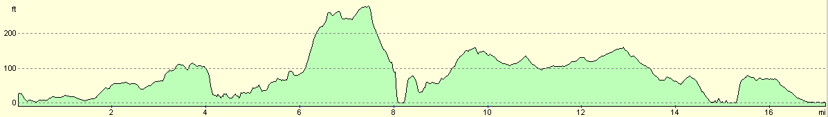
For more information on profiles, ascents and descents, see this page
Accommodation
We stayed at the excellent Home Farm Caravan Park, Marianglas, Isle of Anglesey, Gwynedd LL73 8PH, telephone (01248) 410614 or email enq@homefarm-anglesey.co.uk. They have a website at www.homefarm-anglesey.co.uk. This site was absolutely superb, and cost us ten pounds for the night. Best of all they had a bath, which for me is a totally luxurious item for a site to have.
Disclaimer
Please note that I take no responsibility for anything that may happen when following these directions. If you intend to follow this route, then please use the relevant maps and check the route out before you go out. As always when walking, use common sense and you should be fine.
If you find any information on any of these routes that is inaccurate, or you wish to add anything, then please email me.
All images on this site are © of the author. Any reproduction, retransmissions, or republication of all or part of any document found on this site is expressly prohibited, unless the author has explicitly granted its prior written consent to so reproduce, retransmit, or republish the material. All other rights reserved.
Although this site includes links providing convenient direct access to other Internet sites, I do not endorse, approve, certify or make warranties or representations as to the accuracy of the information on these sites.
And finally, enjoy your walking!
This walk was mentioned in the following routes:
| My walk around the coastline of Britain |
Nearby walks
| # | Title | Walk length (miles) |
|---|---|---|
| 404 | Clynnog Fawr to Snowdon Ranger | 22.8 |
| 405 | Snowdon Ranger to Caernarfon via Snowdon | 16.2 |
| 407 | Barras to Aberffraw | 18.3 |
|
|

|