Walk #422: Southport to Preston
 |
 |
|
General Data
| Date Walked | 23/04/2003 |
| County | Merseyside, Lancashire |
| Start Location | Southport |
| End Location | Preston |
| Start time | 09.14 |
| End time | 18.07 |
| Distance | 24.7 miles |
| Description | This was a very long walk along the south bank of the River Ribble. It was mostly along footpaths on flood banks, with only short sections of road walking. |
| Pack | Today I carried my 30-litre Karrimor HotRock rucksack, which was filled with my packed lunch, waterproof leggings, water bottle and a couple of spare shirts, together with the usual assortment of odds and ends. |
| Condition | I am quite tired after this walk, which is probably to be expected after such a long (for me) walk. The biggest problem that I had was rubbing on my Achilles of my right foot from the ankle brace, which was quite painful after a few miles until I repositioned it slightly. My right ankle was fine, and I had no other problems. |
| Weather | Today was another warm day, with some sunshine and cloud and a light cooling wind. Fortunately there was no sight of any rain, and it was an ideal day for walking. |
| OS map | Landranger number 102 (Preston & Blackpool, Lytham St Anne's) |
 |
 |
|
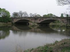 |
Map of the walk
Maps courtesy of Google Maps. Route for indicative purposes only, and may have been plotted after the walk. Please let me have comments on what you think of this new format. For a detailed table of timings for this walk, please see the table file.
Notes
On the way from the campsite to the car park at the starts of the walk we decided to drive the long way around, and drive through Southport. The town looks lovely, and I enjoyed looking at he architecture as we passed through. One of the problems with walking around the coast is that you often miss things that are only a sort distance inland, and you do not necessarily see the best parts of a town. This could be one of the reasons why I found Liverpool to be so disappointing the other day, as I saw a lot of the docks and not much of the city centre itself.
I had a hankering to do a long walk, and today seemed like an ideal opportunity to get a long walk in. As a result of this I have probably done the longest day's walk of the walk so far, and I am pleased that I managed it so well. Getting to Preston means that I am in the right place to meet a reporter from BBC Radio Lancashire for an interview first thing tomorrow morning, and this was an added impetus for me to complete the distance.
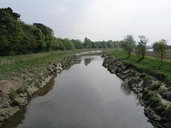
The diversion down the River Douglas was quite annoying, as it was a long diversion with very little purpose. A couple of hundred yards south of the old railway embankment (the bridge over the river has unfortunately long been removed) I found a rusty pipe bridge spanning the river. There was no ladder up to the top, but the supports looked as though they would be fairly easy to climb. After having looked at its condition, however, I decided against attempting to cross the bridge as it was very rusty and I was unsure of the condition of the walkway over the top of the bridge. I therefore continue walk along the riverbank, before diverting inland to visit Tarleton. I was in need of a rest by this stage, so I nipped into the Lord Lilford pub. I chatted to the locals for some time, and discovered that many of them use the pipe bridge across the river as a shortcut to get to Much Hoole on the eastern bank. Taking this bridge saves the three or four mile walk down the river and up the other side, but I was not devastated that I did not do this, as it allowed me to have a rest in a pub and to visit a shop.
We were watching TV in Mervan at about nine tonight when we heard a big bang on the outside of Mervan. We opened the blinds and there are three girls running away giggling. We went outside and could see no damage, but we kept the blinds half-open when we went back inside. Ten minutes later they cam back, and there was another bang as they threw something at Mervan. Sam was ready and left the van shouting at them. There were a couple of uninvolved girls outside, and I started chatting to them. They said that they liked Sam's Australian accent, and that they did not know that Australians swore!
Tomorrow I have to meet the interviewer at Preston Station at eight, and after that I am planning to walk along the north coast of the River Ribble to Lytham St Anne's, and maybe on further from there. Unfortunately this involves a long road walk along a dual carriageway to reach the start of the Lancashire Coastal Way in Freckleton, which I shall follow for the next few days.
Directions
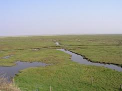
This walk starts at a car park on the Coastal Road about two miles north of Southport. Join the road and follow it as it curves around past Crossens Marsh until a sewage works is reached on the right. Here a footpath leads off to the left and follows a flood bank down to a bridge over a little creek at Fiddler's Ferry, with a big Environment Agency building beside it. Cross the bridge and then turn left down a footpath that runs along another flood bank.
This flood bank slowly curves to the right to head northeastwards, passing Old Hollow Farm before reaching Marsh Farm. here the footpath divers to the right to head down to the main road, but I took a short cut by continuing straight on along the flood bank until it curved sharply to the left. At this point I dropped down off the bank and headed straight on over a culvert to join another flood bank with a footpath running along the top of it; this diversion saved me a walk of a couple of miles.
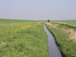
Follow this new flood bank northeastwards for a couple of miles, as it passes Ribble Bank Farm and reached the western bank of the River Douglas where the flood bank turns to the right to head southeastwards along the river. Continue on along the flood bank as it slowly curves to head southwards until a little boatyard in Hesketh Bank is reached. Continue on through the boatyard southwards and rejoin the footpath.
It passes under a pipe bridge that could potentially be used as a shortcut; if not then continue on southwards until the path ends just before a lock is reached. The path ends at a road; turn right down this road and when it meets another road turn left to follow it southwards into Tarleton. When the road ends at a T-junction turn left and follow this road as it curves around to the right and ends at a T-junction with the A59(T) road.
At the A59(T) junction turn left and follow the road eastwards to a bridge over the River Douglas. The road then turns to the left to head in a northerly direction to a roundabout near Carr House. Continue straight on for a few yards until a bridge over a stream is reached; here a footpath leads off to the left until the eastern bank of the river is reached. It then follows the river northwards, passing under the pipe bridge and past the abutment of an old railway bridge.
It continues on along a flood bank until it nears a public road, where I diverted off to the right to head eastwards under some power lines. Pass Lower Marsh House Farm, and continue on until a footpath is reached on the left. This footpath heads northwards along a track that head northwards towards Odd House Farm, before diverting off to the right through a couple of fields past the farm and rejoining the track shortly before it ends at a T-junction with another road.
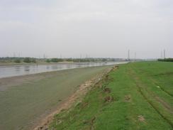
Turn left down this road; it immediately curves to the right and then left before heading westwards under some power lines. Here a footpath heads off to the left to head westwards back to a flood bank beside the River Douglas. Turn right along the bank and follow it as it joins the Ribble Way near a pub and continues northwards to meet the southern bank of the River Ribble.
Turn right and follow the flood bank eastwards for a few miles, until it passes under a road bridge and meets another bridge. At the second bridge turn left to cross the river and at a junction continue straight on down another road, which heads straight on northeastwards for half a kilometre until Preston Station is reached on the right, where this walk ends.
Distances
| From | To | Distance (m) | Ascent (ft) | Descent (ft) |
|---|---|---|---|---|
| Car park north of Southport | Tarleton | 12.2 | 184 | 151 |
| Tarleton | Preston | 12.5 | 302 | 253 |
This makes a total distance of 24.7 miles, with 486 feet of ascent and 404 feet of descent.
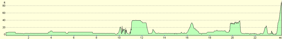
For more information on profiles, ascents and descents, see this page
Accommodation
We parked Mervan outside the Cricketers Arms, on South Meadow Lane in the centre of Preston. This was quite convenient for the station, although it was not the quietest road in the world and the locals were not that friendly.
Disclaimer
Please note that I take no responsibility for anything that may happen when following these directions. If you intend to follow this route, then please use the relevant maps and check the route out before you go out. As always when walking, use common sense and you should be fine.
If you find any information on any of these routes that is inaccurate, or you wish to add anything, then please email me.
All images on this site are © of the author. Any reproduction, retransmissions, or republication of all or part of any document found on this site is expressly prohibited, unless the author has explicitly granted its prior written consent to so reproduce, retransmit, or republish the material. All other rights reserved.
Although this site includes links providing convenient direct access to other Internet sites, I do not endorse, approve, certify or make warranties or representations as to the accuracy of the information on these sites.
And finally, enjoy your walking!
This walk was mentioned in the following routes:
| My walk around the coastline of Britain |
Nearby walks
| # | Title | Walk length (miles) |
|---|---|---|
| 421 | Seaforth to Southport | 20.0 |
| 423 | Preston to Lytham St Annes | 17.4 |
| 1038 | Leeds and Liverpool Canal: Cherry Tree to Wigan | 20.2 |
|
|

|