Walk #423: Preston to Lytham St Annes
 |
 |
|
General Data
| Date Walked | 24/04/2003 |
| County | Lancashire |
| Start Location | Preston |
| End Location | Lytham St Anne's |
| Start time | 08.04 |
| End time | 15.20 |
| Distance | 17.4 miles |
| Description | This was quite a varied walk, with a long stretch of road walking being followed by footpath and finally promenade walking, all along the northern bank of the River Ribble. |
| Pack | Today I carried my 30-litre Karrimor HotRock rucksack, which was filled with my packed lunch, waterproof leggings, water bottle and a couple of spare shirts, together with the usual assortment of odds and ends. |
| Condition | I feel absolutely fine after this walk, and could easily have walked further if the weather had been better. It is a good thing that I can do a walk of this length after doing such a long walk yesterday, and I feel very tempted to do another long walk when the conditions are right. |
| Weather | The day started off quite dry and warm, although there was a thin layer of cloud which the sun only occasionally broke through. There was not much wind, but I was not too warm anyway as I did not wear my fleece today. Towards the end of the walk it started to spit with rain, and for the last ninety minutes it was pouring with rain. It was not too cold, however, so the rain did not bother me too much. |
| OS map | Landranger number 102 (Preston & Blackpool, Lytham St Anne's) |
 |
 |
|
 |
 |
|
Map of the walk
Maps courtesy of Google Maps. Route for indicative purposes only, and may have been plotted after the walk. Please let me have comments on what you think of this new format. For a detailed table of timings for this walk, please see the table file.
 |
Notes
I did not sleep very well last night, which is surprising considering how tired I was after the long walk that I did yesterday. I was slightly uneasy after the girls who had been mucking about outside Mervan last night, and this probably stopped me from sleeping well. This evening we heard on the radio that a man had been arrested for stealing hundreds of pounds from a woman in South Meadows Lane at eight last night. This was the lane where we had parked, and so I am quite glad that we got away with just a disturbed nights sleep.
Sam drove me the short distance to the station in Preston this morning, in time to meet a reporter from BBC Radio Lancashire for an interview. The station is a lovely building, and I loved the detail of the vast overhead roof, and the granite columns at the main entrance. We walked as we did the interview, and it is going out tomorrow morning. It went quite well, although it is hard concentrating on what I was saying and the traffic at the same time! I was glad to find that there was a riverside walk past the 40-acre Albert Docks, completed in 1892, and I stopped to chat to a man who was working on the lock gates at he entrance to the docks. After this I had to join the A583 and follow this road westwards, and fortunately there was a pavement beside the road, and indeed beside the A584 that I had to join to reach Freckleton.
I met Sam at the library in Freckleton, and I spent over an hour there replying to various emails. I had not done this for over a month, so I had many outstanding emails that I chose to reply to. More and more people who have done or are doing the coastwalk are getting in contact with me - many of those who are doing it are doing it in sections. It is very nice to see that people seem to like my website, as I spend enough time every day writing up my notes and getting it ready! After I had replied to the emails I started doing some general web surfing, but after about ten minutes of this I soon got bored and decided to restart the walk. The staff in the library were very nice and kind, and I would like to thank them for their kindness.
The next section of walk followed the Lancashire Coastal Way from its start at Freckleton all the way to the end of this days walk in Lytham St Anne's. It initially headed southwards to Naze Point, before dropping down onto the foreshore an following this westwards to the outskirts of Warton aerodrome. This had high fences around it and signs forbidding photography, as it is one of the main bases for British Aerospace. They are currently in the process of updating RAF Tornado jets, and they are also building the prototype Eurofighters at the base. I was amused by one sign warning of flying debris, and nearby there was an impressive array of catch netting at the edge of the airfield. I would give my right arm to have a look at how they work in that sort of place - it is engineering on such a precision and massive scale, and I have a fascination for that sort of thing.
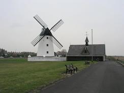
Lytham St Anne's is quite nice, and from the riverfront promenade it looks quite posh and very smart. The windmill is a lovely piece of work, as is the old lifeboat station (now a museum) beside it. I had a quick walk around the outside of the windmill, studying its design. The rest of the walk to the pier was very straightforward and quite enjoyable, but unfortunately it started to rain. I was not exactly a drenched rat when I arrived at the pier, but I was wet nonetheless, and thankful to reach the shelter of Mervan.
Tomorrow is apparently going to be a very wet day, so I am not setting myself a specific target. It would be nice to be able to reach Hambleton, but if the weather is bad I shall almost certainly cut it short. I am quite looking forward to the walk through Blackpool, and I hope that it is not raining so I can take lots of photos.
Directions
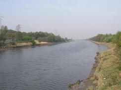
This walk starts off at Preston Railway station. Leave the main exit of the station and walk up the little slope past the taxi rank to the road junction. Turn left to head southwestwards for about half a mile until it ends at a junction with the A5072 road just before a bridge over the River Ribble. At the junction turn right and follow the A5072 northwards along the eastern bank of the river.
After a hundred yards a footpath, marked as the riverside walk, heads off to the left near a level crossing. Take this footpath and follow it as it heads westwards along the riverbank. When a set of locks are reached at the entrance to the harbour cross them and then continue on along the riverside path for a short distance until the rear of an engine shed is reached.
At the rear of the engine shed a path leads off to the right before ending at a road. At the road turn right and follow it as it curves to the left through an industrial estate and ends at the A583 dual carriageway.
Turn left and follow the A583 road westwards. There is a cycle path beside the road, and so it is a very safe walk. The road crosses Savick Brook and continues on until a junction with the A584 road is reached. Turn left down the A584 and follow it as it heads westwards for over two miles into the village of Freckleton - there is a pavement beside the road, so again this is a safe walk.
Immediately before the road enters the village a footpath heads off to the left; if you follow this footpath then it ends at a road that can be followed down to The Ship pub. I, however, wanted to visit the centre of the village, so I continued on along the A584 road until a roundabout was reached. I turned left at the roundabout down a road into the village, and then I turned left down another road that led past the library and to the Ship Pub, mentioned above.
From the Ship pub the rest of this walk follows the Lancashire Coastal Way, which is well signposted. It starts off by going down the road before becoming a footpath that heads southwards to join the northern bank of the River Ribble near a trig point at Naze Point.
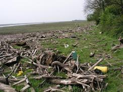
Here it descends to the marshland of the foreshore and turns to the right to follow the river westwards along the foreshore. From the driftwood that I had to clamber over in places I can imagine that this area could well flood on a high tide, so care may be needed. The path crosses a stream on a footbridge, after which it joins the fence around Warton Aerodrome, which it follows westwards before diverting off to the right to reach Warton Bank.
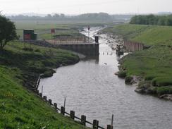
From Warton Bank the path continues northwestwards along a flood bank until it reaches a stream. Here it diverts inland for about a hundred yards to the A584 road, which it uses to cross the stream before going off to the left to rejoin the flood bank. This is followed westwards for about a mile until it reaches the A584 once more.
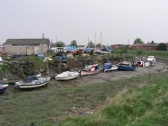
Turn left to cross a bridge and on the other side follow the well-marked path through a boatyard and along a flood bank back to the A584 road, which it then follows to the Lytham Land Registry building. Immediately past this building a path leads to a seafront promenade; turn right and follow this promenade westwards past the Lytham windmill and lifeboat museum and onwards past Fairhaven Lake before it joins a road near Lytham St Anne's pier, where this walk ends.
Distances
| From | To | Distance (m) | Ascent (ft) | Descent (ft) |
|---|---|---|---|---|
| Preston Station | Freckleton | 7.4 | 154 | 207 |
| Freckleton | Lytham St Anne's Pier | 10.0 | 243 | 272 |
This makes a total distance of 17.4 miles, with 397 feet of ascent and 479 feet of descent.
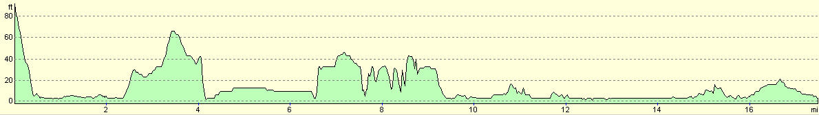
For more information on profiles, ascents and descents, see this page
Accommodation
We parked Mervan on the road that runs past the pier, about a hundred yards down the road from the pier. This was quite a busy road, but we felt it was better than where we parked last night.
Disclaimer
Please note that I take no responsibility for anything that may happen when following these directions. If you intend to follow this route, then please use the relevant maps and check the route out before you go out. As always when walking, use common sense and you should be fine.
If you find any information on any of these routes that is inaccurate, or you wish to add anything, then please email me.
All images on this site are © of the author. Any reproduction, retransmissions, or republication of all or part of any document found on this site is expressly prohibited, unless the author has explicitly granted its prior written consent to so reproduce, retransmit, or republish the material. All other rights reserved.
Although this site includes links providing convenient direct access to other Internet sites, I do not endorse, approve, certify or make warranties or representations as to the accuracy of the information on these sites.
And finally, enjoy your walking!
This walk was mentioned in the following routes:
| My walk around the coastline of Britain |
Nearby walks
| # | Title | Walk length (miles) |
|---|---|---|
| 421 | Seaforth to Southport | 20.0 |
| 422 | Southport to Preston | 24.7 |
| 424 | Lytham St Anne's to Thornton | 17.3 |
|
|

|